7
Maps
The Skim
Using Google Maps ![]() Search in Maps
Search in Maps ![]() Getting Directions
Getting Directions ![]() Getting There without a Car
Getting There without a Car ![]() Throw Away Your GPS Device
Throw Away Your GPS Device ![]() View Live Traffic
View Live Traffic ![]() Other Layers
Other Layers ![]() Driving with Your Phone
Driving with Your Phone ![]() Street View
Street View ![]() Google Places
Google Places ![]() Install a Compass
Install a Compass ![]() Find Out Where You Were with My Tracks
Find Out Where You Were with My Tracks ![]() Use Google Earth
Use Google Earth
I have to admit to being something of a map geek. For as long as I can remember, I have loved exploring maps. In college, my roommate and I had an awesome map of Antarctica on our wall; someday, I need to ask him what happened to it. I cannot bear to hear of someplace and not have any idea where it is.
The first generation of online maps did not foster my love of cartography. Those early maps were so painfully slow that they managed to suck whatever pleasure one might have gleaned from them; certainly, simply exploring the world was not a realistic option when each page could take 30 or more seconds to load. Today, however, not only can I waste hours randomly scrolling through maps online, I can do it on my phone. As a friend of mine likes to say, living in the future sure is cool.
USING GOOGLE MAPS
Google Maps changed how many of us get directions in as big a way as Google Search changed the ways in which we find information online. Google certainly did not invent online maps, but it did figure out how to do it right, by providing an interface through which users could easily scroll around on the map and zoom in and out, and most important, it made sure that it would all be fast. Later, Google added services that made Maps even cooler, with things like satellite imagery and traffic reports.
TIP 
Watch your battery! Few things drain your device's battery faster than GPS, so whenever you have Maps or any other application that uses it running, you are reducing your battery power dramatically. Merely locking your device while Maps is up does not shut down the application nor turn off GPS, which is something I learned the hard way on my first Android phone. You need to avoid long-term use of GPS anytime you are not going to be able to plug in your device either while you use it or shortly after.
Although finding directions from home works, being able to take those directions with you without having to waste paper is even better, and, of course, Google integrated its Maps application into Android from the very beginning.
You can open Maps from the Applications bin, but it is one of those applications that you are almost certainly going to want to add to your home screen as a shortcut. When you first open Maps, it should open to your current location, thanks to your device's GPS system (see Figure 7.1).
When viewing a map, you can zoom in and out using the buttons in the lower-right corner of the screen. You can also zoom in and out by pinching the screen — place two fingers relatively far from each other and bring them closer while remaining in contact with the screen to zoom out, or use the opposite action to zoom in.
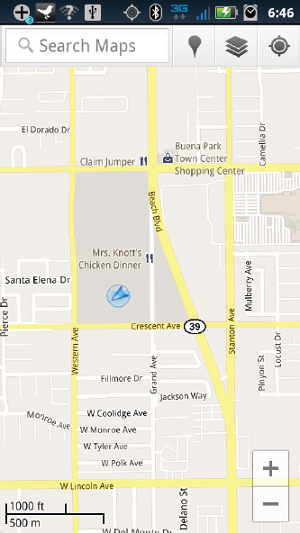
Figure 7.1 Maps, showing my location (blue arrow) by default
SEARCH IN MAPS
Most of the time, when you use the web-based interface for Google Maps, you begin by searching for an address. You can do the same in Maps on your phone — simply type the location into the search box at the top of the screen. You also can select the microphone button and speak your destination; this is a particularly useful, not to mention safe, feature for using Maps while driving. Assuming that the address you searched for was found, its location will now display on the map. If more than one possible location is found, Maps will display a list of results.
GETTING DIRECTIONS
After you find a location on Maps, you can get directions to that location. When your search location appears, select the balloon tip that is displaying the address to see a screen with additional options for that location. Select Directions, and you will be shown a screen where you can confirm the starting and ending locations, and then choose between Navigate and Get directions. See the next section for details on Navigate; for now, select Get directions to have the map generate driving directions.
The app will now highlight your route and display the first step in the directions. Arrows at the bottom of the Map view enable you to step through the directions, while the small square icon in the bottom-left corner displays the directions list view.
GETTING THERE WITHOUT A CAR
If you would prefer to get where you need by foot, bicycle, or bus, Maps can help. When you look up an address and choose to get directions, you see four buttons along the top of the screen, just under the addresses. The first, a picture of a car, is the one that is selected by default and gives you driving directions. The second button with the bus picture gives you directions via public transit. The transit directions use any form of public transit available in your area, including bus, train, subway, and ferry. The directions show options based on your time of departure (see Figure 7.2), and the system creates a route that takes into account necessary transfers. A particularly nice feature is the included indicators for the fares each leg of the trip will require.
TIP
Whether searching on your device or on the web, you do not need to know a specific address in order to find a location in Google Maps. You can search for an intersection by typing the names of the streets, so, for example, you could search for “Pennsylvania Ave and Executive Ave, Washington, DC” to find the corner near the White House. You also can search for local businesses near an address or landmark, so searching for “hotels near San Diego convention center” will give you ideas of where to stay for next year's Comic-Con. One of the coolest tips, though, will likely work only on your device: searching “pizza near me” will show all of the pizza restaurants near your current location.
Bicycle and walking directions (with appropriate icons) take into account the differences afforded by those choices. Bike routes take into account special bike trails, and in big cities, they stick as much as possible to routes with dedicated bike lanes and avoid rider-unfriendly parts of the route like big hills. Walking directions ignore things like one-way roads and, similar to bike routes, keep you on as flat a route as possible and stick to walking trails if possible.
THROW AWAY YOUR GPS DEVICE
In early 2010, Google rolled out a new, free application to many Android users, Navigate, which provides audio turn-by-turn navigation to your destination. Given that I frequently travel to new cities, I had at times considered purchasing a dedicated GPS device, but I am very glad I waited. Why would I need a special device, along with its monthly subscription fees, when my phone does it for me?
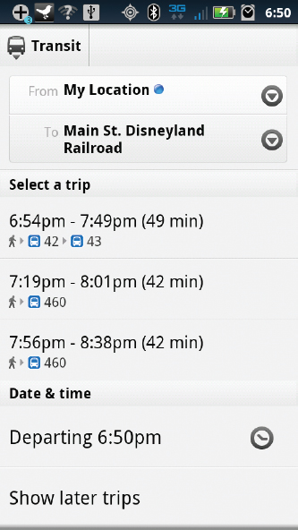
Figure 7.2 Getting there by bus
Whenever you search for an address and then ask for directions in Maps, it will ask whether you want to use Maps (Get directions) or Navigate. Navigate generally takes a few seconds to load, but after it does, you will see your route highlighted on the screen. The orientation switches to that roughly first-person perspective you probably have seen in dedicated GPS navigation systems (see Figure 7.3). You then receive turn-by-turn directions as you drive, using Navigate's built-in text-to-speech voice, which my daughter decided was named Sierra.
When you reach your destination, you should turn Navigate off. If it keeps running, even in the background, it will drain your battery very quickly. Press the Menu button on your phone and choose Exit Navigate to close it and save battery life.
By the way, I was kidding in the heading about throwing away your GPS device. Like all modern electronics, it has all kinds of nasty chemicals in it, so be sure to recycle it instead!
VIEW LIVE TRAFFIC
Maps will show you live traffic reports, allowing you to route yourself around problem areas. You can turn this feature on by pressing the Menu button on your phone and then selecting Layers. Select Traffic, and the map updates to display traffic reports. Green lines on roads mean that everything is fine; yellow lines mean you should expect traffic to be slow but still moving, and red roads are the ones you want to avoid (see Figure 7.4). Road hazards are displayed as well: An orange triangle icon signifies construction, while an icon of a collision signifies some other hazard, such as an accident or disabled vehicle.
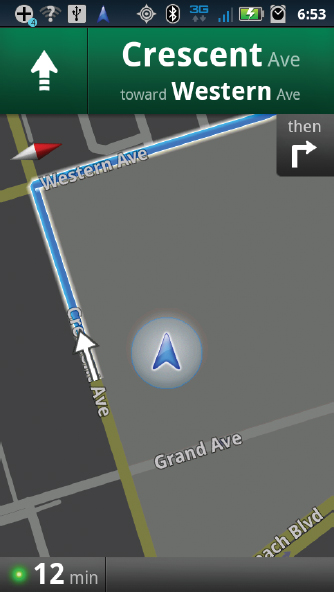
Figure 7.3 Turn-by-turn directions, thanks to Navigate
OTHER LAYERS
The Layers feature in Google Maps allows you to see the world in a variety of different ways. Traffic is a layer, but others exist as well. Each of these layers can be accessed by pressing your phone's Menu button, and then selecting Layers.
Satellite Photos
Instead of the traditional drawn map, you can view your route using satellite images. Personally, I tend to prefer the map view when I need to travel, but I have found the satellite view useful on occasion when trying to find a location: Seeing what the area around my destination actually looks like can be very helpful when I get close.
TIDBIT
Google collects traffic data from a variety of sources, but one of them is reading this book right now. Your GPS-enabled phone actually transmits your location and speed to Google in real time. Although I had long suspected this was the case, I actually confirmed it for myself one evening when I was driving along a rural road. Maps showed the route as green, which it was because I was the only car for miles. However, at one point I got hungry and pulled into a McDonald's drive-thru. As I was waiting for my food, I noticed that the road I had been on, which was still deserted, now was showing red, because the only data Google had at that moment was coming from a car that was stopped. By the way, if this triggers any lingering 1984 fears you might have, you can choose to opt out of the My Location system on your phone. Details on how to do this can be found at www.google.com/support/mobile.
Terrain Maps
Another layer available on Google Maps is Terrain. Hikers would find this particularly useful in planning routes.
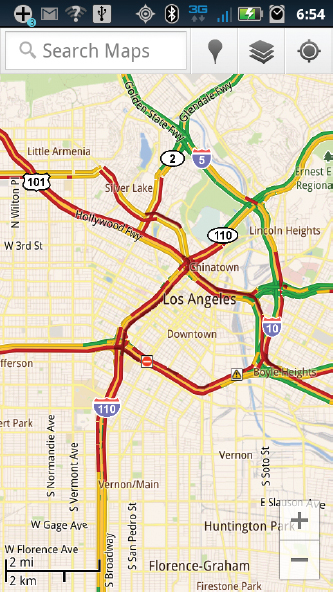
Figure 7.4 Monday afternoon traffic in New York City — Yuck!
Latitude
Google Latitude enables you to share your location with others and easily connect when nearby. When you select the Latitude layer, it displays your current location. You can select your name to display a list of options, including Send location to others. You have the option to broadcast this location on Facebook, Twitter, or other social networks, as well as text or e-mail it. If you join Latitude through its dedicated app, you also can send and receive invitations from friends and then easily discover their location. More information on Latitude is available at www.google.com/mobile.
Recent Places
The final set of options on the Layers menu lists the locations you have most recently searched, making it easy to look up a recent location and display it on the map.
More Layers
Select the More Layers button at the bottom of the Layers menu screen to see additional choices. The My Maps option displays maps you have created and saved on the Google Maps Web page. More details on creating and saving maps can be found at http://maps.google.com/support. The Bicycling layer displays local bike paths and routes (see Figure 7.5), and Wikipedia overlays icons on the map that link to Wikipedia entries for your area. The Transit Lines layer displays bus, train, and subway maps (see Figure 7.6). Finally, Favorite Places enables you to view maps created by other users.
DRIVING WITH YOUR PHONE
Features like Navigate are obviously most useful when used in your car. They are less useful, however, if your phone is simply sitting on the center console or in your pocket; in order to really benefit from the turn-by-turn directions, you need to be able to see your phone. You can maximize both the safety and convenience of these features by purchasing a car dock, which is a device designed to securely hold your phone on your dashboard. Each model of phone has a car dock specifically designed for it, so be sure to get the right one. Most car docks include a car charger, so if you are planning on getting a dock, you may not need to spend the additional money on a separate charger.
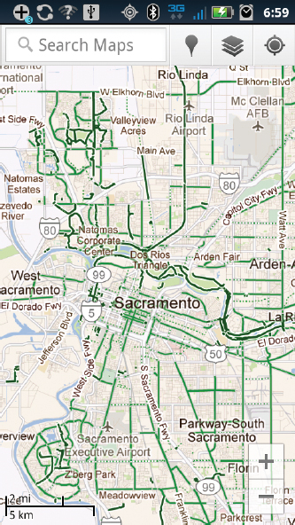
Figure 7.5 Bike paths in Sacramento, California
Many newer Android phones include a CarDock application that puts the phone into a state ready to use in your car. The phone automatically should detect when it has been put in the dock and switch to car mode by itself; if it does not, you can launch the application manually. The application includes six oversized, easy-to-hit buttons. Five are preprogrammed for music, maps, calling, voice search, and closing the application. The sixth is customizable and can be linked to any other application on your phone. When I first began playing with CarDock, I set this sixth button to the camera, which seemed kind of fun. When I was done playing, though, I reset it to launch the application I use the most in the car: TuneInRadio, which allows me to listen to Internet radio stations.

Figure 7.6 New York City's transit map
Whenever I drive, I keep the phone in the dock. I usually launch TuneInRadio and set it to the station I want to listen to, and then select the My Location button in CarDock. This ties directly into Google Maps, so if you have a layer already turned on, it will display; I almost always leave Traffic on. CarDock includes a few additional features, such as a speed and direction indicator in the bottom-left corner of the map. You can also search for a location and turn on Navigate to have your docked phone look and act just like a dedicated GPS device.
TIDBIT
GPS stands for Global Positioning System. Although consumer-level GPS is relatively new, the technology has been around for a while. The U.S. government began work on it in 1973, with the system becoming fully operational by 1995. The system relies on between 24 and 32 satellites and is still funded by the U.S. government and run by the U.S. Air Force. The system was designed to allow the Air Force and Navy to more precisely locate and control military assets, but following the 1983 destruction of Korean Air Lines flight 007, which was shot down after straying accidentally into restricted Soviet airspace, the U.S. government opened the system to civilian use as well. Today's GPS is capable of providing a location anywhere on the planet to within 20 meters, or about 65 feet.
When you receive a call while the phone is docked, it will interrupt whatever else the application may be doing to display the incoming call. If you have a Bluetooth headset or other hands-free device, you can accept the call by simply selecting the appropriate button, or possibly just saying “Answer”. If you do not have a hands-free device, you can still accept the call, at which point CarDock will turn on the speaker phone, in theory allowing you to have your conversation without needing to hold the phone to your ear. I say “theoretically” because although it does work, you will find that the noise in your car will likely be too loud to really talk on the phone this way.
A particularly nice feature of the dock is the integrated jack on the back that allows you to plug your phone in, because many features — particularly Navigate — would otherwise quickly drain the battery. Be aware, however, that your phone is likely sitting exposed on your dashboard and is susceptible to overheating, something that has happened to me on several occasions when it has been more than 100 degrees outside. When the phone begins to overheat, the first thing it will do is stop charging, so you should glance at the Notifications Bar every now and then and note whether you are still charging. If it occurs, remove the phone from the dock and move it someplace out of the sun until it can cool down. It is also possible that given that you are using the screen, GPS, Navigate, and other applications, the car charger will not be able to actually charge the phone, but will instead just keep it from discharging. Thus, you may find that when you arrive at your destination, your battery will not be at 100 percent.
Many newer cars include an input jack to allow you to plug a device into the car stereo. Because your phone uses a standard jack for the headphone, you can plug your phone in and listen to music, Internet radio, or Navigate's directions over the car's speakers.
STREET VIEW
Street view is perhaps one of Google's best-known features of Maps, so it is fairly surprising that although it is available on your phone, it is very well hidden. Street view allows you to see photographs of an area on the map, complete with 360-degree views. If you need to find a business or something in an unfamiliar location, this can allow you to see the area to which you are traveling. Note that like satellite photos, Street view is not live.
To access Street view, you need to zoom in on the map. As you get close to the ground, you begin to see buildings rendered in 3-D. At this point, you can long-press on a point on the map, which displays an address. Select the address to bring up a screen with details of that address, and you should see an icon on the far right of a person with an arrow. If the icon is grayed out, you have not zoomed in far enough to use Street view.
If you have zoomed in enough, the icon will be active, and selecting it will display that location in Street view (see Figure 7.7). You can swipe your finger to turn the view around and see around you, or use the dark arrows to move forward or backward.
GOOGLE PLACES
Recent versions of Google Maps include a new feature called Google Places, which displays information on restaurants, coffee shops, bars, hotels, attractions, ATMs, and gas stations near your current location. Places can be accessed by selecting the pushpin icon at the top of the Google Maps screen. Selecting this icon displays a menu of categories; selecting a category from this menu displays businesses matching that category. You then can select any of these locations to bring up more details about a business, get directions to it, or call the business directly.
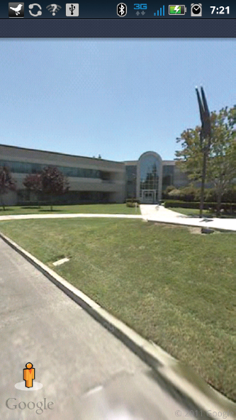
Figure 7.7 Google Headquarters in Mountain View, California, as seen on Street view
INSTALL A COMPASS
Your phone includes an internal compass that, among other things, ensures that the Navigate arrow is pointing in the right direction. The Android Market includes a Compass application that displays this directional awareness as a traditional compass (see Figure 7.8).
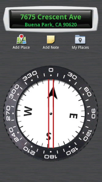
Figure 7.8 The Compass application
When you first launch the compass, it will prompt you to calibrate it by waving the phone in a figure-8 pattern several times. You might want to do this when no one else is around because you will look rather silly doing it.
You can press the Menu button to change the settings of the compass, including changing the type to look like an antique compass or a GPS device that includes your speed, pitch, and roll.
FIND OUT WHERE YOU WERE WITH MY TRACKS
The My Tracks application, available in the Market, enables you to track your location while walking, hiking, or other activities. These recorded paths then can be uploaded and saved and shared either as custom Google Maps or Google Docs. You can also view live statistics of your path while you go.
The first time you launch My Tracks, you need to agree to the license agreement and then, if you want, read the provided help file. After that, you are taken to a map that displays your current location. You can press the Menu button on your phone and select Record Track to begin recording. Then simply walk, run, hike, or drive the path you want to take. While on your route, you can select the map and then select the right arrow button that appears to view a screen of statistics about your track, or the left arrow to view an elevation profile.
When you have completed your path or route, you can again press the Menu button and then select Stop Recording, which displays a Track Details page, where you can give the track a name, input the type of activity, and describe the track. When complete, select Save.
To share the track, select the plus icon in the bottom-right corner of the screen and select the option you want to use. The Send to Google option uploads the map to either Google Maps or Google Docs, and Share with Friends enables you to e-mail a link to the map or send the track in one of several file formats.
USE GOOGLE EARTH
Few applications have brought out the map geek in me more than Google Earth. Earth is an amazing application that combines Google's database of satellite imagery together in a single, easy-to-explore interface. Earth was developed by another company, Keyhole, and released under its current Google Earth name in 2005. It now can be downloaded for free from the Android Market, bringing all of its coolness to your device.
When you first launch Google Earth, you can pretend momentarily that you are an astronaut, as you will see Earth from a distance that so far has only been viewed by the Apollo astronauts.
You can rotate the globe by simply sliding your finger over it, and zoom in by either moving two fingers apart from one another on the screen or by double-tapping. Eventually, details begin to appear. When you are in far enough to make out details, you will see yellow squares marking designated locations; selecting any of these will bring up a screen detailing that location. You can press your device's Back button to return to the main Google Earth screen from these detail pages.
Normally, dragging your finger on the screen moves you around the map. You can select the Look Around icon in the bottom-left corner of the screen to change this behavior. With Look Around enabled, dragging your finger will rotate your view 360 degrees around the center of the screen. You can select the icon again to turn off Look Around, and select the compass in the top-right corner of the screen to return to a north-is-up orientation.
With Look Around turned on, you can tilt your view so that rather than looking from above, you can see the world from more of an angle. You can tilt down by dragging upward on the screen (see Figure 7.9), or tilt up by dragging down on the screen. Although the directions may seem backward — you drag up to tilt down, and drag down to tilt up — they actually make a lot of sense when you are interacting with the application.
No Google application would be complete without Search, and Google Earth is no different. Press the Menu button on your phone and select Search, or press your phone's Search button. Then type what you are looking for, whether it is an address, landmark, business, or just about anything else. For the most part, the same searches that work on Google Maps work here. The main difference is the cool factor: In Maps, you are simply taken to your destination, while in Earth, you get to fly there. When the original Google Earth application was released, one reviewer described the animation as an “ICBM view,” which is apt as it will look like you take off, fly over the planet, and then dive in on your location (see Figure 7.10).
Unfortunately, many of the desktop application's really neat features are missing in this first version of the Android application, including the ability to go back in time and see older satellite photos of regions (using this ability to see pictures of New Orleans before and after Katrina is particularly moving) and exploring the Moon and Mars. Hopefully, Google will add them as time goes by.
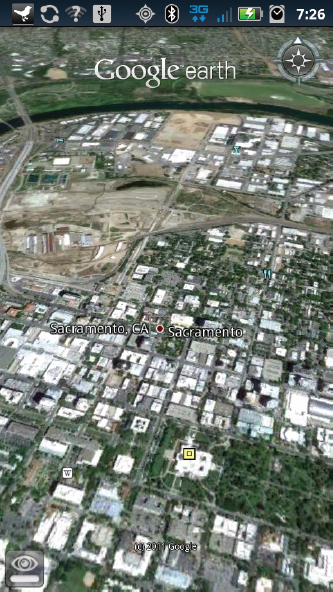
Figure 7.9 Seeing Sacramento at an angle
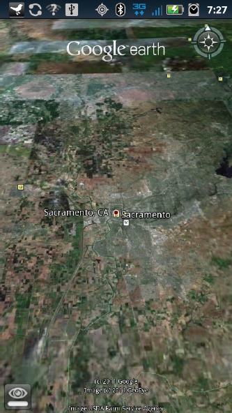
Figure 7.10 “ICBM view” of Google Earth