
BOSTON HARBOR ISLANDS
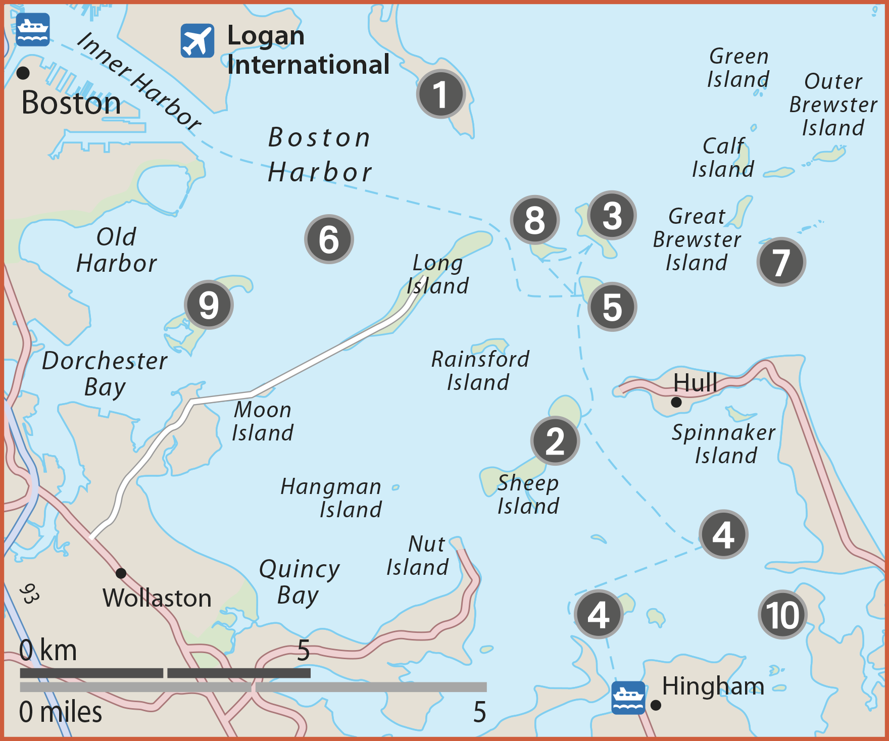
1. Deer Island
Accessed by a causeway attaching the island to the mainland, part of the island was opened in 2006 for recreation and walking – with dramatic views of the Boston skyline. Deer Island is also known for its impressive, state-of-the-art $3.8 billion sewage treatment plant. Distinguished by 12 gigantic egg-shaped digesters, it was key to cleaning up Boston Harbor.
2. Peddocks Island
Peddocks is one of Boston Harbor’s largest and most diverse islands. Hiking trails circle a pond, salt marsh, and coastal forest, and pass by Fort Andrews, which was active in harbor defense from 1904 through to World War II. The island is known for the beach plums and wild roses which bloom profusely in the dunes. A visitor center and campsite make it an overnight destination.
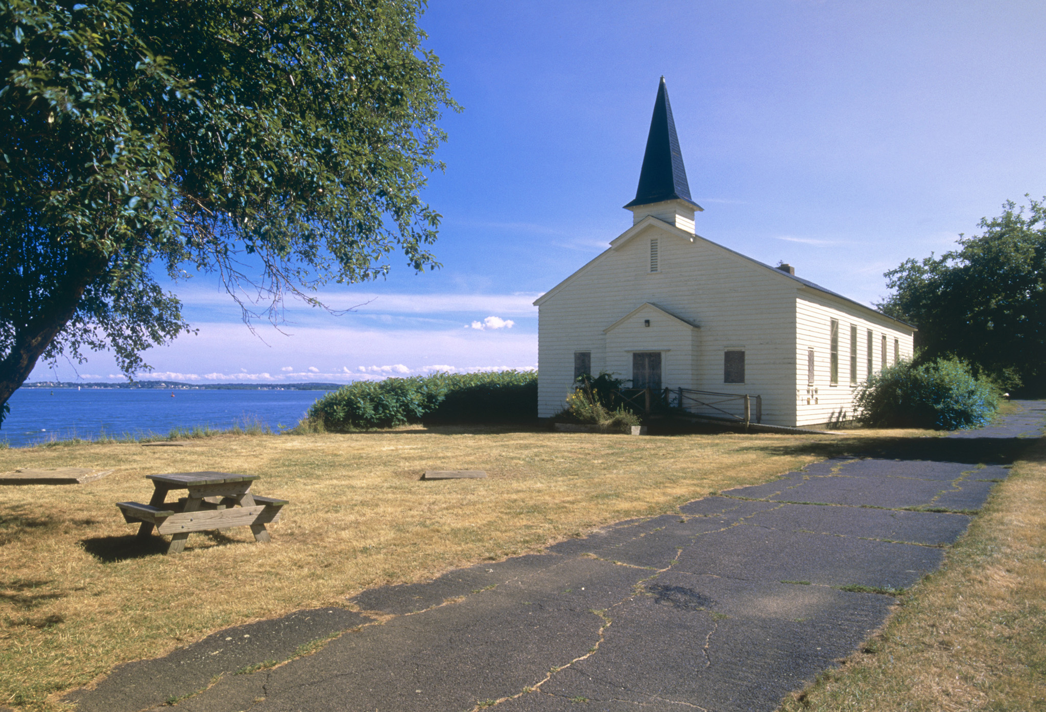
Church on Peddocks Island
3. Lovells Island
Known for its extensive dunes, Lovells also has an unsupervised swimming beach. Extensive hiking trails lead across the dunes and through woodlands. The remains of Fort Standish, which was active during the Spanish American War and World War I, can also be explored.
4. Grape and Bumpkin Islands
Both these islands are a delight for naturalists – Bumpkin for its wildflowers, raspberries, and bayberries, and Grape for its wild roses and bird life. On Bumpkin Island, hiking trails pass the ruins of a farmhouse and 19th-century children’s hospital, which also housed German prisoners rescued from Boston Harbor in World War I and later polio patients, before burning down in 1945.
5. Georges Island
![]() Islands open May–Oct (information booth at Long Wharf) • 617 223 8666 • www.bostonharborislands.org
Islands open May–Oct (information booth at Long Wharf) • 617 223 8666 • www.bostonharborislands.org
As the terminal for the harbor islands ferry and water shuttles to other islands, Georges Island is the gateway to the Boston Harbor Islands National Park Area, which includes 34 islands and mainland parks. Visitors can hike, explore historic buildings, view birds, and watch the passing ships. But it is also worth spending time here to visit the Civil-War-era Fort Warren and check out the snack bar and gift shop.
6. Spectacle Island
Vastly enlarged by fill from the Big Dig, Spectacle Island has some of the highest peaks of the harbor islands and the best Boston skyline view. The construction of a café and visitor center has made it one of the most popular of all the harbor islands. Visitors can enjoy 5 miles (8 km) of trails and swimming beaches with lifeguards.

The scenic Spectacle Island
7. Little Brewster Island
![]() Island closed due to storm damage, call for details • 617 223 8666 • Adm
Island closed due to storm damage, call for details • 617 223 8666 • Adm
Boston Light, the first US lighthouse, was constructed here in 1716 and it remains the last staffed offshore lighthouse in the country. Limited tours visit the small museum and lead visitors up the 76 spiral steps and two ladders to reach the top.
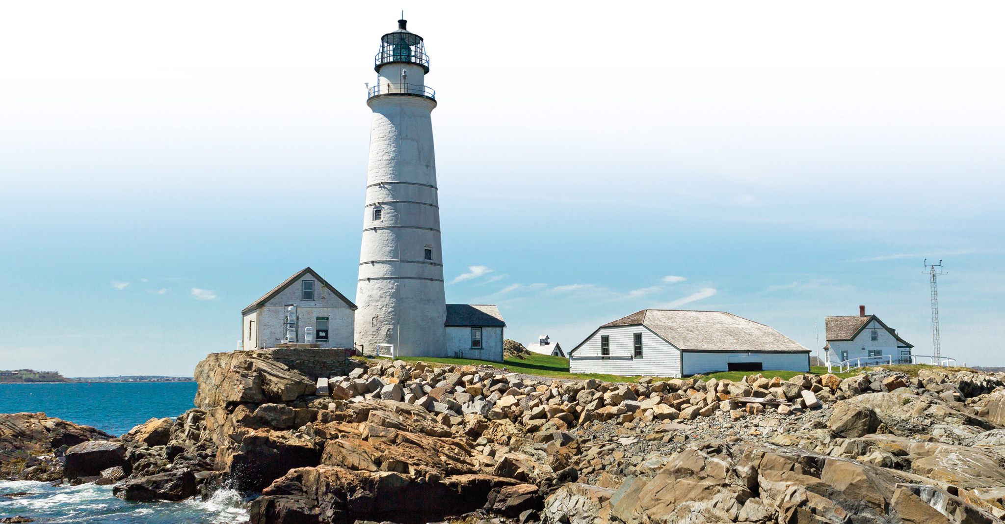
Little Brewster Island, with its historic lighthouse
8. Gallops Island
Once the site of a popular summer resort, Gallops also served as quarters for Civil War soldiers, including the Massachusetts 54th Regiment (see Boston Common and Public Garden). The island has an extensive sandy beach, a picnic area, hiking paths, and historic ruins of a former quarantine and immigration station. The Massachusetts Department of Conservation and Recreation has closed the island indefinitely for a thorough environmental clean up.
9. Thompson Island
![]() Open Jun–Aug: Sat & Sun • 617 328 3900 • Ferries depart from EDIC Pier off Summer Street • Adm
Open Jun–Aug: Sat & Sun • 617 328 3900 • Ferries depart from EDIC Pier off Summer Street • Adm
A learning center since the 1830s, Thompson is the site of an Outward Bound program serving more than 5,000 students annually. The island’s diverse geography includes rocky and sandy shores, a large salt marsh, sumac groves, and a hardwood forest. Killdeer, herons, and shorebirds abound.
10. World’s End
![]() Operated by Trustees of Reservations: 1 781 740 6665 • Adm for non-members
Operated by Trustees of Reservations: 1 781 740 6665 • Adm for non-members
This 0.4-sq-mile (1-sq-km) peninsula overlooking Hingham Bay is a geological sibling of the harbor islands, with its two glacial drumlins, rocky beaches, ledges, cliffs, and both salt- and freshwater marshes. Frederick Law Olmsted laid out the grounds for a homestead development here in the late 19th century. The homes were never built, but carriage paths, formal plantings, and hedgerows remain. World’s End is accessed by road by driving through Hingham.