
KURFÜRSTENDAMM
After years of decline, the Kurfürstendamm, or Ku’damm for short, has once again become a fashionable hot spot. Breathtaking architecture, elegant boutiques, and a lively street artist scene around Breitscheidplatz have made this shopping boulevard one of Berlin’s most attractive and—at 3.8 km (2.5 miles)—also its longest avenue for strolling.
NEED TO KNOW
![]() Europa-Center: Tauentzienstr. 9; (030) 348 00 80; open 24 hours (shops and Berlin Tourist Info: 10am–8pm Mon–Sat); www.24EC.de
Europa-Center: Tauentzienstr. 9; (030) 348 00 80; open 24 hours (shops and Berlin Tourist Info: 10am–8pm Mon–Sat); www.24EC.de
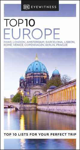
![]() Bikini Berlin: Budapester Str. 38–50; open 10am–8pm Mon–Sat, noon–6pm Sun; www.bikiniberlin.de
Bikini Berlin: Budapester Str. 38–50; open 10am–8pm Mon–Sat, noon–6pm Sun; www.bikiniberlin.de
- Few original cafés in the Kurfürstendamm area have survived. The most charming of these is the Café Wintergarten, located in the Literaturhaus on Fasanenstraße.
- Avoid Ku’damm on Saturday mornings when it is teeming with locals and tourists out on shopping trips.
1. Breitscheidplatz
Here, in the heart of the western city, artists, Berliners, and visitors swarm around J Schmettan’s globe fountain, known by locals as “Wasserklops” (water meatball).
2. Kaiser-Wilhelm-Gedächtnis-Kirche
While the church itself was destroyed during World War II, the church tower (see Kaiser-Wilhelm-Gedächtnis-Kirche) stands in the center of the square, serving as both memorial and stark reminder of the terrors of war.

3. Europa-Center
The oldest shopping center in West Berlin, opened in 1962, is still worth a visit. Here you will find fashion boutiques, a comedy theater, and an official Berlin Tourist Info center.

4. Neues Kranzler Eck
This glass and steel skyscraper was built in 2000 by architect Helmut Jahn. The legendary Café Kranzler was retained as a bar in front of the office block. There is an official Berlin Tourist Info center here.
5. Bikini Berlin
The Bikini-Haus building, built in 1956, was renovated to house the splendid Bikini Berlin, an ultra-hip boutique mall that also offers great views of the nearby zoo.
6. Iduna-Haus
The turreted building at No. 59 at the Leibnitzstraße corner is one of the few surviving bourgeois houses from the late 19th century. The ornamented Jugendstil (Art Nouveau) façade has been lavishly restored. The building is home to a number of banks.

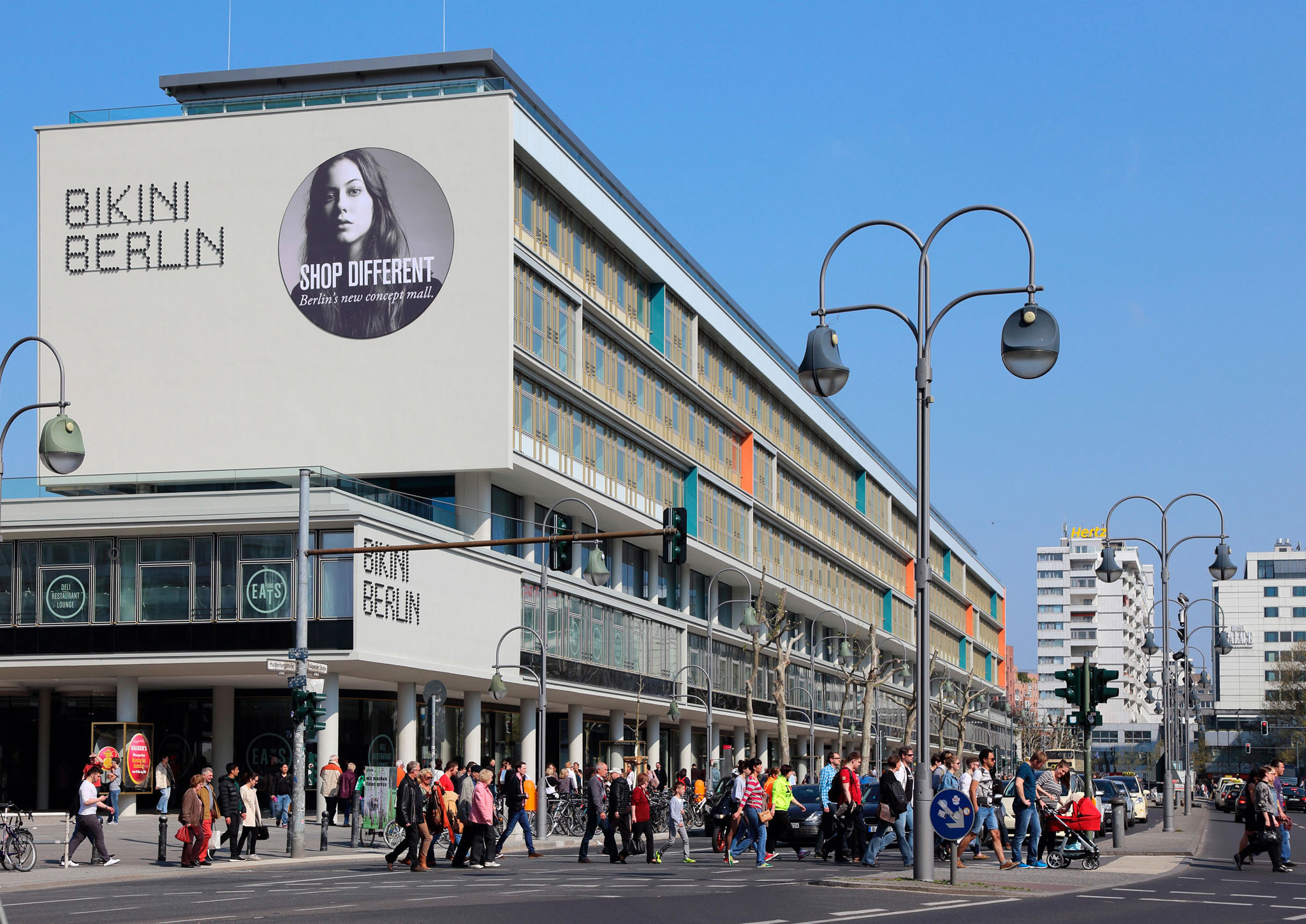
7. Lehniner Platz
The square is home to the Schaubühne theater, built as Universum cinema in 1928 by Erich Mendelsohn and converted in 1978.
8. Fasanenstraße
A small street off Ku’damm, Fasanenstraße, with its galleries, expensive shops, and restaurants, is one of Charlottenburg’s most elegant areas.

9. Traffic Turret
On the corner of Joachimstaler Straße stands an old-fashioned traffic turret or Verkehrskanzel, the last one in the city and now a heritage monument. A policeman sat in the raised glass cabin to control traffic lights manually from 1955 until 1962, when the signals went automatic.
10. RT&W Galerie
The Neo-Classical building housing this art gallery gives visitors a glimpse of Ku’damm’s erstwhile splendor.
WHEN KU’DAMM WAS NO MORE THAN A LOG ROAD
In 1542, today’s magnificent boulevard was just a humble “Knüppeldamm”, or log road. It served the Electors as a bridle path, linking their town residence (Stadtschloss) and their hunting lodge (Jagdschloss). It was not until 1871 that the area around the Ku’damm developed into a fashionable “new west end.” Chancellor Otto von Bismarck had the boulevard modeled on the Champs-Elysées in Paris, lined with houses, shops, hotels, and restaurants.