Utah
CANYONLANDS
ESTABLISHED 1964
In this vast, rugged wilderness, carved out by two mighty rivers, you’ll find dramatic desert landscapes and blissful solitude.
“The most weird, wonderful, magical place on Earth”... is how Edward Abbey, author, environmentalist, and desert lover, described the Canyonlands. After visiting this vast national park, carved from the Colorado Plateau by the relentless force of the Colorado and Green rivers, you will no doubt have fallen under its spell, too.
Quiet repose
The high, flat-topped mesas afford magnificent views over the rivers below, as they twist, turn, and plow their way across the red-rock landscape, plunging into deep warrens of hidden canyons. Hiking trails wind through pristine deserts punctuated by massive buttes and phenomenal rock formations. At night, the pitch blackness of the skies reveals a space-scape so dense you feel swallowed by the stars.
The park is divided into four districts: Island in the Sky, The Needles, The Maze, and the rivers themselves. Each has separate access points. There is also the remote Horseshoe Canyon, a rock-art “museum” of American Indian petroglyphs.
This wilderness park is a desert jewel for backcountry adventurers seeking peace, solitude, and a deep bond with nature.
7,120
The highest point in ft (2,170 m) is Cathedral Point, in The Needles District.
273
Number of bird species in the park.
50
Different mammal species living here.
3,700
The lowest point in ft (1,128 m) is Big Drop Rapids on the Colorado River.
Endless views
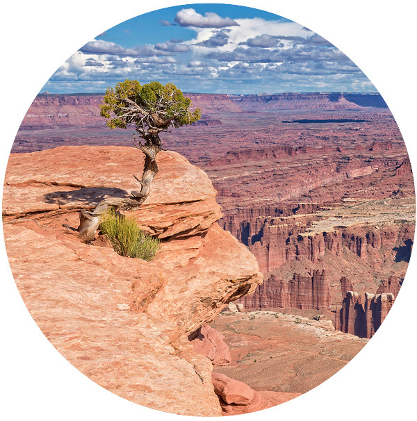
True to its name, Island in the Sky is a majestic mesa rising up more than 1,000 ft (300 m) in the air, with sheer sandstone cliffs that cut down through rugged canyons to the desert floor. The vistas are spectacular in every direction: east to the goosenecks of the Colorado River, west to the meandering Green River, and south toward the rivers’ dramatic confluence in the distant Needles.
This northern triangle is the most easily accessed section of the park. A paved scenic drive runs south for 12 miles (19 km) from the visitor center, with lofty overlooks such as the vertigo-inducing Shafer Canyon Overlook, where the cool breeze and warm sunlight enhance the sweeping views. A short loop trail leads to the enormous Mesa Arch on the edge of a cliff, its sandstone curve framing the layered canyons below snowcapped mountains.
At the Green River Overlook, the deeply gouged terrain following this waterway into the distance is a dramatic sight. The panorama from Grand View Point at the southern tip of the mesa sweeps across the Canyonlands, giving you one of the best views in the park.
There are easy walking trails for casual day hikes here, as well as more strenuous routes that take you down into the canyons. White Rim Road, a rough four-wheel-drive road that loops for 100 miles (160 km) around and below the mesa top, is a favorite with mountain bikers.

Early risers will be rewarded with spectacular photos of the morning sun lighting up Mesa Arch.
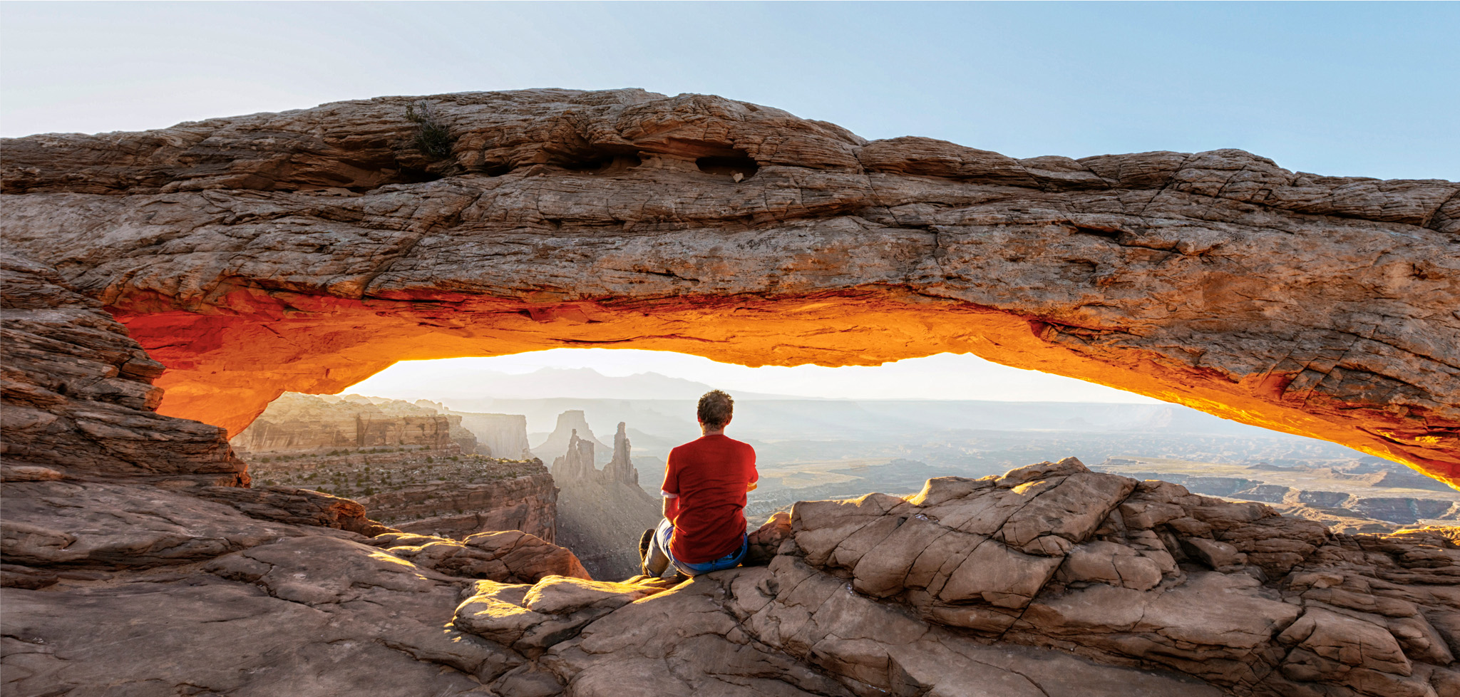
As it rises in the sky, the sun glints off the rocks at Mesa Arch
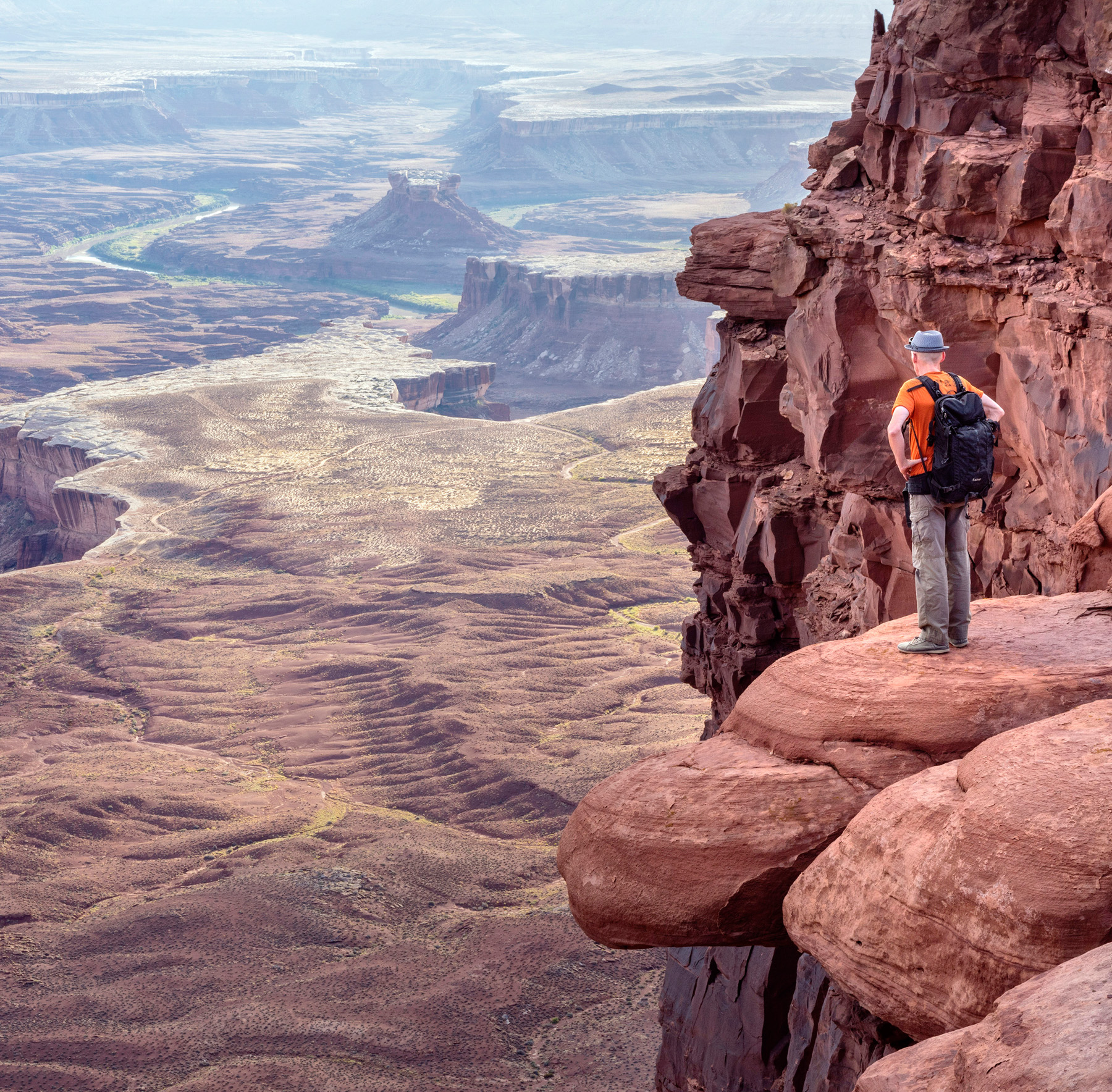
After an arduous trek to an outcrop on Island Sky Overlook, a hiker pauses to marvel at the natural wonders laid out below
Reaching for the skies
The Needles district is famous for its orange- and white-banded spires, visible for miles. You’ll have to hike to see these sandstone giants up close, through a landscape festooned with red-rock arches, monoliths, and other amazing formations.
This southeastern section of the park is much less visited, and you’ll know you are in the backcountry here. The only paved road runs 10 miles (16 km) in, offering tantalizing views of the Needles in the distance before ending at the Big Spring Canyon Overlook. From here, you can hike to a viewpoint that looks down on the two mighty rivers hundreds of feet below.
The Needles is lower in elevation than other areas, but what it lacks in scenic viewpoints, it makes up for in glorious hiking trails and four-wheel-drive roads. There are short, easy walks to Cave Spring and Pothole Point, where rainwater shimmers in natural wells in the rock. Longer, sometimes overnight, hikes take you along rugged ridges and canyons, across sandy washes, and through narrow slickrock passes culminating in stunning natural arches and the Needles themselves.
The Needles district is also rich in archeological sites, especially in Salt Creek Canyon, where many Ancestral Puebloan and Fremont structures have been preserved. At Roadside Ruin, you’ll find a fine example of a prehistoric granary.
Three Hikes
Easy ▷ Grand View Point Trail, Island in the Sky, 2 miles (3 km) round trip. Walk along the clifftop to the tip of the mesa, where a stupendous view of Canyonlands stretches before you.
Moderate Slickrock Foot Trail, The Needles, 2.4 miles (4 km) round trip. Look for bighorn sheep on this open, unshaded, rocky trail that ends in panoramic views.

Challenging ▷ Maze Overlook Trail, The Maze, 8 miles (13 km)round trip. Among the highlights of this tough trail are pictograph panels and views of the Chocolate Drops rock formation.
Backcountry challenge
Only the most determined travelers see the wilderness landscape of The Maze. This remote southwestern district of the Canyonlands is only reached along rough four-wheel-drive tracks or from the river. Its hiking trails are strenuous, if not downright dangerous in places. Anyone who ventures here must be self-sufficient.
And yet, for experienced backpackers, the challenges of The Maze are exhilarating and its desert solitude is sublime. Given the slow, difficult journey to simply get here, most stay for at least three days (permits are required). Their scenic trophies are worth every bone-rattling mile. There are the towering orange walls of organ shale, called the Chocolate Drops, rising from a ridge. And the remarkable Chimney Rock, defying gravity in the Land of Standing Rocks. From there, a trail drops down into Pictograph Fork, an isolated canyon that shelters amazing panels of prehistoric rock art known as the Harvest Scene. And from the hoodoo spires of the Doll House, hikers descend to the Colorado River at Spanish Bottom and continue along its banks to a series of rapids.
Hunter-gatherer artistry
Horseshoe Canyon, an isolated unit west of the main park, contains some of the most important rock art on the continent. Its finest panel, the Great Gallery, depicts life-size figures in evocative detail. They hover on the canyon wall, the ethereal, ancient guardians of this sacred place.
The figures are painted in the Barrier Canyon style, which dates to the period from 2000 BC to AD 500, a time when nomadic hunter-gatherers lived seasonally in the canyon. The site features both painted figures (pictographs) and artistic symbols etched into the rock (petroglyphs). Later panels were added by Ancestral Puebloan and Fremont cultures.
In the early 20th century, ranchers established trails into Horseshoe Canyon so that their livestock could graze and find water. Today, the old cattle path makes a beautiful, if long—7 miles (11 km) round trip—hiking trail, leading you down between the sandstone walls to the cottonwood groves and bubbling stream on the canyon floor, a timeless entry to this incredible display of prehistoric art.
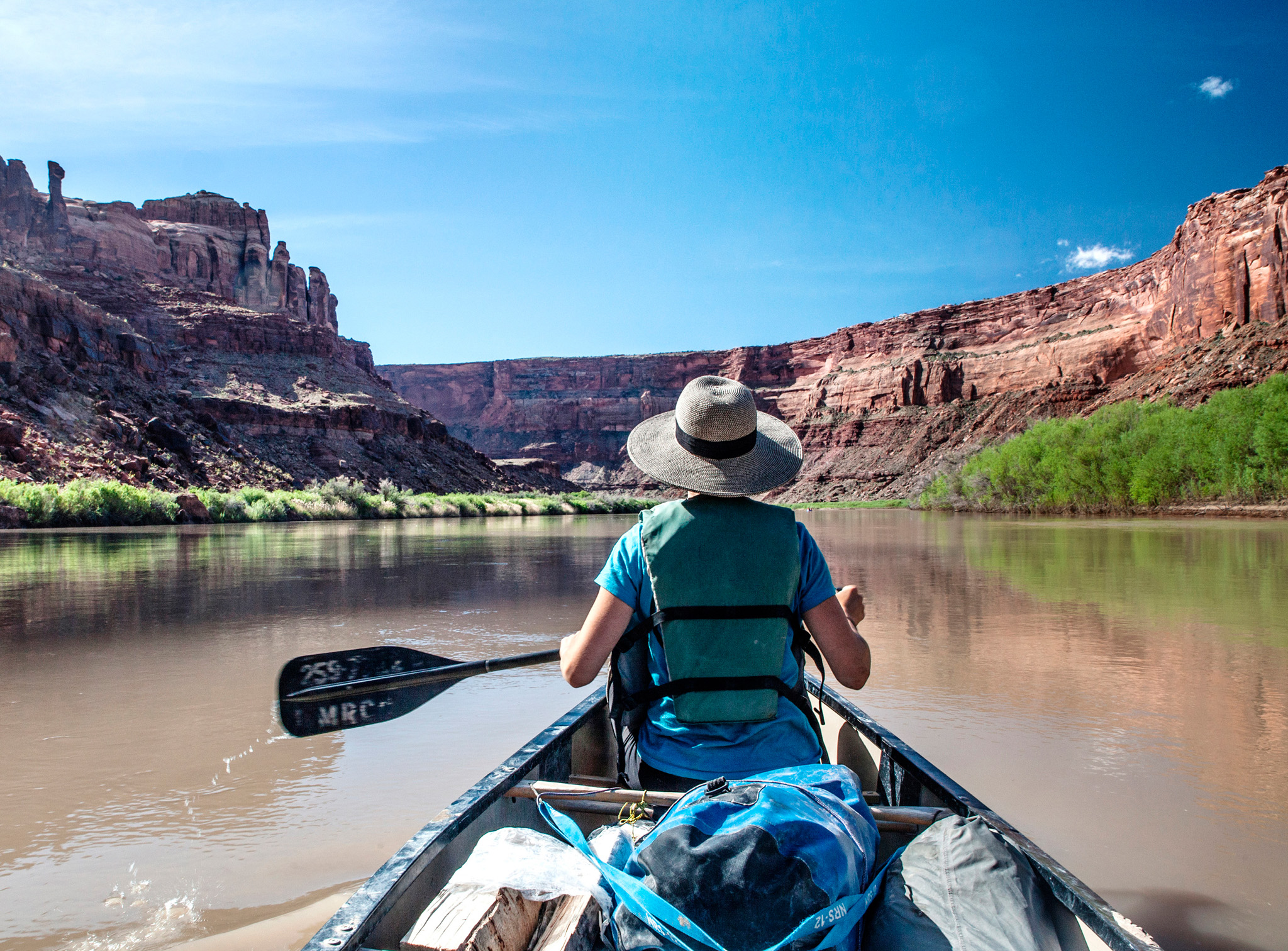
A canoer paddles down the tranquil and scenic Green River
BEST FOR
Stargazing
Remote national parks like Canyonlands offer some of the darkest skies in the country. Away from urban light pollution, you can see up to 30 times the number of stars you would see in a city setting. The pristine night skies at Canyonlands are so superb that the park was designated a Gold-Tier International Dark Sky Park in 2015. When conditions are right, you may even be able to sight the rings of Saturn through your binoculars.

Take to the water
The final district of Canyonlands National Park is the great rivers themselves. Above the confluence, the waters are calm and you can paddle lazily in kayaks and canoes, or simply float on a raft, gazing up in bliss at the surrounding desert beauty. But after the Green and the Colorado merge into one mighty river, they plunge into a torrent of whitewater that blasts through rapids in the 14-mile (22-km) Cataract Canyon.
Whether you ride the waves on a raft adventure, hike the desert trails, or admire the vistas from above, the Canyonlands are truly one of Earth’s magical places.
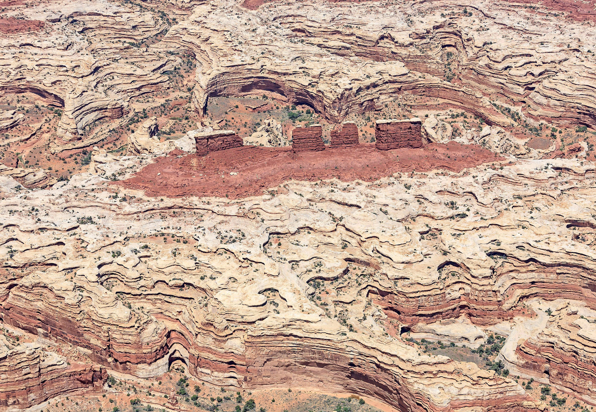
This view from afar shows clearly just why The Maze district is such challenging terrain
Did You Know?
Robbers Roost, the hideout of Butch Cassidy’s outlaw gang, is hidden in The Maze district of Canyonlands.
FOCUS ON
Nature’s Sculptor
Some 300 million years ago, when the Canyonlands stood at sea level, sand and rock from distant mountain ranges were carried here by water and wind. Over time, they solidified into geologic layers that built up across massive plains. Then, some 20 million years ago, an uplift in the Earth created the Colorado Plateau. The Colorado and Green rivers now reversed the process, eroding down through the layers to create the canyons.

Winding desert roads inside the park afford stunning views