5
iParking—Smart Way to Automate the Management of the Parking System for a Smart City
J.A.D.C.A. Jayakody1*, E.A.G.A. Edirisinghe1, S.A.H.M. Karunanayaka2, E.M.C.S. Ekanayake2, H.K.T.M. Dikkumbura2 and L.A.I.M. Bandara2
1Department of Computer Systems Engineering, Sri Lanka Institute of Information Technology, Malabe, Sri Lanka
2Department of Information Technology, Sri Lanka Institute of Information Technology, Malabe, Sri Lanka
Abstract
Due to the highest usage of vehicles which occurs with developing economy and the improved city modernization level, traffic congestion and parking have become one of the main social problems. Despite the progress, there is still a need for an enhanced and distributed solution that can exploit data and provide an appropriate and real-time method on parking systems. This paper describes the design and implementation of a smart parking management system (SPMS) which can solve the previously mentioned parking problem. Huge traffic causes a considerable deal of damage, like the increment of accidents, the air pollution caused by a substantial amount of CO2 released by vehicles, and the unnecessary stress on drivers who must drive in often narrow and very busy roads and time wastage to find a free spot to park. Thus, to take care of the parking issue, present day advances have been made to furnish vehicle parks with smart devices that help street clients to identify the nearest available car park. In this paper, the development of the new fully automated parking system which is called iParking is presented. IParking is a design and a development of a smart parking system that will ensure the implementation of the outdoor parking system for the Smart City concept by using image processing (IP) and machine learning (ML). With connected to smart parking, a mobile app alerts the user about available spaces and guide user to the exact location with accuracy. IParking system aims to take the driver’s stress out while finding a parking space in city centers where all cars in the city are looking for parking slots in the same time.
Keywords: Smart parking, machine learning, internet of things, convolutional neural networks, artificial neural networks, short message services
5.1 Introduction
Nowadays the vehicle usage has increased and vehicle parking has become one of the serious issues in urban zones of both developed and developing countries. Today in the world 55% of the people live in urban areas and the proportion that we can expect it to increase is 68% by the end of 2049 [1], which will at last lead to expanded blockage and interest for a huge upgrade of smart traffic management. People spend more than 7 min in searching for a parking spot. This helps like 30% of the traffic flows in cities [1] and contributes to traffic congestion during peak hours.
Finding an available parking space is a basic issue in most present day urban areas, especially the shortage of available vehicle spaces is clear in numerous open spots such as universities, hotels, market areas, hospitals, shopping malls, and airports. Moreover, many outdoor vehicle parks create a traffic jam which happens while searching for a parking place. Smart cities especially have gotten to be one of the key reasons for the city gridlock, air pollution and driver frustration. Thus, there is a huge need for a real time, secure, intelligent, efficient and reliable parking system. Furthermore it should be used for looking through the vacant parking slots, direction towards the parking process, negotiation of the parking fee, along with the proper management [17] through the whole parking process.
Through this research a smart parking system which is known as iParking, allows drivers to access parking information through their smartphones. In this research, a smart parking system that allows drivers to effectively find the available parking places with accurate root guidance and automated payment facility was designed and implemented. An effective solution to this system can be provided by various new technologies. In this paper, firstly an overview of the concept of the iParking system, their categories, and different functionalities are given. This research describes the technologies around parking availability monitoring, accurate root guidance to the available parking lot, parking reservation and pricing according to the vehicle type and time.
iParking includes the development of an android mobile application to book the parking area. There is no manual process, the whole parking system is automated and it helps to save time. The mobile application is developed with a registration page. First of all, in this registration step the car number will be checked automatically when the car enters [14, 15]. Then the vehicle can be parked according to their booking. The main goal is to provide a time-saving parking system that prevents traffic and confusion while parking. The iParking system results in time-saving parking through the booking facility for parking through an android application and the automated car recognition and parking slot status. Outdoor advertising, it exhibits huge advertisements to passing drivers. It exhibits huge advertisements to passing pedestrians and drivers. These types of advertisements are intended to catch the attention of the target audience in a blink of an eye and thus have a lasting impact on the mind of the reader.
Smart Parking systems typically gather information about available parking spaces in a particular geographical area and the process is real-time to place vehicles according to the available positions. It involves real-time data collection, low-cost sensors, getting GPS correct location details and mobile-phone-enabled automated payment system that allow people to find parking in advance or very accurately anticipate where they will probably discover a spot. When deployed as a system, iParking thus reduces car emissions in urban centers by reducing unnecessary city blocks which happens while searching for a parking space. It also permits people and cities to carefully manage their parking facility. According to Figure 5.1, iParking could help in 220,000 gallons of fuel savings till 2030 and approx. 300,000 gallons of fuels saved by end of 2049 [16].

Figure 5.1 Analyzing efficiency in parking [16].
5.2 Background & Literature Review
5.2.1 Background
A lot of cities worldwide are working to become smart. One of the most popular applications in smart cities is the smart parking system, as they help people to save time, reduce fuel consumption, and decrease carbon dioxide emissions. Smart parking systems have a defined architecture with specified components. Although there are many kinds of research done, still a small amount of work has been done for the concept of outdoor smart parking systems in Sri Lanka.
Furthermore, most of these parking systems do not cover the following areas: real time availability of slots in different weather conditions, navigating user to the available slot by showing the position with great accuracy and the facility of the fully automated parking payment system by detecting vehicle number plate in any condition and by providing payment patterns. Most importantly a lot of systems do not have a unique market value because most parking systems only provide the parking facility and do not focus on providing some benefits for the users who come to the parking area, like digital targeted advertising.
Many researchers have successfully implemented many algorithms to detect objects. But a small amount of work has been done to identify vehicle occupancy detection in the outdoor parking area under various conditions such as flexibility under different lighting varieties and meteorological conditions which will provide efficiency and high accuracy for real-time delivery.
Also, there are many algorithms and methods to correct GPS errors because when more precise positions require, errors in GPS data need to be corrected. Thus, positioning accuracy is a challenging issue for location-based applications, but a small amount of work has been done in using map-matching algorithms to correct these GPS errors that provide more accurate results.
Furthermore, this smart parking system is to develop User Targeting Techniques that is the process of predicting the relevance of advertisements. Many industries are sending fascinating models to make target crowd bunches for different commercials. The work in this area includes Analysis using Machine Learning and it is capable of identifying and displaying the relevant content of a particular object.
Image processing is used to recognize vehicles by identifying license plates. It is basically used for parking access control and security purposes. First, the vehicle comes near the entrance gate and a signal is sent to the camera. Then the camera is activated and takes a snapshot.
The system applies certain algorithms to analyze the vehicle image. Next, the image is enhanced, the vehicle plate is placed, and the character is extracted from the vehicle plate. The system attempts to coordinate the perceived vehicle plate number to the vehicle license plate database. If “Allow”, the gate will open, then vehicles will be allowed through.
Recognition of vehicle license plates also has the advantage of storing images of vehicles that can be used to fight crime. Vehicle speed, weather conditions, vehicle type, distance between vehicle license plate and camera, plate type (rectangle, bent type), orientation of vehicle license plate, vehicle font character type, efficiency, and accuracy are variables that affect the recognition system [19].
License plates usually have a rectangular shape with a known aspect ratio, so they can be extracted by finding all possible rectangles in the image [18]. To find these rectangles, an edge detection method is commonly used.
Hence, a literature review is carried out based on every sub topic.
5.2.2 Review of Literature
“Smart parking reservation system using short message services (SMS)” by Hanif, Badiozaman and Daud [5] have presented a smart parking system which reduces the time wastage during finding a parking spot in commercial car park areas [5]. This parking reservation framework is inherent such a way that clients can book their parking spots via a SMS. The system has developed as a fully automated system by using a Peripheral Interface Controller (PIC). This microcontroller is able to store data about available parking spaces, include passwords and permit or deny access to the parking area. A prototype of a car park system was designed to show the potential of the proposed work. The demonstration has shown the system’s ability to reserve the car park, gain entry to the parking area and thus remove the hassle of looking for empty parking lots. There are many advantages in this system. Such as; enhance security with password requirements and with the ease of use, the system can be used and applied anywhere. And there are some disadvantages either, like; High installation cost, GSM function creates a bottleneck and the microcontroller needs to put a lot of lads that can disturb the system.
Yang, Portilla, and Riesgo et al. stated that “Smart Parking Service based on Wireless Sensor Networks” [6] and, the authors have presented the design and implementation of a Smart Parking Services prototype system based on Wireless Sensor Networks (WSNs) that allows drivers to effectively locate the available parking spaces [6]. This system consists of wireless sensor networks, embedded web server, central web server, and mobile phone applications. In the system, low-cost wireless sensor network modules are installed in each parking slot equipped with one sensor node within the device. The parking space status is detected by the sensor node and is periodically reported to the embedded web server via the wireless sensor networks that are deployed. Using Wi-Fi networks in real time, this information is sent to the central web server and the vehicle driver can locate empty parking lots using regular mobile devices too. The android app is easy to use and with a great interface, GPS helps cover the maximum area available and it displays various options for parking can be listed as advantages of this project, while the user cannot use the reservation function, unavailability of multi-layer parking in infrastructure can be listed as disadvantages.
Shih and Tsai et al. stated that “A Convenient Vision Based System for Automatic Detection of Parking Spaces in Indoor Parking Lots Using Wide-Angle Cameras” [7]. They have proposed an indoor vision-based parking system. The wide-angle fisheye-lens or cat dioptric cameras which are easy to set up by a user with no technical background were proposed in this research. Easiness of the framework arrangement mostly originates from the utilization of another camera model that can be aligned utilizing just one space line without knowing its position and heading. Also the camera allows convenient changes in detected parking space boundaries. A genuine vision-based parking area has been built up and important examinations directed. The accuracy, practicality, and strength of the proposed techniques were showed by experimental results. Although it has disadvantages like; No mean is provided to address weather conditions that may affect visibility and Reservations. General users can easily set up the system without any technical background and wide angle camera is used to cover the entire territory of the parking area can be categorized under advantages [7].
“Automated Parking System with Bluetooth access” by Singh, Anand, and Sharma [8] have developed a fully automated parking system for both two wheelers and cars. This described system extemporizes upon the current parking framework by improving its security includes and mechanizing the parking process accordingly wiping out the requirement for manual mediation. The system has an inbuilt Bluetooth reader to authenticate and identify the owner. This kills the utilization of tokens or paper bills. Space the executives and mechanization are performed with the assistance of an ARM microcontroller which controls the mechanical engines to leave the vehicle at a fitting parking area [8].
“Car Park Management with Networked Wireless Sensors and Active RFID” by El Mouatezbillah, Djenouri, Boulkaboul and Bagula [9] have proposed an automatic car park management. Integration of networked sensor/actuator and radio frequency identification (RFID) technologies was used and the emerging internet of things (IoT) context was used as service provider. In view of this combination, they have proposed a scalable and low-cost car parking framework (CPF). A fundamental model usage and experimentation of certain modules of the proposed CPF has been performed. Trial results exhibit extensive decrease in cost and energy consumption [9].
“Automatic Parking Management System and Parking Fee Collection Based on Number Plate Recognition” by Rashid and Musa [10] have talked about an automatic parking system and electronic parking fee collection method based on vehicle number plate recognition. The objective of this system was to create and execute an automatic parking system that would increase the effficiency and security of the public parking lot as well as collecting parking fees without using a magnetic card. This system is developed with less human interaction. Hence it was a big help to develop the iParking system which is a fully automated smart parking system. iParking system contains fully automated parking guidance system as in this research. In this research they have used image processing in parking operation and payment procedure, and in iParking system machine learning will be used to minimize the errors of image processing [10].
“New Smart Parking System Based on Resource Allocation and Reservations” by Geng and Cassandras [11] have suggested a new method of “smart parking” for a city environment. The system allots and saves an ideal parking space dependent on the cost capacity of the driver joining the vicinity to the objective and the expense of parking. The system approach solves the problem of mixed-integer linear programming (MILP) at every point of the decision specified in a time-driven sequence. Based on simulation results, compared with uncontrolled parking processes, this system reduces the time wastage on finding a parking space, whereas the overall parking capacity is more efficiently deployed. They have also described full execution in a carport to test this system, where another light system conspires is proposed to ensure client reservations [11].
“An Accurate GPS-IMU/DR Data Fusion Method for Driverless Car Based on a Set of Predictive Models and Grid Constraints” by Wang, Deng and Yin [12] have proposed an accurate GPS–inertial measurement unit, data fusion method in view of a lot of prescient models and inhabitance framework requirements.
In this paper, the system proposes a novel data fusion method for precise localization problems of driverless cars using a set of ARMA predictive models and occupancy grid constraints. It is only based on on-board GPS– IMU and DR navigation data [12].
Study on “Differential GPS Positioning Methods” by Shao and Sui [21] have presented about the three typical methods for differential GPS according to the different type of information sent by the base station, they are differential position; differential pseudo-range; differential carrier phase [21].
From this research the main idea about GPS positioning was gained [21].
“Automatic parking space detection system” by Bibi and Nadeem [3] have presented a vision based smart parking framework to assist the drivers to find an appropriate parking space and book it efficiently. In here they have used image processing and though this research image processing procedure can be understood. When the car enters or exits the parking lot, its presence and details like size of the vehicle take into an account and those information will be used in further process [3].
“Parking spaces modeling for inter spaces occlusion handling” by Masmoudi and Wali [2] suggested an idea to provide smart parking performance and to solve the problem which caused due to the lack of space in parking areas and also between two vehicles. They used an event-based detection approach to detect objects and tracked them using a Kalman filter. The goal of this paper is to introduce a new approach to provide parking vacancies with reliable results and to address the problem of interplace occlusion [2]. This research paper is proposing a new approach for the parking architecture extraction in view of the on-road surfaces, as it is the less impeded model.
Then arrangement of the cars in the parking area, mentioned parking spaces on street surfaces shown in Figure 5.2 with red area, will reflect the parking model with the less occlusion possible and provide good performance for the detection of parking events [2].
Fabian et al. stated that “An algorithm for parking lot occupation detection” [4], and he has proposed an unsupervised vision based system for parking space detection. But they have used image processing to work under many different conditions. This system claims that the major problem in images detection is the occlusions and shadows using recognition algorithms [4].
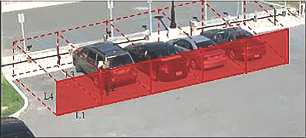
Figure 5.2 Different parking models presentation [2].
“Parking lots space detection” by Wu and Zhang [13] have proposed a parking detection system which has the following steps:
- pre-processing
- extraction of model features
- multi-class SVM (Support Vector Machines) recognition
- MRF (Markov random field)-based verification [13].
Initially, the input video outlines are turned to uniform axes and portioned into little fixes containing 3 parking spaces such as Figure 5.3. This paper presented a novel method via using only a few frames which are captured by a single camera for unsupervised parking lot space detection [13].

Figure 5.3 Preprocess the input frame and generate detecting patches [13].
“Parking space classification using convolutional neural networks” by Cazamias and Marek [18] have described a parking occupancy classifier. In this research they have used convolutional neural network (CNN) as a classifier. The workhorse of this algorithm is a Convolutional Neural Network (CNN), a deep learning data structure that works especially well for computer vision tasks [18].
“Networked Wireless Sensors, Active RFID, and Handheld Devices for Modern Car Park Management” by Djenouri, Karbab, Boulkaboul and Bagula [19] have implemented a Car Parking Framework (CPF) which can manage a smart parking system that combines sensors (detection of parking spaces), RFID tags, and readers [19]. This system uses serial cable communication.
Sharma, Kulkarni, Kalbande, Dholay et al. stated that “Cost Optimized Hybrid System in Digital Advertising using Machine Learning” [20], but they have suggested an Audience Targeting Strategies method of predicting the importance of ads to individuals. Machine learning algorithms analyze the personal data of individuals that they share with companies on a voluntary basis. The results are promising for targeting the audience [20, 21]. The authors have suggested many deep neural network techniques.
Audience Expansion: Audience Targeting Techniques is the method of assessing the importance of ads to individuals. Several industry giants, such as Facebook and LinkedIn, are introducing innovative models to build target audience audiences for different advertising. Research in this area includes Advertisement Analysis using Machine Learning, Audience Expansion for Online Social Network Advertising [20].
“AI-Based Targeted Advertising System” by Yu, Lee, Lim, and Razak [20] have proposed an intelligent targeted advertising system with following functionalities,
- Gender and age identification using facial recognition
- Vehicle recognition
- Multiple object detection.
Facial recognition is applied to recognize gender and age on the basis of facial characteristics. Various item acknowledgment innovation is utilized for vehicle types and for various classes of article acknowledgment dependent on their novel attributes [20].
In this research machine learning techniques have used same as iParking to improve the effectiveness. Machine learning algorithms are implemented for higher acknowledgment exactness and subsequently accomplished better focused on publicizing impacts [20].
The models used in the recognition framework are pre-prepared with the idea of machine learning for exceptionally precise outcomes and improved execution. With the system’s ability to display targeted advertising content, advertisers benefit as they could significantly reduce their promotional costs due to the effectiveness of targeted advertising. As for the viewer, they will be introduced to material that is more important to them and will be given the products and services that they may need [20].
5.3 Research Gap
The following features have been discussed.
- Accuracy: The percentage of accuracy of the model
High: more than or equal 80%
Medium: more than or equal 50% less than 80%
- Efficiency: Effectiveness of anticipating/identifying results considering the time it takes to foresee
- Proper system/visualization: Intelligent dashboard that is fit for giving clear visuals and the framework interface application.
- Scalability: These systems can further modify in future.
- Weather conditions: Work properly under certain weather conditions (sunny/rainy/cloudy and shade)
- Lighting conditions: Work properly under any lighting conditions
- Security: Security of the system
- Cost: Maintenance cost, Implementation cost, Device cost
- GPS location error analysis—Displaying corrected GPS position accuracy
- Marketing value: Providing Digital Promotions/Advertisements for a target audience
5.4 Research Problem
Some identified parking systems don’t provide navigation for the parking lot, thus users will have to search manually to find a parking lot. But unfortunately, if the parking area does not have enough space to park the vehicle, they will have to go through the same procedure again and look for parking space, which will contribute most to time loss and traffic congestion.
In terms of GPS precision in an outdoor environment, there has been little improvement in the last few years. Outside, the GPS range of the phone is about five meters, but it’s been steady for a while. For example, GPS-enabled smartphones are usually accurate within a 4.9 m radius of the open sky.
GPS satellites distribute their signals in space with some accuracy, but what users receive depends on additional factors, such as; bridges and trees, including satellite structure, signals from buildings or walls, signal blockage due to structures and atmospheric conditions.
If the system is not maintaining in real time, users will have to drive through all parking divisions just to find an available parking slot.
The images of the vehicle license plate which is taken by using the optical character reader technology may get blurred and it may cause to less accuracy in the smart parking system.
Some of the most existing systems used sensors for lot occupancy detection by using sensors for checking the availability. It will lead to many issues like, it will need a large number of sensors because a lot of sensors are required corresponding to each parking slot, electrical power supply required (possibly using rechargeable batteries), maintenance activities raise the huge cost when considering its use for a whole outdoor parking area, also the complexity of installation (in-road implantation), and some sensors may not work properly under certain weather conditions.
Some cameras of existing systems are not in the correct position. Therefore, it can’t see all the slots, because it might be obstructed by any object. Though some existing systems are using more cameras to cover all the slots in the parking area, it is only capable of covering some small areas, so it is a huge waste of cost.
Parking assumes a significant function in a client’s choice of where to shop. Along these lines, publicizing is a sort of Out-Of-Home publicizing that snatches the odds of outside advancement which regularly accomplishes alluring outcomes. However, in the cutting edge occupied world, individuals need more an ideal opportunity to watch papers or customary commercials and rather than conventional announcements with static messages, advanced boards with greater adaptability and cutting-edge messages are taking their method of supplanting them. Traditional advertising is not capable of targeting a certain audience and display relevant advertisements for better attention. Also, there are some other relevant issues occur like, inadmissible promotions are shown to the crowd, unfit to target open air crowd, restricted functionalities. These issues bring about wastage of assets, significant expenses in publicizing, and inadequate promoting.
Advertising can be achieved by daily newspapers and television in many ways. But in the competitive world, people are very busy. Usually people go for their daily work early in the morning, and we come back in the evening. They don’t have much time to look at the newspaper or television.
A driver who comes from a distance may not be aware of the shops around the parking area. Normally people go to the park to buy something, sometimes it takes too long for people to identify the stores. Often shops that have what they want can be found near the parking area.
Discounts are sometimes depending on the divisions. Assume, Keells supermarket, in Keells branch near the parking area, they offer some discount. In other branches, however, it does not give. If the user just wants to take it in the branch which is near the parking area, it’s safe for the money.
Traffic may increase when finding parking areas as well as air pollution and road accidents may increase. When having early reserved parking slot user saves their time.
5.5 Objectives
The main objective of the research is, constantly, accurately, efficiently and in real time monitoring a series of parking lots to determine the availability and occupancy using a fixed camera under certain weather conditions (sunny/rainy/cloudy and shade) and lighting variations of the outdoor parking area in the smart city.
Other objectives of the research can be listed as below.
- The Global Positioning System corrects certain effects, but there are still residual errors that are not corrected. Fixing these errors is a major challenge for improving the GPS position. Therefore, develop and apply a proper model for the effective correction of Global Positioning System (GPS) errors using mapping algorithms can be named as another objective. This framework is utilized to furnish parking reservations with lower evaluating and scanning time for clients and asset use for the parking cycle.
- LPR (license plate recognition) system uses to identify registered vehicles, check the user authentication and store the entrance time and vehicle details into the database. Payment will automatically be calculated by detecting the vehicle according to vehicle type and the entry, exit time of the vehicle and implement the payment process on the desktop application and send a notification to the user about the payment details using the mobile application.
- Explore the behavior pattern and its predictability of the occupancy of the vehicle parking zone and parking period. Rather than analyzing the overall available areas of a car parking zone, the system digs into the parking behavior styles in finer granularity. Recollect the differential parking behaviors among special sorts of customer satisfaction. After prediction identify what are the rush hours.
- In the current busy world, people won’t find enough time watching traditional advertisement methods but by using digital advertising in an outdoor parking system, users can save some time watch the promotions/advertisements of shops/ items while using the parking facility. It benefits the publicists as they could altogether decrease their limited time costs because of the adequacy of focused promoting. Concerning the crowd, they will be presented to content that is more applicable to them and is offered items and administrations that they may require. So that, analyze customer detail patterns (gender, age, and job, etc.) and segment the targeted audience, this will enhance the market value of the proposed system.
- Filtering user’s job role and marital status and display advertisements according to the users.
- Develop a Mobile app for parking slot reservation.
5.6 Methodology
There were five (5) main sub sections in the methodology. Figure 5.4 illustrates the whole system diagram.
5.6.1 Lot Availability and Occupancy Detection
Firstly, the video image of the parking area was acquired by a fixed camera, and then the pre-processing of each frame image was carried out, including image color conversion, image de-noising, and image morphological transformation [4]. The processing of the image was divided into system initialization, image acquisition, image segmentation, image enhancement, and image detection. The thresholding method was used to get a free image of darkness and the Canny Edge detection algorithm was suitable for edge detection to separate the shadow and the object. There were some identified filters to solve these various detection issues under certain weather conditions and lightning varieties, such as HOG (Histogram of Oriented Gradients), SIFT (Scale-invariant feature transform) and color Spaces (YUV, HSV, and YCrCb). After the image processing stage, the occupancy detection classifier status was given using CNNs (Convolutional Neural Networks) and a binary SVM (Support Vector Machine).

Figure 5.4 System diagram.
5.6.2 Error Analysis for GPS (Global Positioning System)
The accurate path to the available slot was calculated by using the Global Positioning System. Thus, this system used a method to enhance the position accuracy of a GPS receiver which has used map data rather than any additional sensors. A Map-Matching (MM) algorithm was used to position data from a navigation system with spatial road network data. The points extracted from the roads prior to operating the algorithm were utilized as map data. A MM algorithm uses a range of positioning and navigation data, including position, distance, speed, and road network topology, to identify the correct road segment on which the vehicle is traveling and the location of the vehicle on that road segment. The key task of the MM algorithm was to identify the correct road segment from a pool of candidate road segments. The method matched the disparity between the trajectory of the GPS and the digital map information.
5.6.3 Vehicle License Plate Detection System
The first step in the license plate recognition system (LPR) was to find the position of the plate from the vehicle image. The system also recognizes the vehicle license plate at the entrance gate and can take action to enter or leave the vehicle. A typical PC-based system with a PIC microcontroller and a video camera catches and processes video frames containing a visible car license plate.
An automatic license plate recognition technology consists of three basic steps. They are recognition of the position of the plate attached to the vehicle, text image segmentation and convert character images into beautiful identifiable images. The plating area usually consists of a white background and black text. Therefore, the transition between black and white is very intensive in this area. Finding the area that contains most of the transition points is enough to find the plate area. For this purpose, this system applied a canny edge detection operator to the vehicle image to obtain transition points.
In this process, the blob (Binary Large Object) coloring algorithm has a powerful architecture for determining closed non-contact areas in binary images. In this task, the System applied a 4-way blob coloring algorithm to a binary-coded license plate image to retrieve characters. After implementation, the segmented characters were obtained from an image of the license plate area. This system also suggested ANN (artificial neural network) for OCR (Optical Character Recognition). ANN is a statistical model of a real-world system. Simplify the code and improve the quality of the image recognition process.
The system uses ultrasonic sensors to confirm the parking or leaving of the vehicle. Then the payment will be automatically calculated according to the vehicle type and the time period it stayed in the park and parking fees will also be applied according to usage at peak times.
5.6.4 Analyze Differential Parking Behaviors and Pricing
Discovered the pattern of behavior and its predictability of parking lot occupancy/reserved and parking time period. K-means cluster algorithm was used to partition the vehicles in a specific time, after this system calculates the features for each vehicle to the parking lot. According to the other periodicity, identify what are the peak hours and then we identify the main frequencies and used these main frequencies to recreate the time domain sequence and forecast the future value. According to the above predictions rating was changing with the time periods. If it was peak hour, parking rate was getting high. If it was normal hours, parking rate was not changing and if many parking slots were free, the parking rate was getting low. Likewise, parking rates will be changed.
5.6.5 Targeted Digital Advertising
Machine learning algorithms can be utilized from numerous points of view to accomplish amazing customized experience. The three most famous ways are prescient investigation, cost advancing and crowd focusing on. Advanced Advertising has caught wide consideration from the market. It is an integral asset to contact right individuals at the right time. Additionally, it lessens the expense of broadcasting ads as the ad is shown uniquely to individuals who may be keen on the substance. The interest prediction for audience targeting provides accuracy using the Naive Bayes classifier. The process started with data collection. After a period of time, the system collected data for each advertisement. Audience categorization was then carried out to classify users in categories then customize the ad for that class is shown to specific users. This was filtered by users Gender, Age, Job, etc.
Using a Bayesian algorithm, it then compared the information of users with that of the advertising database, figured out the most suitable ads and compared the results, and showed the ad to the user.
5.6.6 Used Technologies
The following set of technology domains were used in this module for implementation of the system.
 Computer Vision
-
- Vacant parking lots detection
- Machine Learning
-
- To train a dataset of parking slots in order to recognize them and for classification of parking availability and occupancy based on visual features extracted through Computer Vision.
- Position accuracy improvement of GPS.
- Improve Audience categorization for digital targeted advertising.
- Deep Learning
-
- A branch of Deep Learning, which is Convolutional Neural Networks (CNN), will be used to preprocess images and achieve performance.
- Artificial Neural Networking (ANN), will be used to character segmentation of vehicle license plate.
5.6.7 Specific Tools and Libraries
The following list provides the specific tools and libraries that were employed in the system module.
- Android Studio
Frontend web framework in designing the UI for the module - OpenCV
Programming function Library which is mainly used in real-time computer vision. - MATLAB
Use to process images one generally writes function files, or script files to perform the operations
Use for GPS position correction
- Java—Create Admin console
- React—Development of mobile application
- Pdfkit
Python library for generating PDF documents - Tensorflow
TensorFlow is a free and open-source programming library for dataflow and differentiable programming over a scope of assignments. It is a representative numerical library and is utilized for AI applications, for example neural systems.
Table 5.1 Used tools.
| Area | Fields | Tools |
|---|---|---|
| Data Science | Model Building | Python |
| Machine Learning | Classifiers | Gaussian Mixture Model (GMM) K-nearest neighbor (kNN) Support vector machine (SVM) Naive Bayes |
| Mobile Application Developing | Application | Android Studio |
| Database Management | Database | Firebase |
| Image Processing | Dataset | Images |
| Data Analytics | Image Process | MATLAB |
Table 5.1 shows the tools that used in the research according to the fields and the particular areas.
5.7 Testing and Evaluation
Step 1: Functional Testing
Functional testing is a method of quality assuring (QA) and also known as a black-box testing method, which bases its test cases on the software product requirements under study. Functions are evaluated by feeding them input and analyzing performance, and the internal structure of the system is rarely considered (unlike white box testing).
Source code is the place where the whole system is tested against specifications and functional requirements. The functional testing step occurs in the source code.
Actual system use is simulated during the functional testing. The aim is to get as close to real system use as possible and establish test conditions that are relevant to user requirements.
Step 2: Usability Testing
Usability goes beyond functionality testing and combines testing for functionality and for the entire user experience. This should be possible inside or by getting outer analyzers that fit potential client base.

Figure 5.5 Steps of usability testing.
As shown in Figure 5.5, the usability testing involves the following steps:
- Develop a testing strategy that ensures all functions of your application will be examined. These include navigation and content.
- Recruit test participants, either internally or externally.
- Run the test under the observation of experts.
- Analyze the results and improve this proposed system accordingly.
Step 3: Interface Testing
This testing ensures smooth operation of all connections between the Web server and the application server interfaces. This involves testing the systems of communication and ensuring that error messages are shown correctly. Additional issues to check are that both the user and the server are managing the interruptions correctly.
Step 4: Testing of Compatibility
Ensuring your application is compatible with all browsers and devices is a key step in web application testing.
Step 5: Performance Testing
In the wake of guaranteeing this framework application’s usefulness is working appropriately and responsively on all programs and gadgets, the time has come to investigate how it performs under substantial burden. This incorporates testing the application under various web speeds and how it carries on under ordinary and pinnacle loads (load testing). To decide the limit of this application, it is put under expanding measures of worry until it stops to work (stress testing).
Testing for flexibility is a pivotal movement to discover how this application carries on under worry before your clients do. Ensure, test the usefulness under various situations and equipment designs, and this application recoups from crashes in the most ideal manner conceivable.
Step 6: Testing of Security
The last step of this system testing makes sure this system is protected against unauthorized access and harmful actions through viruses or other malicious software. Such a checklist should include tasks in the following areas:
- Error Handling
- Denial of Service
- Authorization
- Session Management
- Data Validation
- Secure Transmission
- Authentication
- Specific Functionality Tests
- Cryptography.
5.8 Results
The research work described in this chapter is vision-based and it utilizes a web camera for both license plate recognition and a coordinate-based methodology for slot detection.
In the vehicle registration plate recognition process first the number plate was extracted using the Haar classifier and then converted it to text using Tesseract OCR. This was tested over 40 vehicles using the videos obtained through internet resources. The extraction of the license plate was successful for 38 vehicles and text conversion of the license plate was successful for 28 vehicles over there.
Table 5.2 Test results for parking space detection.
| Number of the trial | Number of vehicles | Correct reading | False reading |
|---|---|---|---|
| 1 | 5 | 5 | 0 |
| 2 | 2 | 2 | 0 |
| 3 | 8 | 7 | 1 |
| 4 | 1 | 1 | 0 |
| 5 | 4 | 4 | 0 |
The system contains a success rate of 95% for license plate extraction and rate of 82.35% text conversion. Text conversion shows less accuracy than plate extraction mainly due to the less accuracy in the text conversion in double line license plates in Sri Lanka. In the slot detection process, first we identify the parking coordinates through image processing techniques and then the parking boundaries are drawn according to the recognized coordinates. Finally the free and occupied slots are differentiated with vision based techniques.
The accuracy of slot detection is tested with several input videos obtained at a vehicle park with 13 parking slots as shown in Table 5.2.
5.9 Discussion
For the parking slot detection process, accuracy at trials 1, 2, 3, 4 and 5 respectively are 100, 100, 87.5, 100 and 100% while the rate of false reading at the above trials respectively are 0, 0, 12.5, 0 and 0%. Accuracy variations occur, when increasing the number of vehicles is due to the camera quality and the location of the camera that we used in testing. The web camera that we used in the testing process had a less resolution and less lightning correction.
One of the principle parts of the stopping the executives framework is the accessibility and inhabitance location. For a huge scope execution, the framework necessities will be simple, snappy, and inside financial plan. The target of the current arrangement is to be precise and effective, as it is commonly utilized with regards to paid-for parking garages. Subsequently, by far most of the current arrangements are sensor-based gadgets (e.g., proximity sensors) related with each accessible parking spot. The huge number of sensors required with the related system framework (conceivably remote), the electrical force flexibly required (potentially utilizing battery-powered batteries), and the unpredictability of establishment (in-street implantation), along with the related upkeep exercises raises the expense of such an answer, making it restrictive while thinking about its utilization for an entire open air stopping territory or a broad zone.
This technique is for recognizing parking spots inhabitance and accessibility utilizing a fixed camera. This sort of approach includes handling pictures and perceiving the nearness of vehicles by utilizing PC vision techniques. The strategy accompanies critical advantages over the exemplary recognition techniques: altogether lower costs related with the underlying execution, negligible expenses related with scaling, simple reconfiguration of a current parking garage, and the likelihood to likewise utilize and record the pictures and video takes care of for reconnaissance and security purposes.
This system attempts on the Image Processing Technique through the MATLAB as a Software platform. Since it is difficult to set the camera opposite to the parking areas, it is trying for space identification affected by light assortment, diverse climate conditions, vehicles’ shadow, and impediment. To obtain high detection accuracy under these critical conditions, this system train and recognize from the image frame by the machine learning algorithm, Support Vector Machines (SVM), convolutional neural networks (CNN) architecture instead of segmenting them directly to find out the available space.
One of the main objectives of the research was to develop and apply a proper model for the effective correction of GPS errors using mapping algorithms. This task was accomplished by determining the exact latitude and longitude of users by collecting a range of information from satellite modules. The statistical accuracy of the user’s position was directly related to the statistical accuracy of the distance measurement. This framework was utilized to furnish parking reservations with the lower evaluating and scanning time for clients and asset use for parking measure. Accordingly, this framework has a few commitments as expanding use of parking areas and improving experience of parking measure for clients by more powerful time utilizing.
This system used Machine learning algorithms that can analyze customer detail patterns (gender, age, job, etc.) and segment the targeted audience, this would enhance the market value of the proposed system. Because in the current busy world people won’t find enough time watch traditional advertisement methods but by using digital advertising in an outdoor parking system, users can save some time watch the promotions/advertisements of shops/items while using the parking facility. It benefits the publicists as they could fundamentally lessen their limited time costs because of the viability of focused promoting. Concerning the crowd, they will be presented to content that are more pertinent to them, and be offered items and administrations that they may require. LPR system used to identify registered vehicles, check the user authentication and store the entrance time and vehicle details into the database. The parked vehicle comes to the exit gate then again identify the vehicle and store the exit time and calculate payment details. After calculating the payment it sends a notification to the users.
Over time, smart parking solutions can generate data that reveals user-lot correlations and trends. These patterns end up being priceless to part proprietors regarding how to make changes and upgrades to drivers.
Furthermore, returning clients can supplant day by day manual money installments with telephone account charging and application installments. This additionally empowers client devotion projects and significant client input.
And this software improves the performance of cognitive systems and provides a cheaper and faster way to make decisions. The system generates a report on the vehicle number for which the plate was captured. When the vehicle license plate is captured, the characters are recognized and displayed on the screen. Apart from this, the system also works for security purposes, so you can find stolen or stolen vehicles [19].
Therefore, increasing accuracy and efficiency requires addressing various constraints and concentrating on designing algorithms to extract vehicle license plates.
5.10 Conclusion
Our objective was to fabricate a profoundly exact programmed recognition framework that is steady and financial for industry applications. A fruitful usage of the framework would bring about less traffic and decrease swarmed lines for parking spots like shopping centers and business structures where numerous individuals share a stopping zone. This paper enhances the system’s performance which is based on a real time process being user friendly, time saving, reducing the fuel wastage and maintaining the traffic congestion under control. The efforts made in this research work are intended to improve the current parking infrastructure of the urban areas and thereby aiming to make the lives of people easier. For those reasons, the booking framework that works continuously to catch data and communicate data with respect to free parking spots to the clients. We accept that this framework would consistently propose the best stopping to the client, so the client would not need to worry about the stopping, the headings and so on.
References
1. Arnott, R. and Inci, E., An integrated model of downtown parking and traffic congestion. J. Urban Econ., 60, 3, 418–442 2006.
2. Masmoudi, I., Wali, A., Alimi, A.M., Parking spaces modelling for inter spaces occlusion handling, in: Proceedings of the 22nd International Conference in Central Europe on Computer Graphics Visualization and Computer Vision, Plzen, Czech Republic, June 2014.
3. Bibi, N., Majid, M.N., Dawood, H., Guo, P., Automatic parking space detection system, in: 2017 2nd International Conference on Multimedia and Image Processing (ICMIP), Wuhan, China, March 2017.
4. Fabian, T., An Algorithm for Parking Lot Occupation Detection, Conference on Computer Information Systems and Industrial Management Applications, 2008.
5. Hanif, N.H.H.M., Badiozaman, M.H., Daud, H., Smart parking reservation system using short message services (SMS), International Conference on Intelligent and Advanced Systems, IEEE, 2010.
6. Yang, J., Portilla, J., Riesgo, T., Smart Parking Service based on Wireless Sensor Networks, IECON - 38th Annual Conference on IEEE Industrial Electronics Society, IEEE, Montreal, QC, Canada, 2012.
7. Shih, S.-E. and Tsai, W.-H., Senior Member, IEEE, A Convenient Vision-Based System for Automatic Detection of Parking Spaces in Indoor Parking Lots Using WideAngle Cameras. IEEE Trans. Veh. Technol., 63, 6, 2521–2532 July 2014.
8. Singh, H., Anand, C., Kumar, V., Sharma, A., Automated Parking System With Bluetooth Access. Int. J. Eng. Comput. Sci., 3, 5, 5773–5775, May 2014.
9. El Mouatezbillah, K., Djenouri, D., Boulkaboul, S., Bagula, A., Car Park Management with Networked Wireless Sensors and Active RFID, CERIST Research Center, Algiers, Algeria University of the Western Cape, Cape town, South Africa, 978-1-4799-8802-0/15© IEEE, 2015.
10. Rashid, M.M., Musa, A., AtaurRahman, M., Farahana, N., Farhana, A., Automatic Parking Management System and Parking Fee Collection Based on Number Plate Recognition. Int. J. Mach. Learn. Comput., 2, 2, 93–98, April 2012, Published 2014.
11. Geng, Y. and Cassandras, C., New “Smart Parking” System Based on Resource Allocation and Reservations. IEEE Transactions On Intelligent Transportation Systems, 14, 3, 2013.
12. Wang, S., Deng, Z., Yin, G., An Accurate GPS-IMU/DR Data Fusion Method for Driverless Car Based on a Set of Predictive Models and Grid Constraints, Engineering, Medicine, Computer Science Sensors (Basel, Switzerland), 2013.
13. Wu, Q. and Zhang, Y., Parking lots space detection corpus, 2006.
14. Faradji, F., Rezaie, A.H., Ziaratban, M., A morphological-based license plate location. IEEE International Conference of Image Processing, vol. 1, pp. 57–61, IEEE, San Antonio, Texas, USA, Sep.–Oct. 2007.
15. Tiwari, B., Sharma, A., Rathi, B., Singh, M., Automatic Vehicle Number Plate Recognition System using Matlab. IOSR-JECE, 11, 4, Ver. II 10–16, Jul.-Aug. 2016.
16. Jordan, C. and Marek, M., Parking Space Classification using Convoluional Neural Networks, Stanford University: Stanford, CA USA, 2016.
17. Djenouri, D., El Mouatezbillah, K., Boulkaboul, S., Bagula, A., Networked Wireless Sensors, Active RFID, and Handheld Devices for Modern Car Park Management. IJHCR, 6, 3, 33–45, July-September 2015.
18. Sharma, A., Kulkarni, S.V., Dhanajay, Cost Optimized Hybrid System in Digital Advertising using Machine Learning. IJITEE, 8, 8S2, June 2019.
19. Perlich, C., Dalessandro, B., Stitelman, O., Machine Learning for Targeted Display Advertising: Transfer Learning in Action. Machine Learning, 95, 1, 103–127, 2014.
20. Yu, T.J., Lee, C.P., Lim, K.M., Fa, S., AI-Based Targeted Advertising System. Indones. J. Electr. Eng. Comput. Sci., 13, 787–793, 2019.
21. Shao, M. and Sui, X. Study on Differential GPS Positioning Methods, International Conference on Computer Science and Mechanical Automation (CSMA), 2015.
*Corresponding author: [email protected]