Experience More
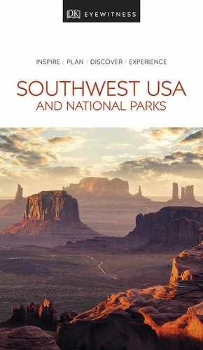
t A hiker enjoying the view from an overlook in Dead Horse Point State Park
The high mesa of Dead Horse Point lies just outside the entry to the Island in the Sky of Canyonlands National Park. Unforgettable views of the Colorado River and the maze of deep canyons , formed by millions of years of geologic activity, are a high point here.
According to legend, this park owes its name to the fact that it was once used as a natural corral for wild mustangs. A group of horses not chosen for taming were once left in this dry site for some unknown reason, eventually dying of thirst within sight of the Colorado River far below. The park also features several short hiking trails that follow the cliff edge, including a paved trail, offering variations on the truly amazing view.
The drama of this place has not been lost on Hollywood. Famous as the spot where Thelma and Louise drove off the edge in the 1991 film of the same name, these cliffs were scaled by Tom Cruise at the beginning of Mission: Impossible 2 (2000).
In 1952 a local prospector discovered the first of several major uranium deposits outside Moab. Overnight, the town became one of the wealthiest communities in America. When the uranium market declined in the 1970s, Moab was saved by tourism and its proximity to Arches and Canyonlands national parks.
Today, Moab is one of the top destinations for lovers of the outdoors. Mountain bikers come here to experience the famous Slick Rock Trail and the challenging ride to Moab Rim, a strenuous trail of about 10 miles (16 km). There is also a vast choice of hiking and 4WD routes taking in some of this region’s fabulous landscapes.
Matheson Wetlands Preserve off Kane Creek Boulevard has 2 miles (3 km) of hiking trails along a riverside wetland that is home to birds and wildlife.
White water rafting, paddleboarding, and kayaking on the Colorado River are other popular activities here.
With its mild, pleasant climate and Wild West feel, the town is popular with second-home owners and has a good selection of shops, restaurants, and galleries.
"
Matheson Wetlands Preserve
⌂ Off Kane Creek Blvd § (435) 259-4629 # Dawn–dusk daily
Did You Know?
The name “Moab” comes from an ancient biblical kingdom.
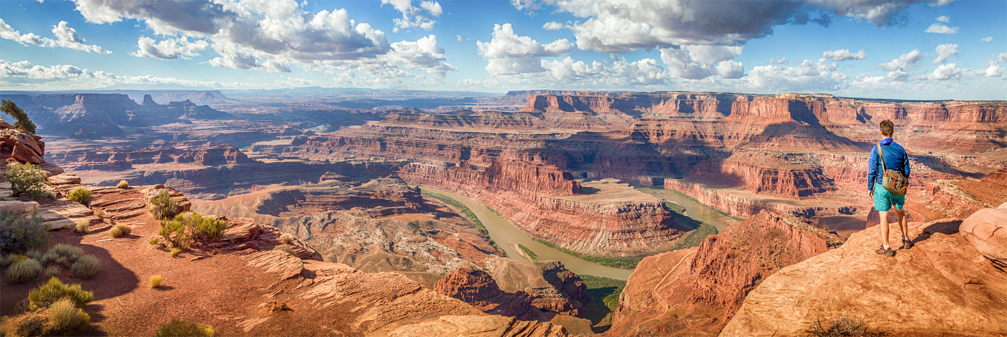
t Tackling the rapids of the notoriously wild Green River in a rowboat
Located in a broad, bowl-shaped valley, the town of Green River grew around a ford of the wild river of the same name in the 19th and early 20th centuries. Primarily a service town, it is also a launching spot for those braving the white water of the Green and Colorado rivers.
It was from here that the explorer and ethnologist John Wesley Powell began his intrepid exploration of the Colorado River and Grand Canyon in 1871. The expedition resulted in the creation of the first maps of the area. The John Wesley Powell River History Museum has about 20,000 sq ft (1,860 sq m) of displays tracing the history of the area’s exploration and also includes a film about Powell’s expedition.
" '
John Wesley Powell River History Museum
⌂ 1765 E Main St # Apr–Oct: 9am–7pm Mon–Sat, noon–5pm Sun; Nov–Mar: 9am–5pm Tue–Sat ¢ Public hols ∑ johnwesleypowell.com
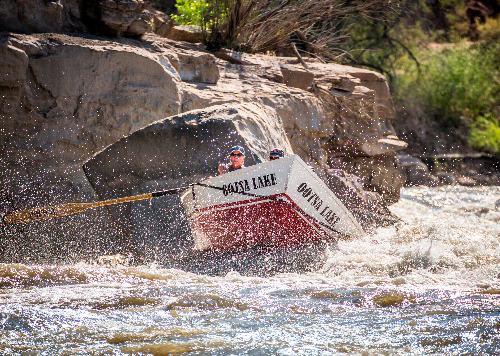
t The striking sandstone formations of Goblin Valley State Park
The “goblins” of Goblin Valley State Park are a group of mushroom-shaped rocks, or hoodoos, intricately carved by erosion. Visitors are free to wander among these rocks, which are up to 10 ft (3 m) in height. Two paved and several unpaved trails lead down to the valley floor.

Insider Tip
State Park Fees and Passes
Like the national parks, most state parks charge a day-entry fee. If you are planning to visit several parks, check to see if they offer passes for unlimited admission. Camping fees are extra.

t Jacob Hamblin Arch in the Grand Staircase–Escalante National Monument
Established by President Clinton in 1996, the Grand Staircase-Escalante National Monument encompasses 1,570 sq miles (4,066 sq km) of rock canyons, mountains, and high desert plateaus. It was named for the four cliff faces called Vermilion, Grey, White, and Pink, raised 12 million years ago, that build in tiered steps from Bryce Canyon to Grand Canyon across the Colorado Plateau.
The Bureau of Land Management intends to preserve the area’s wild state. It has declated that no new roads, facilities, or campgrounds will be built here.
The spectacular beauty of the monument is best explored on scenic drives combined with day-long hikes. Highway 89 follows the park’s southern boundary, in places hugging the base of the towering Vermilion cliffs.
Partly paved, the Burr Trail is one of the world’s most famous hairpinned roads. It winds through the Grand Staircase-Escalante National Monument past some of Utah’s most dramatic and beautiful scenery. A 40-mile (65-km) stretch follows Deer Creek, rising through the winding red-rock maze of Long Canyon. At the canyon’s end, the view opens out to reveal the pristine valleys of the Circle Cliffs and Capitol Reef. The trail crosses Capitol Reef as an unpaved road before reaching Bullfrog Marina at Lake Powell and is passable only by 4WD, high-clearance vehicles in dry weather.

Hidden Gem
Lower Calf Creek Falls
This waterfall, a 126-ft (38-m) plume that drops past lush gardens into an emerald-green pool, can be accessed via a trail that begins at Calf Creek Campground, off Hwy 12 near Boulder.
In 1879 a group of 230 Mormon settlers headed out from Panguitch, hoping to create a new settlement in southeastern Utah. They were brought to a halt by the yawning 2,000-ft- (610-m-) deep abyss of Glen Canyon. Undeterred, they dynamited a narrow hole through a wall of rock and constructed a primitive road down the sheer sides of the canyon. Lowering their wagons and cattle down the path by ropes, they finally reached the bottom, only to repeat the whole process in reverse to ascend the far side. They finally founded the town of Bluff in 1880.
Their original route, Hole-in-the-Rock Road, offers a trip through the wild interior of the Grand Staircase-Escalante National Monument. The road is rough in places, but passable. Intrepid hikers can explore Peekaboo and Spooky slot canyons, two slot canyons barely one foot (30 cm) wide in places. A 4WD vehicle is needed to cross the last 6 miles (10 km) to the pioneers’ “Hole in the Rock,” a 50-ft (15-m) slit that offers views of Lake Powell.
The tiny town of Boulder is home to the Anasazi State Park, which offers restored ruins and a museum detailing the history of the Ancestral Puebloans, who lived here between AD 1050 and 1200. Before Highway 12 was built, Boulder was virtually isolated and was the last town in America to receive its mail by pack mule. Today, it makes a welcome rest stop along Highway 12, which connects Highway 89 and Capitol Reef National Park. This road has some of the most spectcular and diverse landscapes found along any road in the USA.
Between Escalante and Boulder, Highway 12 winds through a landscape of vividly colored, towering rock formations and twisting canyons. Just before Boulder, the road offers white-knuckle excitement as it traverses the Hogsback, a knife-edge ridge of rock with steep drops on either side. Beyond Boulder, Highway 12 climbs to the 9,400-ft- (2,865-m) summit of Boulder Mountain.
A few miles east of Bryce Canyon and 9 miles (14 km) south of Highway 12, Kodachrome Basin State Park features 67 freestanding sand pipes, or rock chimneys. They formed as geyser vents millions of years ago, when the area is said to have resembled the geothermal terrain of Yellowstone National Park. The park was christened in 1948, when a National Geographic photographic expedition named it for the film they used to capture its multicolored monoliths set against the bright blue sky. Hiking trails of varying difficulties lead to outstanding vistas.
Experience Southern Utah
Slot Canyons
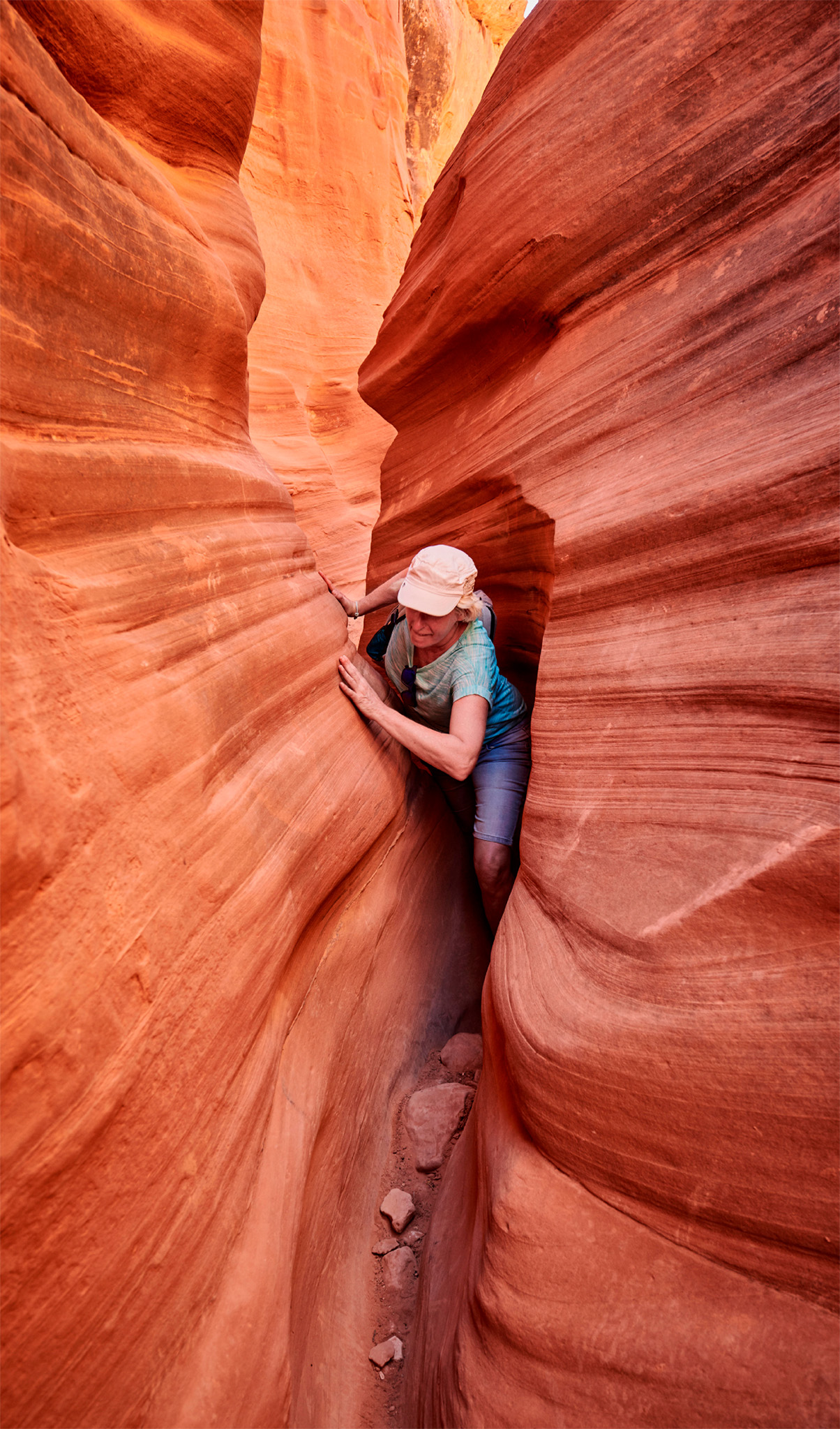
The Southwest is famous for its slot canyons. These deep gorges, just a few inches wide in spots, are formed when water etches its way through soft rock, carving out slender passageways. To Native Americans, slot canyons were spiritual places. They make amazing hiking routes, but the threat of flash flooding also makes them dangerous if rain is forecast.
Founded in 1851 by Mormons, this town developed as a center for mining and smelting iron in the latter part of the 19th century. Today, it offers hotels and restaurants within an hour’s drive of Zion National Park.
In town, the Frontier Homestead State Park Museum pays tribute to the indomitable and pioneering spirit of the early Mormons. It features an extensive collection of more than 300 wagons and early vehicles, including an original Wells Fargo overland stagecoach.
Cedar City’s Shakespeare Festival, which runs annually from late June to mid-October, is staged in a replica of London’s neo-Elizabethan Globe Theatre and attracts large audiences from the area.
"
Frontier Homestead State Park Museum
⌂ 635 N Main St § (435) 586-9290 # Jun–Aug: 9am–6pm daily; Sep–May: 9am–5pm Mon–Sat ¢ Jan 1, Thanksgiving, Dec 25

t Sunset over snow-covered cliffs at Cedar Breaks National Monument
Around 20 miles (32 km) east of Cedar City, along Highway 14, Cedar Breaks National Monument features a spectacular geologic amphitheater of vibrant pink and orange limestone cliffs, topped by deep green forest. Carved by erosion, sculpted columns rise in ranks of color, and resemble a smaller, less-visited version of Bryce Canyon. The area remains open to crosscountry skiers in winter. In summer, Cedar Breaks is covered with a stunning display of colorful wildflowers. An annual wildflower festival is held in July.
This small town was named for Fort Kanab, established in 1864 but abandoned only two years later following frequent Indian attacks. Mormon settlers founded the town in 1874. Its main purpose today is to offer reasonably priced food and accommodations to vacationers traveling between Grand Canyon, Zion, and Bryce Canyon national parks.
Often referred to as the “gateway to Lake Powell,” Kanab is also known as Utah’s “Little Hollywood,” a reference to the hundreds of movies and TV shows that have been filmed in and around the town, from Butch Cassidy and the Sundance Kid (1969) and The Outlaw Josey Wales (1976) to Planet of the Apes (1968 and 2001) and Mission: Impossible 2 (2000). Details of film sets open to the public may be obtained from the visitor center.
Did You Know?
Cedar Breaks’ Paiute name, “u-map-wich,” means “place where rocks slide down constantly.”
About 10 miles (16 km) west of Kanab, the Coral Pink Sand Dunes State Park is a sea of ever-shifting pink dunes that cover more than 5.8 sq miles (15 sq km). This harsh desert landscape was created when wind eroded the rich red sand-stone cliffs surrounding the site, slowly depositing sand in the valley below. Interpretive signs relate the story of the dunes’ geological formation. A path leads out into the dunes, where you can enjoy the thrill of sliding down them. The park is a popular with riders of ATVs (all-terrain vehicles) and dune buggies.
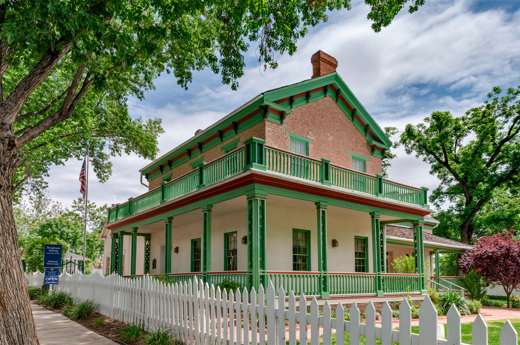
t Brigham Young Winter Home Historic Site, the former Mormon leader’s residence in St. George
Established in 1861 by Mormons, the town of St. George has since experienced a population boom as retirees from all over the US discovered its mild climate and tranquil atmosphere. The towering gold spire that can be seen over the town belongs to Utah’s first Mormon Temple, finished in 1877. A beloved project of Mormon leader and visionary Brigham Young (1801–77), it remains a key site. Although only Mormons are allowed inside the temple, the visitor center, which relates its history, is open to all visitors.
St. George’s association with Brigham Young began when he built a winter home here in 1871. While he and his family lived here he continued his work of directing the affairs of the Church of Jesus Christ of Latter-Day Saints. The elegant and spacious Brigham Young Winter Home Historic Site is now a museum and has preserved much of its first owner’s original furnishings.
" '
Brigham Young Winter Home Historic Site
⌂ 67 West 200 North St § (435) 673-2517 # Apr–Sep: 9am–7pm Mon–Fri, 1–7pm Sun; Oct–Mar: 9am–5pm Mon–Fri, 1–5pm Sun
Insider Tip
Cycling to Snow Canyon
Snow Canyon State Park lies 5 miles (8 km) northwest of St. George on Highway 18. It offers hiking trails that lead to volcanic caves and million-year-old lava flows. A paved bike path leads through the park and back to town.
The Mormons
The Church of Jesus Christ of Latter Day Saints was founded by Joseph Smith (1805–44), a farm worker from New York State. In 1820 Smith claimed to have had visions of the Angel Moroni. The angel led him to a set of golden tablets, which he translated and later published as the Book of Mormon, leading to the founding of the Mormon church. This new faith grew rapidly but attracted hostility because of its political and economic beliefs, and because it practiced polygamy. Seeking refuge, the Mormons moved to Illinois in 1839.

t A Mormon pioneer family in front of their log cabin in the Great Salt Lake Valley in the late 19th century. Today, about 55 percent of Utah’s citizens are Mormons.
The Trek West
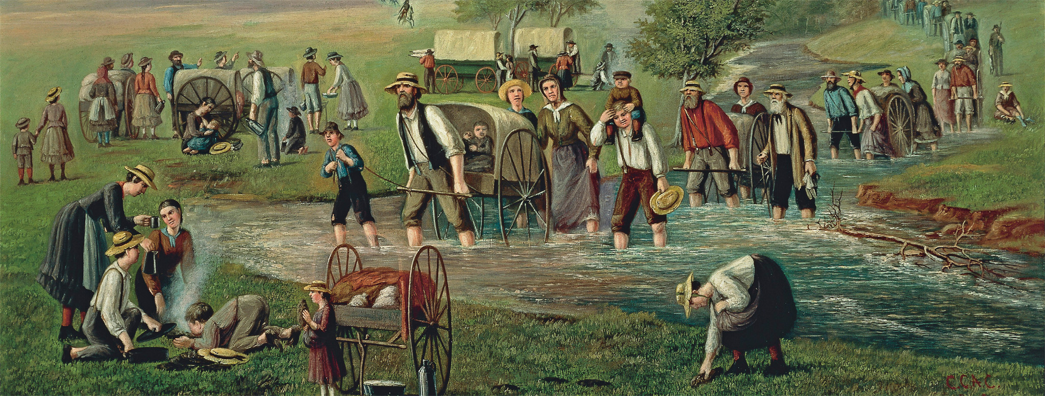
t Pilgrims on the migration from Illinois to Utah between 1846 and 1847
After Smith was killed by an angry mob in 1844 leadership passed to Brigham Young. In 1846, Brigham Young led a band of Mormons west from Illinois in the hope of escaping persecution and founding a safe haven in Salt Lake Valley. Young wished to find “a place on Earth that nobody wants.” The pioneers traveled across bleak prairies and over mountains in primitive wagons, braving the fierce winter and summer weather. Pilgrims rode or walked for a year, arriving in Utah in July, 1847.
Salt Lake City was painstakingly laid out in a grid system over the unpromising, and previously unsettled, landscape of Utah’s Salt Lake Basin. The grid ensured wide streets, decent-sized houses, and enough land that each family could be self-sufficient. After they had established themselves in Salt Lake Valley, church members fanned out across the west. By 1900, many agricultural colonies and more than 300 towns had been founded. One of these colonies was in Las Vegas, where 30 Mormons, sent by Brigham Young, built a mission and a small fort.
The St. George Utah Temple was constructed under the aegis of Brigham Young. For the 15 million Mormons worldwide, it is a potent symbol of a faith based on work, sobriety, and cooperation, with the emphasis on humanitarian service. Mormon missionaries preach their faith throughout the world and church membership continues to grow.
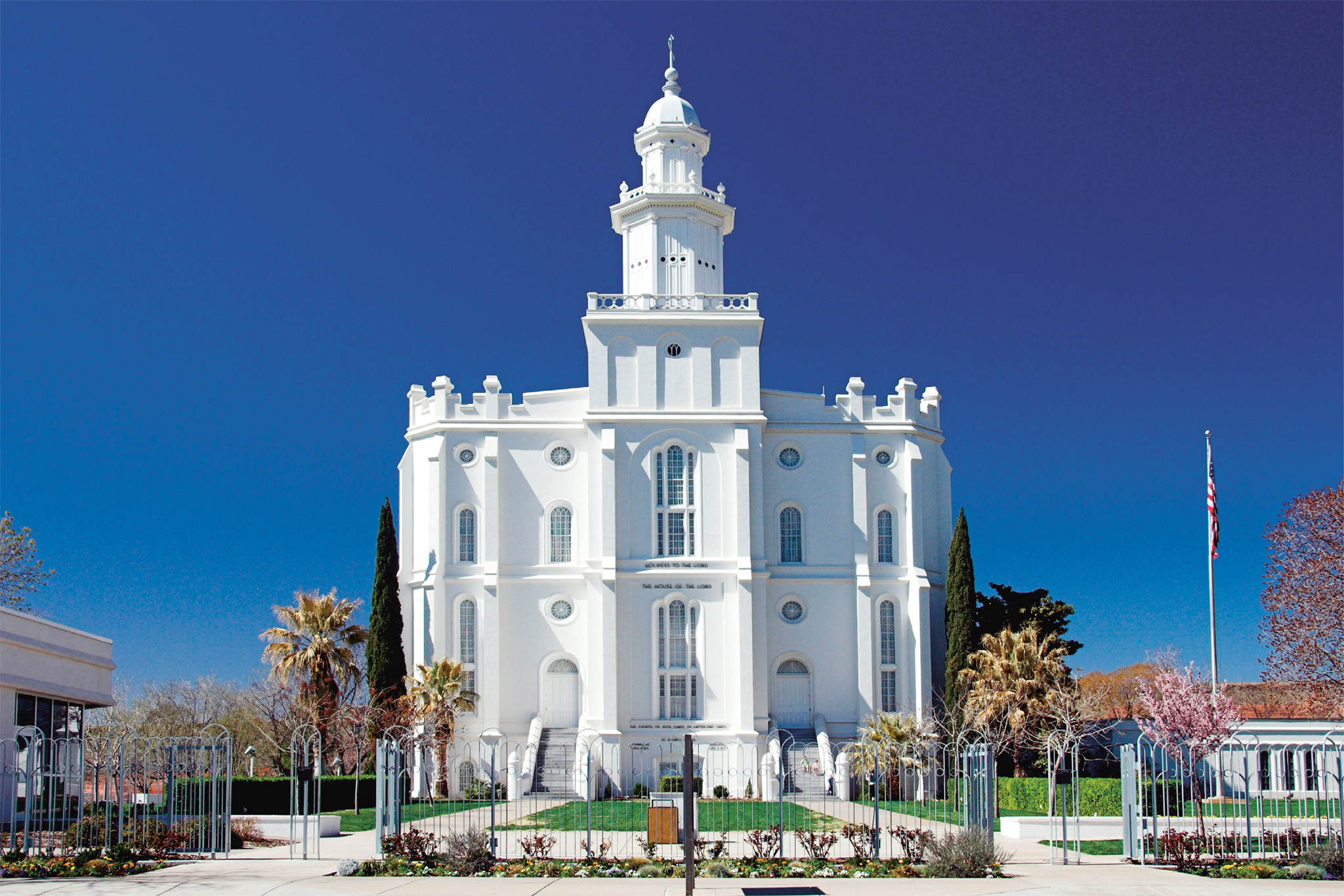
t The St. George Utah Temple, completed in 1877, after the migration west
Did You Know?
Mormonism’s most controversial practice, polygamy, was outlawed in 1890.
Experience Southern Utah
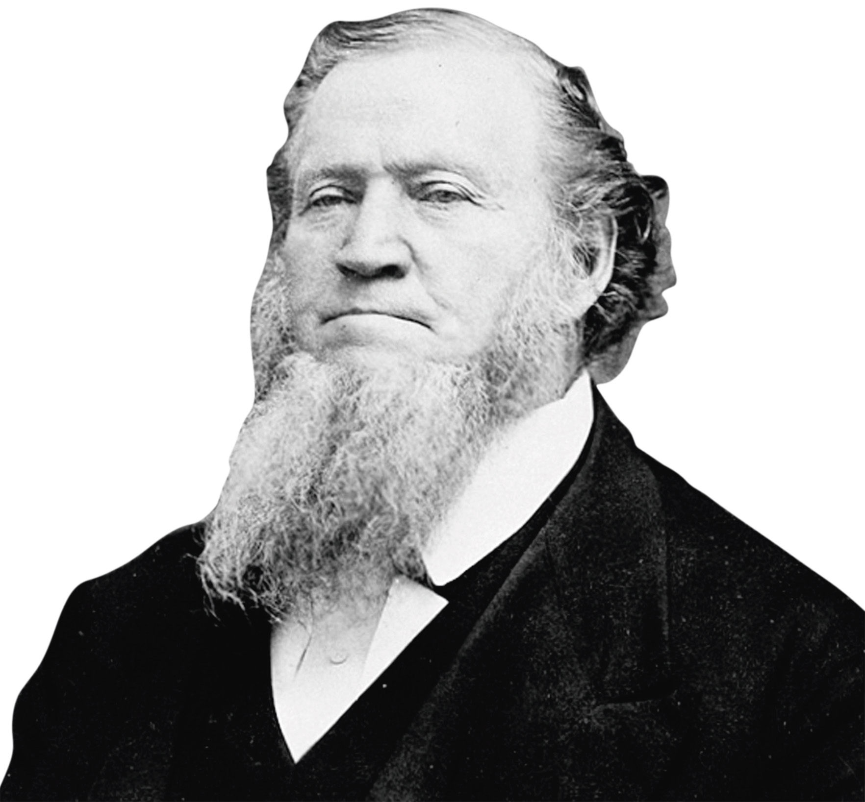
Brigham Young
Born in Vermont in 1801 of a Protestant family, Brigham Young, carpenter, painter, and glazier, joined the Mormons in Ohio in 1832. He took charge of the great migration west in 1846, arriving in Salt Lake City in 1847. In 1849 he established the territory of Deseret, which encompassed present-day Utah. The Mormon settlers turned the desert into fruitful farmland. Despite being removed from political office in 1857, Young was head of the Mormon church until his death in 1877.