Experience More

t Dam water and lush greenery outside the town of Dullstroom
The town of Dullstroom, set at a chilly altitude of 2,076 m (6,811 ft), houses the country’s highest railway station, and experiences winter temperatures that drop to -13° C (9° F). It is a top destination for fly-fishing, an activity focused on the Dullstroom Dams and Nature Reserve, on the town’s eastern outskirts, as well as various privately owned reservoirs. The Mavungana Flyfishing Centre has some excellent trout-stocked waters.
"
Dullstroom Dams and Nature Reserve
# Sunrise–sunset daily ∑ dullstroomonthedam.co.za
Mavungana Flyfishing Centre
# Daily ∑ flyfishing.co.za
Lydenburg (literally “Town of Suffering”) was founded in 1849 by the bereaved survivors of a malaria epidemic at Ohrigstad, a lower-lying Voortrekker settlement established four years earlier only 50 km (31 miles) to the north. Long before the Voortrekkers’ arrival, however, the area was part of an Iron Age settlement. Artifacts found here include the Lydenburg Heads, replicas of which are housed in the Lydenburg Museum. These large terracotta masks are believed to have been used in ceremonial rituals circa AD 700.
Some 53 km (33 miles) east of Lydenburg, Sabie is reached via the scenic Long Tom Pass, an old wagon road whose rocks still bear the marks of metal-rimmed wheel ruts. Sabie is surrounded by plantations of fast-growing exotic trees, established in the 19th century to provide timber for use in the local gold mines, and its Forestry Industry Museum is dedicated to wood and its many uses.
"
Lydenburg Museum
⌂ Long Tom Pass Rd § 013 235 2213 # 8am–4pm Mon–Fri, 8am–5pm Sat & Sun
"
Forestry Industry Museum
⌂ Ford St, Sabie § 013 754 2724 # 8am–4:30pm Mon–Fri, 8am–noon Sat
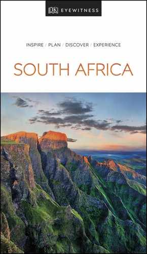
t A group of visitors admiring the dramatic Sudwala Caves, found just east of Mbombela
The low-lying provincial capital of Mpumalanga, rapidly growing Mbombela (a siSwati word meaning “Crowded Place”) is an important agricultural centre for oranges, mangoes, bananas, avocados and macadamia nuts. Formerly called Nelspruit, it has experienced a high level of industrialization since the 1990s, and has also grown in significance as a trade funnel on the main road and rail route between Gauteng and the Mozambican capital, Maputo.
The beautifully landscaped Lowveld National Botanical Garden, on the confluence of the Nels and Crocodile rivers, protects prehistoric cycads and other plants associated with the subtropical lowveld. Hippo and vervet monkey are present, along with 250 bird species. Chimp Eden, 15 km (9 miles) along the R40, is the setting of South Africa’s only chimpanzee sanctuary. Operated by the Jane Goodall Institute, it houses 30 chimps rescued from elsewhere in Africa in three large wooded enclosures overlooked by viewing platforms.
Alongside the N4, about 30 km (19 miles) east from Mbombela, guided tours into the impressive Sudwala Caves lead through cool subterranean passages past beautiful limestone formations to a natural dolomite chamber that can seat 500.
To the south of Nelspruit, Barberton Museum was established in 1883 to service a short-lived gold rush that led to it becoming the first stock exchange in the former Transvaal Republic. It sits below the Makhonjwa Mountains, whose 3.5-billion-year-old rocks comprise the planet’s oldest exposed strata. It has an excellent history and geological museum, and several architectural relicts of its Victorian heyday survive. Another highlight is the black-and-white photo display of the town’s development.
Lowveld National Botanical Garden
⌂ Madiba Drive § 013 752 5531 # Apr–Aug: 8am–5pm daily; Sep–Mar: 8am–6pm daily
' -
Chimp Eden
⌂ Turn Off 47, R40 ∑ chimpeden.com
'
Sudwala Caves
⌂ R539 # 8:30am– 4:30pm daily ∑ sudwalacaves.co.za
Barberton Museum
⌂ Crown St § 013 712 4208 # 9am–4pm daily

Hidden Gem
Screaming Monster
Keen runners should check out the annual Race of the Screaming Monster – a unique route that enters the Sudwala Caves. There are various lengths, so all ages can take part.
EXPERIENCE Limpopo, Mpumalanga and Kruger
|
Eat Breezy Dullstroom is a great place to break for lunch when driving between Gauteng and Kruger. Fresh trout is the local speciality. Mrs Simpson’s Restaurant ⌂ 94 Teding van Berkhout St § 013 254 0088 Coachman Restaurant ⌂ 89 Naledi Dr ∑ royalcoachmandullstroom.co.za Duck & Trout ⌂ Naledi Dr § 013 254 0047 Harrie’s Pancakes ⌂ Naledi Dr § 013 254 0801 |
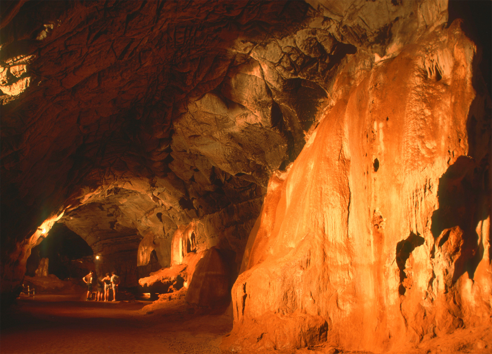
t The sun setting over the spectacular cliffs and winding waters of the Blyde River Canyon
The fast-flowing Blyde River has, over the centuries, carved its way through 700 m (2,300 ft) of shale and quartzite to create a scenic jumble of cliffs, islands, plateaus and bush-covered slopes that form a 20-km (12-mile) canyon. At the heart of this canyon lies the Blydepoort Dam.
Blyde means “river of joy”, and the river was named when Voortrekker Hendrik Potgieter and his party returned safely from an expedition to Delagoa Bay (Mozambique) in 1844. The abundant flora in the canyon ranges from lichens and mosses to montane forest, orchids and other flowering plants.
Protecting the area is the Blyde River Canyon Nature Reserve. A 300-km (186-mile) circular drive from Graskop via Bosbokrand, Klaserie, Swadini and Bourke’s Luck affords panoramic vistas of the escarpment rising above the plains, the Blydepoort Dam and the breathtaking view deep into the canyon itself. There are several overnight trails and short walks, and accommodation is available at Swadini, A Forever Resort. Set deep in the canyon on the shores of Blydepoort, this resort offers accommodation, a restaurant and a base for boating trips on the dam. The visitors centre and low-level view site have information on the dam and the Kadishi Falls, the world’s largest active tufa (calcium carbonate) formation. There is also a Blyde Canyon sister resort.
The area has many stunning natural attractions, including the Three Rondaevls. Resembling the traditional cylindrical huts of the Xhosa or Zulu, these three hills were shaped by the erosion of soft rock beneath a harder rock “cap” that eroded more slowly. The capping of Black Reef quartzite supports a growth of evergreen bush. The Three Rondavels is one of three sites that can be viewed from the road that overlooks the canyon – the other two are World’s End and Lowveld View.
Elsewhere, grit and stones carried by the swirling waters at the confluence of the Blyde (“joyful”) and Treur (“sad”) rivers have carved the extraordinary Bourke’s Luck Potholes. The name “Bourke’s Luck” comes from Tom Bourke, a prospector who worked a claim here in the vain hope that he would find gold. The visitor centre includes an exhibition outlining the geological history of the area.
The Panorama Route – an 18-km (11-mile) stretch of the R534 that loops along the top of the cliff at the very edge of the escarpment – is a scenic marvel. God’s Window and Wonderview may sound like purely fanciful names, but they are more than justified by the breathtaking scenery. Also visible on the route is the Pinnacle, an impressive column of rock that appears to rise sheer from a base of evergreen foliage. An optical illusion seems to place it almost within reach. Exposed layers of sandstone show the rock’s sedimentary origins. It becomes clear that, even at this lofty height, the top of the escarpment was once covered by a primordial sea.
Swadini, A Forever Resort
⌂ On R531 ∑ foreverswadini.co.za
" -
Bourke’s Luck Potholes
⌂ On R531 § 013 769 8926 # 7am–5pm daily
Did You Know?
Blyde River Canyon is one of the biggest canyons in the world, and is also one of the greenest.

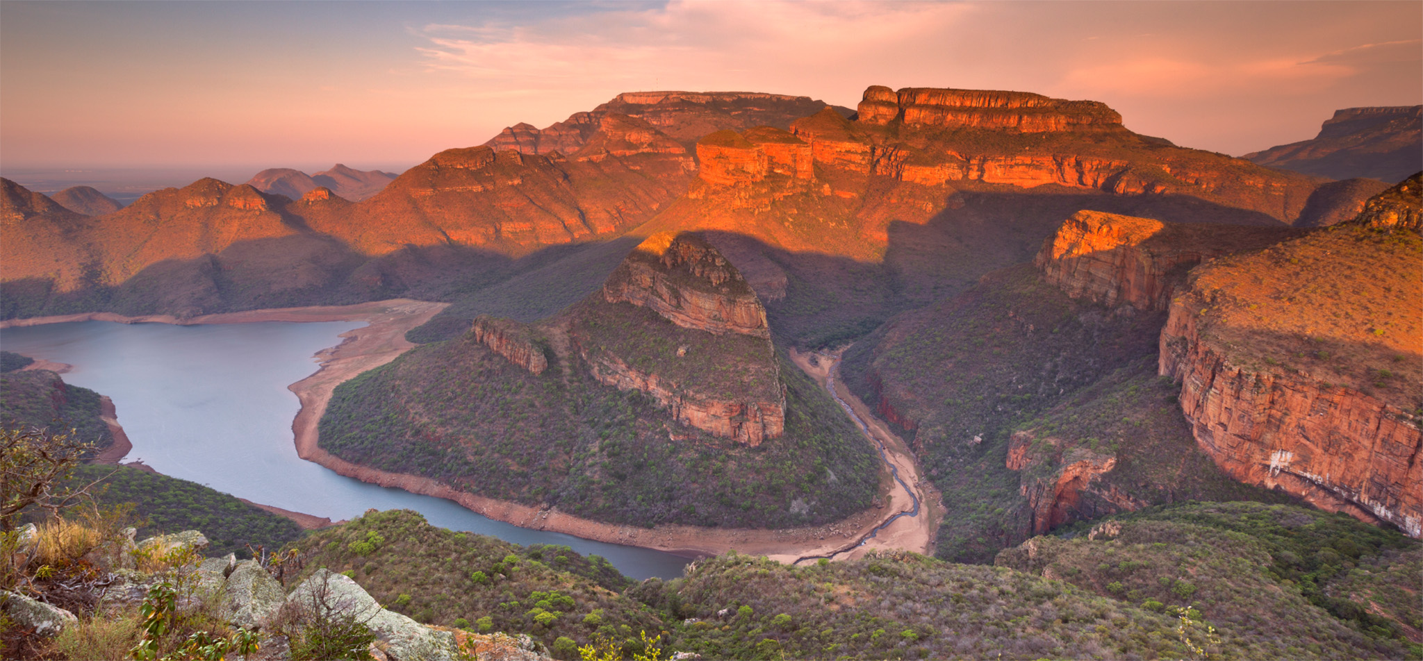
t A small safari party in Marakele National Park, Waterberg
The Waterberg massif is a 14,500-sq-km (5,598-sq-mile) UNESCO biosphere reserve, one of Africa’s two savannah biospheres. It rises to around 1,830 m (6,004 ft) some 200 km (120 miles) north of Gauteng. An attractive but rather unfocused region, it supports a mosaic of farms and private nature reserves, as well as the provincial Mokolo Dam, a popular site for water sports. A focal point is the 670-sq-km (259-sq-mile) Marakele National Park, which protects 90 mammal species including elephant, lion, leopard, black rhino, white rhino, giraffe and a wide variety of antelope. The proximity to Gauteng and the absence of malaria make it a popular choice with families.
A worthwhile stop en route between Gauteng and Water-berg is the Nylsvley Nature Reserve, which protects the Nyl Floodplain, one of South Africa’s most important water-bird sites. More than 375 bird species – almost a third of which are water birds – have been recorded in this small reserve, including the rare slaty egret and rufous-bellied heron. Walking trails also offer a chance to get close to non-dangerous large mammals; the reserve supports about 1,000 of these larger animals, such as giraffe, wildebeest and warthog.
-
Marakele National Park
⌂ Thabazimbi § 014 777 6928 # 7:30am–5:30pm daily
Nylsvley Nature Reserve
⌂ Mookgophong # May–Aug: 6:30am–5:30pm daily; Sep–Apr: 6am–6pm daily ∑ nylsvley.co.za
EXPERIENCE Limpopo, Mpumalanga and Kruger
|
Eat Canimambo Restaurante This family-run venue serves tasty Mozambican-style dishes such as bean stew, piripiri chicken and grilled prawns. ⌂ Cnr Louis Trichardt & Hoof sts, Graskop ∑ canimambo.za.net Kuka Café All-day breakfasts, pizzas, craft beers and tasty cocktails can be enjoyed at this bright Afro-chic café. ⌂ Perry’s Bridge Trading Post, Hazyview ∑ kukasoup.co.za Pioneer’s Butcher & Grill A modern steakhouse; meat is king, but their fish and vegetarian offerings are also strong. ⌂ Rendezvous Tourism Centre, Hazyview ∑ pioneersgrill.co.za The Greek Kouzina Genuine Greek cuisine, with an impressively lengthy meze selection. ⌂ Sonpark Centre, 7 Faurie St, Mbombela § 013 741 5371 |
Polokwane, a Sepedi name meaning “Place of Safety”, is the capital of Limpopo, South Africa’s most northerly province. Established by the Voortrekker leader Andries Potgieter in 1886, it was named Pietersburg (after Commandant-General Piet Joubert of the Transvaal Republic) until 2005. The Hugh Exton Photographic Museum, set in a late 19th-century Dutch Reformed Church, offers revealing insights into the town’s early history (particularly the Anglo-Boer War, when a British concentration camp housed 4,000 prisoners) through the thousands of images captured by its namesake between 1892 and 1945.
A good network of game-viewing roads and walking trails through the Polokwane Game Reserve on the southern outskirts of town provides an opportunity for close encounters with white rhino, giraffe and several other reintroduced large mammals.
Bordering the reserve, the Bakone Malapa Open-Air Museum offers informative guided tours through a faithful reconstruction of a traditional Pedi (North Sotho) homestead as it would have been in the 18th century. There are also demonstrations of local handcrafts.
Hugh Exton Photographic Museum
⌂ Church St § 015 290 2186 # 9am–3:30pm Mon–Fri
Polokwane Game Reserve
⌂ Silicon Rd § 015 290 2331 # May–Sep: 7am–5:30pm; Oct–Apr: 7am–6:30pm
'
Bakone Malapa Open-Air Museum
⌂ R37 § 073 216 9912 # 8am–3:30pm Mon–Fri
EXPERIENCE Limpopo, Mpumalanga and Kruger
|
Stay Marataba Safari Lodge Luxury canvas-and-stone suites, plus an infinity pool overlooking the plains. ⌂ Marakele National Park ∑ marataba.co.za Leokwe Rest Camp The largest camp in Mapungubwe, with comfortable self-catering chalets. ⌂ Mapunggubwe National Park ∑ sanpark.org Fusion Boutique Hotel Limpopo’s funkiest five-star accommodation. ⌂ 5 Schoeman St, Polokwane ∑ fusionboutiquehotel.co.za |
Tzaneen is a pleasant town set within an agricultural area that is associated with tea, tomato, mango and avocado production. It stands next to the pretty Tzaneen Dam and is surrounded by lush tropical forests.
The small Tzaneen Museum houses an interesting collection of ethnographic artifacts from all around Africa, including items associated with the Modjadji Rain Queen – a revered local monarch whose matrilineal line reputedly dates back to the 16th century but ended in 2005 with the untimely death of Makobo Constance Modjadji VI.
Some 30 km (19 miles) north of Tzaneen, tiny Modjadjiskloof – also referred to by its Afrikaans name Duiwelskloof (“Devil’s Gorge”) – has two main claims to fame. The misty forests of Modjadji Cycad Reserve support one of two extant populations of the eponymous cycad, a peculiar prehistoric palm-like tree that grows up to 12 m (39 ft) tall. Although partially topped over, the 1,700-year-old Sunland Baobab is reputedly the world’s tubbiest specimen of this magnificent species, with a circumference of 47 m (155 ft) and a drinks bar set within its central cavity.
Tzaneen Museum
⌂ 44 Agatha St § 083 280 4966 # 9am–4pm Mon–Fri, 9am–noon Sat
Modjadji Cycad Reserve
⌂ Off the Mohlakamosoma Rd § 015 307 3582 # 7am–4:30pm daily
Sunland Baobab
⌂ Leeudraai Rd # 7am–5pm daily

Insider Tip
Up in the Clouds
At 2,126 m (6,975 ft), the Wolkberg (Cloud Mountain) overlooking Tzaneen is the highest range in Limpopo. It supports a large tract of indigenous forest and harbours four endemic butterfly species.

t Mapungubwe National Park
Once the capital of an indigenous trade empire, Mapungubwe Hill was abandoned in the 13th century, when its inhabitants migrated north to establish the stone city of Great Zimbabwe. The hilltop citadel can still be visited on daily guided tours.
Inscribed as a UNESCO World Heritage Site in 2003, Mapungubwe today is the centrepiece of South Africa’s most northerly national park, inhabited by elephant, greater kudu and small populations of lion, leopard and cheetah.
The park’s Interpretation Centre provides an excellent overview of its history, and displays artifacts including a gold-plated rhino sculpture.
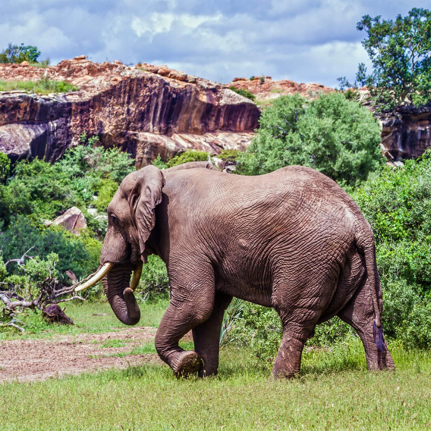
t Mapungubwe National park, home to a sizeable population of bush elephants