
Chapter Fifteen
Environmental Considerations
Chapter Outline
Learning Objectives
After reading this chapter, you should be able to:
- Explain the need for environmental protection.
- Identify potential environmental impacts of infrastructure projects.
- Compare current and historical engineering considerations of environmental impacts.
- Describe how environmental regulations “drive” infrastructure engineering.
- Describe how environmental complexity can lead to unforeseen effects of projects.
Introduction
Components of the natural environment and of the environmental infrastructure were discussed in Chapters 2 and 5 respectively. The need for a systems perspective was emphasized in Chapter 7. Here we will discuss the integration of the built and natural environments into one system, and investigate the potential environmental impacts of developing the civil infrastructure.
Dramatic changes have occurred over the last four decades with respect to scientific understanding, public opinion, and regulation of the environment. Compared to the nearly complete lack of regulations in the 1960s, engineers are now faced with a dizzying array of regulatory requirements at the local, state, and federal levels. These regulations are typically intended to protect the environment at a cost that society can reasonably bear. However, given the vast variability of environmental conditions, situations often arise wherein a required action is expensive but only marginally beneficial; in extreme cases, the action may even be detrimental to the environment.
Introductory Case Study: Wetlands
Wetlands are often perceived as a stumbling block to completing construction projects in a timely and cost-effective manner. Once thought of as wastelands and mosquito breeding grounds, wetlands were extensively filled and/or drained for construction projects. Large-scale filling of wetlands occurred during the building of cities such as Chicago, San Francisco (Figure 15.1), and Boston.

Draining of wetlands is accomplished by lowering the groundwater table using ditches or buried pipes (“drain tiles”), which is common for agricultural purposes, and accounts for the majority of wetland loss. It is estimated that less than one half of the pre-settlement (early 1800s) wetlands exist today nationwide, with some states having lost more than 90 percent of wetlands. Today, wetlands are valued by engineers as vital environmental features (Figure 15.2) and are highly regulated. We will discuss wetlands throughout this chapter, as well as many other environmental components.
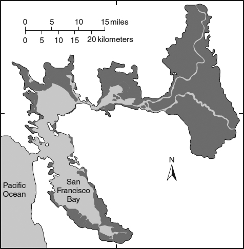
Figure 15.1 Historical Loss or Altering of Wetlands in the San Francisco Bay Region. It is estimated that approximately 95 percent of the original wetland habitat in the region has been lost or altered by filling and levees (dark shaded areas). As much as one-third of the losses were caused by filling for urban development. Much of the remaining wetland areas are protected, and significant restoration efforts are being undertaken.
Source: U.S. Geological Survey, redrawn from Atwater et al., 1977.
Environmental Protection
As highlighted in Chapter 2, Natural Environment, the three major components of the environment are land, air, and water. Within these components lies the supporting habitat for all forms of life.
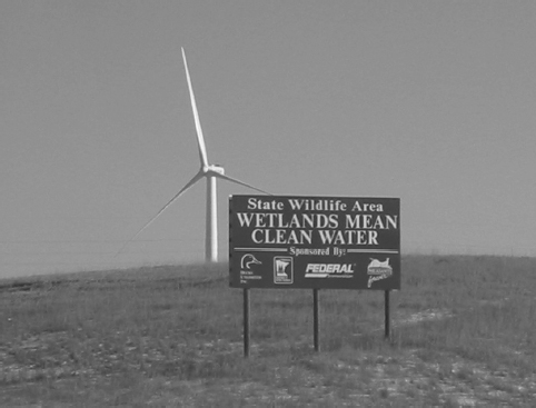
Figure 15.2 A Roadside Sign that Informs Drivers of Wetland Benefits.
Source: M. Penn.
Environmental awareness has increased dramatically in the last several decades, leading to increased public concern over the potential impacts of infrastructure projects. In step with this awareness, the number of environmental regulations has also increased. Most projects cannot begin construction until environmental studies and permit applications have been completed.
Nearly every construction activity or use of the built environment has some impact on the natural environment. Consider the following generic effects on the natural environment due to infrastructure development.
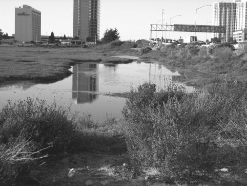
- Loss of habitat—The construction of infrastructure components, unless taking place in a previously developed area (infill), will require land. This land, whether a forest, a pasture, a park, or a riparian (riverbank) area, will previously have been home to a number of plants and animals. The development of the area often irreversibly alters these habitats or may fragment them so that habitats that were once connected are no longer connected (Figure 15.3).
Decreased biodiversity—As land in its natural state is converted to infrastructure components, a loss in biodiversity often accompanies the loss in habitat. A high level of biodiversity is desirable for many reasons. From a biological perspective, a diverse ecosystem is a healthy ecosystem, and is able to withstand and recover from a variety of diseases and extreme weather events. Also, a diverse set of plants and animals is necessary to ensure the productive cycling of nutrients in the environment.
Biodiversity is the diversity of plants and animals within a region. A rainforest or a northern hardwood forest has high biodiversity, while a golf course or cornfield has very low biodiversity.
- Increased contamination of air, water, and soil—Nearly all aspects of the built environment contaminate air, water, or soil. Examples include emissions from coal-fired power plants, the release of contaminants from a leaking landfill liner, emission of CO2 from automobile tailpipes, or release of zinc from the tires of automobiles.
Impacts on the natural hydrologic cycle—With many types of development, runoff from rain events increases as a result of the development, which leads to decreased recharging of groundwater and increased runoff and flooding potential downstream.
Figure 15.3 A Wetland and Surrounding Development of Filled Wetlands Along San Francisco Bay.
Source: Courtesy of R. Grossinger, San Francisco Estuary Institute.
Few rational people would argue that these impacts are desirable. However, there is considerable controversy over how widespread the negative impacts are; how harmful to the environment and to humans these impacts actually are; and to what extent the impacts should be regulated by the federal, state, and/or local government.
Case in Point: Benefits of Wetlands
Protection of wetlands leads to many benefits for society. Increased understanding of these benefits has led to rules that regulate filling or draining of wetlands. The following list, modified from a list provided by the Minnesota Department of Natural Resources, provides some benefits of wetlands:
- Erosion control. Wetland vegetation reduces erosion along lakes and stream banks by reducing erosional forces associated with wave action.
- Fisheries habitat. Many species of fish and shellfish utilize wetland habitats for spawning, food sources, or protection.
- Flood control. Wetlands can slow runoff water, minimizing the frequency at which streams and rivers reach catastrophic flood levels. Wetlands also provide storage of flood waters.
- Ground water recharge. Some wetlands serve as a source of groundwater recharge. By detaining surface waters that would otherwise quickly flow to distant lakes or rivers, the water can percolate into the ground and help ensure long-term supplies of ground water.
- Natural filter. By trapping and holding water, wetlands store nutrients and pollutants in the soil and vegetation, allowing cleaner water to flow in to the body of water beyond or below the wetland.
- Rare species habitat. More than 40 percent of threatened or endangered plant and animal species in the United States live in or depend on wetlands.
- Recreation/aesthetics. Wetlands are great places to canoe, hunt, fish, or explore and enjoy nature.
- Source of income. Wetlands provide economic commodities such as cranberries and fish and may add value to residential developments.
- Wildlife habitat. Many animals depend on wetlands for homes and resting spots. Amphibians, reptiles, aquatic insects, and certain mammals need wetlands as a place for their young to be born and grow.
- Education. Wetlands provide ideal locations for classroom ecological studies.
It is important to note that the above listed benefits are potential benefits. Individual wetlands may or may not provide these benefits.
Impacts on the environment can be minimized through sustainable1 design and construction of the infrastructure although few, if any, infrastructure projects can be completely free of environmental impacts. In some cases, infrastructure projects can have positive effects on the environment. For example, a wastewater treatment facility may discharge effluent that is cleaner (with respect to some pollutants) than the river to which it releases.
You should note that all impacts on the environment affect, directly and/or indirectly, human welfare. Contaminated air leads to respiratory and other illnesses in humans. Contaminated water ingested by humans can lead to any number of diseases and illnesses. Contaminated surface water may also lead to contaminated food sources such as fish and shellfish. Many possible pathways exist by which contaminants in soil can be ingested by humans: they may be ingested by animals that are eaten by humans, children may ingest the soil directly, contaminants may be taken up by plants that are consumed by people, and contaminants may make their way into the groundwater that serves as a drinking water supply. Polluted runoff leads to reduced recreational opportunities as beaches must be closed to swimming in response to high concentrations of pathogens. Alterations to the hydrologic cycle result in lowered groundwater levels, and thus higher costs to consumers as extracting and treating water becomes more expensive. Loss of habitat leads to loss of recreational opportunities (e.g., hunting, fishing, boating) and reduced biodiversity. There is substantial concern over decreased biodiversity; at the most basic level, it must be understood that humans are supported by the natural environment that is an extremely complex system of chemical, biological, and ecological interactions. A change to any component (e.g., species extinction) can have unforeseen cascading effects on humans.
Fish or Jobs?
In the industrialized Fox River valley of Wisconsin, when regulatory efforts to require treatment of industrial wastes before release to the river were first proposed, a common phrase used in opposition to these regulations was “What do you want: fish or jobs?” The implication of this question was that the additional cost of treatment of the industrial wastes would lead to increased production costs and fewer employment opportunities.

Debates over the required level of environmental protection are common. As with most considerations surrounding infrastructure projects, the answer is often not black or white, but rather in the gray area between the two extremes. It is likely that you know friends, family members, or neighbors with drastically differing views on the environment. At one extreme are those that believe natural ecosystems are more important than human welfare. At the other extreme are those who believe that the natural environment is to be completely controlled and dominated by humankind and as such, regulations are virtually unnecessary.
The nature of these debates continuously evolves over time. For example, as the population becomes increasingly urbanized (Figure 15.4), there is concern that the majority of Americans are “losing touch” with nature. Also consider that members of the environmentalist movement (derogatorily referred to as “tree huggers”) are increasingly joining forces with conservationists (e.g., hunter associations such as Ducks Unlimited and Pheasants Forever) to protect the natural environment. Additionally, when economic times are good, the environment is of greater concern to more people, while during recessions, environmental concern lessens (Figure 15.5). Additionally, affluent communities are often less tolerant of pollution, and wealthy nations typically have much more stringent environmental standards than developing nations.
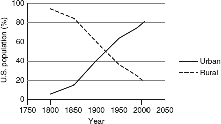
Figure 15.4 Percentage of U.S. Population Living in Urban and Rural Areas.
Data source: U.S. Census Bureau.
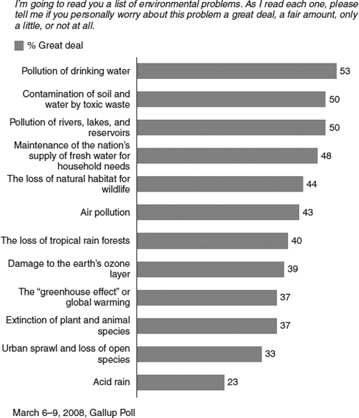
When polled about environmental concerns, Americans routinely rank drinking water pollution highest (Figure 15.6). Note that infrastructure projects directly or indirectly impact all of the concerns listed in Figure 15.6.
Figure 15.5 Changing Public Priorities of Two Major Issues. Note the decline in prioritization of environmental protection during the recessions of 2002–2003 and 2008–2010.
Data source: Pew Research Center, 2010.
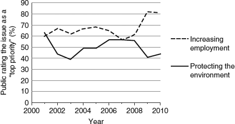
Figure 15.6 Polling Results of Public Environmental Concerns.
Source: Courtesy of Gallup.
Prior to 1970, the environment was often ignored in engineering decisions. The rapid industrial and population expansion preceding this period led to deplorable environmental conditions. In most cases, discharges of pollutants to the environment were unregulated. Many major rivers did not support healthy fish populations, and in some cases did not support any fish at all. Air quality in many areas significantly impacted human health, and thousands of toxic waste dumps existed across the country. The Clean Water Act and the Clean Air Act (with subsequent amendments) and countless other legislative acts have significantly improved the environment. Today, nearly all discharges to the environment are regulated. However, environmental degradation is rampant in developing countries, much as it was in the United States prior to the 1970s.
Rivers of Fire
Prior to enactment of the Clean Water Act of 1972, many rivers in the United States were “open sewers” containing partially or non-treated municipal wastewater and industrial wastes. River fires were not uncommon. Most often cited is the Cuyahoga River fire of 1969 in Cleveland, Ohio. The event captured international news coverage and became a symbol for poor environmental conditions in the United States. Petroleum slicks and floating debris were the fuel source for the fire. In the 1960s, the river was anaerobic (no oxygen present in the water) and essentially devoid of fish.

Today the Cuyahoga River supports forty species of fish and improved water quality has made the riverfront an attractive place for residential and commercial development. In “The Flats,” a popular nightlife district of renovated warehouses, many people are reminded of the past while relaxing after work or on the weekends (Figure 15.7).
 Picture of the Cuyahoga River Fire
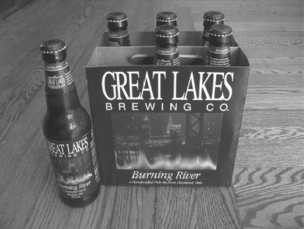
Figure 15.7 Burning River Pale Ale, a Nod to Local Environmental History.
Source: M. Penn.
Environmental Impacts
It is impossible to detail each and every potential environmental impact, but in this section we will illustrate representative impacts of infrastructure projects on the environment. Rather than classifying air, water, and soil impacts separately, we will highlight potential impacts of common infrastructure development activities.
LAND DEVELOPMENT
Developing land for industrial, commercial, or residential uses directly affects land through the alteration of surface topography, removal of topsoil, increased imperviousness by the addition of rooftops and paved surfaces, and loss of wildlife habitat. Increasingly, suburban development encroaches upon neighboring agricultural land, decreasing land available for production of food. Air quality may be affected by increased vehicle emissions, dust, CO2 emissions, and industrial air emissions. Water quality may be affected by stormwater runoff carrying particulates, toxins, and nutrients. Nearby surface waters may also be affected by increased flows during storm events, leading to more erosion and flooding. During construction, exposed land can erode and construction vehicles can “track” soil offsite. Additional environmental impacts include light pollution and noise pollution.
Natural Demolition
The extensive damage of hurricanes Katrina and Rita in 2005 resulted in an estimated 50 million cubic yards of waste debris in the state of Louisiana alone, with a similar amount generated in Alabama. As a point of reference, a large professional sports stadium would hold a volume of approximately 2million cubic yards. The sheer volume of waste, and its spatial distribution over thousands of square miles, created significant challenges for hauling and disposal, which continued for years after the hurricanes (requiring on the order of 1 million truck hauls). Neighboring states requested the waste (as a source of income) but wood debris could not be exported from the area in an effort to control the spread of a problematic insect, the Formosan termite. An additional challenge came from the fact that conventional landfills are not designed or regulated to accept hazardous materials. As a result, waste debris had to be manually screened for hazardous substances (e.g., medical waste, solvents, pesticides). The costs associated with the disposal of the debris are unknown, but is on the order of billions of dollars.

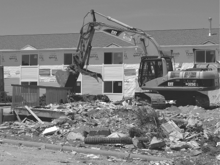
BUILDING DEMOLITION
The demolition of buildings and other structures (e.g., sports stadiums) results in the generation of airborne particulates and the potential release of other hazardous compounds such as asbestos and mercury, requiring abatement. If not recycled, large volumes of waste materials are generated and must be landfilled (Figure 15.8).
WASTEWATER TREATMENT
Wastewater treatment facilities (WWTFs) are designed to treat residential, commercial, and industrial wastewater before discharging to the environment. Many of the impacts listed previously for “land development” apply to WWTFs. Additionally, there is a direct impact on the surface water (e.g., a river) to which the treated wastewater is discharged. There are potential thermal impacts, as the temperature of the wastewater is typically higher than that of the receiving body of water. Also, if the wastewater originated as groundwater used for drinking water, the WWTF discharge will increase the flowrate of the river compared to if the river itself was used as the water source.
Today, WWTFs are regulated so that the treated wastewater, when mixed with the receiving water, will cause minimal adverse impacts on humans or wildlife. However, there are many unregulated substances such as pharmaceuticals for which there is increasing concern.
In some cases, WWTFs can affect air quality as well. Some industrial pollutants found in wastewater are volatile (i.e., they have a tendency to migrate from water into the air). If these chemicals are present in high enough concentrations, they may become a source of air pollution as they volatilize from treatment tanks that are open to the atmosphere.
Figure 15.8 Demolition Debris.
Source: M. Penn.
Video of Demolition of Thirty-Story Building
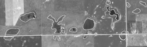
Figure 15.9 Roadways Crossing Wetlands (Wetlands Outlined). Prairie potholes (small lakes, ponds and wetlands) are common in eastern South Dakota, North Dakota, and western Minnesota. It is virtually impossible to route roads in this setting without affecting wetlands.
Source: U.S. Geological Survey/National Map.

HIGHWAYS
Highways require land space for travel lanes, shoulders, medians, and inter-changes that may take agricultural land out of production or eliminate CO2 sequestration (uptake) and wildlife habitat from forested land. In order to ensure safe driving conditions in sloped topography, extensive excavation of soil and/or rock is required, altering landforms. The alignment of the road in some cases results in the filling of wetlands (Figure 15.9). As with buildings and parking lots, runoff from the pavement carries pollutants, decreases infiltration of rain into the groundwater, and increases storm runoff. Highways may bisect wildlife habitat and lead to animal (and human) injury and mortality as a result of collisions. Approximately 200 human fatalities and 20,000 human injuries occur annually from wildlife-vehicle collisions. Nearly 40 percent of these collisions occur to people in the 15- to 24-year-old age group.
Photographs of Highways, Wildlife, and Mitigation Measures
Creative Roadway Lighting
A 1-mile stretch of Highway A1A in Boca Raton, Florida is now lit with LED lights embedded in the road surface rather than conventional overhead street lighting. Tests of this lighting scheme proved successful in minimizing the disorientation of hatchling loggerhead sea turtles, an endangered species. Importantly, the test project also showed no increase in automobile accidents, thus ensuring driver and pedestrian safety. Furthermore, public opinion was favorable toward the additional expense needed to protect the turtles.

Air pollution results from vehicle emissions and dust. Noise and light pollution also results from vehicles and roadside lighting. Highways are also corridors for additional residential, commercial, and industrial development leading to a myriad of potential impacts stated above.
DAMS
Dams are typically built for the benefits of hydropower, flood protection, and/or water supply. Dams directly affect the flow of rivers; changing the flow patterns can change river ecology. Dams can act as barriers to fish passage for seasonal migration or spawning. Land inundated by the reservoir formed behind the dam may act as a source of nutrients and other pollutants adversely affecting water quality. Accumulation of sediment, or siltation, occurs upstream of the dam due to lower velocity in the reservoir. Increased siltation also occurs downstream of the dam; with the dam in place, the peak flows are decreased due to the storage capacity of the reservoir, and these less violent flushes do not effectively resuspend and transport sediment. Water temperature increases in the reservoir and downstream of the reservoir during warmer weather, potentially affecting fish and other aquatic species. Increased evaporation occurs due to the increased surface area of the reservoir and increased temperature, leading to the loss of water for downstream users. Nutrients and toxins present in the river will accumulate in the reservoir. Some research suggests that decomposing organic material in the sediments accumulated behind dams is a significant source of methane, a greenhouse gas.
Case in Point: The Three Gorges Dam
In addition to many of the environmental impacts listed for dams, the recently constructed Three Gorges Dam in China (the world's largest concrete structure) is causing massive landslides from eroding banks of the newly inundated land. These landslides are displacing some farmers for a second time (those who were moved to higher ground because of the original displacement due to inundation by the reservoir). Some predict that the number of people ultimately displaced because of the dam may double due to landslides.

Additional concerns are based on a phenomenon termed reservoir induced seismic activity, whereby dams may cause earthquakes due to the extra water pressure (created by the newly added weight of the water accumulated behind the dam) in cracks in the ground under or near the reservoir. The increased pressure of the water in the cracks may “lubricate” or widen faults which were already under tectonic strain, but were previously prevented from slipping by the friction of the “unlubricated” rock surfaces.
The Good (Bad?) Ole Days
There are countless examples of infrastructure projects from “the good ole days” that have inadvertently had adverse impacts on the environment. A few examples are provided here.
The Everglades in the State of Florida is one of the world's truly unique ecosystems—historically including a massive wetland “river” estimated to be 50 miles wide. More than 50 percent of the original wetlands are no longer in existence, due to conversion to agriculture and urban land. Efforts to protect this resource have strengthened recently, but are often in conflict with increasing development demands for rapidly growing human resident and tourist populations in southern Florida. The population of southern Florida has increased by 25-fold, from 200,000 to over 5 million since 1930, a growth rate approximately ten times that of the United States. In 1947, Everglades National Park was formed and has tripled in size since initial establishment, now encompassing 1.4 million acres.

In 2000, the U.S. Congress authorized the Comprehensive Everglades Restoration Plan, one of the largest environmental restoration projects in history, with a 30-year time frame and a $10.5 billion budget. According to the Comprehensive Everglades Restoration Plan, “With no change the region soon will experience frequent water shortages. There will be continued degradation of the Everglades, coastal estuaries, fisheries and other natural resources. Flooding will become more frequent.”
The Comprehensive Everglades Restoration Plan
As part of the restoration plan, 240 miles (400 km) of canals and levees that were installed in the 1940s to control and divert water will be removed. In other words, this project may be described as a complex engineered effort to undo previous engineering work that failed to account for environmental impacts. Nearly 2 billion gallons per day of stormwater runoff will be treated to remove nutrients and other contaminants. This runoff will be stored and redirected to more closely resemble pre-settlement (i.e., natural) flow patterns to Florida Bay, a large, shallow and delicate ecosystem between the tip of the mainland peninsula and the Florida Keys (Figure 15.10). More than 200,000 acres of land have been purchased (50 percent of project goal) to control land use and attendant runoff. Measures will be taken to control invasive and exotic species. Habitat improvement through the use of prescribed burns that simulate natural wildfires will be employed.
Another example of undoing previous engineering work is dam removal. Several major dams have been removed and many more removals are under consideration to eliminate negative environmental impacts, especially in the Pacific Northwest where the purpose is to protect native salmon and trout.
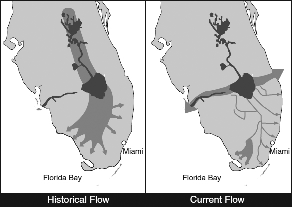
Figure 15.10 Historical and Current Water Flow Through the Everglades.
Source: Redrawn from USACE, 2010.

The Good Ole Days are Alive and Well
When presenting a design for a roof-top wind-powered electrical generator, a mechanical engineering student was asked “What about the potential impact of this device on birds?” Without hesitation, the student unfortunately responded “Birds? I don't care about birds.”
In November 2009, an agreement was signed by the U.S. Secretary of the Interior to raze four dams along the Klamath River, and is touted as the largest dam removal project in history. The deal was finalized after a decade of negotiations between Native American tribes, farmers, the fishing industry, the hydroelectric power company, and others. Additional pressure was brought to bear by the governors of Oregon and California and the Bush Administration after a commercial salmon fishery collapse in 2006. The power company that owned the dams was facing costly modifications to the dams to comply with the Endangered Species Act, and estimates suggested that dam removal was the least expensive option. With additional consideration of environmental and social benefits, the decision to remove the dams was made with support of shareholders (stock owners) of the hydroelectric company. A 3-year study will be conducted to evaluate the feasibility of dam removal, and removal is expected to begin in 2020 with an estimated cost range of $200 to $400 million.
The primary benefit of removing these dams will be the restoration of a 300-mile salmon run necessary for spawning and thereby maintaining one of the largest salmon fisheries in the contiguous United States. There is hope that substantial recreational tourism will provide additional economic benefit. Potential adverse impacts of the removal include the increased use of nonrenewable electricity generation to replace the renewable power generation lost, higher short-term electricity rates for users, and limited water availability for irrigation.
Environmental Regulations
In 1969, the National Environmental Policy Act (NEPA) was one of the first major environmental policies enacted, largely due to increased public outcry over projects that had historically been undertaken without regard for the environment. NEPA was designed to require the assessment of environmental impacts of federally sponsored projects and, importantly, to provide opportunities for public input. States now have similar policies for state-funded projects.
An Environmental Impact Statement (EIS) is an extensive process that typically requires coordination of several agencies. A common misperception is that an EIS is only concerned with the natural environment. In actuality, an EIS also encompasses economic and social considerations, which are discussed in the previous and following chapters, respectively. EIS reports are often massive, typically numbering several hundred pages, and sometimes thousands of pages as in the case of the EIS for “the Big Dig” in Boston. While daunting to students, researching an EIS for a large project can be very enlightening. An Environmental Assessment (EA) is a scaled-down version of an EIS, which typically documents an agency's decision to not perform a full-scale EIS because of a “Finding of No Significant Impact” (FONSI). It is very important to note that EIS's do not directly lead to the approval or denial of projects; that is, they are not “decision documents.” Rather, these reports only inform decision-makers and the public of the impacts of alternatives.
Sample EIS Report
The Emergency Wetland Resources Act of 1986 and subsequent regulations have curtailed wetland losses discussed in the introduction of this chapter. Before developing sites, developers must now identify whether or not wetlands exist. Identifying the boundaries of wetland areas is termed “delineating,” and is conducted by trained engineers and scientists (Figure 15.11). In many cases, the presence of wetlands is obvious (standing pools of water and cattails), but wetlands include areas with groundwater slightly below the ground surface as well as areas that only periodically flood or retain water. If wetlands are present at a site, several agencies may become involved (e.g., U.S. Army Corps of Engineers, U.S. Fish and Wildlife Service, state environmental protection agency). Regulatory options by these agencies include:
- denial of any filling of the wetland (i.e., the proposed site plan must be altered to avoid any ground disturbance within the delineated area, or in the extreme case, planned development of the site is abandoned);
- approval of filling of the wetland as long as the developer restores a nearby degraded wetland;
- approval of filling of the wetland as long as the developer constructs a new wetland nearby to replace the “lost” wetland; or
- approval of filling of the wetland without either of the two mitigation options listed previously.
Figure 15.11 A Stake Labeled “Wetland Boundary” Tied with Flagging Tape. Pink tape is routinely used to delineate the boundary between wetland and non-wetland areas of a construction site.
Source: M. Penn.

Permits and approvals for the second and third bullet items above, termed mitigation options, can potentially cause significant delays for construction projects, and must be accounted for in project timelines. In some cases, the presence of wetlands will be a primary factor considered in the decision of whether or not to purchase property for development. There have been many cases of illegal (i.e., unpermitted) development that occurred on wetlands out of ignorance, resulting in costly after-the-fact fines.
The Changing Basis for Decisions
The U.S. Army Corps of Engineers was asked to undertake a study of flood diversion for the Waccamaw River, which passes through Conway, SouthCarolina, after Hurricane Floyd caused damage in 1999. The proposed project involves constructing a canal to divert excess floodwaters away from Conway. The project had previously been studied in 1930, 1951, and 1965 and all studies concluded the canal to be infeasible. However, Conway hired the Corps of Engineers to look at the feasibility one more time. Again, the canal was found to be cost-prohibitive. According to Corps Spokesperson Glenn Jeffries, “The idea is getting a little worse each time we look at it, because we're looking at more environmental impacts and impacts on other areas as well that weren't necessarily a concern in the 1930s.”

Horry County, South Carolina Concept Study of a Flood Reduction Diversion Canal
Additionally, the quality of a wetland is an important factor in regulatory decisions. Some wetlands are of high quality, for example, by virtue of providing important habitat for rare species. Other wetlands may be of minimal environmental importance, such as a degraded wetland that consists of a monoculture of invasive, nuisance plants and that provides minimal flood protection.
Other major legislative actions such as the Clean Water Act, the Clean Air Act, the Water Pollution Control Act, the Comprehensive Environmental Response, Compensation, and Liability Act (Superfund), and the Resource Conservation and Recovery Act have dramatically changed the way that we manage wastes and led to the rapid expansion of the field of environmental engineering over the last several decades. New and pending regulations on carbon dioxide will have a significant impact on the planning, design, and management of infrastructure components and systems.
Environmental Complexity
Ecosystems are complex communities consisting of organisms and the natural environment upon which they depend. As a system, all components must be protected to ensure ecosystem function and health. Historically, environmental managers erroneously looked only for direct impacts on a desired “endpoint” (e.g., a game fish such as walleye). An infrastructure project such as a WWTF, marina, or bridge may not seemingly have a direct impact on game fish. However, if the project adversely affects their food sources (or their food sources' food sources), or their spawning habitat, game fish populations may decrease.
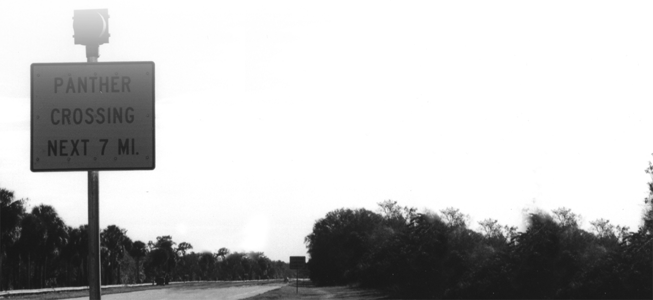
A key element of the previously mentioned Everglades management plan is the Florida panther, a subspecies of mountain lion, which once ranged in eight states over the entire southeast United States, but now has a range reduced to approximately 10 counties in southern Florida. It is considered one of the most endangered large mammal species in the world.
The current population is estimated at approximately 100 animals, and was thought to be as low as 30 in the early 1990s (Figure 15.12). The population decreased dramatically over the last century due to habitat loss, hunting, and bounties. With a small population, limited genetic variability also threatens the panther. Conversion of woodlands to agricultural grazing lands is the primary reason for habitat loss. While loss of habitat is most significant, degradation and fragmentation of remaining habitat also pose major threats to the panther's future. Urban sprawl has also contributed to habitat loss.
In 1958, the State of Florida declared the panther an endangered species. It is now federally listed as a critically threatened species. The preferred prey for the panther is whitetail deer, the population of which has also declined, for similar and other reasons. In areas with low deer populations, raccoons are increasingly important to the panther diet. However, raccoons feed on fish and crayfish, and as a result have elevated mercury content through bioaccumulation (Figure 15.13). This figure illustrates that the concentration of mercury in walleye is 1 million times greater than the concentration of mercury in phytoplankton.
Bioaccumulation is the process whereby contaminants in the environment are taken in by plants or animals and accumulate in higher members of the food chain.
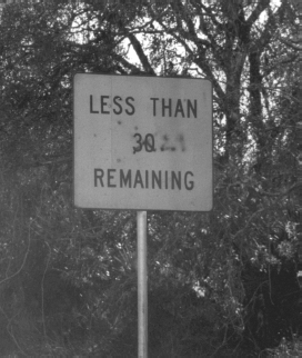
Figure 15.12 A Roadside Sign in the Everglades Indicating the Population of Florida Panthers in the Late 1990s. Note the vandalism of the sign in which the vandals used spraypaint to change the number remaining from 30 to 29.
Source: M. Penn.
Increased mercury levels in panthers may be linked to decreased health and reproductive success, but studies have not yet proved or disproved this hypothesis. This scenario linking the terrestrial and aquatic food chains demonstrates ecological complexity.
We also must be concerned with complexities of the physical and chemical cycling of pollutants in the environment. A pollutant discharged to the air may not remain there; it can end up in surface waters, in the fish that live there, and in the humans that eat the fish (recall the discussion on mercury in Chapter 12, Energy Considerations). Pollutants disposed on or in the ground may seep into groundwater and potentially contaminate drinking water wells or rivers and lakes. There are countless other examples.
In some cases, chemicals end up in places we wouldn't necessarily expect. For example, PBDEs (polybrominated diphenylethers) are flame retardants used on fabrics and furniture. Prior to recent phase-outs of their use, concentrations of PBDEs were increasing worldwide in human breast milk, seals, fish, and in virtually anything that has been analyzed for PBDEs. You might wonder how this contaminant is getting in the environment. Most likely, it is not in the environment due to direct releases by industry, but rather by emissions from solid waste incinerators, unregulated (“backyard”) trash burning, and by “dust” (fragments of fabrics from wear and tear). Like mercury (Figure 15.14), PBDEs accumulate in fish to thousands of times the concentration in the water. Moreover, there is uncertainty as to what the potential health impacts are from eating these fish, or for infants drinking breast milk, or for any other pathway. The government or PBDE industry never conducted studies to determine the health effects because people were not assumed to be eating their furniture and no one foresaw the other pathways by which PDBEs would enter the natural environment. While regulated in the European Union, most manufacturers in the United States have voluntarily chosen to use alternative substances for reducing fire risk in light of pending regulations at the federal or state level.
Figure 15.13 Bioaccumulation of Mercury in the Onondaga Lake (Syracuse, New York) Aquatic Food Chain. The levels in walleye (a highly desirable fish for consumption) are more than double the federal mercury concentration limit for safe consumption of 1 μg/g. Relative size of plankton are exaggerated as shown.
Source: Modified, with permission from Wiley, from Mihelcic, 1999.
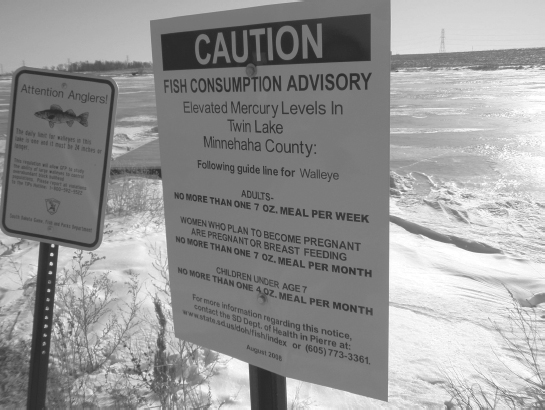
Figure 15.14 A Fish Consumption Advisory Sign Warning Anglers of Elevated Mercury Levels in Fish in Rural South Dakota.
Source: Courtesy of J. Stone.
Transportation Impacts on Panthers
Vehicle collisions have been one of the most significant sources of Florida panther mortality. Interstate 75, which bisects the Everglades region, was designed in some stretches with wildlife underpasses and fencing to reduce opportunities for panthers to cross over the highway. However with increased traffic, increased panther population, and only partial fencing (Figure 15.15), collision deaths (Figure 15.16) have increased and represent a loss of more than 10 percent of the entire population. Between 2007 and 2009, deaths due to collisions averaged 14 per year as compared to about 1 per year from 1978 to 1998.
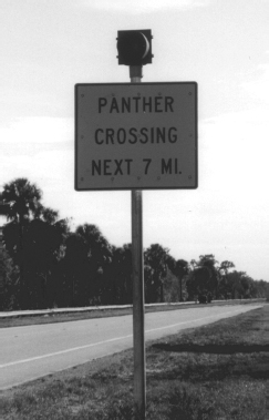
Figure 15.15 An Unfenced Portion of I-75 in the Everglades.
Source: M. Penn.
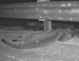
Figure 15.16 A Florida Panther Killed by a Vehicle Collision.
Source: Courtesy of the Florida Fish and Wildlife Conservation Commission/D. Land.
Outro
Development of our infrastructure affects the natural environment in many ways. Efforts to minimize environmental impacts are often driven solely by regulation, but arguably should be driven by sound economic, scientific, social, and ethical considerations.
Environmental aspects of infrastructure projects are quite controversial, scientifically, economically, and politically. However, our understanding of the environmental impacts of infrastructure projects is continually improving due to the establishment of long-term data sets, improved monitoring, and increased scientific knowledge of environmental complexities. These all provide the basis for better decisions. In future classes, you will learn methods to minimize the environmental impacts discussed in this chapter, while providing needed local, regional, national, or international infrastructure improvements.
chapter Fifteen Homework Problems
- 15.1 Using Figure 15.1, approximate the area (in square miles) of wetlands filled in the San Francisco Bay area.
- 15.2 Using Figure 15.13, how much greater is the mercury concentration in walleye compared to gizzard shad?
- 15.3 Why have cities such as San Francisco historically filled in their wetlands?
- 15.4 How does Figure 15.3 illustrate “habitat fragmentation?”
- 15.5 In what ways does land development affect the environment?
- 15.6 How will removal of dams on the Klamath River:
- help the environment;
- hurt the environment;
- benefit society;
- be detrimental to society?
- 15.7 How does bioaccumulation affect humans?
- 15.8 As noted in this chapter, many aquatic species have high mercury concentrations. What is the primary source of this mercury?
- 15.9 The State of Minnesota recently had a public education campaign stating “Eat smaller fish.” What is the basis for this advice?
- 15.10 Summarize the threats to the Florida panther.
- 15.11 Do you agree with the statement, “that the majority of Americans are ‘losing touch’ with nature”? If this statement is true, what are some implications for environmental decisions related to the infrastructure?
- 15.12 Explain how infrastructure projects affect each environmental impact listed in Figure 15.6. Limit your answer to two to three sentences for each impact.
- 15.13 During the 1960s and 1970s, Lake Erie was known as a “dead lake.” Why? What measures were taken such that it is no longer considered “dead?” Limit your response to one page.
- 15.14 How was the solid waste from the World Trade Center, destroyed by the 9/11 terrorist attacks, disposed of? Describe the process by which it was handled in one page.
- 15.15 Research a dam removal project not discussed in this chapter. Summarize the reasons for removal and public opinion toward the project. Limit your response to one page.
- 15.16 Locate a wetland of your choice (or of your instructor's choice) and summarize the environmental benefits, giving specific examples of benefits.
- 15.17 What other issues besides environmental protection become of lesser concern to the general public during economic recessions? Cite your references.
Key Terms
- bioaccumulation
- biodiversity
- environmental assessment (EA)
- environmental impact statement (EIS)
- mitigation
- reservoir induced seismic activity
References
Atwater, B. F., S. G. Conard, J. N. Dowden, C. W. Hedel, R. L. MacDonald, and W. Savage. 1977. “History, Landforms, and Vegetation of the Estuary's Tidal Marshes.” In: San Francisco Bay: The Urbanized Estuary. Investigations into the Natural History of San Francisco Bay and Delta With Reference to the Influence of Man, pp. 347-386. Pacific Division of the American Association for the Advancement of Science. http://www.estuaryarchive.org/cgi/viewcontent.cgi?article=1031&context=archive, accessed August 29,2011.
Mihelcic, J. R. 1999. Fundamentals of Environmental Engineering. Hoboken, NJ: John Wiley & Sons.
Minnesota Department of Natural Resources. Benefits of Wetlands. http://www.dnr.state.mn.us/wetlands/benefits.html, accessed August 29,2011.
Pew Research Center. 2010. “Public's Priorities for 2010: Economy, Jobs, Terrorism.” The Pew Research Center for the People and the Press. http://people-press.org/report/584/policy-priorities-2010, accessed August 29, 2011.
U.S. Army Corps of Engineers (USACE). 2010. “Water Flow Maps of the Everglades: Past, Present, Future.” http://www.evergladesplan.org/education/flowmaps.html, accessed August 29,2011.
U.S. Geological Survey. Coastal Wetlands and Sediments of the San Francisco Bay System: USGS Fact Sheet. http://pubs.usgs.gov/fs/coastal-wetlands/, accessed August 29, 2011.
1Recall from Chapter 13 (Sustainability Considerations) that sustainable engineering is concerned with minimizing environmental and social impacts.