Here it is, folks: the Maps that made international headlines.
When Apple brought its own Maps to the iPhone in 2012, the underlying databases had a lot of problems. They didn’t include nearly as many points of interest (buildings, stores, landmarks) as Google. Addresses were sometimes wrong. Satellite view showed bridges and roads melting into the sea. In a remarkable apology letter, CEO Tim Cook recommended using one of Maps’ rivals.
But some of Maps’ features are pretty great—and now that Maps is a Mac app too (Figure 18-18), there’s some handy synergy with the iPhone or iPad. You can look up an address on the Mac, and then wirelessly shoot it over to the phone for navigation in the car, for example. And Maps’ smarts are now wired into other OS X programs, like Calendar, Contacts, and Safari.
When you open Maps, you see a blue dot that represents your current location. You can manipulate the map in all the usual ways:
Zoom in or out using the keyboard (press ⌘-plus or ⌘-minus), the mouse (double-click to zoom in, add the Option key to zoom out—or just click the
 or
or  buttons), or the trackpad (pinch two fingers to zoom out, spread them to zoom in).
Scroll around the map using the keyboard (press the arrow keys), the mouse (drag), or the trackpad (swipe two fingers in any direction).
Rotate the map using the mouse (drag the small compass at lower right) or the trackpad (rotate two fingers). You can return the map to “North is up” by pressing ⌘-
 , by clicking the compass, or by double-tapping two fingers on the trackpad.
You can tilt into a 3-D view, which makes it look more like you’re surveying the map at an angle instead of straight down. You can do that with the mouse (click the
 ), keyboard (press ⌘-0), or the trackpad (press Option and drag with two fingers).
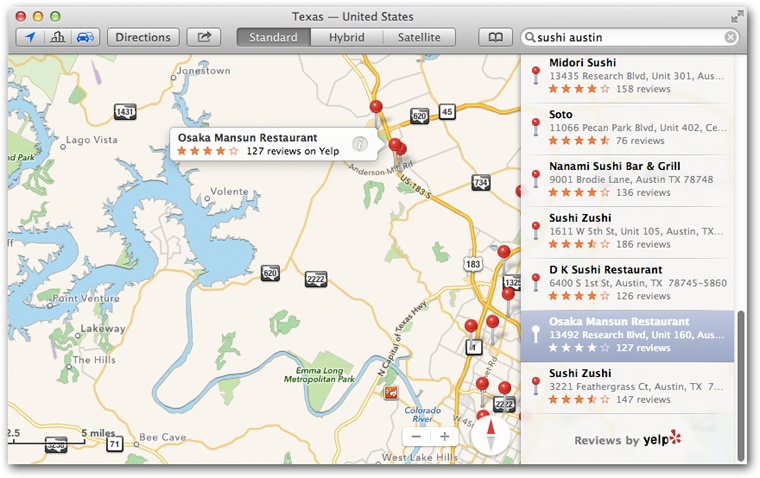
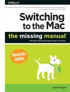
Figure 18-18. Maps lets you type in any address or point of interest and see it plotted on a map, with turn-by-turn driving directions, just like a $300 windshield GPS unit. It also gives you a live national Yellow Pages business directory and real-time traffic-jam alerts. You have a choice of a street-map diagram or actual aerial photos, taken by satellite.
At any time, you can click any of the buttons above the map for your choice of amazing map views: Standard (street-map illustration), Satellite (stunning aerial photos), or Hybrid (photos superimposed with street names).
There’s no guarantee that the Satellite view provides a very recent photo—different parts of the Maps database use photography taken at different times—but it’s still very cool.
Maps’ first trick is to show you where you are.
Click the ![]() button at the top left of Maps. When the button is blue, the Mac is showing you your location. (Click it to turn it black, which makes it stop showing your dot.)
button at the top left of Maps. When the button is blue, the Mac is showing you your location. (Click it to turn it black, which makes it stop showing your dot.)
You’re not always interested in finding out where you are; often, you know that much perfectly well. Instead, you want to see where something else is.
Click in the search box and type what you’re seeking. (If there’s already something in the box, click ![]() to clear it out.) Here’s what Maps can find for you:
to clear it out.) Here’s what Maps can find for you:
An address. You can skip the periods (and usually the commas, too). And you can use abbreviations. Typing 710 w end ave ny ny will find 710 West End Avenue, New York, New York. (In this and any of the other examples, you can type a Zip code instead of a city and a state.)
An intersection. Type 57th and lexington, ny ny. Maps will find the spot where East 57th Street crosses Lexington Avenue in New York City.
A city. Type chicago il to see that city. You can zoom in from there.
A Zip code or a neighborhood. Type 10024 or greenwich village.
A point of interest. Type washington monument or niagara falls.
A business type. Type drugstores in albany ny or hospitals in roanoke va. (Figure 18-18 shows this idea.)
When Maps finds a specific address, an animated, red-topped pushpin comes flying down onto its precise spot on the map. A bubble identifies the location by name.
Click outside the bubble to hide it. Click the map pin to bring the bubble back. Click Directions for instant driving directions.
Once you’ve found something on the map—your current position, say, or something you’ve searched for—you can drop a pin there for future reference. Choose View→Drop Pin. A blue pushpin appears. (You can drag the pin to move it, if your aim wasn’t exact.)
Red pushpins represent addresses you’ve looked up. And the tiny icons represent restaurants, stores, and other establishments in Apple’s (actually Yelp’s) database.
All of these pushpins and nano-icons are clickable. You get little labels that identify them. And if you click the ![]() button on a label, you open a details screen (Figure 18-19).
button on a label, you open a details screen (Figure 18-19).
Maps is also plugged into your Contacts list, which makes it especially easy to find a friend’s house (or just to see how ritzy his neighborhood is).
Instead of typing an address into the empty search bar, click the ![]() button next to it. You arrive at the Bookmarks/Recents/Contacts screen, which can save you a lot of typing.
button next to it. You arrive at the Bookmarks/Recents/Contacts screen, which can save you a lot of typing.
The list at left offers one-click access to Recents (locations you’ve looked up recently—on your Mac or your iOS gadgets), Bookmarks (locations you’ve bookmarked), and Contacts. Yes, your master address book (Contacts (Address Book)) is accessible here; you can search All Contacts or any one of your accounts.
When you click an entry in any of these lists, Maps drops a red, animated pushpin onto the map to identify that address.
That pushpin business also comes into play when you use Maps as a glorified national Yellow Pages. If you type, for example, pharmacy 60609, then those red pushpins show you all the drugstores in that Chicago Zip code. It’s a great way to find a gas station, a cash machine, or a hospital in a pinch. Click a pushpin to see the name of the corresponding business.
Figure 18-19. On the Details screen that sprouts when you click a red pushpin, buttons let you bookmark the spot, get directions, or add the information to Contacts. If the location is a restaurant or a business, you might strike gold: The details screen might offer several screens full of useful information, courtesy of Yelp.com. You’ll see customer reviews, photos, hours of operation, delivery and reservation information, and so on. Best of all, the ![]() button lets you share this location with other people—via AirDrop, email, text message, Facebook, or Twitter—or with yourself. In this example, “Goldie” is the name of an iPhone, one of three iOS devices that can accept location pointers from Maps on your Mac.
button lets you share this location with other people—via AirDrop, email, text message, Facebook, or Twitter—or with yourself. In this example, “Goldie” is the name of an iPhone, one of three iOS devices that can accept location pointers from Maps on your Mac.
As usual, you can click the ![]() button in the map pin’s label bubble to open a details screen. If you’ve searched for a friend, then you see the corresponding Contacts card. If you’ve searched for a business, then you get a screen containing its phone number, address, Web site, and so on; often, you get a beautiful page of Yelp information (photos, reviews, ratings).
button in the map pin’s label bubble to open a details screen. If you’ve searched for a friend, then you see the corresponding Contacts card. If you’ve searched for a business, then you get a screen containing its phone number, address, Web site, and so on; often, you get a beautiful page of Yelp information (photos, reviews, ratings).
Remember that you can click a Web address to open it or send the phone number to your phone to dial it. (“Hello, what time do you close today?”)
The Directions panel at right opens when you click any Directions button in Maps. It actually offers two search bars: Start and End. Plug in two addresses—the Start address may already say “Current Location”—and let Maps guide you from the first to the second.
Tip
If you click the ![]() button, you swap the Start and End points. That’s a great way to find your way back after a trip.
button, you swap the Start and End points. That’s a great way to find your way back after a trip.
When everything looks good, clicking Maps displays an overview of the route you’re about to follow. In fact, it usually proposes several different routes. They’re labeled with little tags that show how long they’ll take: “1 hr 9 min,” “1 hr 15 min,” and “1 hr 28 min,” for example.
If you click one of these tags, the top of the Directions panel lets you know the distance and estimated time for that option and identifies the main roads you’ll be on.
Click the Route label you want.
Now, nobody expects you to use your Mac as a portable GPS device. You’re not going to park it on your dashboard and have it tell you when to turn.
What you can do, though, is send your selected directions to an iPhone or an iPad and use that as your GPS. See Figure 18-19.
Or, if you’re just planning your trip, click any of the steps in the Directions panel; the map zooms in to that particular turn. Your route looks like it’s been drawn in with blue highlighter.
How’s this for a cool feature? Free, real-time traffic reporting. Just click the ![]() button. Now traffic jams appear on the relevant roads, for your stressing pleasure; orange dotted lines for slow traffic, and red ones for true stop-and-go nightmares.
button. Now traffic jams appear on the relevant roads, for your stressing pleasure; orange dotted lines for slow traffic, and red ones for true stop-and-go nightmares.
If you don’t see any dotted lines, it’s either because traffic is moving fine or because Apple doesn’t have any information for those roads. Usually, you get traffic info only for highways, and only in metropolitan areas.
Tiny icons also appear, representing accidents, construction sites, closed roads, and general alerts. Click the icon to make a quick description tag appear (like “Accident, Park Ave at State St”); click that tag to read a full-screen account of what’s going on.
You don’t need to be headed somewhere to use Flyover, the Maps app’s most dazzling feature; it has nothing to do with navigation, really. You can operate it even while you’re lying on your couch like a slug; see Figure 18-20.
To engage Flyover, click the ![]() and switch into either Hybrid or Satellite view.
and switch into either Hybrid or Satellite view.
Now you can go nuts, conducting your own virtual chopper tour of the city using the zooming and rotating tricks described earlier. Only a couple of things have changed:
To move around the map, drag it—or use two fingers on the trackpad.
To change your camera angle relative to the ground, press Option as you use two fingers on the trackpad—or drag up or down on the compass at lower right.
It’s immersing, completely amazing, and very unlikely to make you airsick.
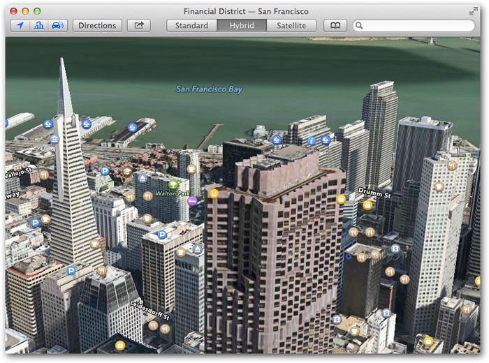
Figure 18-20. Flyover is a dynamic, interactive, photographic 3-D model of certain major cities. It looks something like an aerial video, except that you control the virtual camera. You can pan around these scenes, looking over and around buildings to see what’s behind them. To create this feature, Apple says, it spent two years filming cities from helicopters.