
14.
With the Best of Intentions
Corby in Northampton: This was one of the first round new towns, although more accurately it was an expanded town because it already had a population of 18,000 and was known for its steel industry. The masterplan was prepared by the architect William Holford in 1951, and it remains one of the most successful examples of new town planning and is today the fastest growing town in the UK.
There is a famous photograph taken in 1972 of the Milton Keynes New Town Development Corporation team posing in front of and within the branches of a great oak tree, most of them with long hair and flares.227 Milton Keynes is, after all, a new town built by hippies, with its central axis, Midsummer Boulevard, aligned to sunrise on the Summer Solstice. It was designated in the year that the Beatles released Sgt. Pepper’s Lonely Hearts Club Band, when men first walked on the Moon, and as Concorde took its first flight. As we write, the town is celebrating its 50th anniversary and there has been much discussion and reassessment of its legacy. It is a modern city, rather than a modernist city. Most of its housing is low density and suburban in character and its centre is a civilised grid of boulevards rather than a brutal mega structure. The principles that lie behind the planning of Milton Keynes are the same ones that have guided planning across the UK and further afield in the post-Second World War years: the accommodation of the motorcar; the improvement of housing conditions; the separation of uses; and the benefits of green space. These issues have been central to the planning debate in the latter half of the 20th century, all pursued with the best of intentions if not always the best of results.
The new towns movement in the UK came out of the wartime discussions described in Chapters 12 and 13. The cities of the UK were seen as dysfunctional and overcrowded, and Second World War bombing had provided an opportunity to put this right. The planning system was created and new ideas about planning and architecture were drawn from the modernist movement. An important part of the strategy was a programme of new towns to move population away from the cities, to allow them to be replanned at lower densities. There were eventually to be 20 new towns in England, five in Scotland and two in Wales. The first ten were designated as a result of the 1946 New Towns Act and were mostly in and around the south east of England to handle overspill from London. There were also two, Newton Aycliffe and Easington (later renamed Peterlee), in the north east. East Kilbride and Glenrothes in Scotland and Cwmbran in Wales were designated at around the same time. As David Lock pointed out at one of the events to mark the 50th anniversary of Milton Keynes, these early new towns were generally planned by rather serious ex-military types keen to do the right thing.228 Like Coventry, the towns were influenced by Lewis Mumford and Nikolaus Pevsner’s synthesis of modernism and the Arts and Crafts movement. They are characterised by ring roads and precincts and their architecture often exhibits a rather civilised Scandinavian modernism.
The second wave of new towns was designated in the early 1960s and the towns are very different beasts. They include Skelmersdale and Runcorn, which were planned to relieve the growth of Liverpool (despite the city already starting to show signs of decline), Telford and Redditch around Birmingham, and Washington between Sunderland and Newcastle. A final wave of designations was announced in the late 1960s, including the expanded towns of Peterborough, Northampton, Warrington, Central Lancashire and Milton Keynes. The 1960s also gave us Cumbernauld, Irvine and Livingstone in Scotland and the fortuitously named Newtown in Mid Wales. These later new towns were designated and planned during a period when the architecture and planning communities were in a ferment of ideology and design philosophy, and the new towns were the laboratories where many of these ideas were tested. The Scottish new towns were perhaps the most extreme; in addition to the extraordinary mega structure in Irvine that we mentioned in Chapter 13 (which was never fully realised), the centre of Cumbernauld looked like a version of Archigram’s walking city.
A New Town Built for the Age of the Car
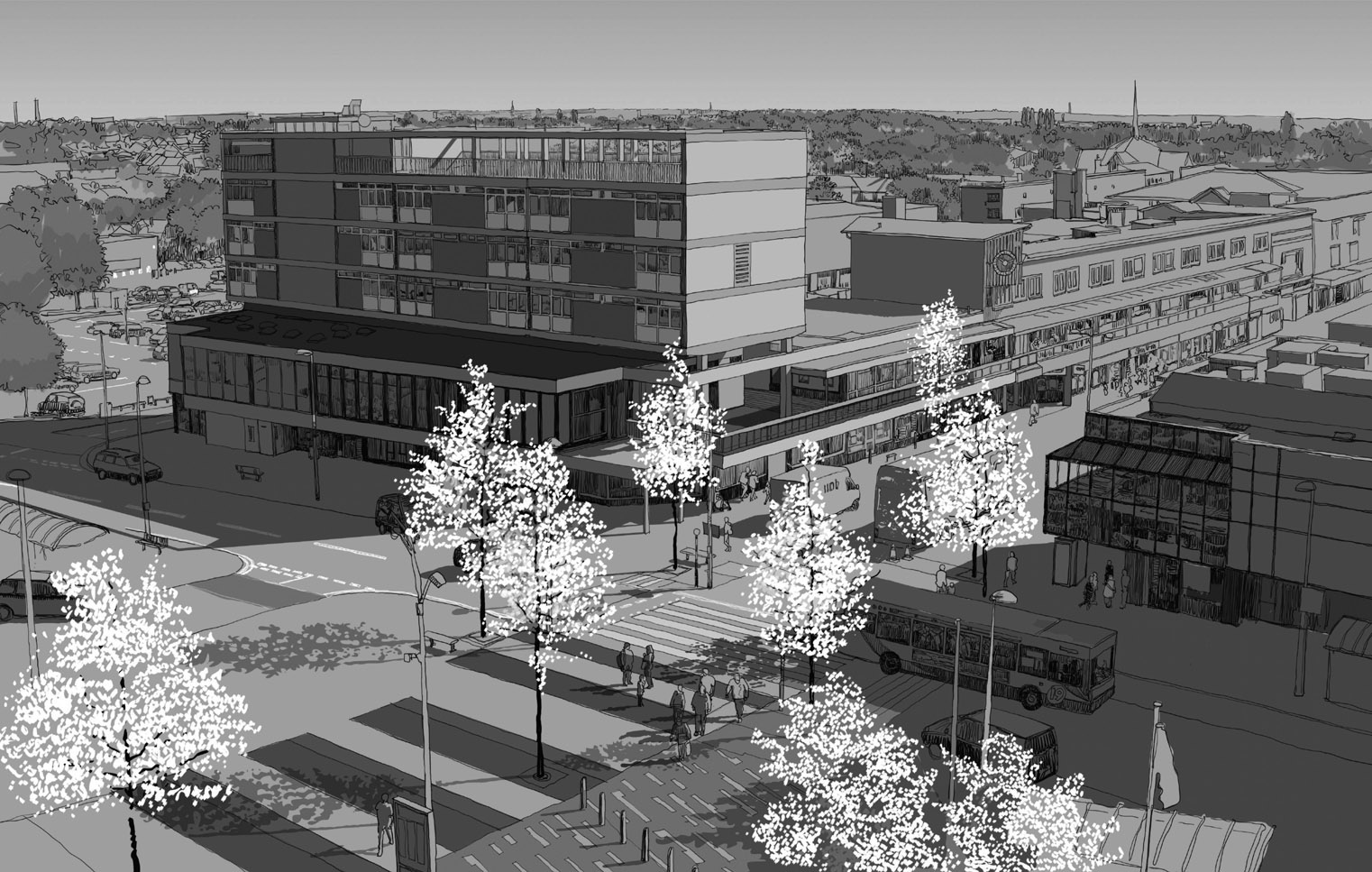
The original plans for Milton Keynes were as extreme as Cumbernauld’s. In the early 1960s, Buckinghamshire county council had started to develop plans for a new town in the sparsely populated north of the county. The county architect, Fred Pooley, was so closely associated with the futuristic proposals that it became known as ‘Pooleyville’.229 The plan was based on a figure-of-eight monorail linking a series of townships and converging on a town centre which would have looked similar to Cumbernauld. It had been intended as one of the Mark 2 new towns, but by the time the plans were published they had missed the boat. There was, however, no denying the advantages of the location, halfway between London and Birmingham (Bletchley had been considered as one of the Mark 1 new towns). In January 1967, the UK government announced the designation of a new town on the land between the existing towns of Brechley, Stony Stafford and Wolverton. With a target population of 250,000, it was to be the largest of the new towns, a new city indeed, to be built on 9,000 ha of rolling Buckinghamshire countryside. Unlike the early new towns that were built almost entirely by the state, 50% of Milton Keynes was to be built by private developers, and in its later years it has become almost entirely private-sector built. As a result, Milton Keynes is not an essay in modernist planning ideologies, as some of the earlier new towns had been (and Pooleyville would have been). It is much more suburban and low-key, and as such could be seen as a microcosm of many of the climax forms that would come to dominate the remainder of the 20th century.
The Milton Keynes Development Corporation appointed the architects Llewelyn-Davies, Weeks, Forestier-Walker and Bor as their masterplanners, working with the US transport engineers Pete Marwick Kates and Co. The academic Michael Edwards, who at the time was working for Nathaniel Litchfield and Associates as a subcontractor to the masterplanning team, has written an account of the design process.230 The masterplan is a departure from the early new towns which, for all of their monorails and ring roads, essentially followed

10km Trellis
Milton Keynes: The plan of the town is based on a loose 1 km grid of roads linked by roundabouts. Each of the grid squares was designed as a neighbourhood, although this had not been the intention of its original designers.
a traditional template of radial routes converging on a town centre. In Milton Keynes, it was argued that the age of the car, with its unlimited personal mobility, required a new urban form, one that didn’t channel all traffic into a single constrained town centre. The masterplan cast a lazy grid of 1-km squares over the site, influenced by the work of the Californian urbanist Melvin M. Webber.231 The logic was the same as that applied in Los Angeles in the 1920s (see Chapter 11), namely that a grid makes all parts of the city equally accessible via personal transport, thereby avoiding the inefficiencies of tidal flows between home and work. The logic of the grid suggested that the town had no need for a centre; shopping and employment could be located anywhere and be equally accessible. This, however, was a step too far for the Development Corporation board (which included Fred Pooley), who saw a town centre as essential to the image of the town and to its ability to attract national retailers.
As Edwards relates, the team spent a long time considering the implications of the grid. What it meant for the arrangements of neighbourhoods, the distribution of shops, schools and other services, public transport routes, the zoning of uses and the structure of open space. This was all given to a team member, the young Francis Tibbalds, to take home for the weekend and synthesise into something coherent. This he did in a series of sketches, diagrams and handwritten notes that were so clear that, rather than have them drawn up and typed, they were Xeroxed as they were for inclusion in the board papers.
The plan was based on two intersecting grids. The road grid was to be laid out as 1-km squares and designed for traffic travelling at 30 mph with traffic lights at the main junctions. A second grid would carry pedestrian movement, cycles and local traffic, and would cross the highway grid halfway between the main junctions. This secondary grid is now known as the ‘red routes’ because of its red tarmac and makes up one of the most extensive cycle networks of any city. In the original plan, the points of intersection between the two grids were going to be the location of local centres with shops, services and schools. It would mean that shops benefited from the passing trade of traffic on the grid roads and that people living in one grid square would have access to up to four local centres. As Edwards suggests, had this plan been built it would have created a very different place, so that: ‘moving through Milton Keynes would … be an experience very similar to moving through a typical European town, built with little formal planning over the last centuries: commerce and services on main roads, housing and employment clustered around the most accessible points and lines, density falling away behind’.232
This was the masterplan that was published in 1970233 and featured in a special edition of the Architect’s Journal.234 It wasn’t, however, the plan that was built, even though the story of how and why this happened remains a source of some controversy. Many of the old planners who participated in the 50th anniversary events (and Milton Keynes is a town with lots of old planners because they all love the place and continue to live there in their retirement) insisted that the grid was always intended to be free-flowing and free of frontage development. They complained that this principle had been ignored in some of the later developments in the 2000s when the planners of Milton Keynes had fallen under

2km Figure Ground
Milton Keynes: The figure ground plan is unforgiving in exposing the lack of structure of the town that is a patchwork of different housing layouts from the modernist layouts to the south (1) to the typical housebuilder layouts elsewhere (2). The city centre (3) is a formal grid of widely spaced boulevards that has a North American character not found in any other UK city.
the spell of urbanists who persuaded them to build frontage development directly onto the grid, contrary to the planning principles of the town. Nevertheless, the archives tell a different story.
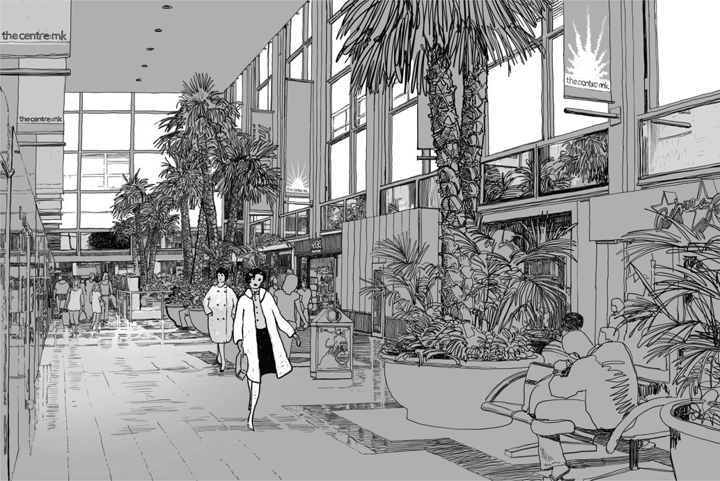
Milton Keynes: The shopping centre in Milton Keynes, one of the first and still one of the best malls to be built in the UK.
The problems started when the highway engineers at the Development Corporation insisted that to achieve the levels of mobility planned for the town the roads should be designed not for 30 mph traffic but for speeds of 60–70 mph. This meant that the traffic light junctions needed to be replaced with roundabouts and the other junctions redesigned to incorporate acceleration and deceleration lanes and preferably to be grade separated. To protect the neighbourhoods from the increased traffic noise, the landscape buffer along the grid roads was greatly increased. This was initially presented as a relatively minor amendment to what was otherwise seen as a strong plan, but it changed everything.
As part of the 50th anniversary celebrations for the town, David Lock Associates republished a report called City Structure produced by the Development Corporation’s Urban Design Unit in 1980.235 This was prepared by the in-house urban designers to review progress on the masterplan, and it reproduces the original plans and assesses the extent to which they have been implemented. It accepts that the main problem was the inability to build the local centres on the grid roads due to the speed of the traffic. Consequently, the neighbourhoods that had been built in the first ten years did not straddle grid roads, as had been planned. Instead, each grid square had been designed as a single neighbourhood surrounded by landscape and hidden from view from the grid roads. The local centres had been located in the centre of these grid squares at the intersection of the red route grid and, because they lacked passing trade, had not been very successful. The City Structure report couches its criticism quite gently given that it was written from within the Development Corporation, but does recommend that the principles of the original plan be reinstated in future development, which they never were. Such had become the influence of the car on the planning of our cities that building a high street with traffic running along it, as had been done in towns and cities throughout history, now seemed like a crazy idea.
How Brookside Beat the Modernists
For all of the influence of the modernists in the professional press and even in the public imagination, most development in most cities in the post-Second World War years was not modernist. We remember the great high-rise and deck-access council estates, but most council housing was built as two-storey family homes, as was the private housing which, as the century progressed, came to dominate housing provision. The suburbs of Milton Keynes, from the early experimental estates to the later suburban neighbourhoods, track this history of residential design in the latter part of the 20th century. The modernists may have won the argument, but no one was interested in debates in academia and the professional press; their concern was to build for respectable council tenants and the growing and increasingly mobile middle classes who would come to shape the climax form of the late 20th century.
The debate about the design of housing came to dominate the shape of cities in the post-war years. The process was one by which new ideas were tried out in the new towns, written up in the professional press and then applied to the development of council housing elsewhere. Some of these ideas were incorporated into policy and started to shape housing in the private sector (which was otherwise pretty disinterested in innovation). It is a fascinating story of innovation in residential design, which has been documented by people like Ian Colquhoun.236 In the UK, much of this innovation was of more interest to architects than it was to residents. This is not the case in the Netherlands, where innovative housing is still being built and is embraced by the public. In the UK, innovative housing has been much less successful or popular and has therefore had only a limited impact. Indeed, over time, British social housing has tended to evolve so that it more resembles private housing, driven in part by a greater willingness to ask tenants what they want. In Liverpool, the council housing built in the 1980s by a radical left-wing council in defiance of the government was suburban in form. This was based on the argument that if the suburban semi on a cul-de-sac was good enough for the middle classes, it was the least that ‘our people’ deserved. In fact, so prevalent did suburban design become in Liverpool that it became known across the country as ‘Brookside’ housing, after a Channel 4 television soap opera based in the city.
In the UK, the election in 1979 of a right-wing government under Margaret Thatcher meant that mass council housing building came to an end and most new housing over the following few decades was ‘Brookside’ housing, built by a small number of volume housebuilders. This created a specific climax state – the cul-de-sac-based suburb (see the public realm plan of Solihull on p. 241) – which is very different to an American suburb or indeed to those in the rest of Europe. It is also very different to the British suburb in the earlier parts of the century. These early suburbs were set out on garden city lines with a loose permeable network of curving avenues and crescents, and occasional cul-de-sacs. They were integrated into their surroundings and incorporated local centres and other facilities along with bus routes and train stations. By the end of the 20th century, the private British suburb had evolved into a confusion of dendritic cul-de-sacs with each housing estate laid out like a tree stemming from a single junction onto the main road (see Bradley Stoke tissue plan on p. 277).
Each estate was built as if it was the last that would ever be built, and the housing was placed facing inwards along the site perimeter, including the main road, which was lined with back garden fences. Thus, when the next site did come forward for development there was no opportunity to create a connection, so that each development became an island unto itself. It is a form of development that struggles to support public transport and it means that walking routes are long and tortuous, so that people become dependent on the private car. Certainly, to live independently each adult member of a household needs to have a car. In research undertaken by URBED (Urbanism Environment and Design), we came across one household with two parents and three grown-up boys, each of whom owned a car and who were visited each weekend by the boys’ girlfriends, each of whom also had a car, so that some weekends there were eight cars parked on pavements and grass verges around this single house.237 The knock-on effects are that local shops and facilities are not viable and people use large supermarkets, roadside pubs and drive-through restaurants. Welcome to the suburbs – a particularly British creation where car dependence is not so much a function of distance, as in the USA, but rather due to the tortuous layout of what is otherwise quite compact suburban development.
It may seem that this modern suburb is the ultimate expression of the market unconstrained by the state. It is certainly true that the British suburb is shaped by our peculiar housing market in which the majority of new homes are built by a handful of huge companies, known as ‘volume housebuilders’. This is very different to most of Europe where the majority of homes (60% in France) are self-built or at least self-developed, or to the USA where suburbs are developed by small real-estate firms. The suburb is also shaped by the residential aspirations of British people, or the minority who would consider buying a new home, but that is a subject for a different book. Our contention is that climax forms emerge when complex systems based on the interaction between people are shaped by a small number of rules, in which respect the modern suburb is no different to other climax forms described in this book. Small changes in the UK planning system and highway regulations have meant that the emergent pattern of its suburbs is very different to those elsewhere in the world. Tweak the system, change a few policies and the likelihood is that the pattern will stay the same. However, at some point, a small alteration could cause the emergent form to change completely. This is what has happened to the UK suburb: it has transitioned into a climax state that no one designed or intended.
The middle classes of France, Britain and the USA are not that different and yet they live in very different suburbs. These differences are regulatory rather than social. If you spend time studying diverse places, you often find seemingly innocuous policies that have a significant effect on the form of development. In parts of India, you are not allowed to build within a metre of the edge of your site because of fire regulations, whereas elsewhere party wall regulations mean that all buildings must be joined. Commonly in England, a ‘privacy distance’ is applied, which can mean that facing windows need to be 20 m apart, whereas no such prudishness apples in the USA and suburban homes fill far more of the site and are closer together. Any policy that requires more than one parking space per house mandates detached and semi-detached housing and significantly reduces densities. Each of these policies changes the form of development, often in ways that were not envisaged by policymakers. It is a huge subject – we could devote many pages to exploring how the plot ratio system in France has shaped its suburbs differently to those in the UK, and we could look at the Scandinavian, American, Australian, even Indian, suburbs and track the way that small changes in policy have a profound effect on form. However, there is a thread that we can follow through this maze and it is one that trails behind a car. The modern suburb across the world is shaped more than anything else by the private car or, more accurately, by the attempt of authorities to control its use and to stop it killing people.
The Car-based Suburb
Traffic has affected the climax state of cities since cities were first built. The size and geographical extent of a city is directly related to the distance that people can move on foot, by horse or by various forms of private and public transport. As we saw in Chapter 11, the invention of trams and trains allowed cities to extend outwards and the arrival of the private car allowed them to sprawl. The corollary of this is that the problem of congestion and safety is as old as cities. The Romans, no doubt, complained bitterly about chariot congestion, and Victorian London was a chaotic melee of horses and carriages, and was forever struggling to deal with the resulting mountains of dung. In both cases, highways regulations were no doubt introduced and building codes amended to address the problem. However, these didn’t really start to affect the city until the arrival of the private car.
We forget how recently the car arrived in our cities – there were virtually no cars at the beginning of the 20th century. The boom in car ownership started in the USA in the 1920s with the arrival of affordable motoring in the form of the Model T Ford. By 1930, car ownership in the USA was approaching 50% and Americans drove around 200 billion miles a year (compared to 3,000 billion miles today). In the UK, the trend happened much later. The Austin 7 was the UK equivalent of the Model T, being produced in the 1920s and 1930s, but it did not lead to the same level of mass car ownership. Indeed, by 1960 there were only 5 million private cars in the UK (compared to 27.3 million today). Much of the interwar housing that shaped the British suburb was built at a time when few suburban households owned a car. Whereas US suburban real-estate adverts emphasised the double garage and the trophy car sat on the drive, illustrations of British private suburban housing didn’t even have driveways. There were streets of course, the domain of the delivery man and the children playing football, but very few cars.
In 1960, Colin Buchanan was commissioned by the UK Ministry of Transport to look at the UK’s growing traffic problems. His report, Traffic in Towns, published in November 1963 and republished by Penguin Books the following year, predicted that car ownership would quadruple by 2010, by which time there would be 40 million vehicles on the UK’s roads (he wasn’t that far off; the figure including commercial vehicles was 34.4 million in 2012). Buchanan concluded that:
Buchanan has been blamed as the father of all of the intrusive road schemes that were built in the following years – the flyovers and underpasses, dual carriageways and grade-separated junctions that scarred all British towns and cities – but his report is very much focused on solving a problem that at the time was seen as inevitable. Looking at the American experience, he concluded that most British adults would come to take the car ‘as much for granted as an overcoat’ and yet Britain didn’t have the space to indulge these levels of car use and was in danger of grinding to a gridlocked halt. At one point, the report states that ‘distasteful though we find the whole idea … some deliberate limitation of the volume of motor traffic is quite unavoidable’. In a sense, the traffic schemes illustrated in the report were a warning of what would have to be done to British cities if this problem wasn’t addressed; however, in the excitement of post-Second World War rebuilding, they weren’t seen that way. Instead, they were viewed as a vision of a modern future of unlimited personal mobility, a clean civilised alternative to the dirty congested streets of many of the cities of the time. The response of the UK government in the 1960s was the equivalent of the streetcar decision in Los Angeles in 1926. The Beeching Report, also published in 1963, led to the decommissioning of 8,000 km of railway line and the closure of more than half of all stations.239 At the same time, cities across the country were ripping up outdated tram networks to make more room for the car. Far from taking ‘distasteful’ decisions to limit car use, Britain was turning itself into a car-dependent country and would pay a heavy price in the years to come.
This sets the context for the evolution of housing design in the latter half of the 20th century. The decision, however unintended, to downgrade public transport in favour of the car would have a profound effect on the form of residential development, although the main concern was not so much congestion as the problem of safety. The early days of motoring, before the integration of safety features on cars (and highway innovations such as traffic lights and pedestrian crossings), were a time of carnage. The annual number of people killed on the road in the USA in the 1920s was about the same as it is today despite the number of miles travelled being only 6% of today’s number. At the time, an average of one child a day was killed by a car in New York, and it is therefore unsurprising that there was a widespread clamour for something to be done. This led to a number of innovations in planning policy, which were generally born in the USA and then exported to the rest of the world. Two were to be particularly influential in shaping the climax state of British housing: Radburn layouts; and the neighbourhood unit that we will return to on page 278.
Separating Cars from Pedestrians
In 1929, the architect Clarence Stein was commissioned to design a suburb in New Jersey. Influenced by the British garden city movement but aware of the fact that most of the residents would own a car, and being concerned about the shocking accident levels elsewhere, he set out to build a ‘garden city for the motor age’. The scheme was called Radburn and it gave its name to a form of housing that would be incredibly influential on British planners.
The housing layout at Radburn was the first to create a pedestrian circulation system that allowed people to walk to the local centre, the park and the school without the need to cross a road. It does this by the simple expedient of super-blocks measuring 300 m by 600 m. These blocks are bounded by roads, from which a series of cul-de-sacs extend into the centre of each block. These cul-de-sacs provide car access to the front of each home while a separate pedestrian network links to the back gardens, via which residents can walk through a central area of open space to local facilities. This layout completely turned thinking on housing layout on its head. Not only was it the first to separate cars and pedestrians but, as a consequence, it invented the road layout based on distributor roads and cul-de-sacs. The first cul-de-sac has been credited to Louis de Soissons in his plan for Welwyn Garden City, but this was simply a way of opening up the centre of larger blocks, otherwise all the houses fronted onto a network of streets. In Radburn, the entire layout was predicated on cul-de-sacs, presenting an alternative to the permeable street network (either formal grid or informal garden city layout) that had structured all development up until that point.
As so often with this type of innovation, the Radburn concept didn’t really come into its own until it infected the planning profession in the UK. Britain was the place where theories were built rather than just debated. Radburn became one of the schemes taught to every British planner as part of their training. So, when in the 1960s Britain experienced its own motor age, it seemed to be a good place to turn for inspiration. The huge growth in British car ownership in the 1960s made the case for the separation of cars and pedestrians seem obvious. In town centres and on high-rise estates this was done via Buchanan-inspired subways and elevated walkways, but with low-rise housing it was Radburn that provided the answer.
Radburn estates were built throughout the UK from the early 1960s through to the early 1980s. As a planning student in 1980, I (DR) was taught that it was the ‘correct’ way to do housing layout. Something, however, was lost in translation, quite a lot in fact. As with many good ideas, a layout developed for the middle classes in New Jersey didn’t work quite as well for a council estate on the outskirts of Hull. Private housebuilders in the UK, on the whole, did not adopt Radburn layouts and traffic regulations did not make them mandatory. British Radburn estates were largely confined to social housing and looked very different to the leafy streets of the original. They were built at much higher densities and included one particular refinement that guaranteed they would never work. Whereas the houses in the original Radburn faced onto the street, British planners decided to turn them around so that they fronted onto the pedestrian network, with cars relegated to rear parking courts. Anyone who has spent any time on a Radburn estate in the UK will know what a disaster this was. Residents no longer understood which was the private side of their home; indeed, everything became public. Cars parked beyond high ‘rear’ garden fences were vulnerable to crime, while the pedestrian walkways at the ‘front’ were deserted and dangerous. Overall, the layouts became convoluted and confused, making them impossible to police and

80m Tissue Plan
Orchard Park, Hull: This estate on the edge of Hull shows the way that Radburn was interpreted in the UK. Each group of houses is accessed by road from one side and via footpaths from the other. However it makes for a convoluted layout and for a confusion about which is public and private realm.
Radburn, New Jersey: Clarence Stein’s original plan for Radburn showing houses fronting onto cul-de-sacs with a footpath from their back garden linking to a network of open space. The footpaths through this open space pass beneath bridges under the road system so that people can move around without ever having to cross a road.
turning them into no-go areas for anyone who didn’t live there.
The Cul-de-sac
Radburn layouts were no good at all for Britain’s private housebuilders. For one thing, they were interested in ‘kerb appeal’ and so needed the houses to face onto a street, preferably with a driveway and garage where the family car could be displayed and washed at the weekend. Developers of private estates were, however, equally keen to avoid through traffic and to build quiet, safe environments so, while rejecting Radburn, they were happy to adopt the cul-de-sac. In 1977, the UK Department of Transport issued guidance for the design of Residential Roads and Footpaths in the innocuously named Design Bulletin 32.240 The guidance stopped short of making Radburn layouts mandatory but used the principles to establish a set of rules for the layout of residential development. More than any other document, DB32, as it is known, has shaped the British suburb during a period when suburbs came to dominate housing production. We could say that it has shaped the climax state of the British city. Even today, after many attempts to overturn or even revise DB32, it is still used by highways engineers and continues to exert a pernicious influence on the quality of development. This is largely because of the legal basis of highway engineering in the UK, which means that if a highway engineer departs from the guidance and there is an accident, they or their employer can be legally liable.
The principles in DB32 are derived in part from accident statistics showing that half of all road accidents in built-up areas occur on main routes, with a further quarter taking place on ‘distributor roads’, and only 10% on minor streets with no through traffic. It further shows that half of all road accidents to children below the age of five take place within 100 m of the home. The inevitable conclusion is that all houses should be built on minor streets with no through traffic. The guidance therefore establishes a hierarchy of streets with primary, district and local distributor roads and residential access roads. The aim is to keep the distributor roads free of frontage development as far as possible to aid the flow of traffic and reduce accidents. Housing would then be located on residential roads providing access to no more than 300 homes and providing no through routes. The result is the British suburb, with sweeping distributor roads lined with grass strips and the back garden fences of homes, with occasional junctions giving access to closed systems of cul-de-sacs serving up to 300 homes. In urban locations, the rules meant that a housing site would have to be accessed from the least important of the surrounding streets, causing the new homes to present their back garden fences to the most important street, even in cases where that street was a high street lined with shops.
In the late 1990s, Alan Baxter Associates were commissioned by the UK government to rewrite DB32. It was recognised that the guidance was having a damaging effect on the quality of new residential development in the UK, particularly in the light of ‘new urbanist’ schemes like Poundbury in Dorset, which had been promoted by Prince Charles and on which Baxter had been the highway engineer. The resulting report was called Places, Streets and Movement but unfortunately the subtitle was A Companion Guide to Design Bulletin 32.241 It had been decided that the liability issues were just too great and that rather than rewrite the original guidance, the new report should show how it could be interpreted
80m Tissue Plan
Bristol, Bradley Stoke: This is a typical piece of DB32-inspired housing. The distributor road can just be seen in the top right corner (1) with housing backing onto it, while most housing is located on cul-de-sacs without through traffic.
more flexibly to allow good urban design. It was a messy compromise and DB32 retained its influence until the 2007 publication of Manual for Streets.242 This was written by the highway engineering firm WSP, together with the Transport Research Laboratory and Llewelyn Davies Yeang (the masterplanners of Milton Keynes). This new guidance replaced DB32 and mandated a much more urban approach to highway engineering. Nonetheless, even as we write in 2018, research by the Urban Design Group seems to suggest that many highway authorities are still implementing local policy derived from BD32, which they see as more relevant to their area than the more urban Manual for Streets.243
This is the story of the influence of highway engineering on the UK but similar stories could be told in every country. In each case, rules have been written to deal with the growth in car ownership and those rules have created a particular form of development. Change the number of homes that can be served off a single access from 300 to 100 and a completely different form will emerge; permit homes to front onto main roads or enable through access or, at the other extreme, allow access points to be gated and the pattern will reset once more. These forms affect not only the environment around the home but the shape of the entire settlement. They determine whether local shops are viable or whether everyone has to use supermarkets, they affect modal transport split, the attraction of walking and cycling, and the viability of public transport. This also affects crime levels and accident rates. One of the ironies of the residential cul-de-sac is that it protects its residents within its immediate environment but, as Mayer Hillman et al. have shown, can make the wider environment more dangerous, with children being less able to deal with main streets when they come across them.244
The Neighbourhood Unit
This brings us back to Milton Keynes and the story of the neighbourhood unit. It was appropriate that the highway engineers were the ones to insist that each neighbourhood within Milton Keynes should sit within a grid square rather than straddling one of the grid roads. It was concerns about traffic, after all, that had led to the development of the neighbourhood unit as a planning tool. Back in the New York of the 1920s, a city planner called Clarence Perry recognised that one of the traditional functions of the street was to accommodate children’s play. This had been safe enough before the invention of the car but was now the cause of the city’s terrible level of child road fatalities. He therefore suggested that the city authority should invest in playgrounds and developed a formula to work out how many playgrounds would be required. Perry started to refer to the area served by a single playground as a neighbourhood. He went on to design a spatial framework for these neighbourhoods, each of which would be bounded by main traffic routes but with no through traffic, allowing the playground to be built in the traffic-free heart of the resulting super-block.
Perry soon realised he was onto something and developed the notion of the ‘neighbourhood unit’. The idea was set out in Perry’s 1929 monograph ‘The Neighbourhood Unit: A Scheme for the Arrangement of Family Life and Community’.245 In this, he proposed an ideal neighbourhood unit based on a particular population with a measured out set of community facilities, such as a primary school and community centre alongside the central playground. The whole was designed as an inward facing unit, freed from through traffic and surrounded by main roads. However, because Perry was initially trying to deal with the existing city, he continued to envisage that commercial development and shops would be located on the main roads and therefore on the edge of the neighbourhood – thus causing confusion about the location of the neighbourhood centre. Mumford lauded Perry for taking the organic idea of neighbourhoods that develop naturally in cities and turning it into a codified planning tool to create the ‘modern equivalent of a medieval quarter or parish’.246
If this was as far as Perry’s ideas had been taken then it would have remained a sensible reform, dealing with the problems of traffic without undermining the structure of urban areas. But this is not how planning works. The urban professions are prone to pounce on an idea like the neighbourhood unit and stretch it to the point where it no longer makes sense. It is done with the best of intentions – who, after all, could argue with the aim of protecting children? – but ends up damaging the fabric of urban areas. Like Radburn, Perry’s neighbourhood unit was picked up and taught in planning schools as a particularly useful building block to structure the design of new housing areas, rather than simply restructuring existing ones. In the process, the confusion about where the centre of the neighbourhood should be was resolved. Pedestrianised shopping precincts were built in the middle of each neighbourhood, enabling peripheral streets to be kept free of development so that traffic could run freely through landscaped corridors (parkways), meeting majestically at grade-separated roundabouts. Thus, the city was turned inside out, allowing cars to be separated from people and creating play facilities, schools, and retailing in just the right quantities for the allowed population of the neighbourhood units.
By the time Tibbalds presented his elegant hand-drawn diagrams of Milton Keynes’ grid, the neighbourhood unit had already been planning orthodoxy for 30 years. To the highway engineers and planners in the Milton Keynes Development Corporation, Tibbalds’ idea went against what they had been taught and brought with it the risk that there would be accidents and that they would be blamed. The urban designers may have won the argument at the time, and the agreed masterplan endorsed their solution, as did the Development Corporation’s Urban Design Unit ten years later, but it wasn’t what was built. This is the history of planning: sensible policies developed with the best of intentions but taken too far and eventually applied unthinkingly in the face of evidence that they are doing harm. The process is fuelled by academia where ideas are ‘refined’ and then taught to each generation of students. It is aided by the way that urban professions are divided into silos, each concerned with optimising their area of concern but with no overview of the effect on the whole system. The most powerful of these silos, since the invention of the motorcar, has been highway engineering, whose arguments that they are saving children’s lives will always trump any concerns for creating good places.
***
In the latter half of the 20th century, the UK used the newly minted planning system with the best of intentions to make the worst of all worlds. There are very few people who would suggest that the new places built since the introduction of the modern planning system are better than those that came before. They may be more efficient and may even have fewer accidents (although this is often not the case), but they lack the attributes of character and sense of place that is valued in traditional places. We have focused in this chapter on the impact of the car on residential design in the UK. A similar story could be told of retail development and the invention of out-of-town shopping, or of the leisure industry and the invention of the drive-through restaurant, or of office and industrial parks. We could then have visited different countries and recounted their particular versions of this story, each of which has a similar unhappy ending.
We have argued in this book that human societies have an inherent ability to build neighbourhoods that work pretty well. They may initially be built with cast-off timber and corrugated sheets but, given time, they will evolve into the traditional urban forms that we value across the world. This is not to romanticise these spontaneous environments that involve terrible living conditions. Our impulse to reform these places is entirely understandable and the invention of planning was done with good intentions. Yet in doing so, we have disrupted the process by which the climax city evolves. Some may argue that we have destroyed the process entirely and that we should be free to plan urban areas on paper and implement them without the need for evolution. However, the process of incremental urban growth didn’t stop with the invention of planning. What the planning system did was to alter the conditions of the system and, as complexity theory shows, it sometimes takes only a small change to alter the entire emergent pattern.
The planning policies of the late 20th century did just this; they may have only intended to deal with the car, but they ended up causing entirely new urban patterns to emerge, one of which was the British suburb. No one proposed the suburb as an ideal urban form, it looks nothing like the early garden cities, Radburn or even the early estates of Milton Keynes. It is the unthinking result of rules that generated an optimised urban form that no one really foresaw or wanted. If we better understood this process we could perhaps use it to our advantage. Rather than blunder around trying to solve one problem and in doing so creating several more, we might use planning to shape complex urban systems to produce places that work and that are also attractive. We will make mistakes because, by definition, complex systems are beyond our control, but the starting point must be to embrace this complexity and to work with it rather than against it.