
Experience More

t Colorful market stalls of local farmers and producers in San Isidro de El General
The peaceful market town of San Isidro de El General sits at the base of Cerro de la Muerte. For tourists, it serves mainly as a refueling stop and base for exploring the Chirripó and La Amistad national parks. The only sight of interest in town is the modern, concrete cathedral on the east side of the plaza, with stained-glass windows and a simple altar dominated by a mural of San Isidro Labrador, patron saint of San Isidro.
At Quizarrá, 9 miles (14 km) southeast of San Isidro, there’s a treat for bird-lovers: Los Cusingos Neotropical Bird Sanctuary. Administered by the Tropical Science Center of Costa Rica, this 1-sq-mile (3-sq-km) refuge for birds was founded by eminent American ornithologist Dr. Alexander Skutch (1904–2004), co-author of the authoritative Birds of Costa Rica. More than 300 bird species have been noted in the sanctuary, and Skutch’s former home has been kept and maintained as if he still lived there.
Cerro de la Muerte acquired its name – “Mountain of Death” –in remembrance of the people who died of exposure while on the road to San José with their produce before the Pan-Am Highway was built across it. The road passes along boggy grassland below the wind-buffeted summit (11,500 ft/ 3,500 m). When the clouds part, there are superlative views.

GREAT VIEW
Eyes Down
When driving over Cerro de la Muerte, stop at Km 119, where the view down over Valle de El General from Mirador Vista del Valle is stunning. Linger over a meal at the veranda restaurant here to savor the vista below.
Extending into Panama, the International Friendship Park is contiguous with other protected areas that form the sprawling Reserva de la Biosfera La Amistad (Amistad Biosphere Reserve). It spans over 675 sq miles (1,750 sq km) of the rugged Talamanca Mountains, and ranges from elevations of 490 ft (150 m) to 11,650 ft (3,550 m) atop Cerro Kamuk. The diverse wildlife in this enormous park includes five cat species and the bare-necked umbrellabird. With permits and a guide, experienced hikers can cross the Talamancas on a trail that starts from the town of Buenos Aires, 38 miles (61 km) southeast of San Isidro, and leads to the Reserva Indígena Talamanca-Cabécar.
The main ranger station, a hostel, and an ecology exhibition are at Estación Altamira, the recommended entry point north of Guácimo. All the official access points require 4WD.
At Finca Coffea Diversa, below Estación Altamira, visitors can wander among rows of flowering shrubs and more than 200 coffee bush species. The rural communities of Carmén, Altamira and Biolley are enlivened with ceramic murals.

t Cute and colorful, a resplendent quetzal at La Amistad park
"
Finca Coffea Diversa
⌂ Altamira, 1 mile (1.6 km) W of Estación Altamira # 8am–5pm daily ∑ coffeadiversa.net
Did You Know?
La Amistad spans eight “life zones,” from low montane rainforest to swampy high-altitude grassland.
One of the world’s leading tropical research and educational centers, Las Cruces is run by the Organization of Tropical Studies (OTS). The center is surrounded by a 1-sq-mile (3-sq-km) mid-elevation forest, in which an incredible diversity of birds and mammals can be seen along 15 miles (25 km) of trails. Clouds envelop the reserve, nourishing the many ferns, palms, bromeliads, and orchids laid out in the Wilson Botanical Gardens, designed by distinguished Brazilian landscaper Roberto Burle-Marx. A riot of color in even the rainiest of weather, the collection extends to glasshouses, where tropical plants are propagated.
A sportfishing base, port, and administrative center for the southern region, dilapidated Golfito (Small Gulf) unfurls along 4 miles (6 km) of shoreline. Established by the United Fruit Company in 1938, the town’s reign as the nation’s main banana-shipping port ended when the company pulled out in 1985. The legacy of “Big Fruit” can be seen in the intriguing architecture of Zona Americana, at the north end of town, which has stilt-legged wooden houses. The small plaza in Pueblo Civíl, the town center, abuts a busy water-taxi wharf. The Museo Marino nearby is worth a peek for its corals and seashells.
On weekends and holidays, Golfito is flooded with Ticos drawn to the Depósito Libre (Free Trade Zone) shopping compound created in 1990 to revive the town’s fortunes.
The forested hills east and north of town are protected within the Refugio Nacional de Vida Silvestre Golfito.
Museo Marino
⌂ Hotel Centro Turístico Samoa, just N of Pueblo Civíl § 2775-0233 # 7am–10pm daily
EXPERIENCE Southern Zone
|
Eat Trapiche de Nayo Wonderfully rustic mountainside Tico restaurant where oxen still work an age-old trapiche (sugar press). ⌂ Cerro de la Muerte § 2771-7267 \ Phat Noodle Great Thai food and cocktails served from a funky converted school bus to diners at canopied tables. ⌂ Dominical ∑ phatnoodlecostarica.com \ Citrus Stylish restaurant with a sophisticated menu of fusion dishes. ⌂ Ojochal § 2786-5175 \ |
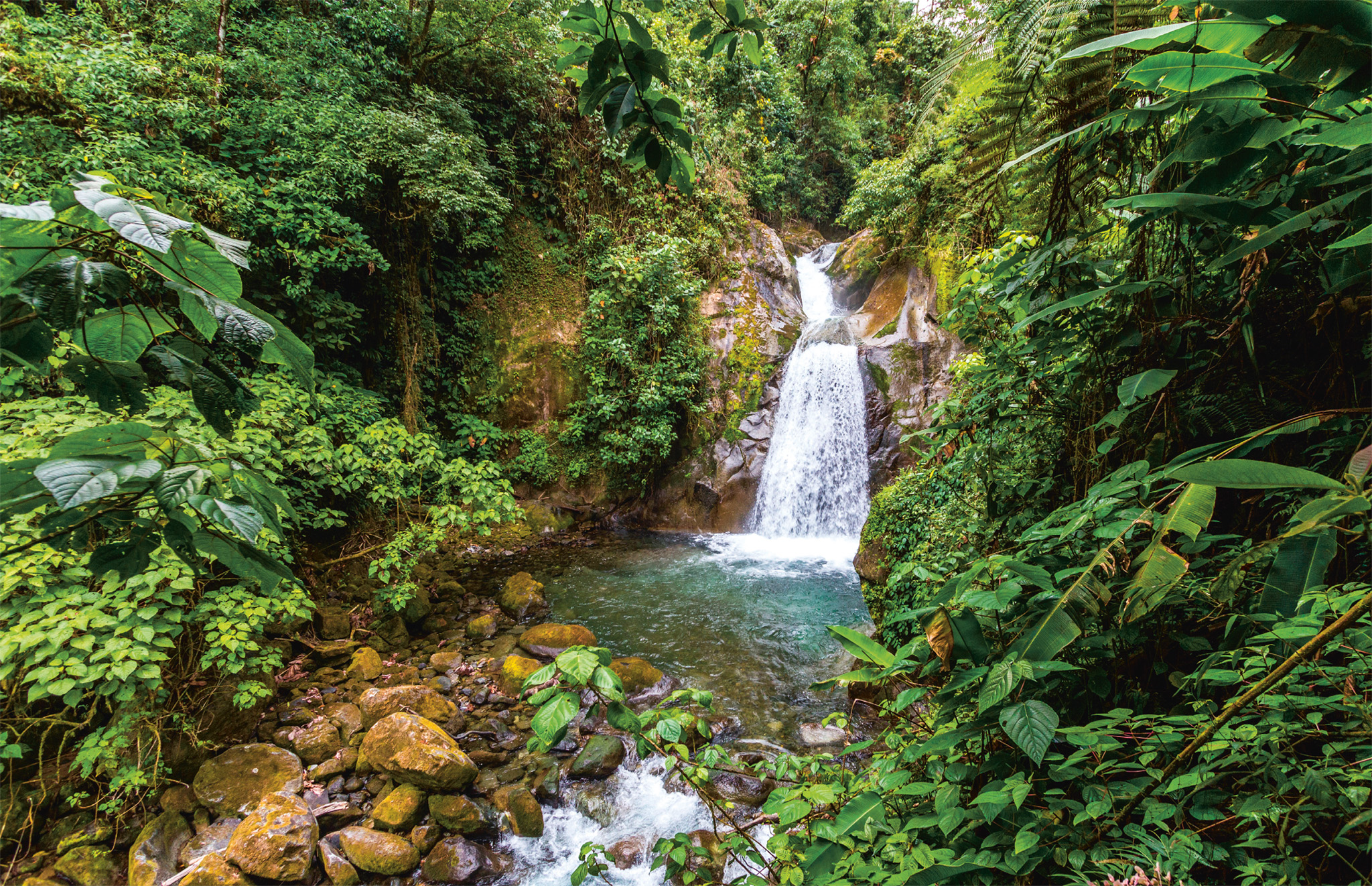
t Water cascading from the mountains down the Valle del Río Chirripó
This valley is scythed from the Talamanca Mountains by the turbulent Río Chirripó. Trout swim in the river’s waters, where rapids provide kayaking thrills. A great place to stop in the valley is the fruit-and-coffee finca Rancho La Botija, a popular destination for locals on weekends. Its attractions include an antique sugarcane mill, a restaurant, and cosy rooms. Nearby, the roadside Piedra de los Indios (Rock of the Indians) bears pre-Columbian petroglyphs as well as some modern graffiti.
The scenery grows more dramatic as the road climbs into the mountains to reach San Gerardo de Rivas. Perching over the river gorge, this hamlet is the gateway to the Parque Nacional Chirripó. Close by, the Museo el Pelicano is a curiosity for its inspired stone and timber art by coffee farmer Rafael Elizondo Basulta. Aguas Termales, nearby, has natural thermal pools popular with local families seeking to counter the chilly mountain air. A steep track leads past the trailhead to the summit of Cerro Chirripó and ends at the Chirripó Cloudbridge Reserve; there are also some good hiking trails.
Museo el Pelicano
⌂ Canaan, 10 miles (16 km) E of San Isidro § 2742-5050 # 7–11am daily
"
Aguas Termales
⌂ 1 mile (1.6 km) NW of San Gerardo § 2742-5210 # 7am–5pm daily
" '
Chirripó Cloudbridge Reserve
⌂ San Gerardo de Rivas, 12 miles (20 km) E of San Isidro # 6:30am–6:30pm daily ∑ cloudbridge.org
EXPERIENCE Southern Zone
Pre-Columbian Petroglyphs
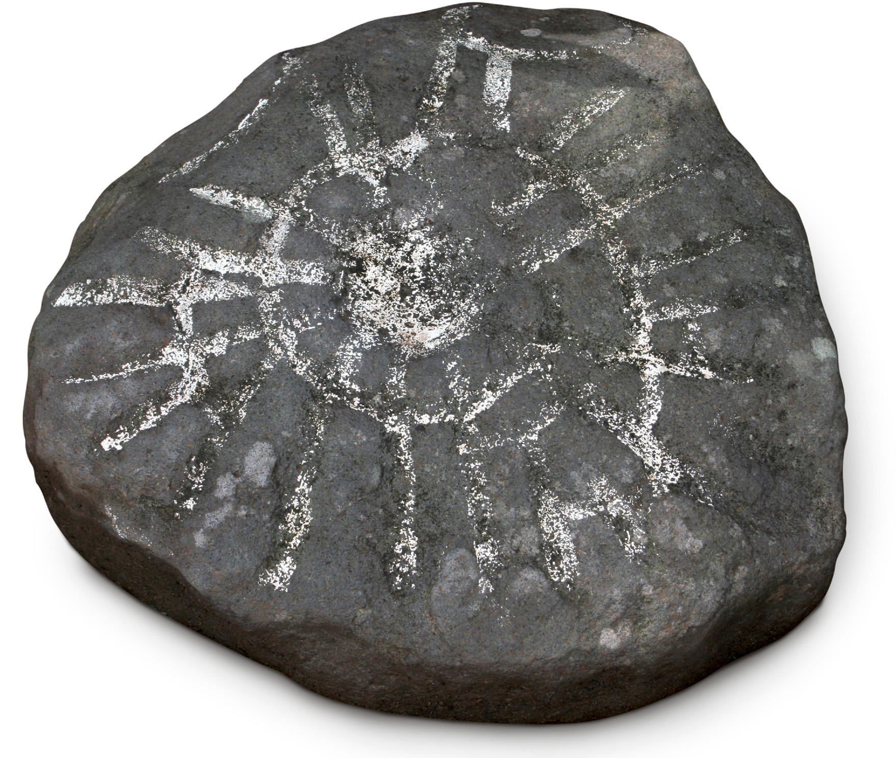
Costa Rica’s pre-Columbian peoples left their legacy etched on boulders. Significant finds include Guayabo National Monument, where jaguars, snakes, frogs, and birds of prey symbolize creation, wealth, and power. Piedra de Los Indios and Rancho La Bojita, both in Valle del Río Chirripó, have interesting petroglyphs, including a crude map of the Talamanca region.
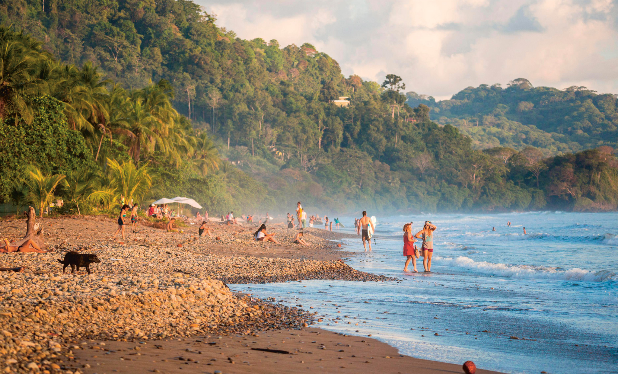
t Domenical beach, popular with families, budget travelers, and surfers
A surfers’ paradise, this village thrives on the backpacker trade: the community is a mix of locals and foreign surfers who have settled here. Its long beach extends south to the fishing hamlet of Dominicalito. In town, Costa Rica Surf Camp offers a great introduction to the waves. Non-surfers should beware of riptides. South of Dominical, lie thickly forested mountains, the Fila Costanera, also called Escaleras (Staircase). Tour companies in Dominical offer hikes, plus all-terrain-vehicle and horseback trips up its slopes.
Highway 243 winds through the Río Barú valley, connecting Dominical to San Isidro. Tour companies offer trips to Don Lulo’s Nauyaca Waterfalls, a dramatic, two-tiered waterfall a 4-mile (6-km) horseback or jeep ride from the highway. Nearby, Parque Reptilandia exhibits dozens of reptile species, including a komodo dragon. Guided tours offer an insight into reptilian behavior.
Costa Rica Surf Camp
# 8am–8pm daily ∑ crsurfschool.com
"
Don Lulo’s Nauyaca Waterfalls
⌂ Platanillo, 6 miles (10 km) E of Dominical ∑ cataratasnauyaca.com
" '
Parque Reptilandia
⌂ Platanillo # 9am–4:30pm daily ∑ crreptiles.com
Created to protect the nation’s largest coral reef, Whale Marine National Park stretches for 8 miles (13 km) along the shore of Bahía de Coronado, and extends 9 miles (14 km) out to sea. It is named after the humpback whales that gather in the warm waters at a peculiar whale-tail-shaped point to breed between December and April. Several tour operators offer whale-watching trips. Regulations on operators and the number of whale-spotting boats that can be in the bay at any given time are very strict. The Costa Rican government has over 60 policy points that each licensed tour operator must fulfill before they are allowed to take to the seas.
The park incorporates Las Tres Hermanas and Isla Ballena, which are important nesting sites for frigate birds, brown boobies, and pelicans. Kayaking and scuba diving trips can be arranged.
Refugio Nacional de Vida Silvestre Rancho Merced, to the north, offers city-slickers a chance to play cowhand; it also functions as a wildlife refuge. To the south, sustainably operated La Cusinga Lodge offers great wildlife-spotting opportuties on its trails in the hilltops above pristine beaches. Nearby, the twin hamlets of Tortuga Abajo and Ojochal make a good base for exploring the area; Ojochal has some great restaurants.
'
Refugio Nacional de Vida Silvestre Rancho Merced
⌂ Uvita, 11 miles (18 km) S of Dominical ∑ rancholamerced.com
EXPERIENCE Southern Zone

Whales off Costa Rica
Humpback
These whales will leap out of the water in “super groups” of up to 200.
False Killer
Actually a dolphin, these highly social mammals form pods with as many as 500 members.
Bryde’s
Known for their taste for anchovies, these whales snap up shoals at a time.
Pilot
Scientists can’t explain why these whales so often beach themselves.
EXPERIENCE Southern Zone
Tropical Flowers
A hothouse of bio-diversity, Costa Rica has over 15,000 known plant species. Each one has evolved to thrive in its ecosystem.
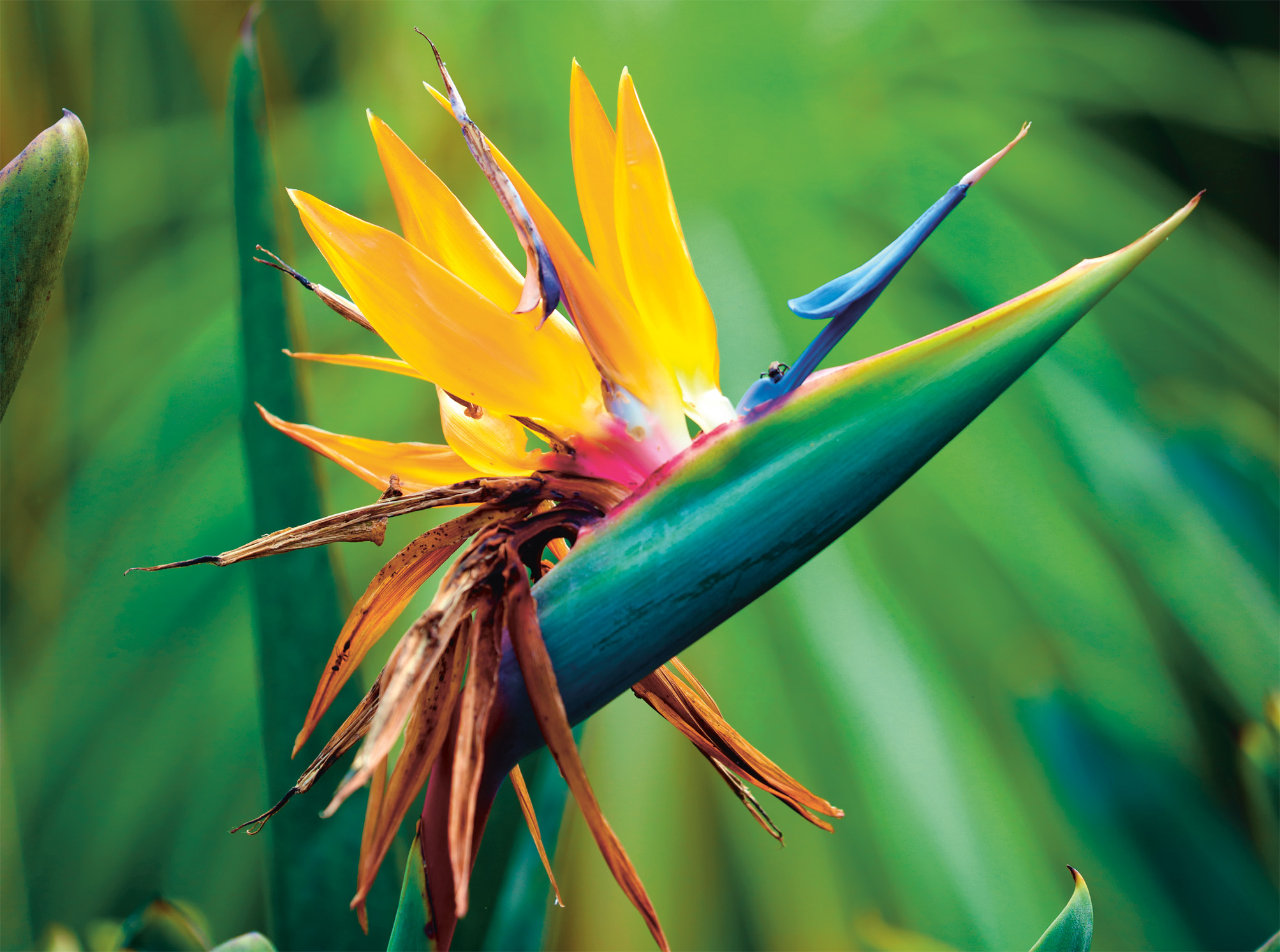
t The pollen-covered blue “perch” from where birds reach the strelitzia’s nectar
For the birds
Bird-pollinating plants often have elongated flowers that mimic the shape of a bird’s beak. The long orangish-red tubular flowers of the firebush are perfect for the curved beak of the hummingbird. Also known as the hummingbird bush, the flowers’ sweet-tasting nectar is an additional draw.
Open all Hours
Flowers that open at night or in the darkness of predawn, such as those of the endemic Costa Rican sage, ensure that they receive more visits by pollinators, even when their scent starts to fade.
Foul Odours
Several flowers emanate a foul smell to attract pollinators. The “Dutchman’s pipe”, for example, smells like rotting flesh, to attract flies.
EXPERIENCE Southern Zone
Orchids
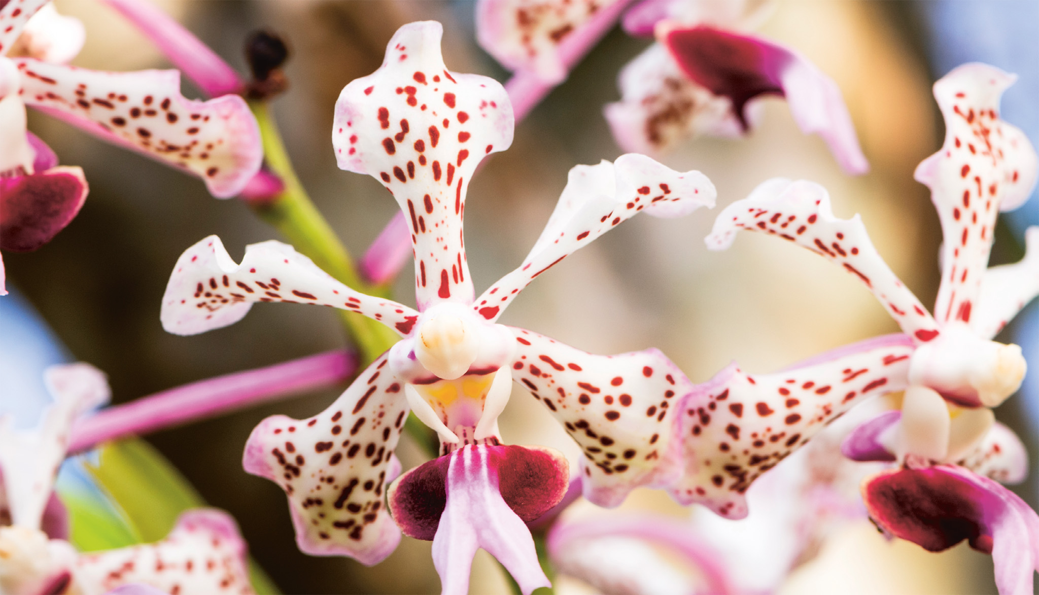

t HELICONIA
Over 1,400 species of orchids grow in Costa Rica. The greatest numbers are found below 6,000 ft (1,830 m). All orchids have three petals and three sepals. Some have evolved features to attract specific pollinators such as markings visible only to insects that can see the ultraviolet spectrum.
A former cattle ranch and cocoa plantation, the 1-sq-mile (3-sq-km) Hacienda Barú has varied habitats, including 2 miles (3 km) of beach that draw nesting turtles. Here turtle eggs are collected and incubated in a nursery for release. Barú also has more than 310 bird species, and mammals such as the arboreal kinkajou. There are butterfly and orchid gardens, and opportunities for guided tree-climbing, kayak trips through the mangroves, and overnight stays in treetop tents.
This is just one of several indigenous reserves inhabited by the Boruca and Bribri in the mountains that hem the Valle de El General. It is especially known for its Fiesta de los Diablitos, as well as its carved jícaras (gourds) and balsa-wood máscaras (masks). The women use traditional backstrap looms to weave sturdy cotton purses and blanket-like shawls. Local culture is showcased in the Museo Comunitario Boruca.
Flanking the Boruca reserve, the Reserva Indígena Cabagra, home to the Bribri, can be accessed from the town of Brujo, 7 miles (11 km) southeast of Buenos Aires.
=
Museo Comunitario Boruca
⌂ Boruca, 25 miles (40 km) SW of Buenos Aires § 2730-5178 # 9am–4pm daily
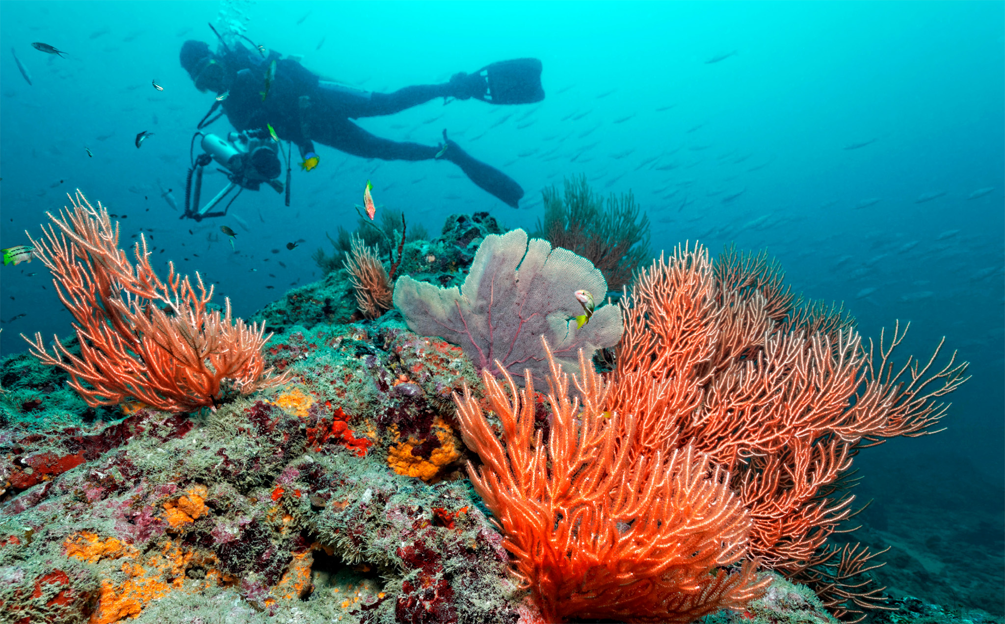
t Fabulous corals, a draw for scuba divers at Reserva Biológica Isla del Caño
Thrust up from the sea by tectonic forces, the 1-sq-mile (3-sq-km) uninhabited Isla del Caño was named a protected reserve in 1976, along with its pristine surrounding waters. In the past, the island was considered sacred by the pre-Columbian Diquís peoples.
The coral-colored beaches are great for sunbathing. In the shallows, coral reefs teem with lobsters and fish, while dolphins, whales, and manta rays swim in the warm waters farther out. Scuba diving is permitted in designated zones. Compared to the bounty of the seas, terrestrial wildlife is relatively limited, although the lucky hiker might come across opossums, foxes, brown boobies, and ospreys.
Mossy pre-Columbian tombs and mysterious granite esferas de piedra (stone spheres) lay scattered along a trail running from the ranger hut on the beachfront to a lookout point.
Overnight stays are not permitted, however lodges in the Bahía Drake area offer day trips.
EXPERIENCE Southern Zone
Fiesta de los Diablitos

The Boruca gather on December 31 to reenact the war between their ancestors and Spanish conquistadors. At the sound of a conch, men in devil masks pursue a fellow tribesman dressed as a bull. The diablitos (devils) drink corn beer and act out scenes recalling tribal events. After three days, the “bull” is mock-“killed,” symbolically freeing the tribe.
Known in the surfing world for its consistent 1-mile (1.5-km) 3-minute break, this small fishing village has blossomed due to the influx of young surfers. Waves peak offshore between April and October, while all year round coconut palms lean over the beautiful, rocky coastline, and marine turtles nest along the shore.
At Punta Banco, 6 miles (10 km) to the south, the local community participates in the Tiskita Foundation Sea Turtle Restoration Project, which has a nursery to raise baby turtles for release. Nearby, Tiskita Lodge offers fabulous vistas from its hillside perch. This lodge is part of a larger fruit farm that attracts a wealth of bird and animal life. Guided hikes are offered into a private reserve, where waterfalls cascade through majestic rainforest.
Sitting at the foot of the Río Terraba valley, at the intersection of Costanera Sur and the Pan-Am Highway, Palmar is the service center for the region. The town straddles the Río Terraba, which flows west through the wide Valle de Diquís. Pre-Columbian esferas (spheres) and a centenarian steam locomotive are on view in the plaza of Palmar Sur. On the outskirts is Parque de las Esferas Precolumbino, a UNESCO World Heritage Site, which displays the pre-Columbian stone spheres. Palmar Norte is the town’s modern quarter.
" '
Parque de las Esferas Precolumbino
⌂ Finca 6, 5 miles (8 km) S of Palmar § 2100-6000 # 8am–4pm Tue–Sun

t Ancient stone sphere at Palmar, associated with the local Diquís culture
EXPERIENCE Southern Zone
|
shop Jagua Artesanía Locally produced pottery, jewelry, Boruca carvings, and other exquisite craft items. ⌂ Puerto Jiménez § 2735-5267 Samaritan Xocolata A must for chocolate lovers: award-winning bonbons made on site from locally grown organic cacao beans. ⌂ Valle del Río Chirripó ∑ samaritanxocolata.com Taller Familiar de Artesanías Independente Boruca This co-operative sells colorful weavings, jewelry, and elaborate, expressive balsa masks. ⌂ Boruca § 2730-1673 |
Split off from the Parque Nacional Corcovado in 1991, this 55-sq-mile (140-sq-km) park protects the forested mountains to the northeast of Golfo Dulce. In the village of La Gamba, a cooperative runs the Esquinas Rainforest Lodge, which breeds the rodent-like tepezcuintles (lowland paca) and offers hikes.
The emerald forests spill over the beaches – Playa Cativo and Playa San Josecito; the latter is home to the botanical garden Casa Orquídeas, known for its large collection of orchids and ornamentals. Boat trips, including water-taxi rides, to the two beaches make for pleasant excursions.
" '
Casa Orquídeas
⌂ Playa San Josecito, 6 miles (10 km) N of Puerto Jiménez § 8829-1247 # 8am–5pm Sat–Thu, by appt only

t Forest spreading almost to the shoreline at the Piedras Blancas reserve
Protecting the nation’s largest stretch of mangrove forest and swamp, the Terraba-Sierpe National Humid Forest Reserve covers 85 sq miles (220 sq km) between the deltas of the Sierpe and Terraba rivers. Countless channels lace this vitally important ecosystem, which fringes over 25 miles (40 km) of coastline.
A wide array of reptiles, such as basilisk lizards and caimans bask along the shores of these quiet channels, making them easy to spot for kayakers. Monkeys swing through the canopy, while peering though the undergrowth are crab-eating raccoons and coatis. The birding opportunities are also excellent, with herons, egrets, and cotingas among the inhabitants. Guided boat and kayak tours of the reserve are offered from Sierpe, 9 miles (14 km) south of Palmar.
This hamlet on the east shore of Golfo Dulce is known for its stupendously beautiful gray sand beach, caressed by breezes and surf. The 4-mile- (6-km-) long strip of sand is a spit, projecting from the shore. A mangrove swamp inland of the beach is good for spotting crocodiles, caimans, and abundant waterfowl. Sportfishing centers offer superb river-mouth and deepwater fishing, while tarpon and snook can be hooked from the shore.
EXPERIENCE Southern Zone
|
Stay Hacienda Barú A modest yet comfy ocean-side nature lodge. ⌂ Dominical ∑ haciendabaru.com \ Río Chirripó B&B Colorful, laid-back, and utterly tranquil. ⌂ San Gerardo de Rivas ∑ riochirripo.com \ Flutterby House Tree-house hammocks and cosy shacks. ⌂ Uvita ∑ flutterbyhouse.com \ Tiskita Jungle Lodge Rustic ecolodge on a forested fruit farm. ⌂ Pavones ∑ tiskita.com \ |
EXPERIENCE Southern Zone
The Mangroves of Coastal Costa Rica
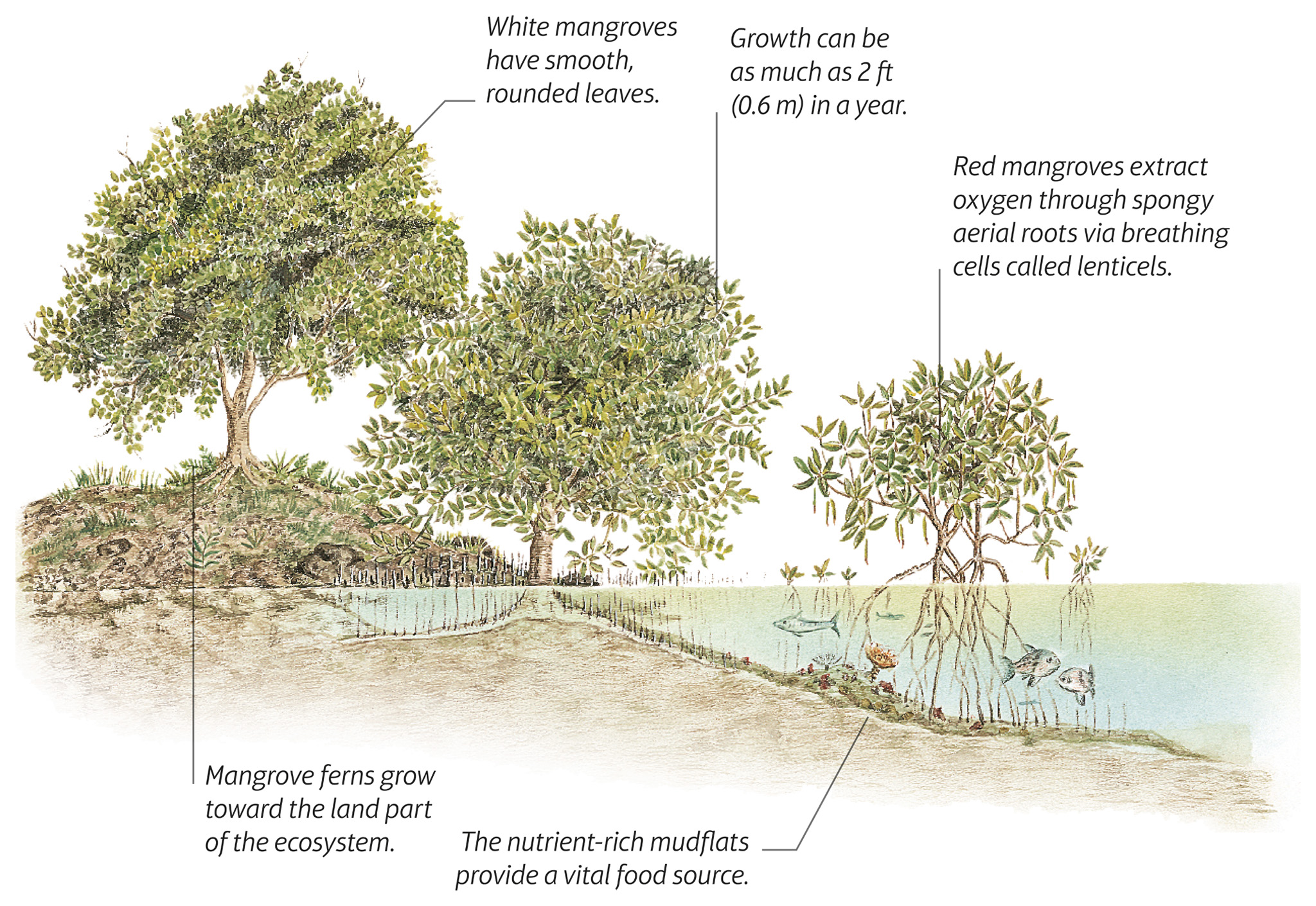
Costa Rica’s shores contain five of the world’s 65 species of mangroves – black, buttonwood, red, tea, and white. Mangroves are woody halophytes – plants able to withstand immersion in saltwater – and form swampy forests in areas inundated by tides.
THE MANGROVE ECOSYSTEM
Mangrove forests are of vital importance to the maritime ecosystem, fostering a wealth of wildlife. They grow up and down Costa Rica's Caribbean coastline thanks to pendulous seed pods that drop and float away at high tide to begin a new colony.
The tangled roots buffer the action of waves, preventing coastal erosion. They also filter out the silt washed down by turbulent rivers. The dense mud leaves
little oxygen, and nutrients are supplied by decomposing leaf litter lying close to the surface. As a result, most plants develop interlocking stilt roots that rise above the water to draw in oxygen and food. The nutrient-rich mudflats that form around their roots, creating a food source for marine creatures, while the roots themselves create protective spaces for eggs and young to develop away from predators.
THE RICH FAUNA OF THE MANGROVES
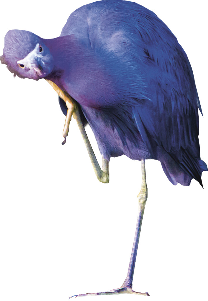
t A curious, vivid little blue heron considering its options in the mangroves
In the nutrient-rich muddy beds of coastal mangrove forests, microorganisms flourish. These tiny creatures foster the growth of larger animals such as shrimps and other crustaceans, which in turn attract various species of mammals, reptiles, and birds.
The dense, protective root system acts as an aquatic nursery for oysters, sponges, and other invertebrates, as well as numerous fish species, including sharks and stingrays, which thrive in the murky tannin-stained waters. The roots also protect baby caimans and crocodiles from predators, while at the same time providing them with a plentiful food source. Larger species, such as raccoons, coyotes, snakes, and wading birds forage along the shoreline for small lizards and crabs.
The upper branches of the mangroves provide well-placed roosting spots for many species of birds, especially frigate birds and pelicans, and a number of endemic species including the yellow mangrove warbler.