
Chapter 16. Where in the World?
It’s a beautiful day in this neighborhood. A beautiful day for a neighbor. Would you be mine? Could you be mine?
—MR. ROGERS’ NEIGHBORHOOD
TUBBS: I haven’t seen you before. Are you local?
MARTIN: No, I’m meeting up with a friend actually—going hiking.
TUBBS: Don’t touch the things! This is a local shop for local people, there’s nothing for you here!
TUBBS: Edward! Edward!
EDWARD: Hello, hello? What’s going on? What’s all this shouting, we’ll have no trouble here!
TUBBS: I caught him stealing from the shop.
EDWARD: Who is he? Is his identity known?
TUBBS: He’s not local.
—“THIS IS A LOCAL SHOP,” SKETCH BY LEAGUE OF GENTLEMEN, BBC
The Local Connection
ONE OF THE THINGS WE LIKE TO DO AS SOCIAL CREATURES IS TO PLAN EVENTS AND GATHER IN GROUPS. Lunches, dates, meetings, playdates, parties, weddings—even funerals—and events to punctuate the week and celebrate milestones and major life events are all occasions to gather people together. Events have become easier to plan with a variety of online tools, and with the explosion of social tools, they can be more collaborative than ever. Invitation tools and calendaring are two of the oldest applications available online. The addition of the social graph and other rich social tools continues to keep these tools relevant, and now we see these features creeping into mainstream social networking sites such as Facebook and LinkedIn.
The rise of the smartphone and geo-capable mobile devices means that we can be connected and location-aware regardless of where we are. Location capabilities such as geo-tagging, geo-mashing, and even neighborhoods provide a context of place around what we are doing online. Although people might be generally drawn together based on interests or on activities, the natural progression of a community will eventually lead people to get together in real life. The crossover of interests and desire for face-to-face meetings is powerful and really useful. Without explicit interactions to facilitate meeting in person integrated into interest sites, people will still figure out how to bring groups together—only it will be cumbersome and might require the use of multiple sites, along with email, texting, and old-school phone calls. Incorporating event-creation and mapping into these tools makes this much easier for people.
The following patterns—when added to things such as identity, presence, and activities that can include forums, collections, and groups—create a rich suite of tools that we can combine to help bring people together, whether they actually know one another or not.
You should take care to protect your user’s privacy and give them control over who sees where they are located at any given time; be sure to use their location information only in a way that enhances the experience. (Remember the Ethical Dimension we discussed in Chapter 2?)
Being Local
What
The user wants to use online social tools to facilitate offline events and meetings in her location, as depicted in Figure 16-1.
Face-to-Face Meeting
What
The user wants to meet offline with people from his network, in a nearby location, as demonstrated in Figure 16-2.

How
Provide users with a mechanism to create events and invite participants.
Pre-event creation
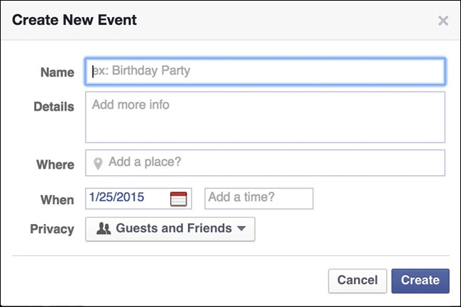
Give users a method to enter full details of an event, including location, time, date, details, and special considerations, as shown in Figure 16-3.
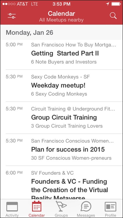
Integrate a calendar (see Calendaring) for scheduling time-based events, as presented in Figure 16-4.
Give event creators the option to mark an event as public or private (see Figure 16-5 and Figure 16-6).
Provide functionality for users to select locations from a list of places, for example, from city guides, yellow pages, or other directories.
Consider indicating nearby establishments, such as restaurants, parking, coffee shops, ATMs, or other relevant businesses, which accommodates comprehensive planning.
Provide the full address, phone number, and other relevant details, such as costs, hours, restrictions, or ambiance.


Pre-event attendees
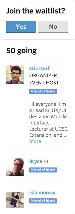
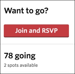
Make it possible for users to RSVP to events. Consider showing RSVPs to other users and indicating attendees from a viewer’s network (see Figure 16-7 through Figure 16-9).
Figure 16-7. Meetup shows who else is attending, whether they are in your network or are friends of friends.Consider accommodating public events to which users can invite themselves or follow an event.
Consider adding capabilities for collaborative content creation.
Integrate maps for selecting and displaying locations (see Geo-Mapping or Near Me Now).
Include a way for users to indicate a method for receiving alerts or reminders for events (see Reminding).
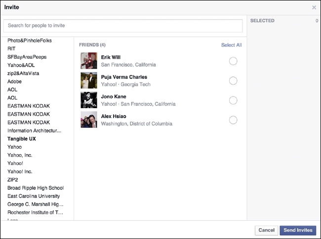
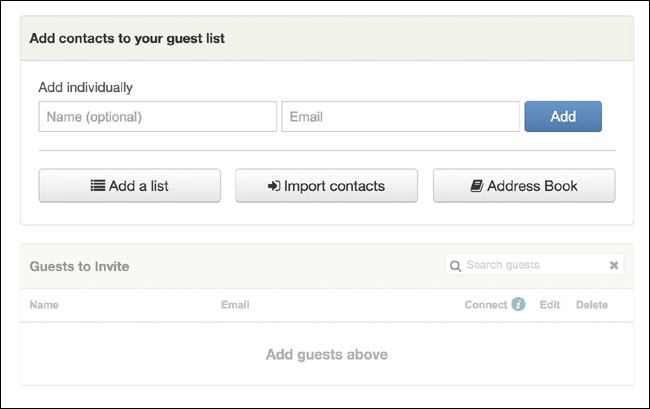
Give users the ability to easily invite their network or a subset of their network to an event, as depicted in Figure 16-10. Consider a batch invite process, such as multiselect, for sending invites.


Post-event attendees
Provide functionality for users to attach photos to the event..
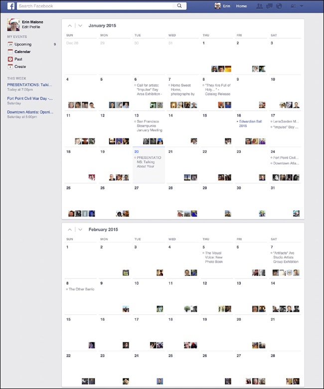
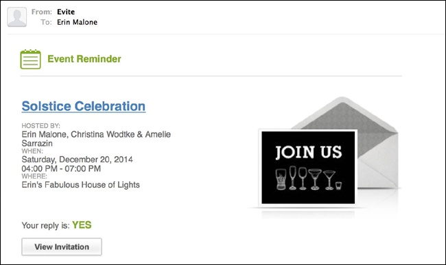
If the user attended (or RSVP’d “yes”), show the event in his calendar of past events, as shown in Figure 16-11.

Public events
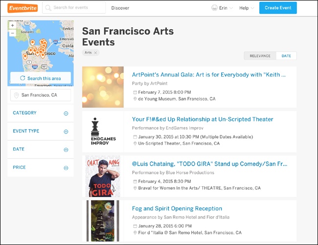
Make events searchable by keyword/category, tags, and date.
Include a mechanism for users to browse through events and filter by keyword/category, tags, and date, as illustrated in Figure 16-12.
Show users a list of events being attended by friends in their network (see Figure 16-9).
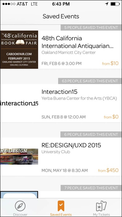
Give users a way to save events they are going to or in which they are interested. (see Figure 16-13)
Semipublic events
Indicate whether the user must be part of the network in order to RSVP or attend the event, as shown in Figure 16-14.
Related patterns
Party, described next
As seen on
Facebook (http://www.facebook.com)
Meetup (http://www.meetup.com)
Eventbrite (http://www.eventbrite.com)
Evite (http://www.evite.com)
Google+ (plus.google.com)
Party
What
The user wants to plan an event and invite friends to join the party, as shown in Figure 16-15.

Use when
How
Preparty planning
Provide the means for users to enter full details of an event, including location, time, date, details, and special considerations, as depicted in Figure 16-16.

Use a calendar picker for easy date selection and minimization of data entry errors (see Calendaring).
Offer to add the event to the user’s calendar (Yahoo!, iCal, Google, etc.).
Make it possible for event planners to poll invitees through the use of simple polls.
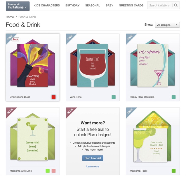
Provide templates for invitation display. Give the event creator options to choose a theme that is appropriate to the theme of the party, as presented in Figure 16-17.
The event creator should be able to invite multiple people at a time. Provide a field for adding multiple email addresses.
The user should be able to select from her desktop address book, as demonstrated in Figure 16-18.
Provide a way for the user to make guest selections from her online address books and social networks, such as Google, Yahoo!, Facebook, LinkedIn, and Twitter.
Include an option for the event planner to save the email addresses for later use.
Invitees
Offer to add the event to the user’s calendar (Yahoo!, iCal, Google, mobile calendar applications if not native iOS or Android).
Consider showing RSVPs to others and indicating attendees.
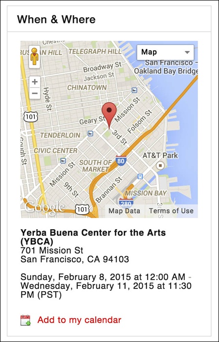
Show the event on a map, as is done in Figure 16-19.
Consider indicating nearby establishments, such as restaurants, parking, coffee shops, and ATMs, to accommodate comprehensive planning.
Show the full address and phone number of the location.
If the event is at a public location, such as a restaurant or park, show details about the location: hours, ambiance, restrictions, and so on.
After party
Why
Giving users the tools to create offline events enhances relationships that previously might have existed only online. People want to gather, and they will use whatever tools are available to coordinate the event. Bringing this functionality into your site (if appropriate) will keep users engaged and can create a holistic experience that moves seamlessly from online to offline and back online again.
As seen on
Evite (http://www.evite.com)
Facebook (http://www.facebook.com)
Punchbowl (http://www.punchbowl.com)
Eventbrite (http://www.eventbrite.com and Eventbrite mobile)
Calendaring
What
A user wants to find or submit an event (public or private) based on a date or within a certain date range, as shown in Figure 16-20.
Use when
You want to find events by date.
Use this pattern with Face-to-Face Meeting and Party.
How
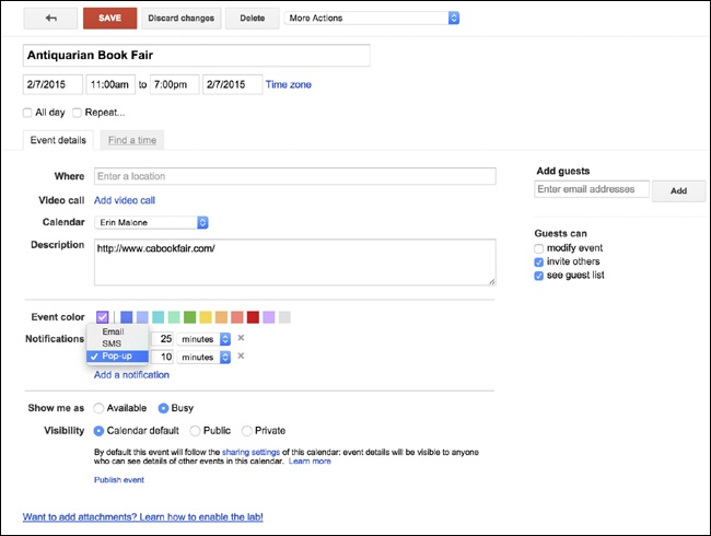
Make it possible for users to associate an event with a date. You can do this through an event-planning interface or within a calendar interface (see Figure 16-21 and Figure 16-22).
Give the event creator the means to indicate whether the event is public or private.
Make it so that the calendar event can be shared, whether through direct selections from the user’s network, through email, or through RSS, blogs, or other social offerings.

Selecting a specific date
When selecting an associated date for an event, give the user the option to either type in the date or choose the date with a calendar picker.
By providing the calendar picker, the user can see the date in the context of other dates and the day of the week, and it ensures fewer data entry errors.
Calendar details
Provide a title and description field.
Provide a notes field for URLs and other information.
The user should be able to associate a location to the event, as presented in Figure 16-23.
When the details are complete, display the event in all presentations of the calendar (i.e., list view, day view, week view, and month view).
Present the title, location, and as much of a description as appropriate for the display. For example, the list view would display most, if not all, of the description, whereas the month view might show only a truncated title.
Use rollover panels to display the full calendar event without forcing the user to click.

Why
Events are time constrained, and including robust online calendaring tools will make creating parties, events, and face-to-face meetings easier to plan.
Provide enough functionality to be useful without creating an entire enterprise-level application.
As seen on
Evite (http://www.evite.com)
Facebook (http://www.facebook.com)
Google Calendar (http://www.google.com/calendar)
Punchbowl (http://www.mypunchbowl.com)
Reminding
What
A user needs to know when an event is happening, as demonstrated in Figure 16-24.
Use when
How
When creating an event, give the user the ability to set reminders or alerts about those events.
If the event creator is inviting attendees, set the reminder to automatically send alerts to the attendees.
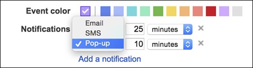
Give the user the ability to select from a preset list of reminder times. For instance, Yahoo! Calendar offers to send reminders from 14 days before the event all the way to 5 minutes before the event. With Google Calendar, you can specify an exact number and then it qualifies that number with minutes, hours, days, weeks, months, etc. (Figure 16-25).
Users should be able to send Reminders to an email address and to mobile devices or added to a social networking profile.
Consider allowing two reminders to be set, for example, 14 days and 5 days in advance of the event.
For public events, give people a way to set their own reminders.
As seen on
Evite (http://www.evite.com)
Facebook (http://www.facebook.com)
Google Calendar (http://www.google.com/calendar)
Geo-Tagging
What
A user wants to annotate a person, place, or thing with a geographic tag, usually in the form of latitude/longitude, which is then translated into an address that can be placed on a map, as demonstrated in Figure 16-26.
Use when
Use this pattern when you want to place objects (people, places, or things) on a map or associate location data with the object.
How
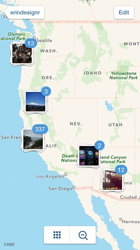
If the item is a photo and there is Exchangeable Image File (EXIF) data that includes latitude/longitude information, associate that location string with the object, as shown in Figure 16-27.
Automatically place the item on a map.
If the item has an address associated with it, such as a business, automatically place the item on a map.
Give the user the option to associate an address with an object.
Consider providing users with drag-and-drop capability to place items (photos, listings, friends) onto a map and associate a location with the item.
Offer an address form so that the user can refine the location. Provide fields for the full address, a city/state combo, or even a zip/postal code. Fields should be optional.
Give users a method to enter specific latitude and longitude numbers indicating a point on a map as an alternative to picking a spot on a map (Figure 16-28).
Use the World Wide Web Consortium (W3C) format for geo data—for example, geotagged geo:lat=57.64911 geo:lon=10.40744. The first item is the tag “geotagged”, allowing all items to be searched from a common tag. The other tags are “geo:lat” and “geo:long”.
Convert geotags into user-friendly addresses when presenting locations in the interface.
Clearly indicate how the information will be used and be clear about what is private and what displays publicly.

Why
By offering geo-tagging capabilities for assets, particularly photos and videos, these assets can exist not only in time but also in a context related to the real world. Placing images on a map gives people a sense that this image really exists and that they might see this, too, if they were to go there. Geo-tagging also announces to a person’s network that she was there, at this spot.
As seen on
Path mobile application
Flickr (http://www.flickr.com)
Swarm mobile application
Facebook mobile application
Geo-Mapping or Near Me Now
What
A user wants to see where he is, where his stuff might be, or where his friends are in relation to himself or other people and places (see Figure 16-29).
Use when
How
Present the item location with a graphic pointer on the map.
Display other people or items on the map in relation to the user (if the user is on a mobile device or has indicated his location). Provide search functionality for the user to look for items based on location.
Give users the option to plot themselves on a map or announce their locations.
Users should be able to turn off presence or location indicators.
Show nearby businesses or events of interest relative to a user’s location.
Gatherings
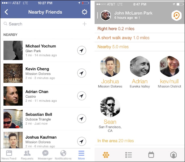
Using a combination of geo-location and text messaging, users can easily pull together an impromptu gathering. Services such as Swarm and FindMyFriends offer the ability to see yourself and those in your network plotted on a map, as depicted in Figure 16-30.
Give users an easy way to see where their network is located (with permission, of course; see The Ex-Boyfriend Anti-Pattern) and send out a message or invitation to meet up to those people.
Include the means for users to send out one message to a predefined group of people.
Consider the option for users to send out one message to a group pulled together on the fly that is based on proximity.

Why
Providing easy tools for placing items or people on a map can offer alternative ways to filter objects on a site or application.
Showing items on a map based on current location of a device can provide contextually relevant information and can help support local, face-to-face meetings and gatherings between people.
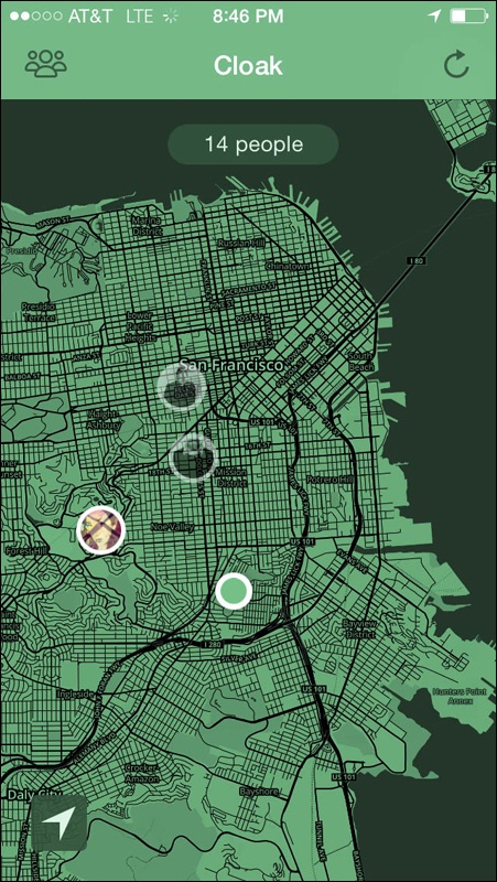
Showing people in a network on a map can also make it possible for users to avoid accidently running into people or to go incognito if needed, as illustrated in Figure 16-31.
Considerations
The CTIA, an international mobile industry body, has published a set of best-practice guidelines for location-based service applications (http://bit.ly/1IKTSiq). Two fundamental principles guide the document:
- User notice
Location-based service providers should inform consumers as to how their location information will be used, disclosed, and protected so that users can make informed decisions about whether to use the service or authorize disclosure.
- User consent
After users have selected location-based services or authorized disclosure of their location information, they should have choices as to when or whether location information will be disclosed to third parties. Users also should have the ability to revoke any such authorization. Provide the ability for sharing location at the point of upload, or interaction and not just in settings or other hidden-away interactions.
As seen on
Cloak mobile application
Instagram mobile application
Find My Friends mobile application
Geo-Tracking or Where I’ve Been
What
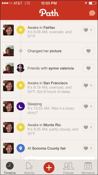
A user wants to see and share where she has been over time, as shown in Figure 16-32.

Use when
Use this pattern to track a route over time.
How
The user should be able to select a starting point or indicate a start time and end.
Pair route information with elevation. This is becoming more common with data-tracking athletic services and applications.
Give the user an option to save a route for later.
Include an option for the user to share her route with friends.
The user should be able to make her route public or keep it private.
Why
Route tracking is relatively easy with the latest mobile and wearable devices. Route information is just one set of information that has become popular on personal data dashboards and profiles (see Profile). Users are collecting personal data and want to make comparisons of that data over time as well as wanting to track their children or pets.
As seen on
MapMyRide mobile application
Strava mobile application
MapMyDogwalk mobile application
FindMyKids-Footprints mobile application
Neighborhood
What
A user wants to know what’s going on around her neighborhood, as demonstrated in Figure 16-33.

Use when
Use this pattern when pulling together geographic or place-specific content.
How
Give users the ability to select a neighborhood for filtering information. The neighborhood boundaries should include relevant location definitions, including zip code, school districts, explicit metadata, or location keywords.
Present the option to connect to people from the same neighborhood or in nearby areas.
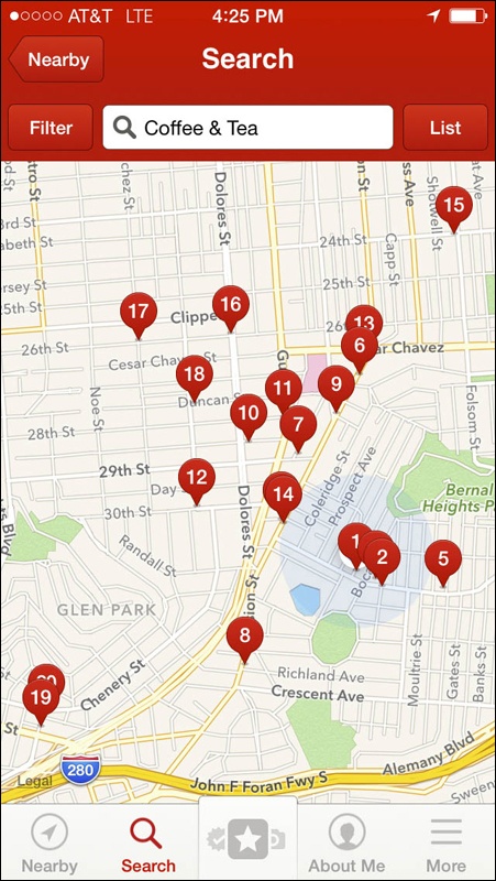
Provide functionality for people to search by neighborhood, zip code, or other relevant location data, as shown in Figure 16-34.
Provide an easy mechanism for users to switch neighborhoods (see Figure 16-35).
Consider mashing up a variety of interesting and relevant content related to the selected neighborhood. The types of content that can be pulled together include photos, news items, business listings, real estate listings, police blotter announcements, ratings and reviews of businesses, parks and public places, events, and people.
Display the user’s location on a map.
Display relevant content on a map to indicate proximity to the user.

Further Reading
Best Practices and Guidelines for Location Based Services, International Association for the Wireless Telecommunications Industry, http://bit.ly/1IKTSiq.
Sheridan, Barrett. “Digital Hide and Seek: Are you ready for social mapping?” Newsweek Web Exclusive, originally published August 14, 2008. http://www.newsweek.com/id/153197/.
Honan, Mathew. “I am Here: One Man’s Experiment With the Location-Aware Lifestyle.” Wired Magazine, originally published January 19, 2009. http://wrd.cm/1eAzqso.
Masters, Harvey P., ed. “Location Based Services: Developments and Privacy Issues.” June 2014, Nova Science Pub Inc.
Gilbertson, Scott. “Take Your Geo-Mashups Beyond Google Maps.” WebMonkey, originally published October 17, 2008.