
Let's learn a bit more on GPS as it powers all the current LBS implementations. If you are building the next generation navigation software or your own mapping applications, it is the right time to know more about GPS and how it works, so that it helps you make key decisions for your application.
GPS has three major components as shown in the next diagram (diagram courtesy Jörg Roth: http://www.wireless-earth.de/jr_eng.html): user segment (GPS receivers, mobile phones, car navigation units), space segment (24 satellites in orbit), and the GPS control segment having a base on Earth with the Master Control Station (MCS) in Colorado Springs, Colorado (so now you know where to head to get a clear signal!)
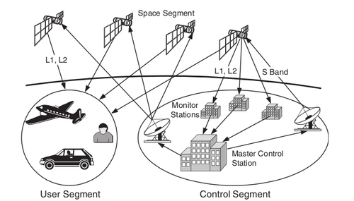
The user segment comprises of the GPS receivers embedded in millions of pieces of military equipment, almost all cell phones these days, aircraft and car navigation systems.
The space segment comprises of the satellites orbiting Earth. The 24 satellites move in six different orbits around Earth at a distance of 20,200 km.
The satellites move in a manner that at every point of the earth's surface at least five and at most eleven satellites are visible over the horizon, for maximum accuracy.
The control segment is the base on earth that controls the functioning of the GPS satellites and passes on the administrative commands such as correcting the satellite orbit and internal data. Several monitoring stations receive the satellite signals based on their location; they are synced with atomic clocks to calculate the correction data. This corrected data is then sent to the Master Control Station.