
Introduction
As communities face the intersecting nature of sustainability’s three primary dimensions, they begin to view change as likely, or even necessary, to their holistic well-being. If they face the threefold challenge as an opportunity to build a vibrant, clean, and fair community, they can do more than address sustainability. They can begin to build resilience.
As defined by Luthar (2006), resilience refers to the ability to make a positive adaptation when faced with a significant adversity. Fleming and Ledogar (2008) note that the word resilience is derived from a Latin term meaning to “jump back up.” In other words, resilience refers to the capacity to rebound. The notion was first employed to address an individual’s psychological capacity to deal with stress. Later, it was employed to explain the capacity of a community or cultural group to adapt and reorganize itself while retaining key elements that preserve its distinctness (Healy 2006). The concept has also been used for some time by scientists who refer to ecological resilience as “the amount of disturbance that a system can absorb” (Gunderson 2000, 426).
As sustainability scholars, we can employ resilience as a concept that defines our ability to rebound from both foreseeable and unanticipated stressors, especially ones that link our economic, environmental, and social well-being. In this chapter, we will first examine water laws in Montana, which can easily pit individuals against one another. As a matter of resilience, it seems we need to examine our mechanisms for sharing water, especially if we intend to rebound from prolonged and severe droughts. As people and industries call for more water, it may be increasingly difficult for our communities to thrive and developing water-sharing plans before they are needed would enhance our adaptive abilities during a crisis. Later in the chapter, we will examine why our resilience may require us to separately address consumptive and non-consumptive uses of water. Finally, we will examine how the channel migration processes, riparian areas, and floodplains associated with the Yellowstone River are used and adapted. We will see that we are not holistically improving our resilience along the valley floor, even though our long-term well-being depends on our willingness to do so. These examples make clear that resilience must include the intersections of economic, environmental, and social well-being.
Water Is a Shared Resource
Throughout the American west, water is considered a scarce and precious resource. In Montana, the refrain, “Whisky’s for drink’n, and water’s for fight’n!” rings especially true. Indeed, the first criminal case tried in Montana, Territory v. Drennan, was for a shooting involving two irrigators fighting over water (Knowles 1868). Here, we turn our attention to only a few of the many, many details about Montana’s water laws and water rights. We will see that fairness in water rights is especially difficult to define because some of the rules reflect priorities set in the 1870s. Efforts to reimagine the rules—even slightly—threaten long-standing cultural assumptions and economic investments. Public and private rights certainly intersect in the context of water laws.
To begin, consider how clearly Montana’s constitution lays out the state’s unambiguous claim to water as a public resource:
All surface, underground, fold and atmospheric water within the boundaries of the state are the property of the state for the use of its people and are subject to appropriation for beneficial uses as provided by law. (Constitution of the State of Montana, IX-3)
As property of the state, ownership of water is never transferred away from the state. Rather, water rights can be assigned when the water will be put to a “beneficial use.” In Montana, a water-right holder owns only a right to use, and that right is defined in terms of use, amount, and the spatial and temporal limits of the appropriation (Water Policy Interim Committee 2018).
When water is abundant, appropriations can be made to almost anyone for almost any reason. However, in practice, the late summer months present challenges as water is not consistently available for everyone. Many in the valley express concerns about water availability. The Yellowstone Basin Committee, a planning group that convened in 2013, identified as their top two priority concerns: water availability and drought readiness (Gilbertz, Hall, and Ward 2013). As one farmer said, “We need to make people aware that water is a finite material” (Irrigator near Forsyth 2013).
A key concern for rights holders is the clarification of whose rights will supersede when there is not enough water for everyone. When water supplies are inadequate to serve all the rights holders, the prior appropriations doctrine determines who will receive water and who will not (Montana Department of Natural Resources and Conservation 2015b). This doctrine makes it a priority to provide water to the holder who has been using water the longest. In other words, an older appropriation of water will supersede a later appropriation (Water Policy Interim Committee 2018). Understood throughout the American west as “first in time, first in right,” the rule prioritizes those with senior rights, and junior rights holders can be forced to stop using water.
Unfortunately, the early bookkeeping regarding legitimate rights and dates of appropriation were messy and easily challenged. In the 1970s, efforts were made to clarify rights as three sets: early rights (essentially guaranteed), rights acquired after implementation of the Montana Water Use Act of 1973 (rights with clear documentation), and the 1978 state-defined water reservations (which defined the rights of eight municipalities, six state and federal agencies, and Conservation Districts with linkages to irrigation projects) (Water Policy Interim Committee 2018). The Montana Water Court, established in 1979, was created to sort out claims and dates of appropriations. It has been busy ever since. Perhaps, then, it was predictable that even in 2013 the basin planning group identified enforcement and protection of senior rights as their third top concern (Gilbertz, Hall, and Ward 2013).
There are two historic bases for Montana’s contemporary application of the prior appropriations doctrine. First, the doctrine was confirmed by the Sixth Legislative Assembly of Montana Territory (1870) and was subsequently codified in the Territorial Statutes of 1872. The statute reads, in part, “All controversies respecting the right to water in the territory … shall be determined by dates of appropriation” (see Holloway 1921). This explication, confirmed by the Montana Supreme Court in Mettler v. Ames Realty Co. 61 Mont. 152, 201 (1921), protected the White settlers, farmers, and miners who had already arrived and who were already using water.
Second, the doctrine is an underlying principle in the 1872 General Mining Act (GMA), which codifies first mining efforts as priority efforts, meaning whoever first claimed a particular mining location would have the only legal right to develop that location (Squillace 1988). The GMA implicated water rights, too. Given that most mining activities in the late 1800s were conducted via panning or placer techniques, water was needed (Heman 1949). Early miners moved water to the location of their mining claims out of convenience. It was easier to move water to the claim, via canals, sloughs, and sluices, than it was to move the mining materials to the water. Thus, early mining claims and water claims were inherently connected (Bakken 2011).
Some of the early laws and declarations, put in place to protect early White settlers, are mostly still in place today. For instance, in Montana, the application of the beneficial use mandate remains lenient, both in law and in practice. As was true in the 1800s, the state continues to approve wide-ranging uses. Thus, while it is not beneficial to run water downhill simply for the sake of running water, it is beneficial to use water to grow sugar beets, to raise cattle and sheep, to cool oil refineries, to provide water to municipalities, and to run waterslides. Notably, in Montana, no use, or set of uses, is explicitly prioritized over other beneficial uses.
Another concern regarding water rights in Montana is their transferability. A person holding a water right will often transfer that right with land to a buyer or an inheritor. However, the water right can also be severed from the land estate and transferred independently. Water rights can be sold, in and of themselves (Marketing Water Rights n.d.). It is possible that one might own land in Montana where a natural stream runs across the property but not have a right to use the stream’s water. The state will formalize the transfer of a water right and its priority date so long as the amount, use, and spatial and temporal delineations of the right remain unchanged. If any of those criteria change, a review must follow to determine if the change will negatively affect other rights holders. In cases where a detrimental impact to other users is expected, the transfer can be denied or the date of appropriation will change to the current date, rather than the historical date. Even though it appears that water has become a commodity, remember the state still holds the water as property. It is the water right that is commodified. In this system of exchange, senior rights are more valuable than junior rights. If one needs water, it is strategic to purchase the oldest right available.
American Indian Water Rights
Montana’s water laws have evolved in several ways. In 1908, a famous case was settled by the U.S. Supreme Court in favor of American Indians, establishing their rights to water as Federal Reserved Water Rights. The case, Winters v. United States 207 U.S. 564 (1908), involved a conflict on the Fort Belknap Indian Reservation of Montana, home to the A’aninin and the Nakoda nations. The court’s decision clarified that, “when the United States sets aside an Indian reservation, it impliedly reserves sufficient water to fulfill the purposes of the reservation, with the priority date established as of the date of the reservation” (U.S. Department of Justice 2015). Throughout the United States, the Winters Doctrine established that, at the very least, the minimal water needs of the people living on the reservations must be met.
The limits of water resources were even more of a concern to the people of the Yellowstone River basin in the 1970s because plans to use water for coal development were being widely discussed. Wyoming, Montana, and North Dakota had ratified the Yellowstone River Compact in 1950 (U.S. Geological Survey n.d.c), and the agreement defines how these three states are supposed to share the water supplies of the drainage. Given that both Wyoming and Montana were anxious to develop coal reserves, the compact would, in great measure, determine where such development might occur. Tribal interests were also in play because the tribes were considering developing coal reserves on reservation lands. Importantly, the interstate compact indicates that the states’ shares would be “reduced by the shares of water apportioned to the Northern Cheyenne, the Crow, and the Wind River reservation[s]” (Bach 1982).
As a unit of measure, and of water sharing, one must understand “acre-feet,” which is a large-scale measure used for water. Specifically, the amount of water needed to cover one acre of land with 12 inches of water is defined as one acre foot. In 1975, the U.S. Department of the Interior projected that by the year 2020, water withdrawals by the Crow and the Northern Cheyenne tribes would total 2.1 million and 500,000 acre-feet per year, respectively (Bach 1982). Tribal rights threatened nontribal water rights holders. One legal scholar explained the situation in 1982 in these terms:
The reserved rights of the Indians have not been quantified. Under the Winters Doctrine, the Indians would have command of the beneficial use of the lands and waters located on the reservation, including necessary uses for the “arts of civilization.” This would theoretically include the water necessary for the development of the coal reserves located on the reservations. (Bach 1982, 189)
Indeed, in 1975, the Northern Cheyenne filed a federal suit asking the court to quantify the totality of their water rights (Compact Implementation Program n.d.). Assuming their date of appropriation followed from establishment of their reservation lands, they would have a very senior water right regarding use of water from the Tongue River and Rosebud Creek. As senior rights holders, the tribe would be able to use water in any variety of development projects. Their suit was later dismissed when the U.S. Supreme Court determined that states, not the federal courts, should sort out disputes regarding reserved water rights.
Since then, it is primarily through state adjudications that the full extent of the Indian Reserved Water Rights has been determined—state by state and, typically, tribe by tribe. Because Montana had seven reservations, each with its own claims to water, in 1979 the Montana Legislature created the Reserved Water Rights Compact Commission (RWRCC). The primary task of this commission was to negotiate compacts regarding tribal reserved water rights. In the same sense that states address water disputes via interstate compacts, the commission would negotiate compacts with the tribes that would be used to settle tribal claims to water (Montana Department of Natural Resources and Conservation n.d.). Each compact would require approval of the Montana Legislature, the U.S. Congress, the tribal community, and the Montana Water Court. Further, even though the states were supposed to negotiate the settlements, in 2019 federal legislation was introduced to provide two billion dollars to settle a tribal claim in the Flathead Basin (U.S. Congress 2019).
Efforts to negotiate the compacts were decades in the making, but the RWRCC generally succeeded in drafting compacts with the tribes of each reservation (Compact Implementation Program n.d.). However, tribal water rights are, to this day, not yet fully resolved as agreements in Montana. In several cases, the processes are incomplete because the approvals are not yet secured. A great deal of state and federal legislative energy has been put into the approval process, but nontribal rights holders, whose claims had previously been senior in definition and whose priority dates are threatened by the confirmation of tribal rights, have asked the legislative bodies to not ratify the compacts (Stern 2019). Ironically, some of the same people who previously staunchly subscribed to the notion of prior appropriations have been threatened by “new” senior rights.
In Montana, the Crow Nations and the Northern Cheyenne now have defined water rights (Compact Implementation Program n.d.). The Crow Reservation has several defined rights with the oldest priority date listed for the tribe as July 25, 1868 (Crow Compact 2011). Among its many water-rights provisions, the agreement allows the Crow to take 500,000 acre-feet of flow from the Big Horn River, annually (Compact Implementation Program n.d.). Highlights in the Northern Cheyenne agreement include an October 1, 1881 priority date and, with some limits, the rights to 32,500 annual acre-feet of direct flow from the Tongue River.
Another set of water rights issues are also worthy of attention. Namely, issues regarding water availability and the rights of nonhuman entities. By the 1960s, irrigators, exercising their water rights, were known to completely de-water certain streams in the watershed during the late summer, and it was concerning to some people that the fish in public streams had no legal claim to water. Murphy Rights were approved by the legislature to protect Montana’s Blue-Ribbon trout streams (Montana Department of Natural Resources and Conservation 2015a). With a December 1970 priority date, these water rights provided instream flow protections for 12 of Montana’s rivers, including the Yellowstone River. Further protections for instream flows were established for the Yellowstone River and its tributary streams in the late 1970s, 1980s, and 1990s (Water Policy Interim Committee 2018). However, there is no clear scientific basis for establishing flow thresholds (Bradford and Heinonen 2008), and the State of Montana has not set specific parameters for how to determine the minimum flow needed by fish. The limits of the instream flow protections have also not been fully vetted. For instance, irrigators were not asked to forgo withdrawals of water in 2016, even though the PKD outbreak discussed in Chapter 2 was, at least in part, a function of extremely low flows.
It is apparent that the resilience of the communities of the valley will depend on how water resources are shared. If we pause to think carefully about water rights, we might begin to wonder if we can afford to continue to think of all uses of water as equally beneficial. We might consider if, or how, we will accommodate claims as new or expanding water uses come into view. One resident from Billings complained at an open meeting, “Montana should stop handing out water appropriations” (Public Scoping Participant from Billings 2013). As it is, legislative and compact closures are enforced in some of the subbasins, which stops further allotments (Montana Department of Natural Resources and Conservation 2016), but in many circumstances, a water right can still be approved in the Yellowstone River Valley.
Our resilience will also be defined by how we manage drought. Within the agricultural communities of the valley, conservation ideals, commitments, and agendas are often drought sensitive (Horton et al. 2017), but only some irrigators have plans in place to address shortages:
I think we’re fairly prepared. We have water rationing plans in place, and the producers are well aware of them … Everybody will be given less, a smaller allotment … So, it’s up to [each producer] to make a decision about what is economically best in terms of which crop you would like to save and which crop is going to suffer. So, it’s the individual farmer that makes that decision in the end. I suppose [the rationing plan] has been in place for twenty years, but it’s been fine-tuned a little bit more in the last seven or eight. (Farmer near Savage 2018)
Water rights are especially precious under conditions of overallocation, and any new water-dependent industry will need to find rights holders who are willing to forego, temporarily or permanently, their own interests in water allocations. It is notable that the producer’s drought-mitigation plan, mentioned previously, applies only to a certain group of irrigators. The Yellowstone River Basin Water Plan (Montana Department of Natural Resources and Conservation 2014) calls for efforts to prepare for drought, more generally. However, little has been done to move this agenda forward. The state posts data concerning drought conditions each summer, but the most recent statewide drought plan was written over 25 years ago (Montana Department of Natural Resources and Conservation 1995).
Of interest is a key provision in the compact with the Crow Nation. Their agreement specifies commitments to “share shortages” during low water years (Compact Implementation Program n.d.). The shortages clause helped move the approval processes forward because it tempered the potential impact of the tribe’s seniority rights on other rights holders during a time of drought. The clause also illuminates an important lesson: if one understands water as a shared resource, then one should also understand water shortage as a shared burden.
Many activities in the valley eventually return used water to the overall supply. In the language of water management, these are known as nonconsumptive uses. For example, the municipalities along the Yellowstone River that pull water directly from the river for their communities also return water to the river via their wastewater treatment plants. The returned portion is the nonconsumptive-use portion. The extensive irrigation projects of the valley are estimated to return 80 percent of their withdrawals via subsurface flows and return outlets (Cannon and Johnson 2004). In this way, water can be used again and again.
Now, let us return to the oil and gas fields. You will remember that drilling and hydraulic fracturing require water, and that in the Bakken region drilling companies need one to five million gallons of water per well. Since the 1950s, local farmers have sold water to the oil and gas companies. The drilling companies, most of which are headquartered in other states, do not wish to purchase water rights in Montana. Rather, they seek to simply purchase water in locations near their drilling sites. Water sales are advantageous to the local farmers, who supplement their farm income by selling water, but not their water rights, to drilling companies. Farmers do not wish to sell their water-use rights because that would amount to a permanent transfer of the water right, and they would be left without a long-term future. They know that every oil boom eventually goes bust. When that happens, farmers simply go back to farming.
Yet, the sales between farmers and the oil and gas industry are often in violation of the water rights laws. Namely, water appropriated for irrigation purposes should not be used for oil and gas production. In some cases, the sales are from irrigation supplies and in some cases from groundwater wells generally permitted for livestock and/or household uses. During the Bakken boom (2000–2010), the practice of selling water for oil and gas development was so widespread that authorities could see no means to enforce the law. Instead, water authorities petitioned the legislature to change the law. It is now possible to request Temporary Permits that allow farmers to legally, temporarily, change the designated uses of their water rights. The code explicitly states, “Temporary uses include water needed for oil and gas exploration” (Water Policy Interim Committee 2018, 28).
There is, however, another important issue with these temporary water-right uses. Flood irrigation practices, as seen earlier in this case study, charge shallow aquifers and return a great deal of water back to the river itself (Figure 5.1). In contrast, drilling and hydraulic fracturing generally result in the permanent loss of water. Water that backflows from an oil or gas well is considered wastewater, and the drilling companies can permanently dispose of the wastewater as an industrial by-product. They do so because they consider it cost prohibitive to treat the water such that it could be used again. The wastewater is disposed of in deep wells, and it will never return to the overall water system. As such, drilling and hydraulic fracturing are generally considered consumptive water uses. Let us compare this consumptive use with agriculture’s consumptive uses.
In 2014, total industrial uses of water in the Yellowstone River Basin, which include uses by the oil and gas industry, were estimated at over 32,000 acre-feet per year. However, as a percentage of the total withdrawals from the river, the industrial amount was calculated as less than 2 percent of all outtakes (Montana Department of Natural Resources and Conservation 2014, 104). In comparison, irrigation outtakes approached two million acre-feet. Assuming an 80 percent return rate, consumptive irrigation uses can be calculated as totaling approximately 366,000 acre-feet. Even if we assume the industrial uses are all consumptive (which they are not), those uses would total less than 10 percent of the consumptive use attributed to irrigation. It is little wonder, then, that during the water planning meetings, representatives from the oil and gas industry were unwilling to allow their industry to be singled out as a the “worst” consumptive users of water.
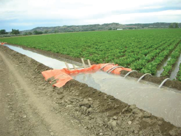
Figure 5.1 Flood irrigation, siphon tubes deliver water from irrigation ditch to rows of sugar beets
When considering the many beneficial uses that are potentially at risk during a water shortage, the valley’s resilience will depend on the agricultural community’s willingness to forgo, at least temporarily, some of their rightful outtakes. “Shared giving” is beginning to find its way into irrigators’ conversations, but state laws make it difficult to offer water as a temporary gift (Anderson et al. 2016).
Our final perspective concerning water as a shared resource comes from the United Nations. As a vanguard of human rights, the United Nations asks us to consider access to safe water to be a basic human right (Van de Lande 2015). We are asked to avoid the commodification of water or of the right to use water. The United Nations opposes cutting off water supplies, even when water bills are not paid. If we think beyond the overallocations of the Yellowstone River Valley and allow ourselves to ponder how we will ensure safe drinking water for 10 billion residents of Earth, the need to share water becomes much more than a local concern—it is a global human concern.
Channel Migration, Riparian Areas, and Flood Zones
Chapter 2 allowed us to narrow our focus to the plights of the Pallid Sturgeon and the cottonwood forests, but the overall health of the river system is much more unwieldy. Here, too, the desires and projects of humans play important roles, especially as human projects seemingly never cease. In the Yellowstone mainstem corridor, development near the river is continuously increasing (CEA 2015). People are charmed by the notion of a free-flowing river, one they imagine as unencumbered, and they want to live near it. As one realtor put it, “Riverfront property is worth a lot, but riverfront with a mountain view is worth the most” (Realtor in Paradise Valley 2008).
Given that undeveloped property is typically taxed at the lowest rate, community leaders are incentivized to allow development. Even a modest house on the river near Hysham will increase local coffers, let alone the multimillion-dollar homes that now populate the riverbanks in Paradise Valley. Thus, local leaders tend to see the economic well-being of their communities as tied to continued development (Robbins, Martin, and Gilbertz 2012). Areas near the river are more popular each year, but developers seldom consider the potential degradations to the river environments these projects will cause over time. Specifically, they rarely factor that development near the river often, either immediately or soon, comes at the expense of channel migration processes and riparian health.
Channel migration is the natural process of river channels changing course. Erosion (a gradual “chipping away” of a riverbank), avulsion (a sudden and profound change in the river course), and deposition (the creation or elongation of sand and gravel bars) are necessary for channel migration to occur (Florsheim, Mount, and Chin 2008). The process is most obvious after high water events. As explained by Hohensinner, Hauer, and Muhar (2018), changes in channel geometry are caused by fluctuating flows and sedimentation. They also discuss channel widening, braiding, and abandonment.
Along the Yellowstone River Valley, the directions and magnitudes of historical channel migrations have been mapped (CEA 2015). The maps also identify areas where the channel is likely to migrate next. Channel Migration Zones have been identified for the entire river corridor. Some Reaches are not expected to involve much migration, whereas others may well soon be sites of wholesale changes (e.g., compare Reach PC19 with Reach PC18). In some cases, the maps have already been proven accurate as predictors of channel movement. Importantly, channel migration is an important process in creating healthy riparian areas.
Riparian areas are produced when the river sweeps across a valley floor, enriching sites with surface and subsurface water and material flows (Gregory et al. 1991). When one flies in an airplane on a clear day, riparian areas are easy to identify. In the Yellowstone River Valley, the verdant path of the riparian areas is especially apparent (see Reaches D11 and D12), and from an overhead vantage, one can make out the contours of the river—sometimes as a single channel and sometimes as multiple channels. In many reaches, the sweep of the river covers acres and acres where channels form, reform, braid, and rebraid themselves (Figure 5.2). A civic leader explained a multichanneled area of the river in these terms, “It’s meander-land, and nobody can own that” (City Official from Big Timber 2006).
Unencumbered channel migration promotes healthy ecological processes. For instance, erosion and avulsion introduce materials into the river, and the subsequent concentration of resources (rich soils and water) creates lush environments and habitats. Fallen trees and released soils contribute nutrients that the aquatic communities require. Debris can play an important role in creating structural habitats for spawning fish. Channel changes (and flooding) introduce temporarily saturated sandbars, hospitable to seedlings. Also, the complexity of the plant communities in riparian areas create varying types and structures of habitat. Shading from trees reduces water temperatures, providing suitable habitat for fish and other animals (Knouft et al. 2021). Indeed, living on the riverbank allows residents to enjoy the aquatic, avian, and terrestrial communities of the riparian areas (Gilbertz, Horton, and Hall 2006). Whether they call it the riparian area or not—and very few do—residents love living in the heart of it. One resident described living with bears as if they were neighbors:
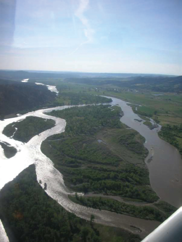
Figure 5.2 The Yellowstone River where it meanders
Last year we had two bears that came through the yard… They were unaware that they were supposed to come out at night only and that they were supposed to fear humans. So, they were walking through the yard every day. They were drinking out of the water fountain in the flower garden, so I kept it full. I didn’t want to disappoint them or make them angry. (Wildlife Enthusiast with Home on the Riverbank near Grey Cliff 2018)
When a function of an ecosystem is directly linked to human welfare, we refer to such capacities as ecosystem services (Fisher, Turner, and Morling 2009). In addition to supporting wildlife, riparian areas also provide ecosystem services to local residents, such as ensuring water quality and water availability (Machtinger 2007). For instance, riparian vegetation helps remove nitrates from river water (Maître et al. 2003) and helps reduce contamination of subsurface flows (Vidon, Welsh, and Hassanzadeh 2019). And although storage capacities of soils vary, flooded riparian areas have water retention capacities, essentially storing water that is slowly released back to the river via subsurface gravels (Gunnell et al. 2019). It is assumed that the totality of ecosystem services provided by riparian areas is not yet fully inventoried.
However, relations with the river’s meanderings are not always congenial. The decisions of individuals and communities are often in conflict with the natural processes of the river. For example, landowners often want to protect their properties from erosion by putting riprap on their riverbank (a protective revetment). Over the decades, a great variety of techniques and materials have been used by landowners to “protect” their properties, including blocking side channels and stabilizing river bends with old cement slabs (Figure 5.3). One can even still find “parking lots” on the banks of the Yellowstone River—riverbanks where anchored car bodies line a riverbend.
Federal and state laws limit what landowners can do to protect their riverfront properties, but in emergency situations laws often allow for quick responses. Some owners have resorted to physically blocking the sudden progression of the river toward their homes and buildings, and authorities later deemed it a reasonable thing to do given the perceived jeopardy. Although these efforts appear to be effective, they may not be long-lived, and because there is often little or no engineering involved, such actions can easily result in unintended problems for neighbors or even for those who themselves took the emergency actions. Sadly, then, as landowners try to stem channel migration on their properties, they sometimes accelerate the rates of channel migration (Randle 2006). Subsequently, more property becomes “at risk,” and more bank stabilization is installed. Property owners who cannot afford to stabilize their banks wonder how long it might be until the river endangers their homes or buildings. They feel threatened by the river. For others, the wait is over—the river has already taken their property (Reach A14; Gilbertz, Emerson, and Hall 2020; Figure 5.4).

Figure 5.3 Broken cement slabs as riprap
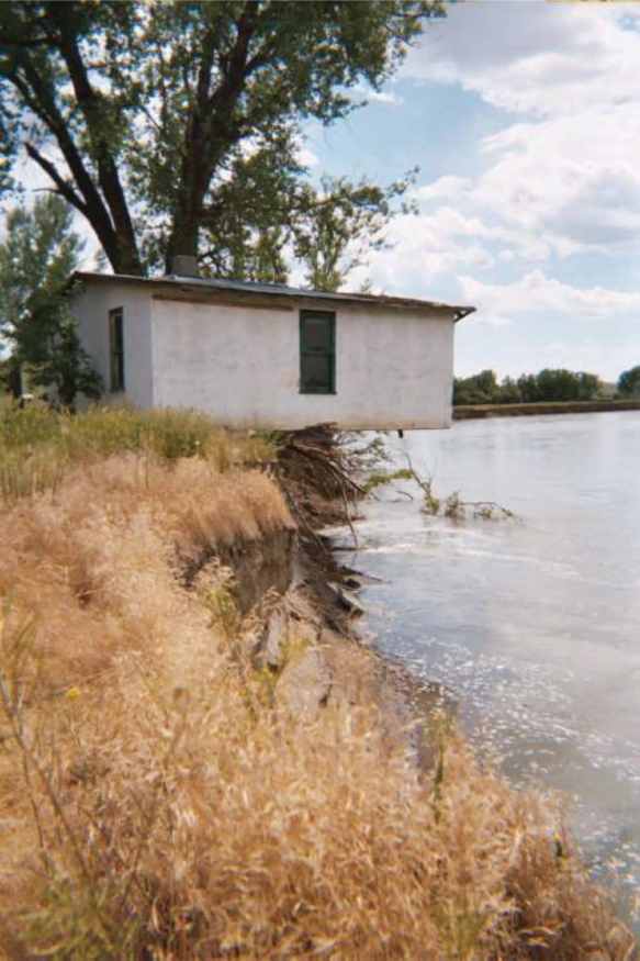
Figure 5.4 The river under the house
Landowners hoping to stabilize their riverbanks must now secure state and federal permits, and they must use only approved materials, such as large granite boulders. The placement of these boulders must also follow strict guidelines to avoid “pushing” the erosion problem to a neighbor’s property. Landowners, thus, typically must hire an engineer to design their projects, and they sometimes invest hundreds of thousands of dollars to stabilize only a few hundred feet of riverbank (Gilbertz, Horton, and Hall 2006). As one landowner described his frustrations about erosion of his property, it is clear he feels abused by the river, the rules, and the economics of his situation:
I never know where my property line is at … It’s a wild and uncontrolled river, and the river takes a little every year. In real high-water years, its more aggressive. It takes fertile soil real fast … It has worked its way into my meadows… and I’ve lost productive ground … If I had substantial resources there might have been things that could have been done … [but] the scale is overwhelming … To restructure an old jetty and put in the riprap, it was three- to five-times the cost of the land … I didn’t have enough money. What could have I done? What should have I done? I’m not whining, I’m resigned … I’ve resigned myself to this in sadness … Free-flowing at whose cost? The people who want the river to run, where it wants to run, don’t pay for it. I should be getting an award from the free-flowing folks because I’ve contributed a half-million in the form of lost land. (Agricultural Landowner near Columbus 2006)
Even those not personally affected can see the landowners’ problems. An owner of a raft rental business, described the dilemmas this way:
The thing about the Yellowstone is, it’s such a meandering, naturally flowing river. It seeks all these little braids, and channels, and so on. So, it seems to work well over time. I know that people that have riverfront property get [nervous] when they start to get high water or floods and the natural erosion process takes place. And, whether it’s cultivated land or not, people start putting in riprap to protect against erosion. [It] will actually change the water, away from just coming in and cutting into the bank … But, if you do that over on one side of the river, maybe it just shoots it over and starts to do the same thing over on the other side of the river … I’m not sure, but my suspicion is that when you start to mess around with it too much, then it’s going to eliminate or degrade some of that natural structure and natural habitat. (Rafting Outfitter near Gardiner 2006)
As illustrated by the Physical Features Inventory of the Yellowstone River, protective projects, alterations meant to prevent river channel migration, are numerous throughout the valley (Explore Yellowstone n.d.). For example, much of the riverbank around Billings, a city of over 100,000 people, has been armored, and side-channels have been blocked. In one 6-mile stretch of the river (Reach B2), approximately 21,700 feet, or 4.1 miles, of bank armor has been put in place, and over 6,500 feet of side channels have been blocked (Reach Narrative B2 2015, 8). Nearby (Reach B3), another nearly 14,000 feet of side channels are blocked (Reach Narrative B3 2015, 12). In these areas, riparian functions have been essentially eliminated. Even where there are few structures and where development seems far less extensive than in the more urban areas, numerous bank stabilization and side-channel projects are completed each year. These projects are generally intended to protect property from flooding and erosion.
Another impact to riparian areas is caused when landowners shift the land to agricultural purposes. Known as land-use conversions, these changes can all rather wholly eliminate the riparian functions. In the lower valley, areas that were once densely populated with cottonwood forests are now used as cultivated fields (Reach D8). The spatial extent of these types of conversions, and the resulting decline in nesting habitats, have been calculated as a lost riparian function (CEA 2015).
Other impacts to channel migration and riparian areas are the result of flood control projects. The towns of Forsyth (Reach C10), Miles City (Reaches C16 and C17), and Glendive (Reaches D5 and D6) are all protected by levees. Unfortunately, in some cases the levees are no longer certified by the COE. Residents in these towns should carry federal flood insurance, but many of them do not. They believe the levees, in place since their grandparents lived in these towns, will not fail (Gilbertz, Emerson, and Hall 2020). Although the longevity of the levees is arguable, all of the levees affect riparian function. They tend to constrict the river into one channel by cutting off side channels and they eliminate channel migration processes that might occur if flooding were allowed.
Despite extensive costs and complex engineering, efforts to protect properties are sometimes in vain. In 1996 and 1997, high waters washed away many of the protections for Livingston residents whose homes were built on an island in the river (Reach PC14). Several homes were lost entirely to flooding that year, and others were all but lost (Figure 5.5). In the aftermath, dozens of landowners proposed armoring their properties. Today, where the river flows on the Livingston side of the island, various stabilization methods keep the river in a prescribed channel, and the river is constrained on both riverbanks (Reach PC14). More recently, flooding in 2018 threatened many of the valley’s communities. It was feared that in Huntley—a town of just over 400 residents just east of Billings (Reach B5)—400 structures would be affected. Had the waters crested as expected, nearly the entire town would have been flooded. The flood threats are very real, in some years more immediately than in others.
Examples from the Missouri River help illustrate other issues with spring floods. Cities downstream of its confluence with the Mississippi River, such as St. Louis and Memphis, are often in harm’s way when spring runoff combines with spring rainstorms. Every year, the COE is faced with deciding where to direct flood waters so that damages will be minimized. Typically, a levy will be opened upriver from an urban area to disperse the water across the broader (historical) floodplain and reduce the potential for loss of property and life in the city. Not only are downstream areas then protected from immediate inundation, the water loses velocity, and its destructive power is greatly diminished. Less densely occupied areas are more likely to be sacrificed than urban areas. Of course, those residents whose properties are intentionally flooded are extremely upset; however, it makes good economic and humanitarian sense to direct flood waters to areas with the least development and the fewest numbers of people. In the future, similar calculations may be necessary in the Yellowstone River Valley.
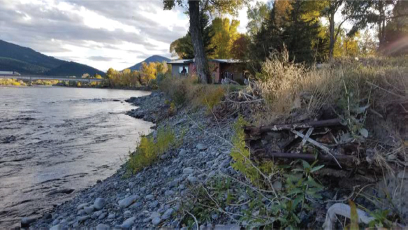
Figure 5.5 House on island after the floods took owner’s yard
Predictably, humans living near the river hope to stall flooding, erosion, and avulsion on their properties (Figure 5.6). Levies and bank armoring can be argued as building the resilience of the (human) community. However, these protections test the limits of our river system’s resilience. We are drawn to rivers for all that they provide, but subsequent actions designed to protect investments in riverfront property endanger, ironically, the river system itself. Remember, it is reasonable to assume that had we stayed mostly out of the floodplains, channel migration zones, and riparian areas, both the Pallid Sturgeon and the cottonwood forests, as well as countless other animal and plant species, would be much better off.
Figure 5.6 Retirement home by the Yellowstone River
It is, perhaps, time to put less effort into protecting property and to put more consideration into protecting channel migration, riparian areas, and floodplains. At the very least, human interventions should be evaluated in terms of the unintended side effects and legacies that may cause new problems that ripple through river ecosystems (Hohensinner, Hauer, and Muhar 2018).
Final Thoughts About Resilience and Sustainability
Taken individually, our practices and actions seem quite reasonable. Yet, we know that we are slowly polluting our waters, and we know that with each successive project on the riverbanks we compromise the health of the riparian areas. So, although it is true that no one project or practice in a riparian area will wholly harm the river or its riparian health, it is also true that, cumulatively, flood control and bank stabilization efforts can significantly impair riparian processes and functions (CEA 2015). In the beginning pages of this book, we noted that underlying the pursuit of sustainability is the implicit charge to examine our practices willingly and critically. A river’s resilience—its ability to withstand assaults—is not unlimited, and the Yellowstone River is no exception. Knowing that each project chips away at the river system’s ability to function, we also know riparian health is at risk and that our ecosystem services are slipping away. In some places on the river, it is difficult to even pretend there is much “health” left. To what degree should we limit building in the flood zones, riparian areas, or channel migration zones?
If we do not act carefully, our economies, environment, and communities become much less sustainable and less resilient to foreseeable and unforeseeable adversities. The examples presented in this chapter—of water rights and river functions—make us aware of the profound complications involved in attending to the valley’s long-term economic, environmental, and social well-being. Water is vital to every aspect of life in the valley (Figure 5.7). Our industries compete for supplies, the health of our environment depends on how well we manage our water resources, and our notions of fairness are complicated by a host of water laws that define access to opportunities. Even in 2006, local river enthusiasts were voicing caution:
There’s a direct tie between how well we manage all these activities and the health of the river. And that really is the problem that we face with the Yellowstone. Because none of these activities are benign in terms of the health of the river. (River Access Activist from Billings 2006)
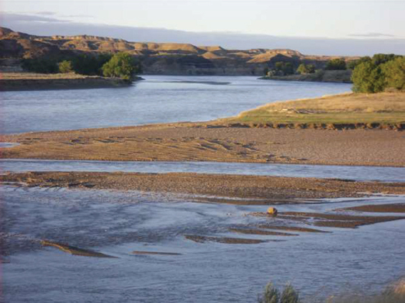
Figure 5.7 The Yellowstone River near Terry
It is tempting to ask about thresholds, demarcations that would alert us to “go no further or risk ruin.” We might think that we could better manage for sustainability and resilience if only we knew exactly how much we will have and how much we dare to take from the environment or from one another. However, as seen in this chapter, it is impossible to anticipate the totality of factors that would precisely define these thresholds. Worse, a history of human behavior has shown that identifying hypothesized thresholds effectively permits us to approach those limits, not knowing whether or not we miscalculated and have already surpassed a system’s limits. It would be wiser to evaluate the direction in which we are headed and to make a course correction, if our path appears to lead us toward the ruin of our resources. Are we smart enough to change course? Do we have the resolve?
Regarding water rights:
1. Should we prioritize beneficial uses in Montana?
2. Should agriculture expect to continue with “business as usual” while fishing guides are asked to suspend their income-generating activities?
3. Should industries be allowed to permanently dispose of our water resources?
4. Will intense and/or prolonged droughts force us to consider new water-use rules?
5. Will we assure every resident of the valley access to good quality drinking water?
6. Is it fair to change the rules regarding water allocations?
Regarding the functions of riparian areas, we should ask:
1. Is riparian health wholly at risk in the Yellowstone River Valley?
2. Are we compromising the ecosystem services provided to us by the river so much that even our immediate needs are in jeopardy?
Given all that we have examined, we see that sustainability’s central question is helpful, but not especially directive in local settings. Are we ready to ask better questions regarding the sustainability of the Yellowstone River Valley:
1. Is the Yellowstone River Valley moving toward or away from a resilient economy?
2. Will future generations in the valley inherit a more or less resilient and healthy natural environment?
3. Are communities in the valley moving toward improving resilience in terms of social fairness?
4. Are the communities in the valley moving toward overall resilience in terms of the complexities of the valley?
5. How might business models help agriculture, tourism, and the oil and gas industries incorporate complex sustainability goals into their operations?
6. In what ways are the residents’ comments, from the various chapters, useful to sustainability advocates hoping to improve the resilience of their communities?
Easy Access Resources
Estimated Water Use in Montana in 2000: https://pubs.usgs.gov/sir/2004/5223/pdf/sir2004_5223.pdf
“How Are Instream Flows Protected?” Fact Sheet: https://static1.squarespace.com/static/5498382ce4b015fce7f847a2/t/57c7244c9f7456b915e34ccf/1472668777218/WaterFactSheets_ALL.pdf
Interactive Map of the Yellowstone River: http://montana.maps.arcgis.com/apps/webappviewer/index.html?id=3fc5b219f4494ebab2477e93a5bbecca
Impacts of Stabilization on the Yellowstone River-Reach B3: http://ftp.geoinfo.msl.mt.gov/Documents/Projects/Yellowstone_River_Clearinghouse/Yellowstone_Reach_Narratives_2015.pdf
“Montana Water Rights Protection Act” U.S. Senate Bill. www.congress.gov/bill/116th-congress/senate-bill/3019/text
Nonpoint Source Pollution: Agriculture: www.epa.gov/nps/nonpoint-source-agriculture
Tribal Water Rights, Montana’s Summary: https://mtdnrc.maps.arcgis.com/apps/MapJournal/index.html?appid=63c5e165d5e34681a3cc3b7a615ab442
Reserved Water Rights for Indian Reservations, U.S. Department of Justice Summary: www.justice.gov/enrd/federal-reserved-water-rights-and-state-law-claims
Riparian Systems: www.nrcs.usda.gov/Internet/FSE_DOCUMENTS/nrcs143_010137.pdf
Water as a Human Right, United Nations: www.unwater.org/publications/eliminating-discrimination-inequalities-access-water-sanitation/