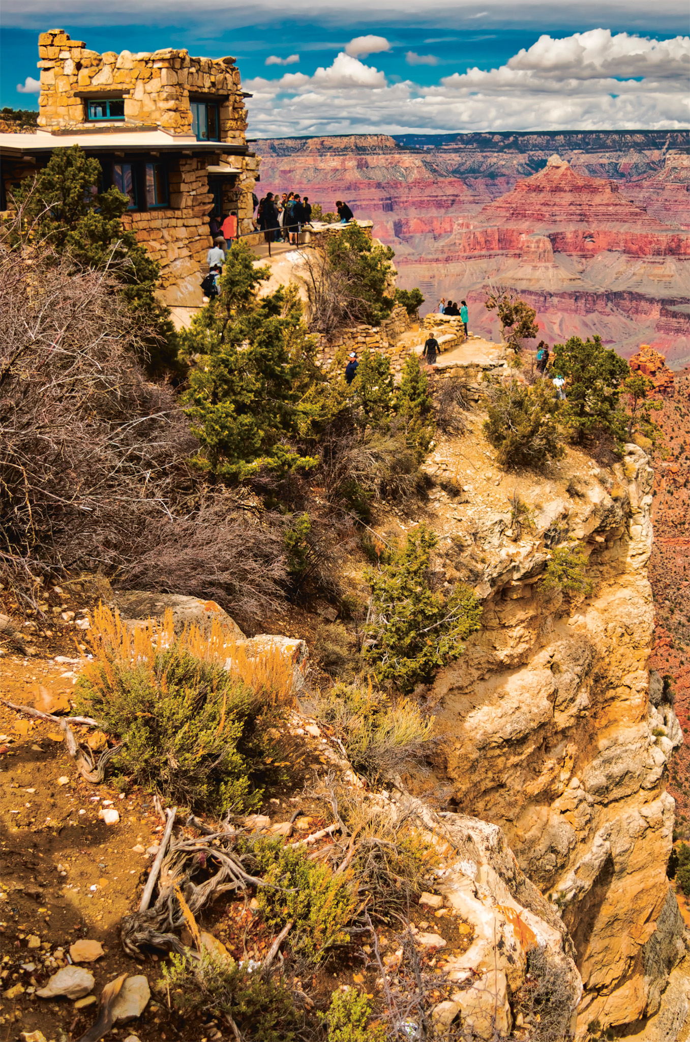
One of the world’s great natural wonders, the Grand Canyon offers awe-inspiring beauty on a vast scale and is an instantly recognizable symbol of the Southwest. Its beauty is revealed in the ever-shifting patterns of light and shadow and the colors of the rock, bleached white at midday, but bathed in red and ocher at sunset.
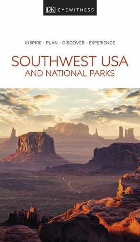
t A ranger leading tourists on a mule ride along the narrow trails of the South Rim
Experience Grand Canyon and Northern Arizona

t Rock formations of the Grand Canyon with the Colorado River at sunset
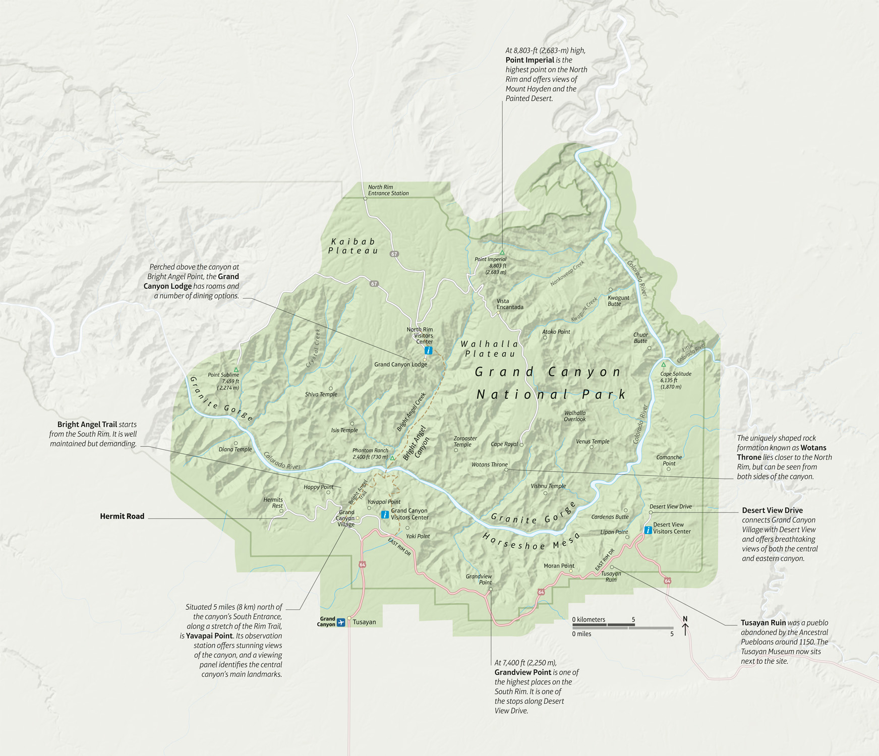
An iconic World Heritage Site, the Grand Canyon National Park covers 1,904 sq miles (4,930 sq km) and is made up of the canyon itself, which starts where the Paria river empties into the Colorado, and surrounding lands that stretch from Lees Ferry to Lake Mead. The area gained national park status in 1919. The park has two main entrances, on the North and South rims of the canyon. The southern section of the park receives the most visitors and can become very congested during the summer season. Visitors can park in nearby Tusayan and take a free shuttle bus to the South Rim.
The canyon is 277 miles (446 km) long, an average of 10 miles (16 km) wide, and around 5,000 ft (1,500 m) deep. It was formed over a period of six million years by the Colorado River, whose fast-flowing waters sliced their way through the Colorado Plateau, which includes the gorge and most of northern Arizona and the Four Corners region. The plateau’s geological vagaries have defined the river’s twisted course and exposed vast cliffs and pinnacles that are ringed by rocks of different color, variegated hues of limestone, sandstone, and shale. The magnificent rock formations with towers, cliffs, steep walls, and buttes recede as far as the eye can see, their bands of rock varying in shade, as light changes through the day. The park’s main roads, Hermit Road and Desert’s View Drive, start at Grand Canyon Village and encompass a selection of the choicest views of the gorge. Walking trails along the North and South rims offer staggering views, but to experience the canyon at its most fascinating, explore the more challenging trails that lead to the canyon floor.
Did You Know?
The temperature at Grand Canyon varies by about 20° F (11° C) from top to bottom.
Hermit Road
Running from Grand Canyon Village west to Hermits Rest, this 7-mile (11-km) road follows the canyon rim and provides some of the best canyon views from anywhere. It is closed to all private vehicles from March through November, when a free shuttle bus takes visitors between eight stunning over-looks along the way, including Trailview Overlook, Maricopa Point, and Hopi Point. You can also walk between the view-points on the Rim Trail, and catch the shuttle at any time. Hermit Road is also a great cycle route.

GREAT VIEW
Hopi Point
Projecting far into the canyon, the tip of Hopi Point offers one of the best spots for viewing sunsets along Hermit Road. As the sun sets, it highlights the can-yon’s many beautiful sculpted peaks.
The South Rim
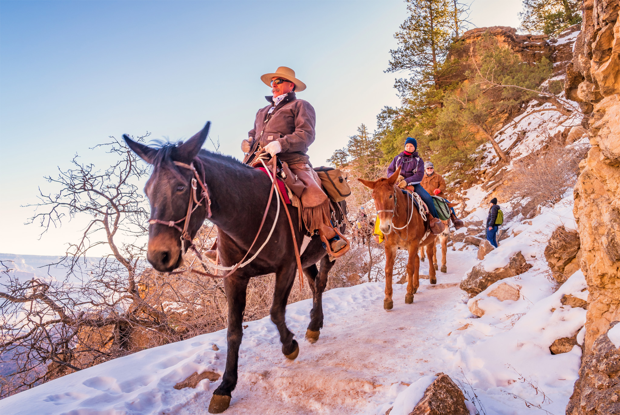
t The Lookout Studio, also known as the Lookout, on the South Rim
Most of the Grand Canyon’s 6.3 million annual visitors come to the South Rim, since, unlike the North Rim, it is open year-round and is easily accessible along Highway 180/64 from Flagstaff or Williams. Hermit Road is closed to private vehicles from March to November, but there are free shuttle buses. The longer Desert View Drive (Highway 64) is open all year, winter snows permitting, and leads 60 miles (97 km) in the opposite direction to Cameron. After winding for 12 miles (20 km) from Grand Canyon Village it reaches Grandview Point, where the Spaniards may have had their first glimpse of the canyon in 1540. Ten miles (16 km) farther on lie the pueblo remains of Tusayan Ruin, where a small museum has exhibits on the Ancestral Puebloans. After a few miles, the road leads to Desert View with a fanciful Watchtower, its upper floor decorated with early 20th-century Hopi murals. It was designed by ex-schoolteacher and trained architect Mary E.J. Colter, who drew on Native American and Hispanic styles and is responsible for many of the historic structures that grace the South Rim, including the 1914 Lookout Studio and Hermits Rest, and the rustic 1922 Phantom Ranch on the canyon floor.
Did You Know?
Kolb Studio, the former home of the Kolb brothers, exhibits their stunning photos of the Grand Canyon.
The North Rim
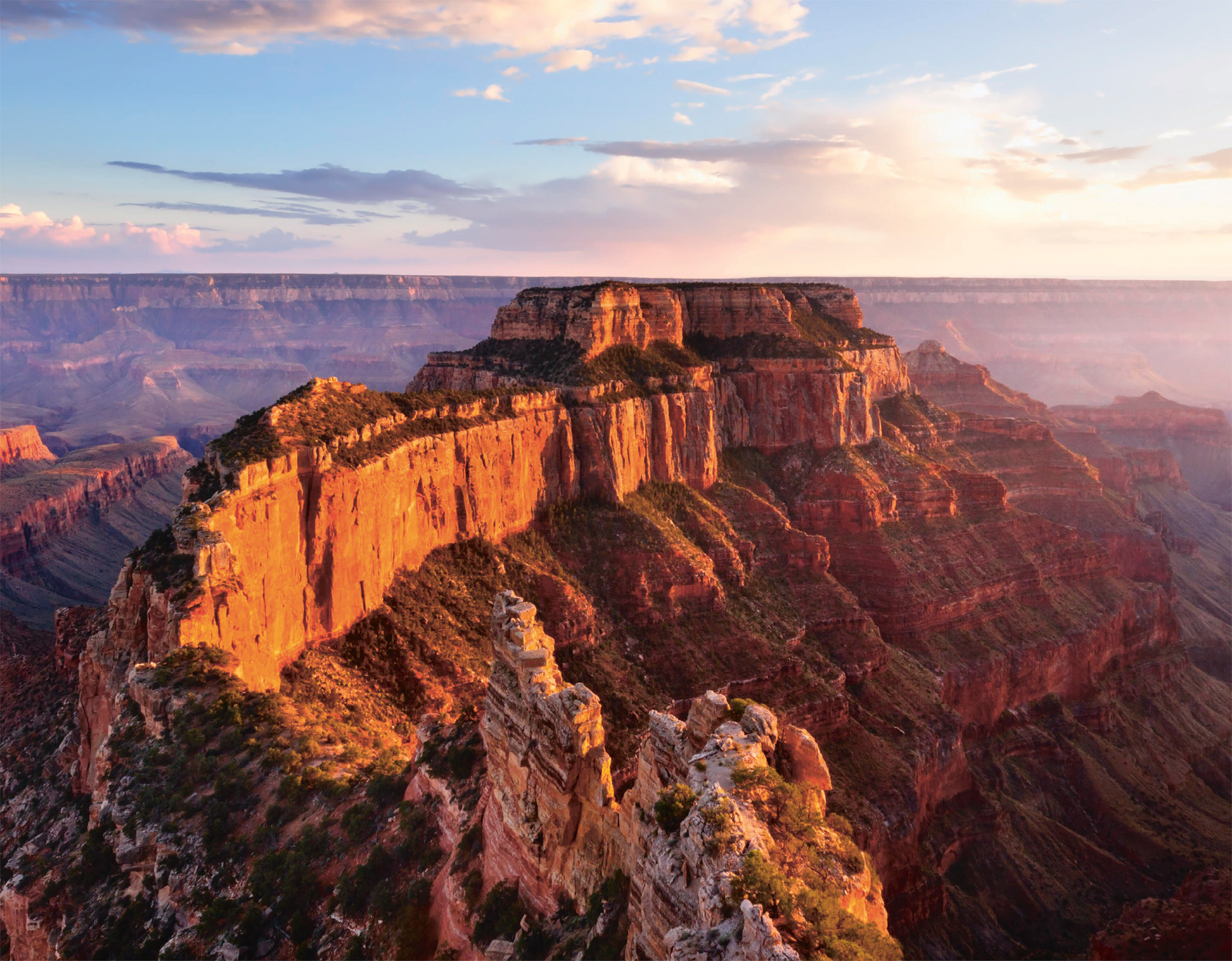
t Wotans Throne, seen from Cape Royal on the North Rim
Sited at about 8,000 ft (2,400 m), the North Rim is higher, cooler, and greener than the South Rim, with dense forests of ponderosa pine, aspen, and Douglas fir. Visitors are likely to spot wildlife, such as mule deer, Kaibab squirrel, and wild turkey. The North Rim is reached via Highway 67, off Highway 89A, ending at Grand Canyon Lodge, where there are a campground, gas staion, restaurant, and a general store. The North Rim is twice as far from the river as the South Rim, and the canyon really stretches out from the over-looks giving a sense of its massive width. There are about 30 miles (48 km) of scenic roads, as well as hiking trails to high viewpoints or down to the canyon floor (of particular note is the North Kaibab Trail that links to the South Rim’s Bright Angel Trail.) The picturesque Cape Royal Drive starts north of Grand Canyon Lodge and travels 23 miles (37 km) to Cape Royal on the Walhalla Plateau. From here, several famous buttes and peaks can be seen, including Wotans Throne and Vishnu Temple. There are also several short, easy walking trails around Cape Royal. A 3-mile (5-km) detour leads to Point Imperial, the highest point on the canyon rim, while along the way the Vista Encantada has delightful views and picnic tables overlooking the gorge.
EXPERIENCE Grand Canyon and Northern Arizona
|
Stay El Tovar With a perfect location right on the canyon rim, this luxurious landmark lodge, built in 1905, incorporates natural stone and Douglas fir. The restaurant serves excellent Southwestern cuisine. ⌂ 1 El Tovar Rd ∑ grandcanyonlodges.com \ Bright Angel Lodge The famed architect Mary Elizabeth Jane Colter designed this rustic, log-and-stone lodge and cabins in 1935. Accommodations range from basic lodge rooms to historic cabins with fireplace and TV. ⌂ 9 North Village Loop Dr ∑ grandcanyonlodges.com \ |
The Bright Angel Trail
The most popular of all Grand Canyon hiking trails, the Bright Angel trail begins near the Kolb Studio at the western end of Grand Canyon Village on the South Rim. It then continues via a series of switchbacks down the side of the canyon for 9 miles (14 km). The trail crosses the river over a suspension bridge, ending a little further on at Phantom Ranch. Do not attempt to walk all the way to the river and back in one day. Temperatures at the bottom of the canyon can reach 110° F (43° C) or higher during the summer. It is essential for day hikers to carry plenty of water and salty snacks in summer.
Experience Grand Canyon and Northern Arizona
California Condors

The California Condor is America’s largest bird, with a wingspan of over 9 ft (2.7 m). The species was on the edge of extinction in the 1980s, when the last 22 condors were captured for breeding in captivity. In 1996 the first captive-bred birds were released in Northern Arizona. Today, over 80 condors fly the skies over Northern Arizona. They are frequent visitors to the South Rim, though visitors should not approach or feed them.
Exploring Grand Canyon National Park

n Locator Map
The park’s main roads, Hermit Road and Desert View Drive, both accessible from the south entrance, overlook the canyon. Stop at the excellent visitor center at the south entrance, where you can pick up detailed maps of drive routes and hiking trails, see a video-enabled relief map, study exhibits of artifacts, and rent a bike or book a guided bike ride. Grand Canyon Village is located on the South Rim and offers a wide range of hotels, restaurants, and stores. It is also the starting point for most of the mule trips through the canyon and the terminus for the vintage Grand Canyon Railway from Williams. Visitors can also enter the park from the north, although this route (Highway 67) is closed during winter. The Bright Angel Trail on the South Rim and the North Kaibab Trail on the North Rim descend to the canyon floor and are tough hikes involving an overnight stop.
Experience Grand Canyon and Northern Arizona
n Double-tap image to read the labels
The Geology of the Grand Canyon
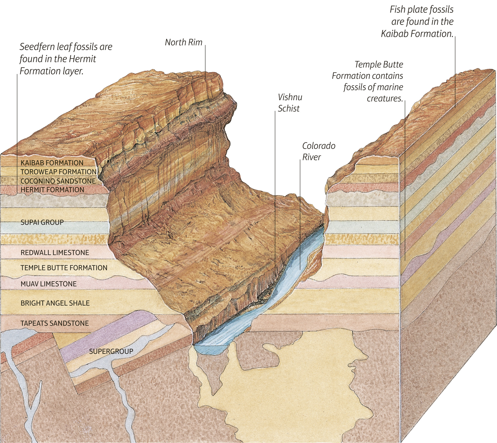
t Geologic rock layers of the Grand Canyon
The Grand Canyon’s multicolored layers of rock provide the best record of the Earth’s formation anywhere in the world. Each stratum of rock reveals a different period in the Earth’s geologic history beginning with the earliest, the Precambrian era, which covers geologic time up to 570 million years ago. Almost two billion years of history have been recorded in the canyon, although the most dramatic changes took place relatively recently, five to six million years ago, when the Colorado River began to carve its path through the canyon walls. The sloping nature of the Kaibab Plateau has led to increased erosion in some parts of the canyon.
The Asymmetrical Canyon

t The spectacular cliffs and pinnacles of the Grand Canyon’s beautiful South Rim
The North Rim of Grand Canyon is more eroded than the South Rim. The entire Kaibab Plateau slopes to the south, so rain falling at the North Rim flows toward the canyon and over the rim, creating deep side canyons and a wide space between the rim and the river.
How the Canyon was Formed
While the Colorado River accounts for the canyon’s depth, its width and formations are the work of even greater forces. Wind rushing through the canyon erodes the limestone and sandstone a few grains at a time. Rain pouring over the canyon rim cuts deep side canyons through the softer rock. Perhaps the greatest canyon-building force is ice. Water from rain and snowmelt works into cracks in the rock. When frozen, it expands, forcing the rock away from the canyon walls. The layers vary in hardness. Soft layers erode quickly into sloped faces. Harder rock resists erosion, leaving sheer vertical faces.
The Colorado River
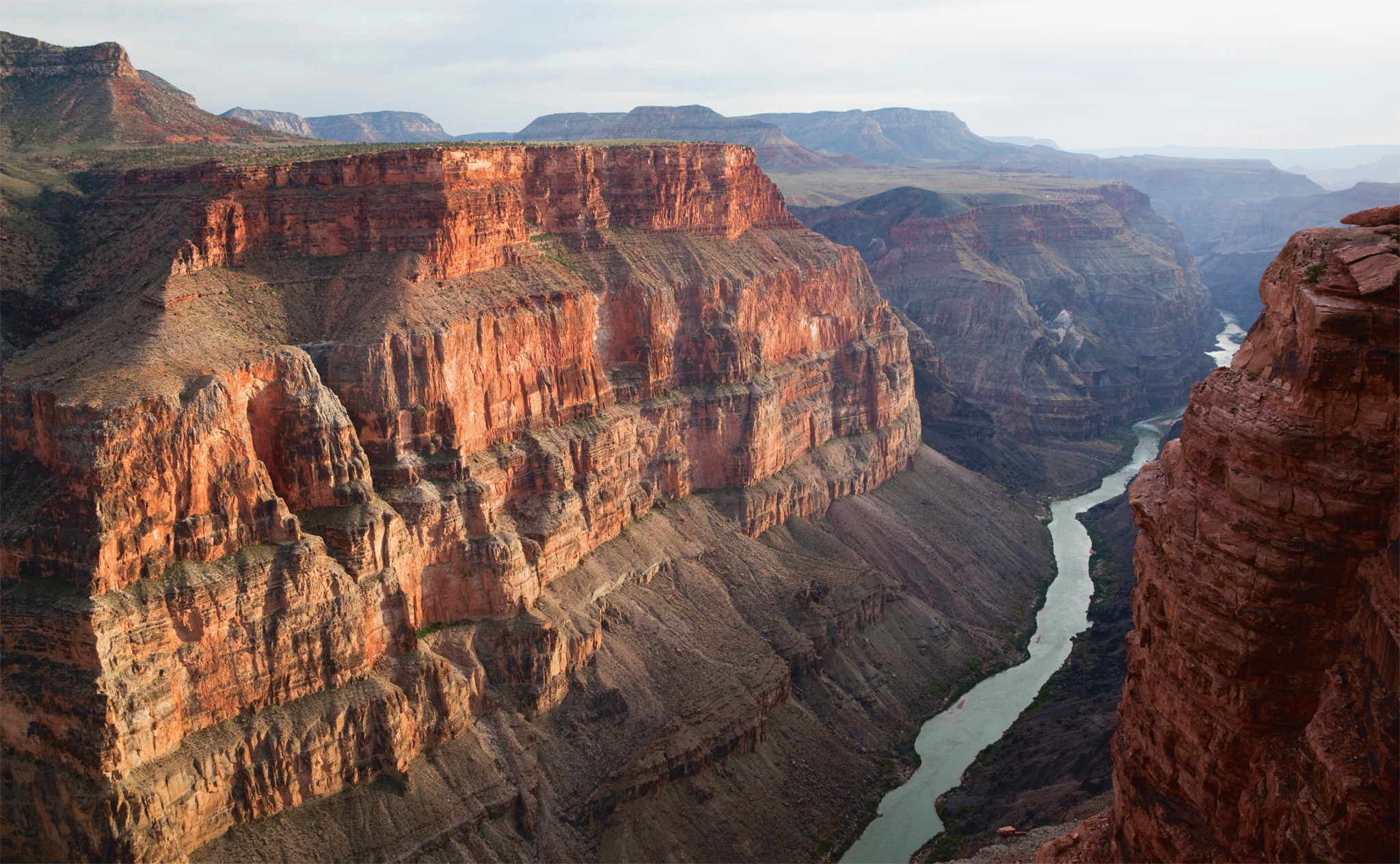
t The North Rim, with the Colorado River running through the canyon
About five million years ago the Colorado River changed its course. According to one theory, it was encompassed by another, smaller river that flowed through the Kaibab Plateau. The force of the combined waters carved out the deep Grand Canyon. The South Rim of the canyon lies closer to the Colorado River than to the North Rim.
Did You Know?
The three main types of sedimentary rocks at the Grand Canyon are sandstone, shale, and limestone.
Experience Grand Canyon and Northern Arizona
Record of Life

The fossils found in each layer tell the story of the development of life on Earth. One of the oldest layers in the canyon, the Vishnu Schist, was formed in the Proterozoic era, when the first bacteria and algae were just emerging. Many of the layers were created by billions of small marine creatures, whose hard shells eventually built up into thick layers of limestone.