
Chapter 5
Zeroing in
Overhead imagery, infrastructure ruins, and datalands in Afghanistan and Iraq
To “zero in” means to aim directly at a target, to direct one’s attention to; focus on; concentrate on; to converge on; or close in on.1 Zeroing in is an apt metaphor for the way citizen-viewers are positioned in relation to world events since they increasingly view them from the perspectives of militarized aerial and orbital machines. Such a claim is, of course, not new, and scholars such as Paul Virilio, Kevin Robins, and Jody Berland among others have explored how such aerial and orbital perspectives structure particular ways of engaging with the world.2 What is new, however, is the frequency with which such overhead images now circulate in our global media culture. Once relegated to the TV weather report, such images have become commonplace in news media, and form the backbone of world browsers like Google Earth. This proliferation is related to a combination of factors from the commercialization of the remote sensing industry to the gradual transformation of the Internet into a locationbased web 3.0.
With its increased accessibility, the overhead image has taken on heightened significance and functions in our media culture in a variety of ways. First, and perhaps most obviously, it has become the establishing or master shot for many mediated news events and, like the world map before it, is used to orient the viewer/user in a global/local space of coverage. Second, the overhead image activates a desire for what it is not – a close up – and triggers a demand for more local or embodied views in contrast to its remote and abstract perspectives. This desire is typically gratified through technique of the digital zoom. Third, the overhead image has been used as a visual gimmick by TV news producers who are desperate to attract eyeballs in the competitive multichannel environment. One of the most glaring attempts to use satellite images to reinvent news esthetics can be found in CNN’s “magic wall.”
Finally, and most germane to this essay, the overhead image, I want to suggest, serves as a symptom of practices of power that Rey Chow delineates in her recent book The Age of the World Target. Building on the work of Heidegger and Virilio, Chow suggests,
… we may say that in the age of bombing, the world has also been transformed into – is essentially conceived and grasped as – a target. To conceive of the world as a target is to conceive of it as an object to be destroyed.3
Rather than simply correlate the power to see with the power to destroy, Chow moves subtly from a discussion of a Hiroshima mushroom cloud photo, which she sees as an iconic moment for imagining the world as target, and proceeds to describe and critique the emergence of “area studies” in academia, which developed after World War II in relation to US foreign policy, as a way of organizing and targeting the world for Western knowledge production. Chow defines the age of the world target as a time in which “… war and peace are coexisting, collaborative functions in the continuum of a virtualized world” and reminds us that, “… only the privileged nations of the world can afford to wage war and preach peace at one in the same time.”4
Building on Chow’s argument, I want to suggest that the overhead image is a particularly useful site for thinking through the idea of the world as a target, not only because of its strategic vantage point, but also because of its particular relation to knowledge practices and the materiality of communication. Technically speaking, the overhead image refers to image data that has been acquired by instruments onboard aircraft or satellites, downlinked to earth stations, rendered by computer software, and, in some cases, composited for the purpose of representing, viewing, and analyzing particular sites or activities on earth. The production of the overhead image is made possible by a vast and largely invisible communication infrastructure, which, I would argue, undergirds the capacity to imagine the world as a target. Aircraft, satellites, and the imagery they generate, are all used to guide missiles, coordinate movement, and reorganize capital. Their “views from above” can be useful platforms for thinking about the production of knowledge and the materiality of communication because they draw attention to such issues as the weaponization and commercialization of frames and perspectives, the transformation of sovereign territories into navigable digital domains, and the accumulation and circulation of new forms of intellectual property.
Further, the overhead image provides an opportunity to think about knowledge practices and the materiality of communication in ways that do not rely exclusively upon the visibility of bodies or frames as “purely representational.” As I have argued elsewhere, satellite images can be used to bring (infra)structural processes and matters to the fore by intimating or revealing parts of systems or processes that are simply too vast for the frames, conventions, and capacities of modern media.5 By using such views to zero in on the “infrastructural” we begin to notice that the materiality of communication is often designed to be invisible, whether submerged underground or underwater, blended in with the built environment, or situated beyond human perception. Perhaps ironically, then, the overhead image ultimately challenges us to recognize the limits of a “purely representational” frame.
The notion of the world target, the use of overhead imagery, and the question of infrastructure are all highly relevant to the US wars in Afghanistan and Iraq. In this essay, I use the term “zeroing in” to conceptualize a series of knowledge practices and material conditions that have taken shape in relation to overhead imagery of Afghanistan and Iraq. My discussion moves from an analysis of declassified US overhead imagery of bombed communication infrastructure in Afghanistan and Iraq to a consideration of the “shutter control rule,” designed to limit access to high-resolution satellite imagery during times of war, and onto a discussion of the emergence of Google Earth and some of the controversies surrounding its use. In the process, I consider how overhead images simultaneously represent the world, or parts of it, as sites of scrutiny, destruction, and extraction. In other words, one overhead image may reveal a site to monitor, to destroy, and/or to develop (or redevelop). As this view figures the earth’s surface as a target of observation, conquest, and development, it is commandeered in flexible economies of visual, military and corporate power, and in efforts to censor information and regulate interpretation. The destruction of communication infrastructure in Afghanistan and Iraq has occurred contemporaneously with the expansion of US satellite and aerial reconnaissance systems and global media platforms such as Google Earth, both of which have been used not only to document warfare in Afghanistan and Iraq but also to digitize and corporatize these countries’ territories and model their futures.
Clear-cutting communication infrastructure
It is somewhat of a paradox that the first act of war when overthrowing authoritarian regimes with the intent to “democratize” them is the bombing of their communication infrastructures, especially given that parts of these systems have often been built with the aid, whether direct or indirect, of the US government or its allies. Nevertheless, the eradication of communication infrastructure has become a classic technique of modern warfare that has built within it the potential for the US government and multinational corporations to profit from the reconstruction of these systems during postwar periods.6 US corporations have invested in the telecommunication and broadcast sectors of both Afghanistan and Iraq, annexing these territories into a US dominated global media economy. Such investments began even before the war started. As Michael Barker indicates,
In Iraq the allocation of media reconstruction grants started early, and more than a week before the US officially started bombing Iraq, the Pentagon gave a $15 million contract to Science Applications International Corporation to revive Iraq’s national broadcasting system and convert it into a Coalitional Provisional Authority administered Iraqi Media Network.7
As bombs fell from the skies to destroy communication systems in Afghanistan and Iraq, leaflets promoting the promise of new TV and radio stations fluttered to the ground and civilians were targeted with information instructing them how and where to get their broadcast news from now on and directing them to coalition-run radio and television frequencies. One even addressed potential terrorists and featured a photo of a spy satellite reminding them, “We can see everything. Do not use nuclear, biological, or chemical weapons.” Practices of leafleting and aircraft broadcasting were used to gradually transition viewers from systems of communication controlled by old regimes to ad hoc systems controlled by the US-led coalition. In addition to attacking the communication infrastructure and resources of the Taliban and Saddam Hussein, the United States declared all satellite uplinks in war zones military targets, and consequently attacked the stations of transnational media corporations (such as Al Jazeera and Abu Dhabi) as well as foreign journalists working at the Palestine Hotel in Baghdad.
After the attacks on the communication facilities of the Taliban and Saddam Hussein regimes, the Pentagon released declassified overhead images of destroyed communication facilities to confirm the hits. These images may not have the same kind of symbolic power as the toppling of Hussein’s statue, but they serve a similar discursive function in that they allow the viewer to zero in on the damage done to old regimes. Some of these images appeared in military press conference briefings and television news reports. They also were archived in the Image Intelligence gallery of the Federation of American Scientists website and the GlobalSecurity.org website.8 One dated October 10, 2001 shows a radio station in an unidentified location in Afghanistan. It features a compound inscribed with two yellow arrows pointing to charred areas on top of separate buildings. A second satellite image features one yellow arrow identifying a hit on a Taliban communications facility in Heart dated October 15. The arrow points to a dust bowl where nothing is left. Finally, another documents a strike on a Kabul RADCOM station dated October 22 and two yellow arrows identify the locations of facilities that appear to no longer exist.9
Similar satellite images of attacks on communication infrastructure in Iraq exist. Some of them were included in a National Security Archive report entitled “Eye on Saddam” published on April 30, 2003. The satellite images are not dated but presumably the data was acquired between March 20, 2003–April 30, 2003. One of the frames includes pre- and post-strike images with five blue arrows in the post-strike view indicating areas that had been hit (Figure 5.1). Several large dish receivers are visible as well as nearby buildings and a transmission tower. Neither the precise location of the site nor the date of the strike is specified. Pre- and post-strike satellite images of the regime command and control facility at Saddam International Airport were also released. The post-strike view features 26 blue arrows indicating different areas throughout the compound that have been hit (Figure 5.2).10 Another post-strike image of a Command and Control Facility in Tikrit with four arrows pointing to sites in three different buildings that had been bombed.
Figure 5.1 US military intelligence image featuring pre- and post-strike views of an attack on a Television and Communications Facility in Iraq.
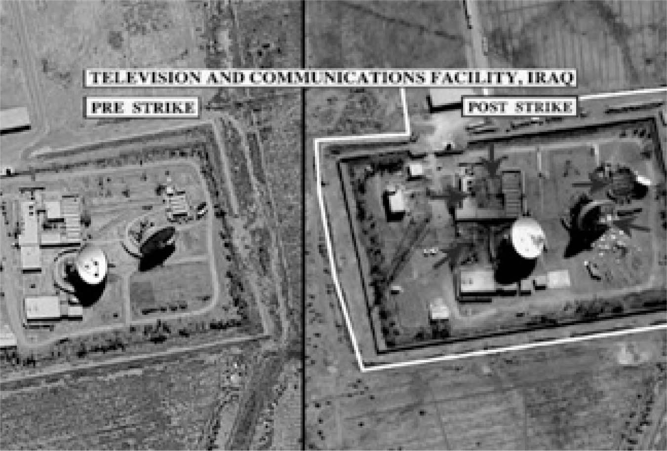
Source: These materials are reproduced from www.nsarchive.org with the permission of the National Security Archive.
Figure 5.2 US military intelligence image featuring post-strike view of an attack on Saddam International Airport in Iraq.
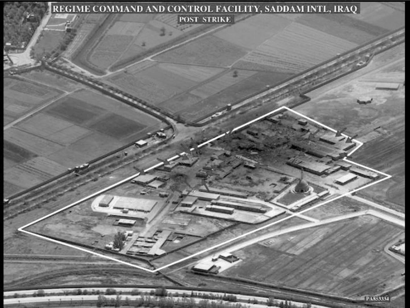
Source: These materials are reproduced from www.nsarchive.org with the permission of the National Security Archive.
While there is a long history of photo intelligence interpretation that involves training experts to read and interpret overhead images, such practices and the authority associated with them have been challenged as these images have circulated more widely in mass media culture.11 These overhead images of Afghanistan and Iraq not only position the citizen-viewer quite literally as reading the earth’s surface as a target but also they position others’ communications networks as sites to be destroyed. Each of the images is inscribed with arrows that point to sites that have been hit. Here the act of guiding missiles to targets is transposed with guiding acts of interpretation. The images embed arrows to “direct the look” and thus their public release not only circulates information but also is designed to regulate interpretation. This attempt to control interpretation has the effect of restricting the interrogative mode, which, I have argued elsewhere, could be used productively in relation to the abstraction and remoteness of satellite imagery, to trigger further inquiry about the status of the image, the satellite that acquired the image data and the specificity of what lies below.12 The arrows are positioned to allow an efficient or quick “read” and to lead the viewer to make rapid-fire assumptions about what the image represents. Such practices resonate with Nicholas Mirzoeff’s discussion of the “weaponized image” – an image developed as a “carefully and precisely targeted tool” that is “designed in itself to do psychic harm.”13 Mirzoeff’s complaint was that during the Iraq war, “So many images were being created that there was never time to pause and discuss any one in particular.”14 Such declassified images should always be examined with close scrutiny and skepticism, especially given the ways they have historically been used by US officials for political gain.
Satellite images, are most useful when their abstraction compels closer engagement, critical inquiry, and self-reflexivity. For these overhead images reveal much more than the arrows suggest! We could add an arrow to the center of each of these images that points back at the sky, out to the object that lies at the end of the satellite image’s reverse angle. This arrow would be placed, in other words, to direct attention to the satellites and orbital domains that have been organized to produce such a view in the first place. For what is effaced time and again in satellite images is the satellite itself. Thus the act of zeroing in on enemy targets on earth must be reversed so that when we look at satellite images, we also perform a conceptual look up and zero in on the satellite itself. In this case, such a look can be somewhat confounding since the satellites that acquire image data in the war theater are often classified US military satellites. It is nearly impossible for civilians to identify which satellites acquired the image data in these orbital views. We do know, however, that the US Defense Department spends US $20 billion per year on its space programs and that there are an estimated 180 secret US reconnaissance satellites.15 Some of them have in fact been photographed and “revealed” by amateur satellite photographers in Canada and Holland and by artist and experimental geographer Trevor Paglen in the United States. These photos of what Paglen calls the “Other Night Sky” serve as a crucial intervention that, among other things, sets out to visualize and publicize the secret technologies that US citizens subsidize yet are not supposed to know about.16 Thus, even as these satellite images zero in on destroyed communication facilities on earth, they implicitly point us back to a secret and extensive system of global satellite reconnaissance in orbit. At the same time, they expose other structural patterns of modern warfare such as US strategies to clear-cut Afghani and Iraqi communication infrastructures and replace them with new ones that are built by US contractors and that conform to US technical standards, a pattern that played out during the recent war in Yugoslavia as well.
From shutter control to Google Earth
In 2000 the Departments of Commerce, State, Defense, Interior, and members of the Intelligence community signed an inter-agency memorandum called the Shutter Control Rule. The rule authorizes the US government to shut down US commercial remote sensing operators whenever national security concerns dictate, such as in time of armed conflict. This capability is deemed of great importance to military operations as it ensures that highresolution imagery depicting US military maneuvers, facilities, and personnel locations will not be made available to the general public by US satellite operators.17 Commercial remote sensing operators, journalists, and humanitarian organizations objected to the rule for various reasons. Satellite operators asserted that the conditions for implementation were vague, that there were no clear guidelines as to when shutter control may be invoked, and that the rules could damage the business of the remote sensing industry.18 Journalists argued that shutter control violated the First Amendment of the US Constitution.19 Early on Barbara Cochran, president of Radio Television News Directors Association, called the rule “unconstitutional, a violation of the First Amendment right of the press to publish or broadcast without government interference .”20 She went on to argue that with the use of satellite images, “stories can be more accurate and truthful and can give the public access to geographic areas that are politically inaccessible or too expensive to get to.”21 Cochran further claimed that government exercise of shutter control “constitutes prior restraint of publication of the image” in that it was a government action that would prevent important communication from reaching the public.22 Finally, humanitarian organizations that use satellite images in relief efforts objected to the shutter control rule on the grounds that it would slow down the process of getting aid to those who need it.23
Given the various objections and the threat of constitutional litigation, the US government has been reticent to officially exercise shutter control. In October 2001, however, as the US military prepared to attack the Taliban in Afghanistan, a private Pentagon firm called the National Geospatial Intelligence Agency entered into a contract with Space Imaging Corporation that allowed the agency exclusive access to all of its Ikonos satellite imagery of Afghanistan. The US government paid US $2 million per month for 3 months of exclusive access to the imagery.24 By purchasing exclusive rights of access to Ikonos images for a short term, the US government transformed shutter control into a financial transaction, and denied news agencies grounds to sue the federal government for violating the first amendment. This act of “checkbook shutter control” blocked news agencies and humanitarian organizations from accessing commercial satellite images of Afghanistan during the first three months of the war, whether to conduct independent investigations of war casualties, or to provide assistance to displaced persons and refugees throughout the region.25
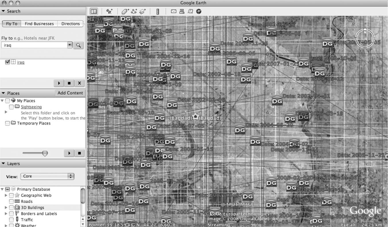
After January 2002 when the exclusive licenses expired, Space Imaging made Ikonos satellite images of Afghanistan commercially available. And in a matter of years Afghanistan went from being a highly guarded and secured information space to one in which its territories, imaged from orbital and aerial platforms, suddenly became digitized lands for anyone to navigate. Indeed by 2005 the entire territory of Afghanistan was available as a composite of satellite and aerial imagery in Google Earth and had become datalands for sale. One contributor to these composites is the US company Digital Globe (DG), owner of the QuickBird satellite. DG licenses images to Google for use in the Google Earth database. The company also uses Google Earth as a platform for selling satellite images of Afghanistan (and other countries around the world) to private parties. At the interface, color-coded squares and DG icons appear in the visual field. The color-coded squares (sometimes called scene footprints) function as traces of a satellite’s pass over a specific part of the earth. When composited, as in Figure 5.3, they form a historical record of satellite image data acquisitions, as well as a slice of DG’s inventory. Clicking on a DG icon opens a frame with data about the image including the acquisition date, cloud cover, and an environmental quality rating. If the user clicks on “preview,” she enters a meta-browser featuring the single satellite image captioned with information about how to purchase it or others from DG.
Figure 5.3 Screen capture of Google Earth revealing the landscape of Iraq as a digital, navigable landscape for (re)development or sale by companies such as DG and Google.
The United States may have restricted access to satellite imagery of Afghanistan for three months in 2001, but now it allows Google, DG, and Space Imaging to conduct an international business that turns Afghani and Iraqi territories (as well as those of other countries) into intellectual property produced, owned, and distributed by US corporations. This is symbolically reinforced by the inscription of these companies’ brand names within Google Earth’s mediascapes. Just as the leveling of communication infrastructure provided opportunities for US contractors to restructure and rebuild Afghan and Iraqi broadcast and telecom systems, the Google Earthing of Afghanistan and Iraq boosts the business potentials and profits of US companies as the satellite image has been used both to showcase the eradication of Taliban and Hussein communication systems and as a platform upon which to imagine, design, and map new ones. This is vividly demonstrated by an Open Source Center layer called Media Mapping, Iraq, which uses Google Earth to visualize the plethora of television and news networks that have emerged in Iraq in the midst of the ongoing war, many of which are owned by foreigners. Interestingly, the introduction page to this layer warns that this map “is not intended for targeting. The accuracies of the project were created from coarse data.”
In fact, other Google Earth images have been used for targeting by insurgents and terrorists. Since the application first emerged in 2005 leaders from the United Kingdom, Netherlands, Morocco, South Korea, India, Australia, and Israel among others have argued that these “interfaces to the planet” arouse serious concerns about national sovereignty and can be used by terrorists or others to organize attacks on facilities in their countries. For instance, Indian President A.P.J. Abdul Kalam complained that such open source intelligence is a problem for developing countries. He showed satellite and aerial images of sensitive sites in India available online to local police officers suggesting they could be used by terrorists or Pakistanis who have had tense relations with India.26 In 2005, Australian leaders complained that its Lucas Heights nuclear reactor and Garden Island military installation were visible and could be easily targeted by terrorists.27 The South Korean government has indicated the locations of its military installations and the Presidential Blue House are identified in Google Earth and could be used by North Korea.28 In the United States, state and federal officials make regular requests for certain areas to be censored and there are many areas that are blurred or covered with colored blocks.29 In 2009, a California assemblyman introduced legislation designed to blur “soft targets” throughout the state including schools, hospitals, churches, and government buildings in an effort to protect them from “terrorists.”30 In response to such concerns, Google has censored certain facilities represented within Google Earth by blurring them.31 The company has blurred sites in India, Kosovo, the Netherlands, and New York.32 Shutter control thus has shifted from being a state decision to a financial transaction to a digital effect.
Despite this practice of blurring, Google Earth and Google Maps have been used by groups ranging from insurgents in Iraq to terrorists in Mumbai.33 In January 2007 Iraqi insurgents allegedly used Google Earth printouts in an effort to orchestrate attacks on British coalition soldiers stationed in Basra. As the British Telegraph reported,
Documents seized during raids on the homes of the insurgents … uncovered print-outs from photographs taken from Google. The satellite photographs show in detail the buildings inside the bases and vulnerable areas such as tented accommodation, lavatory blocks where lightly armored Land Rovers are parked.34
Amidst reports that Google Earth images were being sold to rogue militias at a market place in Basra, British soldiers said they would consider suing Google if injured by mortar rounds that had been directed on the camp because of Google Earth views.35 Google responded to the incident by changing images of this area in the Google Earth database. These changes were discovered after a “forensic examination” conducted by Stefan Geens, who showed in the online journal Ogle Earth that Google replaced newer imagery showing impact craters and army installations with older ones pre-dating the war.36
Google claims that it avoids altering satellite images and alleges that this practice is conducted by satellite image companies before they are submitted to Google.37 Yet in 2007 John Hanke, director of Google Earth and Maps explained,
Google has engaged, and will continue to engage, in substantive dialogue with recognized security experts and relevant agencies worldwide. While we’re unable to provide details of these discussions, the dialog may, in some rare cases, result in a change of image availability.38
There have been so many Google Earth images “censored” that a user community has formed to track them and applies blue shading to highlight obscured areas.39 Lists of censored sites also are available on wikipedia and they abound in the press.40
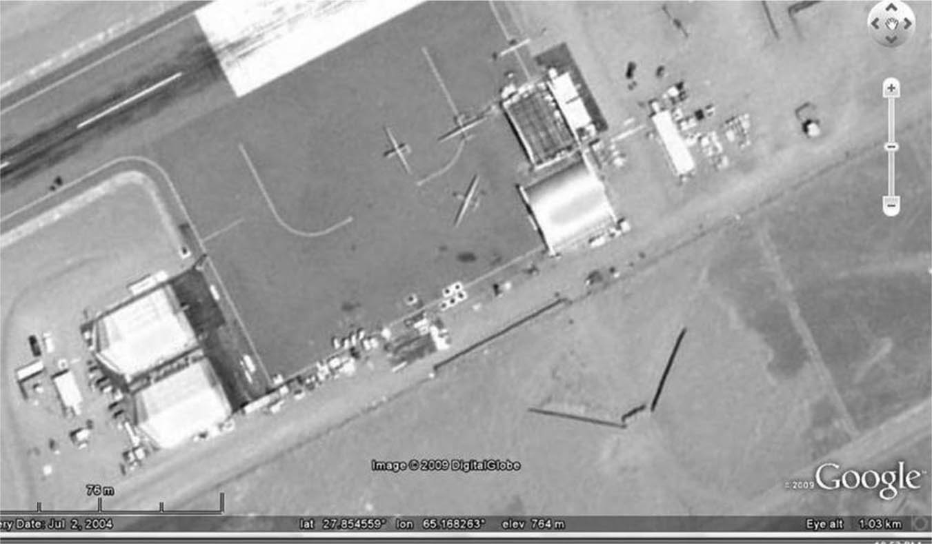
While it may seem that Google Earth’s emergence conflicted with the logic of shutter control by making high-resolution satellite images available to the global public during a time of war, I want to suggest that Google’s “patchwork censorship” represents the neoliberal outsourcing and digitization of shutter control and acts of state diplomacy. Now commercial satellite operators and Google engage directly with states and determine whether to quietly restrict access to or doctor satellite images in their possession. Because of the enormous volume of satellite image data in Google Earth, these censorship practices are often noticed only by chance or when there is a major news event. In February 2009, the politics of shutter control came full circle when a secret CIA base in Shamsi Pakistan reportedly being used to stage the monitoring and bombing of Al Qaeda targets near the Afghan Pakistan border was exposed in Google Earth (see Figure 5.4). The international community, and Pakistanis in particular, questioned the US government about the base, but received no confirmation and the satellite image was rapidly replaced.41 Such are the practices of the age of the world target: when the CIA’s military violence and Google Earth’s digital “peacekeeping” are conducted collaboratively and in the window of a virtualized world.
Figure 5.4 Screen capture from Google Earth allegedly revealing three predator drones at a CIA base in Shamsi, Pakistan.
Conclusion
I want to close with three points: First, for every satellite view we need to conceptualize or imagine a reverse shot that would lead us to the orbital location, history, ownership of the satellite that gathered the image data. This is a call for a vertical and techno-reflexive way of writing history and conducting analysis, one that accounts not only for players, events, and objects on earth but also for the multitude of powerful objects and operations that surround the planet and shape relations upon it, a call for greater critical awareness of the vertical space that stretches from the earth’s surface, through the atmosphere and ionosphere, and into the low, medium, geostationary, and supersynchronous orbits that satellites occupy.
Second, the destruction of communication infrastructures is not only an attack on the central nervous system of authoritarian regimes; it is a bellwether for postwar nation-building projects engineered to support US economic and geopolitical interests. The satellite image provides a window onto such processes not just by spotlighting and confirming the moment of destruction but by challenging us to ask what will follow. That is to say, the satellite image intimates and anticipates futures as much as it reveals presents or pasts. Since it is also laden with strategic power, its use challenges us to look beyond the arrows of the Defense Department and continually ask how can satellite images be used to produce knowledge in ways that are not warfare’s accomplice?
Finally, the politics of Google Earth are complex and the issues of sovereignty it raises date back further than the age of the Internet and relate to various international treaties and the legal definitions of the nation-state as well as extraterritorial domains such as the spectrum, the air, orbit, and the oceans. There is a long history of US attempts to assert ownership and control over these extraterritorial domains – and this is manifest in what I have discussed not only in its claims to restructure the electromagnetic spectrum of and for others but also in the process of using orbital space to turn the national territories of all countries, oceans, and skies into datalands either for sale or for censorship by US corporations. The political effects of Google’s worlding maneuvers – a company’s whose motto is “don’t be evil” – are yet to be fully assessed. Suffice it to say that the power to represent the earth in this way is an enormous power that needs to be evaluated most carefully in the age of the world target – in a time where the United States exercises the privilege to wage war and preach peace at one in the same time.
Notes
1 These are verb phrases associated with “zero” listed at Dictionary.com, http://dictionary.reference.com/browse/zeroing+in, accessed April 6, 2011.
2 Paul Virilio, Strategy of Deception (London: Verso, 2001); Kevin Robins, Into the Image: Culture and Politics in the Field of Vision (London: Routledge, 1996); and Jody Berland, “Mapping Space,” in North of Empire (Durham, NC: Duke University Press, 2009), 242–272.
3 Rey Chow, The Age of the World Target: Self-Referentiality in War, Theory, and Comparative Work (Durham, NC: Duke University Press, 2006), 31.
4 Ibid., 38.
5 Lisa Parks, “Digging into Google Earth: An Analysis of ‘Crisis in Darfur,”’ Geoforum, Vol. 40 (July 4, 2009): 535–545.
6 See, for instance, Michael Parenti, “The Rational Destruction of Yugoslavia,” November 1999, www.michaelparenti.org/yugoslavia.html, accessed April 6, 2011; Parenti, To Kill A Nation (London: Verso, 2001); and Lisa Parks, “Postwar Footprints: Satellite and Wireless Stories in Slovenia and Croatia,” in B-Zone: Becoming Europe and Beyond, Anselm Franke, ed. (Barcelona: Actar Press, 2005), 306–347.
7 Michael J. Barker, “Democracy or Polyarchy? US-funded Media Developments in Afghanistan and Iraq post 9/11,” Media, Culture and Society, Vol. 30 (1): 109–130, 119.
8 See for instance overhead images of US attacks on Darunta Camp Complex here http://www.globalsecurity.org/military/world/afghanistan/darunta.htm, accessed April 12, 2011; and overhead images of US attacks on Bagram Airbase at http://www.globalsecurity.org/military/world/afghanistan/bagram-imagery.htm, accessed April 12, 2011.
9 These images are archived in the image intelligence gallery of the Federation of American Scientists, http://www.fas.org/irp/imint/afghan.htm, accessed July 5, 2005.
10 These images are included in this report: Jeffrey Richelson, ed., “Eyes on Saddam: Overhead Imagery of Iraq,” National Security Archive Electronic Briefing Book No.88, April 30, 2003, http://www.gwu.edu/∼nsarchiv/NSAEBB/NSAEBB88/, accessed April 12, 2011.
11 Histories of photo intelligence interpretation.
12 Lisa Parks, Cultures in Orbit: Satellites and the Televisual (Durham, NC: Duke University Press, 2005), 96–107.
13 Nicholas Mirzoeff, Watching Babylon: The War in Iraq and Global Visual Culture, (London: Routledge, 2005), 73–74.
14 Ibid., 74.
15 “US Pursuing New Spy Satellite Program,” Geopolitical Monitor, December 3, 2007, http://www.geopoliticalmonitor.com/us-pursuing-new-spy-satellite-program-084/, accessed April 5, 2011. Need source for 180 satellites – Paglen’s book.
16 Trevor Paglen, The Other Night Sky art exhibition, Berkeley Art Museum, 2008. Also see “The Other Night Sky,” Trevor Paglen’s website, http://www.paglen.com/pages/projects/other_night/index.html, accessed April 6, 2011.
17 Raphael Prober, “Shutter Control: Confronting Tomorrow’s Technology with Yesterday’s Regulations,” Journal of Law and Politics, Spring 2003. Also see James Keeley and Robert Huebert, eds., Commercial Satellite Imagery and United Nations Peacekeeping: A View From Above, Ashgate, 2004.
18 For a broad discussion of the implications of shutter control see Ann M. Florini and Yahya Dehqanzada, “Commercial Satellite Imagery Comes of Age,” Issues in Science and Technology, 16.1, Fall 1999, http://www.issues.org/16.1/florini.htm, accessed April 5, 2011.
19 Cheryl Arvidson, “Journalists denounce government ‘shutter control’ idea for satellite images,” March 17, 2000, The Freedom Forum Online, http://www.freedomforum.org/templates/document.asp?documentID=11944, accessed April 6, 2011.
20 Barbara Cochran, “Fighting the Feds Over Shutter Control,” Communicator, December 1999, 113–115, http://www.rtdna.org/pages/media_items/fighting-the-feds-over-shutter-control210.php, accessed July 3, 2008.
21 Ibid., 113.
22 Ibid., 113–115.
23 See Jessica Altschul, “Commercial Satellite Imagery Poses a Challenge to Pentagon Planners,” February 28, 2002, GlobalSecurity.org website, http://www.globalsecurity.org/org/news/2002/020228-eye.htm, accessed April 6, 2011.
24 Joan Johnson-Freese, Space as a Strategic Asset (New York: Columbia University Press, 2007), 112.
25 Katherine Shrader, “Curbs on Satellite Photos May be Needed,” San Francisco Chronicle, May 8, 2007, accessed July 3, 2008; David Corn, “Their Spy in the Sky,” The Nation, November 8, 2001, http://www.thenation.com/doc/20011126/corn, accessed July 4, 2008. Duncan Campbell, “US Buys Up All Satellite War Images,” The Guardian, October 17, 2001, http://www.guardian.co.uk/world/2001/oct/17/physicalsciences.afghanistan, accessed April 6, 2011.
26 Barry Levine, “Does Google Earth Reveal Military Secrets?” News Factor Network, June 27, 2006, http://www.globalsecurity.org/org/news/2006/060627-google-earth.htm, accessed April 6, 2011.
27 Karen Barlow, “Google Earth Prompts Security Fears,” ABC Online, August 8, 2005, http://www.abc.net.au/news/indepth/featureitems/s1432602.htm, accessed July 3, 2008. Also see Jano Gibson, “Lucas Heights nervous about Google gander,” Sydney Morning Herald, http://www.smh.com.au/news/technology/lucas-heights-nervous-about-google-gander/2005/08/08/1123353245458.html, accessed April 6, 2011.
28 “Google Earth Mapping Service Draws Complaint from South Korea,” The New York Times, September 1, 2005, http://www.nytimes.com/2005/08/31/technology/31iht-google.html, accessed April 6, 2011; Lester Haines, “South Korea Throws Strop at Google Earth,” The Register, August 31, 2005, http://www.theregister.co.uk/2005/08/31/google_earth_korea/, accessed April 6, 2011.
29 Verne Kopytoff, “Top Secret, in Plain View: Google Earth May blur the Image, but others don’t,” San Francisco Chronicle, May 18, 2007, http://www.sfgate.com/cgi-bin/article.cgi?f=/c/a/2007/05/18/GOOGLE.TMP, accessed July 3, 2008.
30 Miguel Helft, “California Lawmaker Wants Online Map Images Blurred,” The New York Times, March 3, 2009, http://bits.blogs.nytimes.com/2009/03/03/california-lawmaker-wants-online-map-images-blurred/, accessed April 6, 2011.
31 John Byrnes, “Google Increasingly Compliant with Censorship Requests: US Intelligence Report,” The Raw Story, August 26, 2008, http://rawstory.com/news/2008/Google_Earth_compliant_with_government_requests_0826.html, accessed April 6, 2011.
32 “Google Earth to Blur Key India Sites,” SpaceDaily.com, February 4, 2007, http://www.spacedaily.com/reports/Google_Earth_To_Blur_Key_India_Sites_999.html, accessed April 6, 2011. Philip Lenssen, “Google to Censor India Satellite Imagery,” blogoscoped.com, February 4, 2007, http://blogoscoped.com/archive/2007-02-04-n63.html. Also see Frank Patalong, “Das zensierte Weltauge,” Spiegel.online, February 4, 2007, http://www.spiegel.de/netzwelt/web/0,1518,464186,00.html, accessed April 6, 2011.
33 Damien McElroy, “Mumbai Attacks: Surviving Terrorist says he Belonged to Pakistan Militant Group,” The Telegraph, November 30, 2008, http://www.telegraph.co.uk/news/worldnews/asia/india/3537203/Mumbai-attacks-surviving-terrorist-says-he-belonged-to-Pakistan-militant-group.html, accessed April 6, 2011.
34 Thomas Harding, “Terrorists Use Google Maps to Hit UK Troops,” The Telegraph, January 13, 2007, www.telegraph.co.uk/news/worldnews/1539401/Terrorists-%27use-Google-maps-to-hit-UK-troops%27.html, accessed July 1, 2008; “Google Earth, Insurgents’ Friend?” defensetech.org, January 13, 2007, www.defensetech.org/archives/003163.html, accessed July 1, 2008.
35 Thomas Harding, “Terrorists Use Google Maps to Hit UK Troops,” The Telegraph, January 13, 2007, www.telegraph.co.uk/news/worldnews/1539401/Terrorists-%27use-Google-maps-to-hit-UK-troops%27.html, accessed July 1, 2008. There were also reports that the GE images were being sold to rogue militias at a market place in Basra.
36 Stefan Geens, “Did Google Censor Basra Imagery?” Ogle Earth, January 14, 2007, www.ogleearth.com/2007/01/did_google_cens.html, accessed July 1, 2008. For further challenges to the Daily Telegraph report see Stefan Geens, “Basra: Daily Telegraph has no clue,” Ogle Earth, January 20, 2007, http://ogleearth.com/2007/01/basra-new-daily-telegraph-article-has-no-clue/, accessed April 6, 2011; also see Noel Jenkins, “Terrorists read Ogle Earth not the Daily Telegraph,” Juicy Geography’s Google Earth Blog, January 14, 2007, www.juicygeography.co.uk/blog/?p=99, accessed July 1, 2008.
37 http://www.slate.com/id/2205755/
38 Verne Kopytoff, “Top Secret, in Plain View: Google Earth May blur the Image, but others don’t,” San Francisco Chronicle, May 18, 2007, http://www.sfgate.com/cgi-bin/article.cgi?f=/c/a/2007/05/18/GOOGLE.TMP, accessed July 3, 2008.
39 Verne Kopytoff, “Top Secret, in Plain View: Google Earth May Blur the Image, but Others don’t,” San Francisco Chronicle, May 18, 2007, www.sfgate.com/cgi-bin/article.cgi?f=/c/a/2007/05/18/GOOGLE.TMP, accessed July 3, 2008.
40 See “Satellite Map Images with Missing or Unclear Data,” Wikipedia, http://en.wikipedia.org/wiki/Satellite_map_images_with_missing_or_unclear_data, accessed April 12, 2011; or “Google Earth Cool Places – Censored Stuff,” http://www.googleearthcoolplaces.com/censored.php, accessed April 11, 2011.
41 Jeremy Page, “Google Earth Reveals Secret History of US Base in Pakistan,” The Times, February 19, 2009, http://www.timesonline.co.uk/tol/news/world/asia/article5762371.ece, accessed April 11, 2011.