
Environmental Well-Being in the Yellowstone River Valley
Introduction
We turn our attention to a second key concern for sustainability theory and practice: the long-term well-being of the environment. Our case study leads us to examine two environmental concerns in the Yellowstone River Valley. To begin, we will learn about the Pallid Sturgeon—a federally protected, endangered fish species—and we will examine efforts to save this species. Next, we will look at the cottonwood forests of the valley, where, in some areas, it appears that tree reproduction and growth are not occurring as expected. We will learn why these impressive and much-loved trees are potentially threatened. In both examples, it appears that human practices, especially practices of the 20th century, have affected environmental health and well-being.
Long-Term Well-Being of Pallid Sturgeon
In general, and for some time, conservation biologists have worried that we are losing variety among the species of the Earth (Soulé 1985), and the potential loss of a prehistoric fish species is troubling. Yet today, despite surviving many fluctuations in weather, climate, and harvesting pressures over the ages, some of our oldest fish species are in crisis. The Pallid Sturgeon (Scaphirhynchus albus) is one such species. It is a rare fish that appears to be mostly unchanged over 78 million years (Jordan 2013). Sometimes referred to as “living dinosaurs,” individual Pallid Sturgeon start small (Figure 3.1), but they often grow to six feet in length and well over 75 pounds, especially those occupying northern habitats, such as near the confluence of the Missouri and Yellowstone Rivers. Even though predatory, they are generally bottom dwellers, moving through the lower murkiness of river waters.
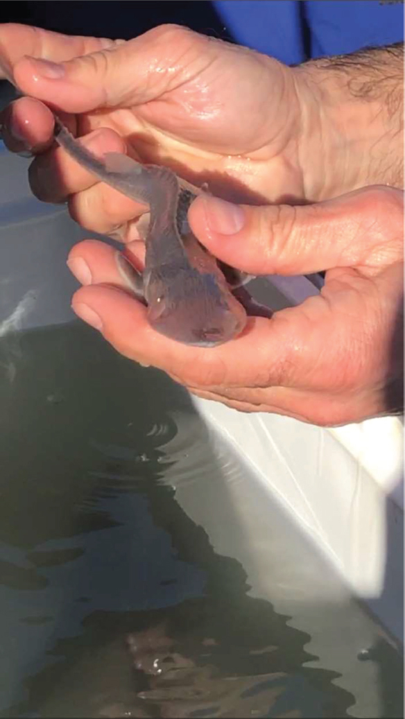
Figure 3.1 Fingerling Pallid Sturgeon at Miles City Hatchery
The historical habitat of the Pallid Sturgeon extended from the lower Mississippi River at the Gulf of Mexico into the far reaches of the Upper Missouri (Jordan 2013). Habitat also included the warm-water region of the Yellowstone River, extending from its confluence with the Missouri River in North Dakota to the transition zone (colder waters) near Billings, Montana. In earlier times, Pallid Sturgeon would have also spawned in the Powder and Tongue Rivers (Backes 2020), which are warm-water tributaries that enter the lower Yellowstone River near Terry and at Miles City, respectively (see border of Reaches C21 and D1). In the area of the Yellowstone and Missouri River confluence (Reach D16), these fish do not reach reproductive maturity for over 20 years, and they can live for more than 60 years. The Pallid Sturgeon of the confluence are believed to live, on average, 20 years longer than their cousins in the midwestern and southern states because the winter season in the north is comparatively elongated. It is theorized that the longer periods of cold, and, thus, longer periods of reduced metabolic rates, result in slower development and maturation of the Pallid Sturgeon in Montana (Backes 2020).
Beginning in the 1960s, state and federal biologists noted a sharp decline in the number of Pallid Sturgeon, and in 1990, the species was listed as endangered under the guidelines of the Endangered Species Act (ESA) (Jordan 2013). Federal authorities were required to develop a recovery plan that would account for the primary causes of the population decline and identify specific projects and methods that could reverse the trend. The original recovery plan of 1993 and the revised recovery plan of 2013 identified three factors contributing to the declining populations. Each of these factors resulted from human activities that were begun early in the 20th century without much thought as to how the projects or practices might affect fish species.
The first cause of population decline is attributed to the many reservoirs on the Missouri River system (Jordan 2013). By the 1960s, the Missouri River was essentially held in a series of impoundments, with comparatively little free-flowing river. Moreover, the reservoirs are held in place by dams that forestall fish passage to their historical reaches. Indeed, by 1990, the Missouri River had functioned for more than 30 years as a series of lakes, rather than as a flowing river. Today, with their historical ranges functionally divided, some communities of Pallid Sturgeon have lived in isolation for over 100 years.
Second, efforts to control river channels and to reduce flood potential have led to significant reductions in the number and lengths of side channels (Jordan 2013). Side channels have long been purposefully blocked to avoid flooding on private properties and, often, to claim land that might otherwise be inaccessible to landowners for agricultural or developmental purposes. Even ephemeral channels, those that have water only during the spring, are often blocked. The idea behind blocking side channels is always the same: keep the river contained. The loss of side channels is problematic for the Pallid Sturgeon because the side channels are where spawning occurs and are, therefore, essential for successful reproduction. Also, juveniles need to spend some time in these side channels to build up their strength as swimmers before entering the main channels of larger rivers.
Third, where irrigation water is extracted, fish can be drawn into irrigation canals, a process known as entrainment. Once fish are in the canals, there is virtually no chance of survival (Jordan 2013). Entrainment is an issue for all fish species in the Missouri and Yellowstone Rivers, but when a species is in decline, the entrainments are especially regrettable. Together with the other two human-caused changes, entrainment has negatively affected the habitat range and character, the reproductive success, and the life-expectancies of the Pallid Sturgeon.
In an attempt to stem the precipitous Pallid Sturgeon decline, federal and state agencies began hatching programs. The National Fish Hatchery at Garrison Dam on the Missouri River in North Dakota began collecting wild adult Pallid Sturgeon in 1988. Since then, the hatchery has been breeding adults and raising juveniles (U.S. Fish and Wildlife Service 2020). When released to the wild, the survival rates of these hatchery-raised fish were not particularly good during the early years, but with the introduction of resistance flows in hatchling tanks, the success rates of released juveniles have greatly improved. Another hatchery, the Miles City Fish Hatchery managed by the Montana Department of Fish, Wildlife and Parks, housed three male Pallid Sturgeon that were each believed to be more than 80 years in age. As denizens of the local domain, these males produced milt (seminal fluid) that was considered especially valuable (Montana Fish, Wildlife and Parks 2016a).
Mike Backes is the senior fish biologist for Pallid Sturgeon recovery in Montana. He lives in the lower valley and has spent more than 30 years studying the Pallid Sturgeon of the area. Recently, he explained that nearly every hatchling from Miles City is electronically tagged and fitted with a transmitter (Backes 2020). This allows biologists to track the released stocks. In fact, some individual Pallid Sturgeons have been monitored for more than 20 years. The biologists even track wild individuals (i.e., those that hatched in the river and not in a hatchery) when they can catch them and fit them with tags and transmitters. In correspondence, Backes explained some of the difficulties in tracking an individual Pallid Sturgeon:
[This spring] we caught a wild male. He was a priority fish to capture in 2020, [but] catching him was a complete surprise because the transmitter had died and was no longer functioning. We installed a new transmitter and released him. The expected battery life of the new transmitter is eight years. (Michael Backes, e-mail message to Susan Gilbertz, July 06, 2020)
He also mentioned a large female caught by the field team in 2020 (Figure 3.2):
We sampled an area of the Yellowstone River … to find “Female Code 43.” We wanted to determine if she would spawn in 2020. We had intel from other staff that she was in the area. We were lucky enough to find and capture her by using telemetry equipment and a trammel net. She was full of eggs, and she is the largest Pallid Sturgeon I have ever seen. … [Later,] I learned that she actually never spawned and is atretic—reabsorbing the eggs. We have no understanding why she is atretic. This is rarely seen in adult Pallid Sturgeon. (Michael Backes, e-mail message to Susan Gilbertz, July 06, 2020)
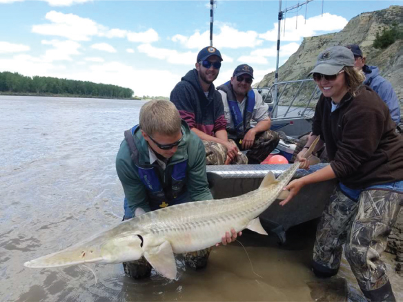
Figure 3.2 Tagged Pallid Sturgeon, full of eggs
Photo: Mike Backes
Beyond directing the operation of hatcheries, Pallid Sturgeon recovery plans also identified areas for habitat improvements. The plans noted that, in the northern waters, overall recovery would be enhanced if the Pallid Sturgeon had access to a much greater extent of the warm-water habitats on the Yellowstone River and its warm-water tributaries (Jordan 2013). The recovery plans also called upon river managers to address the fish blockage caused by the irrigation facility at Intake.
You will remember that Intake provides irrigation water to over 58,000 acres of farmland in the lower Yellowstone River Valley (Reach D8). Remember, too, that Intake needs a pool from which it can draw irrigation water. At Intake, a pulley system stretches across the river to deliver rocks across the entire span of the river channel. The rocks, and the wooden “cribs” that they fall into, function as a small dam, a weir. This weir is approximately five feet in height and creates a pool of water on the upriver side of the rocks. Once there is adequate depth in the pool to allow water to flow through the irrigation headgate and into the main irrigation canal, no further rocks are added, and water flows both into the canal and over the rock weir. Each spring, after high waters have torn away at the weir, more rocks are delivered to (again) raise the height of the weir, again to about five feet. Throughout the valley, residents refer to Intake and to similar rock weirs as diversion dams. Intake is the largest diversion dam facility on the Yellowstone River. These weirs do not stop all water from flowing downstream, and the Yellowstone River is still known as the longest free-flowing river in the continental United States.
For the Pallid Sturgeon, the rock diversion dam at Intake is generally insurmountable (Jordan 2013). The Pallid Sturgeon, which tend to swim along the bottom of the river, encounter the rock structure and have no instinct for negotiating its height. Thus, even though the river continues to flow, and even though a five-foot rock weir may seem insignificant, it is a blockage for most Pallid Sturgeon. Very few successfully navigate the weir or find their way to the side channel that can afford them access to their historical spawning areas above Intake. Of the few that make it past Intake, even fewer manage to make it to the Powder or Tongue Rivers (Backes 2020).
Local fish biologists play an important role in the Pallid Sturgeon recovery efforts. Not only are their data important to understanding the species but they also show just how rare it is for Pallid Sturgeon to get upriver from Intake. The biologists get excited when they find Pallid Sturgeon upriver from Intake:
We continue to learn more every year. Two Pallid Sturgeon, a wild male and a juvenile, used the Tongue River this year. They were in the Tongue River for nearly two weeks. This is the first documented use of a Pallid Sturgeon in the Tongue River since an angler caught one in 1950. (Michael Backes, e-mail message to Susan Gilbertz, July 06, 2020)
The biologists are also amazed by certain individuals they have tracked for several years:
[This spring] a wild female went up the Yellowstone River to within a few miles of … Hathaway. [In the past,] the farthest a female had gone upstream of Intake was the Powder River confluence in 2012. Ironically, it’s the same fish. And, she migrated 20 miles up the Powder River in 2014. (Michael Backes, e-mail message to Susan Gilbertz, July 06, 2020)
According to the ESA, once the causes for a population decline are identified, remedies must also be identified and evaluated in terms of costs and potentials for effectiveness. With Intake functioning as a fish blockage, two alternative remedies were given a great deal of attention and consideration. First, a rock ramp was evaluated as a means of helping the Pallid Sturgeon negotiate the height of the rock weir. The idea was to place materials in the river below the weir, creating a gradual incline of small steps to the top of the diversion dam. The Pallid Sturgeon would need pools where they could rest before negotiating each next-higher level, and the overall length of the rock ramp was estimated at over a half mile (Jordon 2013). Second, an enhanced bypass channel was considered. You will recall that there is a natural side channel in this area. However, because the Pallid Sturgeon has no natural instinct to seek an alternative path, the bypass channel “exit” from the main stem of the river needed to be enhanced in a location where the Pallid Sturgeon would likely encounter it as a reasonable path forward. However, it was assumed that even with an enhanced exit, many of the Pallid Sturgeon would miss the bypass channel and still not be able to negotiate the height of the dam. The rock ramp was considered the better alternative in terms of both likely success and overall costs (Jordon 2013).
Regardless of the method for getting Pallid Sturgeon upstream from the diversion dam, once they were above the dam, they would have faced the added peril of possible entrainment through the irrigation headgate and into the main canal. This entrainment issue led some farmers in the area to be concerned that their entire irrigation system was at risk:
There’s a push to get rid of the Intake dam, which is not really a dam, it slows the water down so it can come in the canal. Well, they’re wanting to do away with that, and that would be impossible because those farmers can’t afford to pay for a pumping project. (Farmer near Intake 2006)
The farmers worried that the entire irrigation facility would be shut down in favor of a truly free-flowing river. A joint effort by the Bureau of Reclamation and the Army COE, completed in 2012, alleviated most of those concerns. Officials decided to address the entrainment issues first by installing a new headgate that provides irrigation water that is equipped with screens to keep the fish out of the canal. The new structure is just upstream from the older headgate (Figure 3.3).
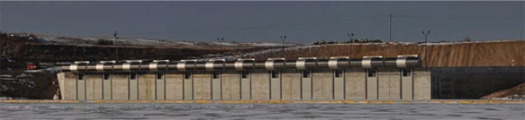
Figure 3.3 New headgates at Intake
Photo: Bureau of Reclamation
Unfortunately, in 2013, the rock ramp alternative was deemed not feasible (U.S. Bureau of Reclamation 2018). The problem was that only approved materials could be placed in the river (i.e., blocks of granite), and these materials were much more expensive than anticipated. When potential contractors submitted bids for the project, their figures were consistently twice the amount estimated by design engineers. The rock ramp was no longer financially feasible, and managers returned to the notion of the enhanced bypass channel. Because of the change in plans, the next seven years were punctuated by lawsuits, injunctions, reevaluations, and revised planning. Each turn in the story was reported in local newspapers. A complete account of the fits and starts will not be fully discussed here. Instead, a few of the important junctures are outlined as follows.
By 2016, a new analysis was prepared that, again, considered the alternative courses of action. At this juncture, it was estimated that the rock ramp would cost nearly $60 million. In comparison, the bypass alternative would cost approximately $50 million. As such, the rock ramp was no longer the first choice (U.S. Bureau of Reclamation 2016). The managing agencies argued that the bypass project should be approved, and they opened a new bidding process. The associated costs of the new plan surprised community members. One McKenzie County, North Dakota farmer described it as, “ridiculous … with the amount they’re talking, you could give each [Pallid] a limousine ride up there every day for a long time” (2006). Then, before the bypass decision was finalized, legal injunctions to stop the bypass project were filed by the advocacy group Defenders of Wildlife (Brown 2015). This group’s primary purpose is to “prevent species and their habitats from becoming imperiled” (Defenders of Wildlife 2020). The suit argued that the bypass would not solve the problem because most fish would continue to miss the exit from the main channel. The injunctions were upheld, but the COE appealed the decision.
In April 2018, the 9th Circuit Court ruled that the lower court had erred in issuing the injunction (Jean 2018). The Circuit Court had cleared the way for the project to start, but the construction contracts had already been canceled, forcing authorities to conduct new environmental and cost analyses before announcing a new bidding process. Later in 2018, the project was announced, this time to include the bypass channel and a new replacement weir (diversion dam). By this time local farmers seemed mostly satisfied that, although it is an expensive solution, the new Intake headgate would work for irrigation. People had come together for a common cause:
About the Pallid Sturgeon and the Intake thing, most people are all on the positive side. “Let’s get this thing done. Let’s help out the fish and help out the farmers. Water for the fish, and water for the farmers.” … But they put in these expensive fish screens and … these screens get all the mud and whatnot. They have to lift them out every so often and hose the mud off of them because the Yellowstone is really a muddy river. It has all kinds of debris in it, too. So anyway, they spend a lot of money on those fish screens, to keep the fish out of the canal. (Farmer near Sidney 2018)
Another farmer explained that even though he had lingering concerns about the motives of advocacy groups, he was satisfied with the bypass channel:
I still don’t think they’re going to be happy until the dam, or the weir, is gone. But I think the fish bypass will work. It’s proven that it works over in France. I don’t know why it wouldn’t work here. Heck, it gives the fish more surface to go swim, more area. You know, I think it’s a good idea, and it serves both purposes. It would keep the fish happy, and it would keep us happy. (Farmer near Sidney 2018)
Yet another twist occurred in January 2019. As soon as the latest bidding process was completed, a losing bidder challenged the contract, forcing another delay (Stuart 2019). Within a few months, that challenge was dismissed by the court. In July 2019, the work at Intake was finally underway (Herbaugh 2019).
We can think about the ESA as an environmental sustainability agenda, one designed to recover a species to the extent that their long-term well-being is no longer in doubt. Unfortunately, in the case of the Pallid Sturgeon, the end goal is still very remote. Even if the bypass channel and the new headgates work as desired, it seems unlikely that the species can survive without continuing human intervention in the reproductive processes of the Pallid Sturgeon: “As for their sustainability, it doesn’t seem possible without the hatcheries” (Michael Backes, e-mail message to Susan Gilbertz, July 06, 2020).
Long-Term Sustainability of the Cottonwood Forests
As a second example of environmental sustainability in the Yellowstone River Valley, we will next examine the health and well-being of the cottonwood forests. These forests are important to the local landscape. They send off millions of cotton-tufted seeds in the spring, they are colorful harbingers of autumn, and they provide habitat for many species of birds, some rare and some common. As a personal anecdote, when one author participated in a winter canoe float near Billings, she witnessed 12 pairs of Bald Eagles living in cottonwood trees in the space of only about five river miles. These eagles were easy to spot because the foliage was off the trees, and some were fishing the river as her canoe passed. Throughout the Yellowstone River Valley, locals and visitors are struck by the beauty of these forests and by the avian communities that depend on them for habitat.
It is easy to find old growth cottonwood forests near the Yellowstone River (Figure 3.4). Local residents throughout the Yellowstone River Valley appreciate the cottonwoods as giants of arboreal magnificence, and many landowners can prove that individual cottonwood trees have survived on their properties for well over 100 years (Gilbertz, Horton, and Hall 2006). They refer to historical photographs of family picnics and weddings held in the shady areas down near the river. Often, the cottonwood trees in their backyards are living legacies of the efforts and toils of great-grandparents who wanted to leave the immediate environment in better condition for their progeny. One retiree, who moved from Billings to live outside of town and on the riverbank, explained the affections of his wife and himself, “We love cottonwood trees … Picture this place without a cottonwood or with no trees, it would be the Sahara Desert. We love the trees” (Riverbank Retiree near Grey Cliff 2018).
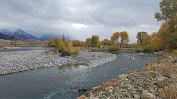
Figure 3.4 Cottonwood Forest in Fall
The plains cottonwood (Populus deltoides, subspecies monilifera) is prevalent in the lower Yellowstone River Valley (Dixon et al. 2012), and the narrowleaf (Populus angustifolia) is the dominant cottonwood in the upper valley near Gardner (see Merigliano, Friedman, and Scott 2013). Individual cottonwood trees will not reach seed-bearing age until their 10th year, and they will not reach full development until they are 40 or 50 years old (Cooper and Van Haverbeke 1990). They require good sunlight; thus, invasive trees and shrubs can negatively affect the success of juvenile cottonwood trees if the invasive trees create too much shade. However, under favorable conditions, many cottonwoods will easily live over 90 years, and the oldest known trees have survived for over 300 years (Friedman and Griffin 2017). Specific to the Yellowstone River basin, research shows that some cottonwood trees in the Powder River and the lower Yellowstone River drainages are over 270 years old (Schook, Friedman, and Rathburn 2016).
Cottonwoods are considered “thirsty” and many stands are aged. They need to tap into reliable groundwater to survive (Scott, Auble, and Friedman 1997). Therefore, they tend to do well on river and streambanks (Lesica 2012). However, in some regions and watersheds, cottonwood forests are made up of mostly mature trees (Braatne et al. 2007). Across Montana, including many areas of the Yellowstone River Valley, there is an apparent lack of young cottonwood trees, and an “aging out” of the forests has been noted for at least two decades (Auble and Scott 1998; Dixon et al. 2012; Johnson et al. 2012). In 2013, in the upper river near Gardiner, researchers found a “scarcity of trees less than about 100 years old” (Merigliano, Friedman, and Scott 2013, 161).
A study of avian species in the Yellowstone River Valley by Jones (2014) offers direct and indirect evidence of forest decline. For ecologists, select species can serve as indicator species, which means that patterns of their presence or absence can be interpreted as a measure of overall richness (i.e., number of species) and completeness of a larger suite of organisms (i.e., biotic community; Fleishman et al. 2005). In this way, indicator species serve to help assess the overall health of an ecosystem. Because some groups of birds have similar habitat and resource requirements, those species will collectively avoid areas where the habitat is no longer suitable. As such, the absence (or near absence) of certain avian species (bald eagles, osprey) along the Yellowstone River has been interpreted as a measure of decline in health of the cottonwood forests. Jones (2014) was able to demonstrate distinct patterns of bird abundance and absence. She also noted forest conditions, and her work helped verify a trend that had been observed for some time. Namely, in many areas it was difficult to find new cottonwood recruits, either as seedlings or as stands of juvenile trees. As indicator species, the avian communities of the Yellowstone River function a bit like canaries in coal mines because they alert us to potential problems.
Our interviews confirmed that, out of love, or out of worry, people have noticed the advanced age of the cottonwood forests throughout the Yellowstone River Valley. One resident said, “They’ve been there as long as we can remember” (Riverbank Residents near Columbus 2018). Another commented, “We’ve got a lot of old cottonwoods up and down Main Street. Oh my God, they’re just beautiful, magnificent trees, but some of them are starting to die … God, I hate to see those majestic old trees go” (City Official in Big Timber 2018). In Livingston, a homeowner with a view of the riverbank said, “There’s a lot of cottonwoods, but they’re dying out. They’re old” (Local Historian in Livingston 2018). Others were aware of the aging and regeneration processes they have witnessed. One explained the importance of high water in the spring, locally referred to as the “June Rise”:
I mean you’ve got hundred-year-old trees … After the June Rise, that silt brings those cottonwood seeds. They’ll start, and they’ll grow three feet that first year. For three years they’ll be so thick you can’t walk through them. Then they start to die out and thin out as they get bigger and more mature. It’s incredible how fast they’ll grow. (Avid Hunter near Miles City 2018)
One resident suggested he might even see a connection between the lack of new cottonwoods and abundance of Russian olive trees, which, along with salt cedar, are now considered invasive along the Yellowstone River corridor (Kellogg 2016):
There’s an awful lot of big ones, you know. There are places where you see them, but they’re not coming back like gangbusters. Russian olives are thick, of course. But you know when I was a kid there were no Russian olives in this country.” (Avid Boater near Sheppard 2018)
Some residents are more explicit in their theories regarding the aging and decline of cottonwoods. They note that high water in the spring can erode the riverbank, “Cottonwoods have fallen during high flood water, you know. They get pulled in” (Avid Fisher near Livingston 2018). A resident in Glendive explained that because he sees old forests, and because he knew that grazing and farming practices were all having negative impacts on cottonwood regeneration, he was allowing spaces in some fields for cottonwood trees to grow:
Your hundred-year-old cottonwoods start getting old, and there’s no new growth … The sad part is, if you’re grazing, then the cows will keep those cottonwoods out because they love cottonwoods … They are one of the first things the cows will eat. And they’ll eat them down to nothing. And there’s no recruitment in the forest areas where you already have big cottonwoods … On one parcel, where we had been planting barley, it flooded in 2011 … [Once the flooding receded] we had thousands of little cottonwood seedlings. So, I didn’t farm it. I waited. After five years, I went back and tilled the field again, but we left three big patches of cottonwoods. It’s pretty cool. It’s been about eight years, and the cottonwoods are about ten feet tall now. (Farmer Overlooking the River at Glendive 2018)
Interestingly, approximately 20 miles east of Billings, at Pompey’s Pillar National Monument, early drawings and photographs of the area suggest many fewer cottonwood trees at the site than are found today. The site was a camp for Captain Clark and his men in 1806, and early documentation of the area is spotty. However, it is speculated that in the same way cattle will happily graze on cottonwood seedlings, in the early 1800s, migrating bison might have eaten the majority of seedlings each spring.
Over the past 20 years, concerted efforts have gone into understanding the reproductive mechanisms of the cottonwoods, and much more is now known (Borman and Larson 2002; Friedman and Griffin 2017; Merigliano, Friedman, and Scott 2013; Nielsen et al. 2010; Schook, Friedman, and Rathburn 2016). To begin, cottonwoods are prolific producers of seed, and seed production remains undeterred. The seeds are tiny, and their accompanying “cotton” means they are easily transported by the wind or on the surface of moving water. However, the seeds are viable for only a short period of time, meaning there is a narrow window of time, referred to as the “recruitment box,” for a seed to become a seedling. Mahoney and Rood (1998) modeled recruitment as a function of the timing of flows relative to when seeds are being produced and released. The model demonstrates specific conditions for cottonwood seeds to take root.
According to the USGS, cottonwood seeds need “bare, moist sites,” typically caused when spring flows cause channel changes, meandering, and shifting depositions of materials (Auble et al. 2005). In other words, the seeds do best when they find exposed muddy banks or bars. While extended flooding can depress growth, successful recruitment of seedlings is nonetheless dependent on temporary flood inundations (Amlin and Rood 2001). Where there is no flood inundation, there will not be seedlings; where the inundations last too long, the seeds will not survive.
There are several mechanisms that can be involved in recruitment (Scott, Auble, and Friedman 1997), and sandbars provide an apt illustration of how cottonwood recruitment can work. The high river flows of spring are likely to move materials, such as silts, sands, and gravels, which are then deposited to new locations, perhaps on a point bar on the inside of a river bend. As the flows recede, a new bare and moist area is exposed that is perfect for seedling recruitment. A sandbar might begin as a small area, but it can grow with each flood season if the area is repeatedly inundated with water that deposits more sand and gravel. Each year, after the floods, the sandbar has new surface for cottonwood recruitment. The sandbar can host a new generation of recruits each spring, and the overall effect is this: on the edges and near the tip of the sandbar, the trees are just saplings. Further back, the trees are juveniles. And yet further back, the stand is increasingly more mature. In this scenario, the overall forest never ages out because several generations of cottonwoods are growing near one another. We know that the successful recruitment of young cottonwood trees is greatly dependent on channel migrations and flood regimes that produce these excellent recruitment sites.
Moreover, there is little wonder as to why the lower Yellowstone River Valley has fewer and fewer young cottonwood recruits on its banks. The flood regime of the valley has undergone significant changes, and the greatest changes are associated with the Big Horn River. About 50 miles east of Billings, the Big Horn River enters the Yellowstone River as a primary tributary to the lower river (see border of Reaches B12 and C1). Historically, its tremendous spring flows caused downstream flooding, but once the June Rise had passed, the river levels dropped and flooding receded. By mid-summer, the river had low flows. This pattern of wet-then-dry persisted year after year, and the annual mechanics of flooding and sediment transport created favorable conditions for cottonwood regeneration. However, these cycles did not continue unchanged.
In 1944, the Pick–Sloan Flood Control Act (P.L. 78-534) was approved by Congress (U.S. Bureau of Reclamation n.d.b). The act was designed to help minimize flood risks, generate hydropower, provide irrigation water in late summer, and, especially, ensure continuous barge navigation on the Missouri River (Schneiders 1999). It is estimated that between 1950 and 1999, the Pick–Sloan Missouri Basin Program provided over two billion dollars in flood control benefits (Pick Sloan n.d.). Both Wyoming and Montana lobbied for construction of Yellowtail Dam, which would use the Big Horn Canyon in Wyoming to create a reservoir on the Big Horn River. The Yellowtail Dam project was completed in the 1960s, and it included recreational opportunities at the Big Horn Canyon National Recreation Area (U.S. National Park Service 2015). It was one of the last large dams built by the federal government.
The communities of the lower Yellowstone River Valley benefitted greatly from Yellowtail Dam. This area was once heavily and frequently inundated with flood waters; however, Yellowtail Dam changed the flood regime. While Yellowtail Dam did not fully eliminate the possibility of downstream spring floods, people living in towns such as Forsyth, Miles City, and Glendive could assume that the dangers of such floods were much reduced, and they could count on having water in the hottest months of summer. Today, downstream from the confluence of the Big Horn and Yellowstone Rivers, one finds a resulting shift in land use as compared to the 1950s. In some areas (e.g., Reach C9), what once served as floodplains have been converted to developed agricultural lands. Because of both increased agricultural development and the construction of the dam, it has been noted that “the main alterations to the hydrology of the Yellowstone River are due to irrigation and flood control” (CEA 2015, 127).
Installation of the dam not only changed the spatial extent of flooding, it altered the timing and amounts of flows over annual periods. Analyses show that had there been no water development from 1928 until 2002, the June Rise at a gaging station just downstream from the confluence of the Big Horn River would have averaged 14,600 cubic feet per second (cfs), August flows would have averaged 5,610 cfs, and January flows would have dwindled to 1,970 cfs (Chase 2014, 79; Figure 3.5). Comparatively, had the 2002 level of water development been in place during the entire period, the June flows would have averaged 6,600 cfs, August flows would have averaged 2,830 cfs, and January flows would have averaged 3,120 cfs. With Yellowtail Dam and other water development infrastructure in place, the overall pattern is a leveling of the flow, and gone are the days of wet-then-dry floodplains. It is easy to see, then, how cottonwood recruitment, which depends on periodic wet and dry periods, would be affected by the dam’s stabilizing effect on river flows.
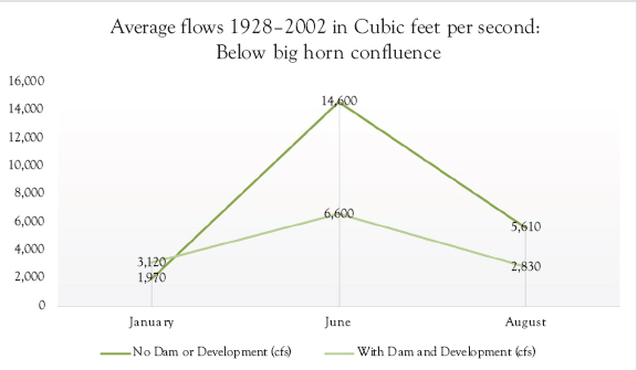
Figure 3.5 Comparing flows: With and without dam and development
It is also worth considering that the flood regime may have shifted because of climate change and that such changes may also directly and indirectly affect cottonwood recruitment. Some people in the valley claim that the June Rise is now most likely to occur in May. In fact, when comparing recent data to information gathered in the mid-20th century, in some locations the timing of spring flows is clearly in flux (U.S. Geological Survey 2005). In the upper Yellowstone River Valley, state officials predict three consequences of climate change: (1) earlier runoff, (2) faster runoff, and (3) diminished late-season flow (Dalby 2018). If seed production, pollination, and flooding are out of sequence, cottonwood recruitment is less likely. Field evidence from the upper basin near Gardiner and Livingston led modelers to conclude that the “small areas of forest established in the last 75–100 years suggested a decrease in river activity caused, at least in part, by a climate-induced decrease in peak flows” (Merigliano, Friedman, and Scott 2013, 162).
Despite the leveling effects of the dam, the Yellowstone River remains fairly flood dynamic as compared with other rivers. As recently as 2011 and 2017, many areas in the lower river flooded. Yet, there is little doubt that climate change and 60-some years of flood management in the lower valley has had an impact on the long-term well-being of the cottonwood forests. Using tree rings as evidence, researchers have compared the health of trees during the 1800s to the well-being of trees today:
The flow reconstructions revealed droughts and wet periods in the 1800s more extreme than any occurring in the historical record. Declines in growth at the Yellowstone and Powder Rivers beginning in the mid-to-late 1900s resulted partly from flow regulation, which delayed much of the runoff until after the early-summer period when most tree ring growth occurs. (Schook, Friedman, and Rathburn 2016, 1870)
In Chapter 1, we noted that it takes much work to understand the myriad factors and changes that might shift our calculations when attempting to manage forests for harvest. Similarly, we must continue to investigate a variety of questions, and to creatively explore ecologically grounded ideas, if we intend to address the long-term well-being of cottonwood forests. For instance, one study investigated whether changing flood and drought regimes created spatial problems in cottonwood regeneration (Nielsen et al. 2010). If male and female cottonwood trees had different tolerances to variation in water availability, the researchers reasoned, it was possible that spatial separations might emerge that would subsequently prevent seed germination. However, evidence of spatial segregations was not strong, and more recent evidence shows that among the oldest of cottonwood trees, male and female trees survive equally well (Friedman and Griffin 2017, 12, Figure 11). Thus, even though our investigations do not always prove our hypotheses, such studies are important. They are examples of the types of questions we will need to investigate as we endeavor to understand, and perhaps help ensure, the long-term well-being of the cottonwood forests.
It seems fair to question whether our current practices, left unchanged, will result in long-term environmental sustainability of the valley. The examples of the endangered Pallid Sturgeon and declining cottonwood forests illustrate that the impacts of human activities, including climate change, are linked to sustainability problems. The examples also illustrate that economic and environmental sustainability interests cannot be addressed in isolation from one another, and that any one remedy is unlikely to be wholly satisfactory. The ESA of 1973 functions to help ensure a more sustainable environment for certain species, but not without controversy and certainly not necessarily quickly. The Pallid Sturgeon was listed as an endangered species in 1990. Thirty years later, we are finally on the cusp of remediating one of the biggest obstacles to the long-term well-being of the Pallid Sturgeon, the blockage at Intake. As for cottonwood regeneration, it is unlikely that we will choose to remove Yellowtail Dam, and, thus, complete remedies are difficult to imagine. At the very least, we could work toward understanding flooding as an important natural process that we can value in terms of its positive consequences. Moreover, it may be that efforts to address dwindling Pallid Sturgeon populations and cottonwood forests can be linked. Perhaps, that which is good for the Pallid Sturgeon might also be good for the cottonwood trees. It will take creative thinkers to imagine how to address these issues, and it will require the engagement of many.
Discussion Questions
We might begin by pondering the long-term well-being of the Pallid Sturgeon:
1. In what ways does the Endangered Species Act of 1973 represent efforts of a previous generation to address long-term environmental sustainability for us?
2. Will the bypass channel, the alternative that was initially considered flawed, be adequate? How will we know? What if it does not work?
3. Should we continue to fund our federal and state hatcheries as a means of insuring the well-being of the Pallid Sturgeon as a species? Is this a sustainable approach?
4. What are some of the current factors, especially ones not thought of in 1990, that will affect whether the Pallid Sturgeon are sustained?
Assuming we care about cottonwood forests, we should think about these questions:
1. Do we need further scientific proof of the aging of the cottonwood forests along the Yellowstone River corridor? What kind of further data might be helpful?
2. If a sustained cottonwood population largely relies on conserving dynamic river processes, how might we ensure those processes?
3. If some of the factors leading to the decline of the cottonwood forests are global in scale, what might Montanans do locally?
How do residents’ comments concerning Pallid Sturgeon and cottonwood forests illustrate sensitivity to sustainability’s central question? If dozens of farmers leave “big patches of cottonwoods” or purposefully “plant wildflowers” near their fields, how many patches would it take to make a difference?
Easy Access Resources
Bureau of Reclamation, Record of Decision, 2016: www.usbr.gov/newsroom/newsroomold/newsrelease/detail.cfm?RecordID=57556
Endangered Species Act https://www.fws.gov/international/laws-treaties-agreements/us-conservation-laws/endangered-species-act.html
National Fish Hatchery at Garrison Dam: www.fws.gov/mountain-prairie/fisheries/garrisonDam_pdfs/Garrison%20Dam%20NFH_PallidSturgeonRecovery.pdf
Pick–Sloan Missouri Basin Program: www.usbr.gov/projects/index.php?id=380
U.S. Army Corps of Engineers, Missouri Recovery Plan: www.nwo.usace.army.mil/mrrp/efforts-actions/YS-Intake/
U.S. Fish and Wildlife, Revised Recovery Plan, 2014: www.pallidSturgeon.org/wp-content/uploads/2012/11/Pallid-Sturgeon-Recovery-Plan-First-Revision-signed-version-012914_3.pdf
Yellowstone River Cumulative Effects Analysis: http://ftp.geoinfo.msl.mt.gov/Documents/Projects/Yellowstone_River_Clearinghouse/Yellowstone-River-Cumulative-Effects-Study.pdf