
11. Travel & Navigation
Where do you want to go today? And how do you plan to get there? Apps that can answer those questions form the backbone of the utility of iOS. Navigation and travel apps help you find your way from point A to B to C by car (or see where you’ve been en route), and help you travel through the air—while coping with hassles on the ground.
INFORMATION / GPS NAVIGATION / TRACKING
TomTom U.S.A.

$39.99 • TomTom International • http://5str.us/zjz
The power of a standalone GPS mostly transferred into iOS
TomTom is one of the giants in navigation hardware, and it’s brought much of what made it a success there to its iOS app. Thoughtful changes were required to make it work on a smartphone.
Maps are included with the app, which boosts the size to over 1.3 GB. Each update to maps or program features requires a full download. But it’s convenient to have the maps built in: no network connection is required en route.

If you want traffic updates—indispensible information for anyone who commutes by car, as far as I’m concerned—you buy for a separate $19.99-per-year in-app upgrade. Updates are sent every three minutes. (Traffic does require data access and use, but it’s relatively minimal.)
TomTom offers a huge set of options for choosing a destination, including a Google search, Contacts, entering an address, and finding nearby points of interest (POIs), like gas stations, hotels, or parks.
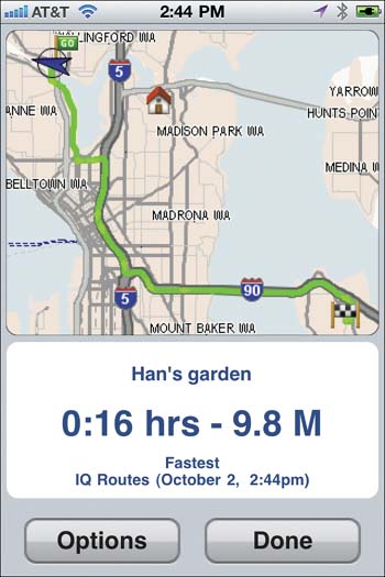
Navigation is presented quite well. By default, the map uses faux 3D (a flat 2D grid tipped to provide the feeling of distance). You can switch to 2D or see flat map representations of your map at any time. POIs are shown on the map, but you can choose which categories appear, including none at all. Spoken directions are generally clear, although the app really should know how to pronounce Los Angeles correctly (with a soft G, not the hard G of the Spanish original).
TomTom can work in the background under iOS 4 if you answer a call or switch to another app. With calls, navigation updates appear as on-screen push notifications. With another app, instructions are spoken while you’re using that foreground program.
More
TomTom sells several versions of its app by country. Check the App Store for particular versions. Traffic update service is a $19.99-per-year in-app purchase, which requires a free account to set up.
I pay a lot of consideration to how navigation apps interact with audio playback, as I’m often listening to music or a podcast in the car. TomTom lacks a built-in music player, found in some other programs. You can tap a musical note icon to pause and play music already selected in the iPod or other background audio app. Because of TomTom’s iOS 4 support, however, you can just swap to an audio program to make changes without interrupting navigation.
The app also allows a separate adjustment to control whether spoken directions fade back music or audio, reducing its volume, or pause playback while speaking. You can even adjust the volume of spoken directions. In other apps that lack this control, the navigator voice may blare out substantially louder than a podcast or music—it’s unnerving. The app can be set to speak numbers, streets, and traffic messages, or you can disable any or all.
The app also works with an external GPS kit for the original iPhone, iPhone 3G, 3GS, and, with an adapter, for the iPhone 4 ($99.95, http://5str.us/mtz).
A different kit is available for 2nd-generation and later iPod touch models ($79.95, http://5str.us/ddf). In testing, I didn’t find much of an advantage for the iPhone kit, but iPod touch owners will like the option of using GPS navigation without requiring a phone plan.
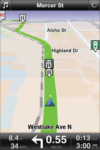
Navigon MobileNavigator

$49.99 • Navigon • http://5str.us/lvb
Clearer maps and better audio control
This app is an excellent alternative to TomTom, with different strengths. Its key weakness? Navigon lacks robust address selection; you can’t select from contacts, and address entry can be tedious.
But its navigation is top notch. The app presents streets and upcoming turns a bit better than TomTom, and shows retail and other POIs as a cleaner part of the landscape.
Navigon shines at audio support, with numerous options for controlling the interaction of spoken directions and music playback, including full iPod control within the app.
More
Navigon comes in many other editions, including ones specific to the U.S. west, central states, and east. Traffic update service is a $19.99-per-year in-app purchase.
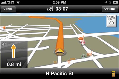
MotionX GPS Drive

$0.99* • MotionX • http://5str.us/ht5
An inexpensive way to get from point A to B without a loss of quality
MotionX seems to have a mission to charge the least for turn-by-turn GPS navigation software of any product on the market. Fortunately, the firm doesn’t forego quality in its drive for low cost.
It’s also a useful collection of other location and navigation features beyond turn-by-turn directions, including compass, position, and nearby search.
You start at the menu, where you can tap Search and then one of several icons for a quick result. Icons correspond to airports, gas stations, food, and parking, and there are links for manual entry and a search for locations as well. Instead, you can tap Go To in the menu, and select from over 15 links there, including Zip code and Contacts.
The Position feature reveals your current precise coordinates, heading, and speed. But it also lets you tap one of three buttons to save the position, make it your home location (which is often a lot of fuss in other apps), or a “Park Spot.” That last item adds your position to a parking spot list in the Go To menu.
The app doesn’t include maps within itself, which makes it a tiny download at 11 MB. However, this means all data has to be pulled down over the air, and that can rack up cellular data bills if you travel extensively. Traffic information is included, but it’s automatically figured into routes and not displayed as alerts.
The app does offer a simulation mode that can be run in advance of a trip to download and cache all the maps needed. The developers recommend running simulation at two times normal speed—it can run up to eight times faster—to have time to download all the necessary map pieces. You can set GPS Drive to hold up to 2 GB of cached map data, but you have to clear it out through an option in settings for fresher results.

MotionX is 99¢ for a 30-day trial of voice navigation. All other features remain active even if you don’t subscribe. It has among the best voice navigation, with the clearest tone and best pronounciation. Voice navigation is linked to an account, which can be available to multiple devices, but only be active on one device at a time.
Audio playback support is terrific: a full iPod controller is available for selecting music and podcasts with options just like the iPod app; a mini-controller handles playback, shuffle, and repeat.
Subscription
*After 30 days, voice navigation costs $2.99 for a 30-day subscription or $24.99 for a year.
AT&T Navigator

FREE* • AT&T • http://5str.us/6qo
Avoid traffic jams with this constantly updated subscription navigation aid
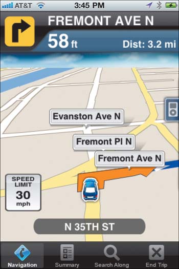
AT&T Navigator eschews features in favor of quality. Some competing navigation apps have the kitchen sink included, with dozens of preferences. But when you’re setting up a route and driving, simplicity is key.
Choose a destination from your contacts, by address, or by searching for business names or types, and go. AT&T Navigator is the best app I’ve tried (out of 14 that I tested) at consistently finding Contacts addresses, where even Google Maps has failed.
A voice navigation option is fairly remarkable but not perfect. You can speak street numbers and addresses, and the app works hard to match, but can’t always get it right. You can also speak searches for points of interest, like a gas station or coffeeshop.
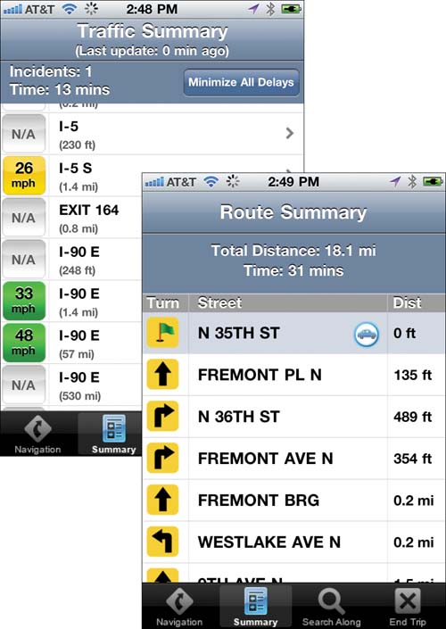
Traffic is part of the price of the monthly or yearly app subscription and is integrated within navigation. As you drive, you can tap Summary and select Traffic Summary to see what’s ahead, or tap Minimize All Delays to reroute around jams. A Maps & Traffic view also allows you to see current traffic conditions wherever you want, and to tap on alerts for more details without a route plan.
Directions and other information are spoken by a pleasant voice that sometimes sounds a bit spliced together.
Maps and traffic updates download as they’re required, and you need a cellular data or Wi-Fi connection to continue to view navigation if you vary from the planned route. This keeps the app compact and up to date, but can have an impact on your data bill.
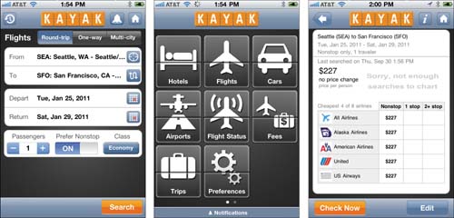
Kayak

FREE* • Kayak Software • http://5str.us/sn9
A shortcut to finding the best prices for flights, hotels, and more
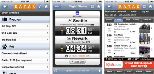
Kayak keeps it simple despite the pile of different features under its hood. While the app focuses on price comparison for air fares, hotels, and car rentals, it also offers plenty of information: airport details (via GateGuru, next page), flight status, airline fees, bag fees, price alerts, currency conversion, and a whole lot more.
For starters, you turn to Kayak to save money. The free app gives you quick access to price results at many different travel sites. Those results are organized by a travel plan (like a particular set of flights) that you use to choose at which site to book. That includes Kayak’s own booking service, if it’s available for a given itinerary. You can also set alerts for a flight plan to be notified if the price changes. You can set those updates to appear daily or weekly—on screen and/or via email—and pick a price threshold above which you’re notified.

The app’s Buzz tab lets you see at a glance what the current prices are—best and average—for a route across a month. This can help if you are flexible about the dates you want to fly.
More
Kayak First Class removes ads and searches premium fares ($0.99, http://5str.us/5ci). A free iPad app is also available (http://5str.us/v67).
ACCOUNT
*An optional free account syncs with Kayak.com.
The app also books hotels and cars, letting you specify locations and landmarks. For hotels, I like the division into choice (a combination of value and proximity), cheap, close, and classy; I may be classy, but my choice is cheap.
Kayak’s app links to an optional free account at the Web site to sync up trips you’ve noted or planned on the site.
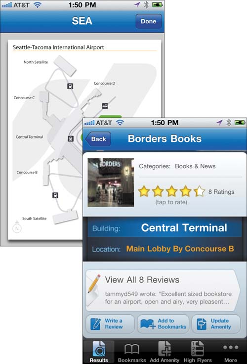
GateGuru

FREE* • Mobility Apps • http://5str.us/eji
Airport terminal information revealed and reviewed
Airline terminals seem designed to confuse, and perhaps they are. If we could see clearly how dreary it is waiting between flights maybe we’d fly less. GateGuru clears away the mist before our eyes, offering maps and amenity details for several dozen airports.
Airports are paired with information divided by terminals; if you don’t know which terminal you’re in (part of the airport’s design, sometimes), tap Entire Airport, and then tap Map in the upper right corner.
If you pick a specific terminal, you see the amenities offered, as well as special offers from restaurants and clubs. Each terminal’s detailed map is available, too. ATMs, restaurants, newsstands, bars, and other useful points of interest are paired with reviews left by GateGuru users. The reviews can be helpful in guiding you to a decent meal or an ATM without a huge surcharge.
EasyTrails GPS

$4.99 • Zirak • http://5str.us/iin
If you don’t know where you’ve been, how do you find it again?
If you hike, bike, stroll, or even drive paths regularly, you might want to stake out where you’ve been, and find out some information about the route, too. By foot or bike, tracking a trail lets you figure out distances and elevations for training or for tracking improvements.
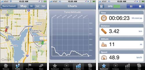
EasyTrails GPS, which requires an iOS device with a GPS receiver, can record a track as you traverse it, and provide live and archived details. Even its main screen is useful after it gets a good GPS fix (indicated by the number of green bars): the page shows your current altitude, speed, and coordinates.
Tap the Rec (record) button, and the app starts tracking points along your route. You can tap pause or stop buttons along the way, or tap the trash can to cancel and delete the current route. Information about the track is displayed as you go, including the current altitude, speed, distance, and time elapsed, as well as the average speed underway, and the current coordinates. This is useful for exploring a path—and deciding if you might be going too far!
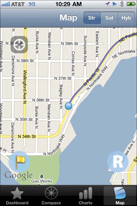
Three icons at the bottom provide alternate views: a compass shows the current heading; charts compare time, distance, and altitude; and the Map reveals the current route as recorded.

More
EasyTrails GPS Lite (free, http://5str.us/39y) tracks just one trail for 20 minutes but is otherwise identical.
Map view has two other useful options. Tap the flag icon and you can add a waypoint, a set of coordinates to which you attach a name and can add a photograph. This can be helpful when planning a run or trip, and you want to associate a place with a mile marker. You can also tap the big R button and pull up a previous track to follow.
When your route is complete, tap the stop button in the Dashboard view, name and describe the track (both optional), and tap Save. The Tracks tab now shows your latest outing. You can review that route on a map, and examine charts.
As a long-time cyclist, I appreciate the altitude charts that are generated. I’m always wondering about the elevation of a given ride, wanting to see both how hard it was and compare it to other rides. Often, these elevation profiles are found only in guide books. EasyTrails shows both the altitude over time and over distance.
Runners will like the time over distance chart that lets them track their average speed at mile marks, as well as elevation charts for seeing hill performance.
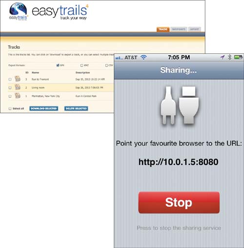
Tracks can be exported to EveryTrail. com, emailed (in one of several common formats, including GPS, KML/KMZ, and comma-separated text), or accessed over a local Wi-Fi network using a Web browser. The last choice I haven’t seen in other apps: you don’t need WebDAV (p. xvi); just fire up a browser. The app runs its own Web server.
The app places configuration options in the iOS Settings app; that’s where you choose units (feet/inches or meters), sound cues (when a GPS signal is lost or you’re near a set waypoint), and security for Wi-Fi sharing.
FlightTrack Pro

$9.99 • Mobiata • http://5str.us/rrp
Frequent air travelers can rely on knowing which gate to run to and when
FlightTrack Pro aids the regular traveler—or the spouse, partner, or parent of one. The app tracks flights you enter, both upcoming and current. It can download flights listed in a free or paid account at TripIt.com as well. (The sync is one way; flights added in the app don’t upload back to Tripit.com.)
Add flights in the app by tapping the plus sign on the home screen and selecting details. You can also shake the app and have a random current in-the-air flight added, useful for learning the app.
Active flights have a status screen that, when tapped, shows estimated and actual departure time, gate information, and stats about how likely the flight is to arrive on time. You can swipe down to add notes about the flight, call the airline, or find alternate flights.
Tap next to an airport’s name and the app shows you the latest FAA delay information and weather reports.
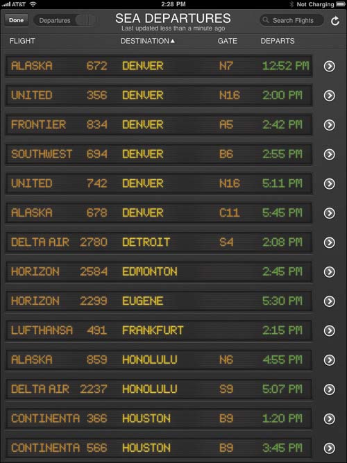
An in-app upgrade in the iPad version reveals a flight board when you search for and select an airport (shown above).
Flights added in the app can be placed on your calendar, and the app automatically updates details as they change. You can forward information about the flight over email and SMS, or via Twitter and Facebook.

More
The non-pro FightTrack omits TripIt sync, delay predictions, and push alerts for flights updates ($4.99, http://5str.us/g9s). FlightBoard offers just that display (universal, $3.99, http://5str.us/kt1).