© 2013 Sitephocus, LLC, www.sitephocus.com
Littlefield’s strategy proved successful. The city has attracted more than $3 billion in new manufacturing investment since 2008 and saw manufacturing employment rise by roughly 13 percent between 2010 and 2012.40 While this increase brought more traditional blue-collar jobs, it also brought more positions for engineers and others with strong technology backgrounds. Civic gains have proved equally important. Downtown has returned as a destination that draws people from every neighborhood and livelihood, and a notable arts district has begun to take form at its southern edge. A new art museum faces downtown from across the Tennessee River; the new waterfront offers children and adults the opportunity to splash in an urban river; and young adults crowd downtown bars and cafés. Intent on ensuring that every investment in downtown contributes to its energy and sense of place, Littlefield insisted that a pedestrian bridge linking walkable districts on both sides of the river also double as a work of public art. The result: a bridge paved with glass panels through which pedestrians can gaze down at the river 80 feet below.
Believing that public infrastructure could also be public art, the city worked with River City Company, a nonprofit developer, to encourage all new development to enhance the character of downtown. Architect and urban designer John Coddington became downtown’s de facto design manager, and the quality of new buildings and public realm alike suggest the high value accorded good design: they telegraph the civic, social, and cultural importance that downtown holds for the entire community. Waterhouse Pavilion, located at one of Chattanooga’s busiest intersections, demonstrates how this approach has paid off for the city. The brick-and-glass “public room” holds several hundred people and sits in Miller Plaza, a parklike square that incorporates an outdoor performance stage. Constantly filled with events and markets organized by community, arts, and other organizations from across the region—and a popular lunchtime destination for downtown workers—this distinctive public space symbolizes the integral role that downtown again plays in the life of the city and its region.
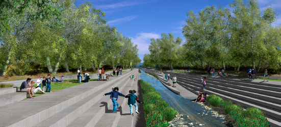
4.65 Chattanooga’s multidimensional approach to revitalizing downtown integrated highly visible initiatives, including a new waterfront and art museum; new housing that ranges from condominiums and townhouses to lofts in renovated downtown buildings; and support for the arts and entertainment, which has nurtured new galleries and other businesses and created a lively South Side arts district.
Courtesy Goody Clancy

4.66 a,b To emphasize the downtown’s role as the center for regional life, the city developed a highly innovative, and ultimately successful, strategy—creating a building whose sole purpose is to serve as a “public room.” The result is a civic space sought after not only for important regional meetings and public gatherings but also by neighborhood organizations and clubs of all sorts.
Courtesy Goody Clancy
Wichita
In October 2009, more than fifty civic leaders from the public, private, and nonprofit sectors of Wichita, Kansas, arrived in Chattanooga intent on studying how the city had achieved such dramatic changes in its downtown. Concerned about shifts in the regional economy and a growing income gap between the urban center and its suburbs, the Wichita Chamber of Commerce had five years earlier launched Visioneering, a freewheeling community conversation about the region’s future. The program had forged a broad consensus among public and private leaders about how the city and region should move forward together. The resultant plan yielded a commitment from private, public, and community leaders to work together toward downtown Wichita’s revitalization. One sign of community commitment: participants paid their own way for Visioneering field trips to Chattanooga and other cities.
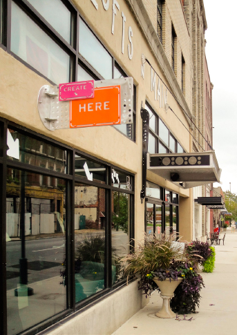
When the Visioneering initiative began, reviving downtown Wichita seemed unlikely. Following a familiar twentieth-century pattern, businesses, professional firms, restaurants, stores, and other businesses that had called downtown home up until the 1960s had largely decamped for the suburbs by 2009. One area flourished, however, even as the area around it continued to decline: Old Town. Twenty blocks of old warehouses and factory buildings had drawn little attention until the early 2000s, when a business owner noticed that the area around his restaurant had quietly developed a passionate following. Teaming up with an architect, he began buying and rehabbing older buildings, creating restaurants, entertainment venues, unique small businesses, two hotels, and, eventually, loft apartments. By the late 2000s, a growing Old Town supported flourishing nightlife, restaurant, and arts scenes. These amenities had in turn attracted several hundred urban pioneers to move to rehabbed lofts in the neighborhood.
These amenities also attracted the imagination of a group of engineers whom the manufacturer Airbus relocated to Wichita in 2008. Community leaders involved with Visioneering, including the mayor, took note: the engineers had insisted on locating their office in Old Town rather than in the suburbs. In 2009, Mayor Carl Brewer announced a partnership between the city and the Wichita Downtown Development Corporation (WDDC), a business-supported advocacy and management group, to produce a downtown master plan. The plan sought to unlock downtown’s ability to enhance quality of life, economic opportunity, and sustainability across the region, thereby boosting the region’s efforts to build a knowledge economy that could offset the decline of manufacturing.


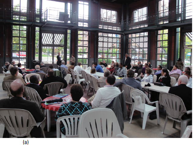
4.67 (a) Walkability stood as the critical goal for the Downtown Wichita Master Plan. A key strategy involved targeting new investment in housing, retail, offices, and hotels to reinforce vitality along priority walkable streets that connected a new arena, the convention center, Old Town, and other downtown destinations, (b) Downtown stakeholders supported concentrating private and public investment along these corridors for at least five years to reinforce all of downtown’s appeal as a live/work/play environment. Soon after the master plan’s approval, the city and county joined with a developer to redevelop a brownfield site that could not accommodate extended periods of occupation (such as housing or offices) as a shared parking facility (faced by a climbing wall) and a small park, (c) Together with housing and retail on adjacent surface parking lots, the development brought the area next to Old Town to life and strengthened walkable connections to nearby parts of downtown.
Courtesy Goody Clancy
The community-based planning process, run by the urban design firm Goody Clancy, produced information that surprised even downtown’s most enthusiastic advocates. A housing market study revealed demand for one thousand loft apartments across downtown over five to seven years—double the existing supply, located mainly around Old Town. A commercial market study revealed demand for nearly 700,000 square feet of upscale office space from a growing pool of mostly younger technology and design entrepreneurs, along with unexpected new demand for downtown hotel space. The analysis also suggested that a lack of suitable office space after decades of disinvestment had locked out some suburban employers interested in returning to downtown.
Downtown’s latent strengths became increasingly obvious during the planning process. Enthusiasm grew in proportion to confidence in market potential. The entire community rallied around a successful effort to maintain the state’s historic-preservation tax credit program, which legislators had proposed eliminating. Before plan completion, several developers announced new housing investment, and one of the region’s largest private employers decided to relocate a planned innovation center to downtown. In place of a signature project or urban design gesture, the plan called for multiple catalyst projects strategically located throughout downtown and programmed to bring a critical mass of new activity to walkable streets linking destinations like Old Town, a new sports arena, and a popular new park along the Arkansas River.
4.68 Wichita’s Old Town district had attracted several hundred residents to lofts, renovated from outmoded industrial buildings and warehouses, over the previous decade. The market study prepared for the master plan by team member Zimmeran/Volk revealed a demand for roughly two hundred new downtown units per year, suggesting that in five years Wichita could double its downtown population. In the two years since the master plan was enacted, the downtown’s residential population has grown by more than three hundred per year and is leading the way toward downtown revival.
Courtesy Goody Clancy
The year following the plan’s adoption brought announcements of a new boutique hotel; plans to rehab former office buildings for residential use; reuse of the historic Union Station complex for offices, stores, and housing; new restaurants; and other new investments. Old Town’s cachet has moved well beyond its original boundaries, and its trademark walkability has begun to spread as well. Much of this progress reflects the effectiveness of the partnership model the city and the WDDC have followed. The city has invested in infrastructure, revised zoning, built parking garages, and adopted policies to encourage development that ties together existing downtown destinations and Old Town, promotes walkability, and fills in gaps in the streetscape. The WDDC can recruit the developer best suited to a particular site or project, encourage high-quality design, and work to maintain enthusiasm and consensus about downtown’s ongoing revival.
Los Angeles
GIs returning to Los Angeles after World War II found a downtown that might well have served a twenty-first-century city. Union Station, opened in 1939, was the most modern major train station in America. Eleven hundred miles of streetcar lines fed into downtown from across the region. A growing population and a booming economy promised a bright future.
But in a step that made sense only in the postwar zeitgeist, Los Angeles cast its lot with the car. Intent on living up to its reputation as a city of the future, LA rushed to plan a vast freeway system and by 1950 was hard at work bulldozing those freeways through peripheral communities, opening orange groves and ranchland to development, and dramatically reshaping the region in just a few years. By the mid-1960s, even as the city’s population and economy grew rapidly, the streetcar lines had disappeared, Union Station had developed an unsavory reputation, and major employers had deserted downtown for affluent Beverly Hills and the rapidly developing San Fernando Valley. During the 1960s and ’70s, downtown took on a new role—as an entry point for hundreds of thousands of Mexican and Central American immigrants who brought a vibrant new culture as they settled into adjacent neighborhoods—that has helped shape its current revival.
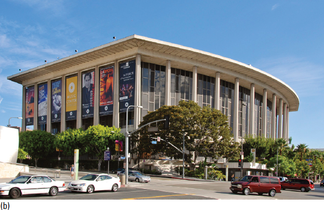
Beginning in the mid-1950s, the city began a string of investments and interventions in an effort to stem the outflow of employers and reverse downtown’s decline. Despite fierce opposition from a small band of preservationists, the redevelopment authority used its powers of eminent domain under urban renewal to level the historic Bunker Hill neighborhood on the western edge of downtown. New office towers rose on the rubble of Victorian mansions, consigning downtown to a nine-to-five business environment. Yet rather than drawing new employers, these sparkling towers hastened the decline of the other parts of downtown by luring tenants out of existing commercial buildings. Goaded by a business community convinced that continuing decline would hurt the region’s economy, the city sought to add cultural institutions as downtown anchors. It worked with private donors to create the Los Angeles Music Center, which opened in 1964 as the home of the Los Angeles Philharmonic and a marquee venue for performing arts, from Broadway shows to opera and ballet. Yet the high-profile complex produced little of the economic impact its planners had expected; for the most part, audiences drove in from the suburbs, enjoyed performances, and then climbed back into their cars and left without patronizing nearby restaurants or businesses.
The launch and expansion of the Metro subway system in the 1990s, together with burgeoning interest in downtown living, began to shift the balance in the area. New restaurants opened, artists and other urban pioneers trickled in to claim cheap space in vacant historic office buildings, and a booming Little Tokyo on the eastern edge of downtown began to attract tourists and other businesses. Hoping to build on this momentum, the city turned to large-scale attractions. In 1999, the Staples Arena opened (it now draws more than four million visitors annually), and business leaders raised more than $100 million to complete the Walt Disney Concert Hall, designed by Frank Gehry, which opened as part of the Music Center campus in 2003. In the early 2000s, the city and county began planning the Grand Park project, a 12-acre park with lawns, cafés, and performance spaces between the Music Center and City Hall.
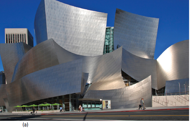
4.69 a,b Frank Gehry’s Walt Disney Concert Hall cost more than half a billion dollars (adjusted to 2013 value) and replaced the 1970s-era Dorothy Chandler Pavilion. It ranks alongside the Bilbao Guggenheim Art Museum as one of the most successful efforts to combine culture and spectacular architecture in order to recast a city’s image. It is not surprising that the city’s business community, early supporters of downtown revitalization, came to the rescue when the project stood on the brink of cancellation, contributing more than one-third of the final cost.
© 2013 Sitephocus, LLC, www.sitephocus.com
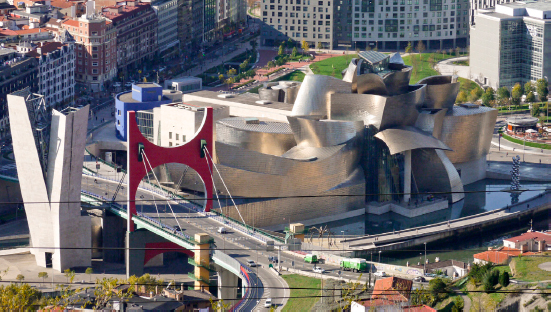
4.70 Commentators often call Frank Gehry the most important architect of his time (a Harvard Business Review writer, for example, flatly declares him “America’s most celebrated living architect”). Perhaps dazzled by his buildings’ forms, commentators tend to overlook his deep understanding of the urban landscape and how deftly he integrates architecture, open space, public space, and infrastructure in his work.
When Gehry’s Guggenheim Museum Bilbao appeared on the cover of the New York Times Magazine, coverage focused on the structure’s quality as an object. But the museum merits attention as much for its artful bridging of a highway that has divided Bilbao’s downtown from its riverfront and for its success as a symbol of twenty-first-century vitality that nevertheless respects the historic character and scale of the city around it.
Wikimedia user Xauxa (Hakan Svensson)
Architects and planners like Bill Roschen, FAIA, president of the LA’s planning commission, began to push for more comprehensive planning that linked these attractions to new housing and jobs. They argued for a more holistic approach to downtown as a distinctive environment that draws character from its simultaneous roles as a network of unique neighborhoods, a regional destination for entertainment, and a global business center. Most notably, this approach led to the creation of the Los Angeles River Revitalization Master Plan.
For most of its 48-mile length, including its entire passage through downtown, the river runs through concrete spillways that date to the 1940s and give it the appearance of an open sewer flanked by parking lots and industrial sites. Led by landscape architects Mia Lehrer + Associates and urban designers Civitas, the community-based planning process drew in residents of neighborhoods along the river. The master plan adopts a sophisticated approach to the redevelopment of an urban riverfront. It layers multiple missions—a neighborhood park for downtown residents, a setting for cafés and other attractions that will draw nonresidents, a spectacular venue for regional festivals—atop a sensitive understanding of ecological systems and their application as green infrastructure that can provide flood control and water-purification services at a far lower cost than if they were engineered.
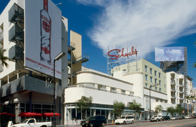
4.71 The Los Angeles Metro system spawned a transit-oriented housing boom. Less than ten years after it opened, the Hollywood station had spurred development of more than six thousand housing units. This new generation of higher-density housing stirred controversy in Hollywood neighborhoods that had witnessed little new investment for decades. Urban designer Bill Roschen, FAIA, was hired jointly by the city and a developer to work with the community and create a plan for “Hollywood and Vine,” a site that included the iconic Schwab’s lunch counter, where legend has it that Mervyn LeRoy discovered Lana Turner. Roschen’s work demonstrates that a new generation of mixed-use development could preserve—and breathe new life into—traditional Hollywood neighborhoods.
Courtesy Rochen Van Cleve Architects with Nakada + Partners; developed by Bond Companies

4.72 Known as a drag-racing site in the 1950s and ‘60s, the Los Angeles River has resembled an open sewer since it was encased in a concrete channel in the 1940s. Landscape architects Mia Lehrer + Associates and urban designers Civitas led a community-based planning process to transform the river into an amenity serving several new and revitalized downtown neighborhoods.
Courtesy Wikimedia user downtowngal
4.73 Los Angeles River Master Plan rendering.
Mia Lehrer + Associates Landscape Architecture
By the mid-2000s, housing had become a critical component of downtown development. But concerns shifted from attracting residents—whose number grew by more than 80 percent, to an estimated 52,000, between 2006 and 2013, despite the recession41—to finding ways to accommodate everyone, regardless of income level. In the fourth-most expensive housing market in the United States, the least expensive new market-rate housing required a household income of at least $75,000 per year—nearly five times the income of a full-time worker earning minimum wage. Los Angeles’s aggressive plan for affordable housing sought to harness some of the increase in economic value resulting from downtown development. But even though it promised to produce more new affordable housing units elsewhere in the city, tapping this value-added funding proved politically untenable. It threatened to transform downtown into a gated community that relied not on physical walls but on the intangible barriers of cost and income to keep all but the wealthiest residents out. To preserve a measure of diversity downtown, Mayor Antonio Villaraigosa secured city council approval in 2007 for a plan to tap rising housing values in a different way: the city would provide a 35 percent density bonus for downtown developments that made 15 percent of its on-site units affordable.42
The high-profile LA Live development—a $2.5 billion project with more than 5 million square feet of entertainment, hotels, offices and housing—has introduced a significant new level of density to downtown Los Angeles. Its density—conventionally measured by the ratio of total building square footage to the square footage of the building’s site (“FAR,” or floor area ratio)—of roughly 5.0 is not high for an older, East Coast city but surpasses that of the rest of downtown. LA Live fills several city blocks with a 24/7 live/work/play environment that feels as intense as New York’s Times Square. Its chaotic energy would violate the traditional spirit of most downtowns—and its commercial excess has offended many design critics—yet LA Live’s concentrated vitality offers a choice to people who seek an urban lifestyle that only a downtown can offer.
LA Live pushes Los Angeles’s downtown into a derelict district filled with low-intensity businesses like warehouses and truck distribution centers. Many U.S. downtowns abut at least one such district, often one contaminated by past industrial uses. These brownfields typically comprise large areas of vacant or underdeveloped land close to downtown but long ignored by the market. Their proximity to downtown and their low values make them well suited for moderate- to higher-density mixed-use development that responds to emerging markets. Taking advantage of these new markets, however, requires significant up-front investment, not just in environmental remediation but also in planning and new infrastructure. LA Live serves as a prime example: it depended on a robust public/private partnership that delivered early public infrastructure investment and a significant increase in permissible density to make relatively high development costs supportable.
The lofts, hotels, clubs, theaters, arenas, and convention center that make up LA Live constitute a new downtown district but have preserved little of the area’s industrial past. Redevelopment of old industrial districts elsewhere—in, for example, Tampa’s Ybor City, Cleveland’s Flats, Milwaukee’s Third Ward, and Denver’s LoDo—has reused historic warehouses and even anonymous single-story industrial buildings for lofts, performance venues, stores and restaurants, start-up offices, and other uses that now thrive in downtowns but don’t require traditional downtown environments. After declining over three decades as industry and warehousing left the banks of the Milwaukee River for suburban industrial parks and distribution centers, Milwaukee’s Third Ward emerged as an “arts and fashion district” in the 1990s. Construction of a continuous riverwalk connecting the river’s banks to downtown accelerated revitalization and development of residential lofts, locally owned restaurants and stores, music venues, and other uses reminiscent of LA Live. While LA Live asserts coolness through architecture, lighting, and public art that welcome the future, the Third Ward declares coolness by reclaiming a rough-edged past to create a defiantly anti-suburban present.
The emergence of resilience
Over the next twenty to thirty years, America’s coastal cities, along with a majority of the world’s major cities, will experience rising sea levels, while increased rainfall and flooding or prolonged droughts will affect virtually every part of the United States—and most of the rest of the habitable world. A number of American cities are transforming their urban landscapes as they take steps to become more resilient in the face of increased flooding and droughts. The Natural Resources Defense Council (NRDC) cites Philadelphia’s citywide stormwater management initiative as “the most ambitious green infrastructure plan in the country.” High-visibility structures like green roofs, new parks, porous pavement, planted medians, green swales, and rain gardens will replace approximately one-third of the impermeable surfaces in roughly 60 percent of the city, making a visible mark on these neighborhoods and lessening flooding citywide by eight billion gallons each year. Faced with eight years of drought, Denver is changing its urban landscape, but in a very different direction. Xeriscaping—landscapes that require very little water and are more familiar in desert cities like Phoenix—is replacing acres of green lawns and lush planting as the city adapts to the reality of a more arid climate.
Meanwhile, escalating concern about the combined impacts of increasingly intense, increasingly frequent storms and rising sea levels has begun to spur visible change, particularly along America’s East Coast, which appears destined to experience the country’s most dramatic climate-change impacts. New York City has taken the most significant steps. Just eight months after Hurricane Sandy slammed into the city in October 2012, Mayor Michael Bloomberg’s administration released A Stronger, More Resilient New York, a blueprint for helping the city defend against and rebound from similar storms.
The press greeted the plan as a groundbreaking attempt to plan a major city’s adaptation to rising sea levels. The plan drew, however, on a long tradition of living with water pioneered by the Dutch. As early as 1400, much of the Netherlands was protected by a system of dikes and canals. Today, more than ten million people—in a country with one of Europe’s healthiest economies—live below sea level, protected by a complex system of dikes designed to hold back rising seas and rivers, barrier islands to slow the force of storms, floodgates to close off rivers to surging sea waters, wetlands, and other natural and engineered defenses.
The experience in the Netherlands offers three lessons that inform every dimension of A Stronger, More Resilient New York. First, “don’t retreat”—the understanding that the human and economic value of cities is too great to abandon them in the face of turbulent seas and the belief that human ingenuity is up to the task of creating new defense methods. Second, celebrate your community’s relationship to water. Third, treat every investment in resilience as an investment in community-building that can provide human and economic value in addition to protection.
New Orleans’s experience in the aftermath of Hurricane Katrina taught Americans the first two of these lessons. As discussed in chapter 3, the controversy surrounding the rebuilding of New Orleans East demonstrated that retreat is neither desirable nor realistic for most cities. In a different way, New Orleans’s experience demonstrated the value of celebrating water rather than viewing it strictly as a threat. For years, New Orleans had covered the canals that shunted stormwater to the pumps that forced it into Lake Borgne. Covering the canals removed what most residents considered an unsightly bit of infrastructure (and a reminder of the city’s vulnerability), but it also severely reduced their capacity to handle large volumes of water, and they repeatedly failed to perform during flooding.
Dutch experts, invited to help the city’s recovery planning by architect David Wagoner, FAIA, and the American Planning Association, brought with them a very different sensibility. They worked with a broad cross-section of residents to develop a vision of a city that embraced water: the creation of a “blue signature” of canals that, with interconnected rain gardens and swales, would introduce a greatly enhanced system for absorbing heavy rains and holding stormwater until it could be pumped out.
The third lesson from the Dutch will prove the most significant for urban design over the coming decades. In an era of scarce public resources and growing demand for urban development and infrastructure, every dollar invested in resilience should also be a dollar invested in community-building. Until the second half of the twentieth century, the Dutch resisted and fought flooding—building more, ever-stronger dikes and other protections whose sole purpose was to hold back storm-driven flooding. While effective, this approach grew increasingly costly and offered only a “passive” long-term return—lives and money saved when damage did not occur.
But in recent decades, the Dutch have shifted to a more nuanced approach, permitting flooding in areas that can tolerate it; mixing protection with the adaptation of buildings and land uses to enable other areas to experience limited, periodic flooding without significant damage; and—most important for urban design—creating a mix of natural and engineered protections that also improve quality of life. One very visible benefit: these strategies leverage the high real estate and recreational value of waterfronts to provide a near-term flow of financial and social benefits in addition to the longer-term benefits of lives and dollars saved. Barrier islands and man-made dunes that absorb the force of wind-driven waves (which can more than double the height of flooding associated with ocean storms) take the form of public beaches and even sea resorts. Seawalls become foundations to support a new generation of growth for historic downtowns. A polder—an area reclaimed from the sea with a system of dikes—built to protect its neighboring region also functions as a new smart-growth, transit-served suburban center called Almere, located a few kilometers from Amsterdam.
A Stronger, More Resilient New York applies all three lessons. First, Bloomberg himself called for investing roughly $20 billion to protect flood-prone parts of New York City. Second, the plan uses resilience measures to expand beaches and introduce sand dunes on Staten Island and in Queens; creates a major new waterfront park on Staten Island; and offers financial incentives for building owners to invest in making threatened buildings safer in the event of future storms instead of abandoning them. Third, rather than pull back from vulnerable areas that now house 400,000 people and 70,000 buildings, the mayor seeks to increase both numbers. He proposes developing a major new mixed-use neighborhood—Seaport City—on the scale of Battery Park City to protect Lower Manhattan, one of New York’s most vulnerable areas and one that suffered significant damage from Hurricane Sandy. The plan advocates using landfill that extends out to the pier line as a seawall to protect Lower Manhattan and create a platform for a new neighborhood that will attract billions of dollars in mixed-use investment.
Since the early 1970s, governors, mayors, developers and Columbia University’s Center for Urban Real Estate had all proposed landfill-based projects for the area, ranging from a museum designed by Frank Gehry to more than 80 million square feet of mixed-use development (termed “LoLo” for “Lower Lower Manhattan”). The Seaport City proposal, however, relies on a different logic, one that makes it a compelling model for other cities. As Vishaan Chakrabarti, director of Columbia’s Center for Urban Real Estate (and author of the LoLo proposal) points out, “Instead of . . . running from the waterfront, we need to protect it.” Tapping the significant real estate premiums offered by waterfront environments can pay for the costs of protecting the waterfront and the adjacent city. Seaport City offers two other opportunities to leverage investment in resilience. First, these dollars can create a lively addition to Manhattan’s public waterfront—promenades and parks inspired by the vitality of twenty-first-century urban renaissance and animated by food, entertainment, art, and culture. Second, the neighborhood itself can accommodate millions of square feet of housing, offices, hotels, and other activities that take advantage of excellent transit infrastructure and invigorate Manhattan without intruding into established neighborhoods defined by their traditional scale and character.
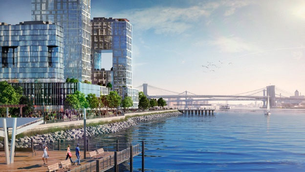
4.88 In response to Hurricane Sandy, Mayor Michael Bloomberg’s administration issued a $20 billion plan to make New York City more resilient in the face of rising sea levels. Its signature urban-design proposal: Instead of retreating from its waterfront, the city could build an entirely new neighborhood that doubles as a protective seawall along the East River. Tapping the high value of waterfront development, high-density, mixed-use Seaport City could help fund resilience.
NYC Mayor’s Office, Special Initiative for Rebuilding and Resiliency
Proposals like Seagate signal another role for resilience planning—providing an opportunity for urban designers, landscape architects, ecologists, and others to reevaluate environmental regulations that date largely from the 1970s and were developed to fight the battles of that era. Some of these regulations constrain innovative urban development today in ways that benefit neither the environment nor cities. Ironically, constraining intense development along urban waterfronts can reduce a city’s ability to become more resilient. Urban designer Stan Eckstut, FAIA, who prepared the master plan for Battery Park City, points out that cities like New York will need to revise key environmental regulations. He notes that “ever since Battery Park City, you basically can’t do landfills in America anymore. . . . But the mayor’s idea is exactly right, and it’s something that has been desirable from lower Manhattan’s perspective for a long time.”43
Four thousand miles to the east, Hamburg, Germany, began to develop a prototype for its own “Seaport City” more than a decade ago. Faced with the task of retreating from the impact of global warming to the perceived safety of its seawall, Hamburg decided instead to build a new downtown quarter lining the waterfront outside of the seawall and planned and designed to flourish in an era of intensifying storms and flooding. When completed in another decade, the result, HafenCity, will accommodate roughly 12,000 residents, 45,000 jobs, and 4 to 5 million square feet of retail, food, entertainment, arts and culture, and education, together with roughly 6 miles of continuous waterfront that will include more than 60 acres of lively squares, quiet parks, floating platforms, interactive public art, and unique public spaces that celebrate Hamburg’s history as a port.
By seizing the opportunity to make significant investments in its waterfront that adapt to rising sea levels, Hamburg will leverage its most valuable asset—its dramatic waterfront—to create economic, cultural, and social value. HafenCity provides the historic downtown with new jobs, cultural venues, retail, and other traditional downtown activities. Of particular interest, employers seeking large, modern floor plates unavailable in the historic center and a monumental new performing arts center too large for the historic center can both locate downtown rather than in underdeveloped parts of the region.
HafenCity’s waterfront location offers value premiums that fund a complex system of floating platforms, waterfront esplanades, midlevel walkways, and higher-elevation streets that will make the new quarter feel open and inviting yet capable of withstanding 30-foot waves and wind-driven flooding. These economic premiums also help underwrite the cost of an amenity-rich public realm enlivened by food, entertainment, and culture that is expected to draw more than 16 million visitors per year to HafenCity—and to the heart of Hamburg as well. The quarter is also a unique residential neighborhood in which most housing will overlook the harbor, creating a destination for affluent young professionals and empty nesters that will help fund significant affordable housing to ensure that HafenCity contributes to Hamburg’s commitment to embrace its growing diversity.
More than seven hundred architects thus far have created a mix of bold—and in some cases iconoclastic—buildings that proclaim cutting-edge design values and offer Hamburg an opportunity to express its twenty-first-century vitality in a way not possible in its historic center. At the same time, the plan strives to maintain physical and social continuity. Block sizes are smaller than those in extensions of the historic center developed in the nineteenth century in order to preserve the center’s rhythm and variety. Connecting streets are lined with stores, restaurants, and cafés to ensure continuous pedestrian interest. In a notable departure from many current practices, the plan does not gather corporate buildings with larger floor plates close to one another or in a dedicated precinct (as is the case in La Défense in Paris or Pudong in Shanghai) but instead mixes them among buildings of very different scales and uses to avoid, in the words of Jürgen Bruns-Berentelg, CEO of HafenCity Hamburg GmbH, “non–Jane Jacobs spaces.”
The concept of resilience is shaping cities in other ways. At a January 2013 conference sponsored by the Land Use Law Center at Pace University School of Law, economist Arthur C. Nelson predicted that gas will sell for $16 a gallon by 2030, a sign of increasingly prohibitive energy costs. Also inspired by environmental responsibility, a number of developers have begun to experiment with self-sufficient “net zero” cities that produce all of the energy they require. A sign of growing interest in this approach, the first annual Net Zero Cities Symposium took place in October 2012.
The most ambitious initiative to date is Masdar City in Abu Dhabi (see case study, p. 204), a city of 50,000 residents and 60,000 workers scheduled to be complete by 2025. Masdar City’s extensive mass transit system (including trial Personal Rapid Transit technology), futuristic energy-efficient architecture, walkable density, and narrow, car-free, shaded streets contribute to achieving its net zero goal. While some of the transportation and other anticipated energy-saving technology has proven too expensive, and net zero remains an elusive goal, Masdar City is the most advanced city-scale model to date for planning and designing for energy self-sufficiency.
Like similar projects, such as Babcock Ranch in Southwest Florida, Masdar City could only be built from scratch; the cost of retrofitting existing urban environments is prohibitive and will likely remain so for the foreseeable future. New energy-efficient cities, even if they attain net-zero status, pose serious challenges to the concept of sustainability. They encourage greenfield development, require substantial investments in new infrastructure, and compete with existing cities for jobs and residents. The very high costs of building a de novo city could also pose very real challenges to promoting social and economic diversity.
The Costs of Success
Social equity
American society has become less equitable over the past decades. In 2012, more poor people lived in suburbs than in cities for the first time, and the distance between high- and low-income households has reached levels not matched since before the Great Depression. New Orleans offers an example of the complexities and challenges of mitigating inequality. One of America’s poorest cities in the 1990s, New Orleans had begun to recover for the same reasons other walkable, historic cities began to revive: the mix of historic character, living culture, and walkability that its inner-city neighborhoods offer—a mix essential to remaining competitive. When Hurricane Katrina devastated the city, however, New Orleans still had the reputation, and self-image, of a declining city steadily losing investment and people to its suburbs. The recovery effort brought new opportunities to New Orleans and to its poorest residents, who were largely African American.
The Housing Authority of New Orleans (HANO) decided to use the recovery effort to rebuild its entire public housing portfolio while reducing the number of low-income housing units. Many former residents of the city’s public housing developments, evactuated after the hurricane but too poor to return without a guarantee of long-term housing—did not come back. Lower-income refugees from the storm resettled in cities like Houston and Atlanta, where they found better jobs and public schools. In the first years after the storm, New Orleans’s population shifted from a black to a white plurality. The implications of that transition became apparent as a semblance of normalcy returned to the city. The gentrification that had occurred in many older cities now began playing out in New Orleans’s older inner neighborhoods as housing costs escalated and developers transformed empty industrial buildings into lofts that rented as quickly as they hit the market.
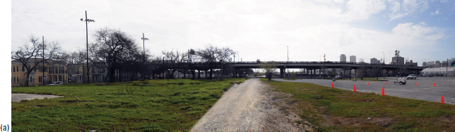
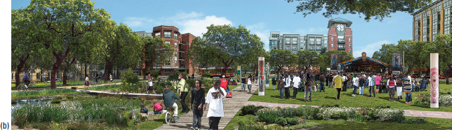
In 2012, New Orleans launched the Livable Claiborne Communities (LCC) Study (led by Kittelson Associates and Goody Clancy) to assess the costs and benefits of removing the Claiborne viaduct—an elevated expressway whose construction in the 1960s cut off Treme and other African American neighborhoods from downtown. While removing the viaduct raised difficult regional transportation issues, it offered a tantalizing array of possible urban design benefits, including a chance to restore Claiborne Avenue as a lively, mixed-use Main Street that served rich and poor neighborhoods alike; reconnect a series of historic neighborhoods to downtown; and remove a major obstacle to investment around the heart of the city’s healthcare economy (including $2 billion in new hospitals built after the storm). However, removing the viaduct might also accelerate gentrification, which threatened to dislocate households whose families had lived in the neighborhoods along Claiborne Avenue for generations. Controversy dogged community meetings about the plan, as many community leaders acknowledged the viaduct’s negative impacts but argued for keeping it in place to avoid upward pressure on housing costs.
New Orleans’s director of place-based planning, William Gilchrist, FAIA (who in a previous role had championed Railroad Park in Birmingham, Alabama, described below) determined that the LCC study should focus on keeping the community intact, and only then assess the feasibility of removing the viaduct. The study recommended a comprehensive initiative—with or without removal of the viaduct—to transform the existing neighborhoods into mixed-income communities in which current residents benefited from new investment in revitalization. Their neighborhoods would add 15,000 to 20,000 new housing units over twenty years—many refilling vacant lots left from decades of economic decline and Hurricane Katrina’s destruction. Crucially, half of these housing units would be made available to households that fit the economic profile of existing residents, an amount sufficient to accommodate all current households in rental housing that might face displacement by redevelopment. The study also tied billions of dollars of anticipated investment to funding programs to prepare residents for better-paying jobs and to support the indigenous neighborhood cultural life that serves as the backbone of the neighborhoods’ social networks and safety nets—including crafts such as intricate beadwork, traditional organizations such as Mardi Gras Indians, and the musicians who lead second lines.
Courtesy Goody Clancy
Ganesh Ramachandran rendering courtesy Goody Clancy
4.92 (a) In response to community concerns that tearing down the elevated Claiborne Expressway (initially intended in part to “protect” downtown from African American neighborhoods like Treme) would displace long-term residents, (b) a city-led study recommended that half of all new housing (projected at more than 15,000 units over twenty years) be affordable—enough to ensure that current residents living in below-market rental units could find affordable housing.
Ghost urbanism
The healthy optimism expressed in this chapter requires some counterbalancing words of caution. Empty suburban houses, condominium towers, office buildings, and shopping malls, many built shortly before the onset of the Great Recession in 2007, offer a bitter reminder of the cyclical nature of real estate markets. Much of this vacancy stemmed from the rapid shift away from suburban markets. But the same “innovative” financing that triggered an economic collapse had previously fueled an irrational boom, with substantial overbuilding in both urban and suburban areas. Many of the European countries struggling to recover from the collapse of the credit bubble display the ruinous results of this overbuilding. In the Valencia region of Spain, for example, a gleaming new €150 million airport failed to attract a single commercial airline. The city of Valencia’s new cultural center, designed by Santiago Calatrava and intended to put the city on the map, failed to attract visitors, while the region’s unemployment soared to almost 30 percent. Empty residential towers dot Madrid’s satellite cities. In Ireland, excess building has resulted in the demolition of new homes and buildings that were falling into decay; even though practically new, they were actually viewed as blight. Even rapidly urbanizing China, which seeks to relocate 240 million rural dwellers to cities by 2035, has thousands of empty housing towers built on confidence rather than market data.
Balancing Individual and Community: The Public Realm
“Are white Americans unusually individualistic?” asked The Economist’s political blogger “Lexington” in 2013. Lexington pointed to a study showing that white male college students reported less interest than female students or students of color in a course whose subject matter offers benefits to society rather than the individual taking the course.44 The results appear to support the argument that many aspects of American life—from a preference for suburbs to concerns about the role of government—stem from a deeply ingrained streak of individuality. Crediting the blandness of America’s urban squares to a lack of interest in shared public life, the urban designer Alex Krieger has quipped that “if we want to re-create lively European squares, we need to import lively Europeans.”45 Some trace this streak to America’s frontier heritage; others see it in the independent spirit that propelled tens of millions of immigrants to cross oceans to build a better life.
Neither explanation is fully convincing: relatively few Americans descend from frontier families, and immigrants typically settle into tight-knit communities with a strong sense of communal responsibility and culture. The answer may prove much simpler. Just as during the Great Depression Americans embraced the New Deal and its emphasis on interdependence and community, the explosive rise of a large new middle class after World War II allowed tens of millions of Americans to flee the urban neighborhood life they associated with poverty for a new life in the suburbs that celebrated their individual achievement.
The rediscovery of community by the children of first-generation suburbanites seeking an alternative to “white-bread environments” has fueled a renewed interest in shared community that will prove central to shaping twenty-first-century neighborhoods. While this revival takes many forms, three stand out for their impact on urbanism today: a growing desire to share a public realm that helps break down social isolation and celebrate community; a growing awareness that technology appears capable of bringing people together in previously unimagined ways; and a growing awareness of the moral, political, and economic costs of ignoring social inequity.
Writing in the architectural journal Places, the architect Hugh Hardy noted that “[Architect] Charles Moore’s observation nearly forty years ago that the best new American public space was Disneyland, and that you have to pay to use it, seemed prophetic to many of us at the time. But now I think that Moore was onto something else: American public space is evolving, not evaporating.”46 That evolution has continued into the early twenty-first century. Disneyland does not represent a new model for public realm in part because Americans ask for—and increasingly the public sector delivers—public places that are both engaging and truly public.
In recent years, two trends have converged to elevate the role of the public realm in urban design. The renewed embrace of urban living stems in significant part from an appetite for the sense of community that Americans have historically found along Main Streets and in urban squares and public parks. At the same time, surveys show that Americans today not only accept diversity, they seek it out. As noted in chapter 3, Americans also appear far more interested in living in diverse neighborhoods and working in diverse companies than at any time in this country’s history. They mourn the loss of community that their parents and grandparents tell them once flourished in churches, union halls, and schools that served the homogenous neighborhoods of the first half of the twentieth century, yet today no one would accept the idea of a neighborhood in which everyone shares the same religion, jobs, or stage in life. The public realm has evolved because expectations for how it looks and functions have evolved; Americans today demand that it deliver something new—community experiences created out of diversity.
The expectation of diversity surfaced in 2010 focus groups comprising mainly well-educated, white professionals under the age of forty, assembled during planning for a new higher-density, walkable downtown in suburban Dublin, Ohio. Participants noted that they wanted to live in “social places” and not have to drive to find them. One attendee asserted that “you can find apartments for the same rent in Chicago and Dublin—but you get a lot more in Chicago.” He clarified his comment, noting that “obviously, you get more space in Dublin, but you get life outside your door in Chicago.” These same focus group members repeatedly underscored the importance of diversity: a homogenous community, they said, “doesn’t feel real.”47
Although most focus-group participants did not want to leave Dublin, they clearly wanted the suburb to change: they wanted lively, walkable streets and squares, and they wanted a central park. They did not want new public spaces to reflect “conventional programming and design.” Instead, they desired a new generation of public realm that would not just draw residents together but promote socializing and introduce new opportunities for spontaneous interaction—in the words of the Dutch writer Wilfried Hou Je Bek, they wanted to see places that respond to an “active search for, and celebration of, chance and coincidence.”48 Hou Je Bek evokes the spirit of psychogeography, an approach to urban public spaces that the writer Joseph Hart describes as advocating “a whole toy box full of playful, inventive strategies . . . just about anything that takes pedestrians . . . and jolts them into a new awareness of the urban landscape” and each other.49
Gardens of delight: Millennium Park (Chicago) and the High Line (New York City)
This new sensibility has imbued even the most traditional types of public spaces—signature urban parks—with a new vitality and originality. The most discussed and visited recent American parks— Millennium Park in Chicago and the High Line in New York—each functions more as a garden than a conventional park. Each includes noteworthy and beautiful traditional landscaping that tells a story about its setting’s ecology. And each draws millions of visitors annually for the unique and engaging experiences it offers. Millennium Park is a latter-day, consciously urban Tivoli Gardens (Copenhagen’s “pleasure garden,” opened in 1843) that juxtaposes fantastical, interactive sculpture and fountains, jubilant architecture, live-performance spaces, whimsical public art, and other artful follies that constantly startle and delight.
The High Line represents a new conception of a downtown park that passes above the city rather than sitting within it. Conceived of and assiduously promoted by residents Joshua David and Robert Hammond and designed by a large team led by landscape architect James Corner, the linear park snakes for twenty-five blocks through Manhattan’s Chelsea neighborhood on the bed of an abandoned elevated railroad line. It offers views of the ever-changing street scene below it, providing a way to interact with the city itself that is every bit as kinetic as Millennium Park’s more tangible delights.50
A neighborhood living room: Pearl District Parks, Portland, Oregon
The 1999 plan for Portland, Oregon’s Pearl District is a conscious effort to use parks to create a sense of community for a highly diverse urban neighborhood. These parks break “community” into its constituent parts on a spectrum that moves from neighborhood-wide events to personal interaction. The North Park Blocks offer basketball courts, host a holiday parade and seasonal art fairs, and invite residents from across the region to enjoy Portland’s International Beer Festival. A few blocks away, Jamison Square includes a fountain-fed basin that one parent described on Yelp as “happy madness”—a place that invites kids of all ages to play while their parents and friends hang out and meet each other.
Tanner Springs Park offers a quieter, more personal experience. Herbert Dreiseitl, whose firm completed the design with GreenWorks PC, describes the park as a site where “the urban skin of one downtown block is peeled back” to reveal underlying wetlands. The park presents opportunities to touch, wade into, and play in water that seems a natural feature of the site (but is in fact designed and engineered) and to sit and contemplate the natural substrate beneath the Pearl’s (and, by extension, the city’s) urban landscape.
Common ground: Railroad Park, Birmingham, Alabama
Birmingham, Alabama’s Railroad Park opened in 2010 and takes a further step toward creating community, consciously forging common ground for a city long divided by race. Known as the scene of racial clashes that defined the civil rights movement of the 1960s, Birmingham today seeks recognition of its conscious effort to build a new sense of shared community across racial lines (few American cities devote as much public discussion to issues of race and class as Birmingham). The city has also struggled with the stresses facing other former industrial centers. Its downtown’s decline parallels the decline of a substantial industrial economy—the city once went by the nickname the “Pittsburgh of the South”—and the departure of middle-class residents of both races for the suburbs. A final blow came after a decade of bank consolidations ended the city’s status as a regional financial center. At the same time, the University of Alabama Birmingham (UAB) campus—cut off from downtown by a railroad line—flourished as downtown shrank.
The city’s planner, William Gilchrist, FAIA, saw the opportunity to transform abandoned industrial sites along the railroad right-of-way into a park that could reconnect suburbs and downtown, white Birmingham and black Birmingham, UAB and downtown. Gilchrist asked landscape architect Tom Leader to “design a great park but create a better common ground.” The design process conveys the complexity of designing for community. “[W]e started over ten times, and each time we learned, as different kinds of people joined the process,” said Cheryl Morgan, the head of Auburn University’s Urban Studio, who helped facilitate active community engagement throughout the design process. “In the end, this kind of engagement paid off because all these people now feel Railroad Park is theirs.” When an Urban Land Institute jury visited the park in 2012, members reported finding people of all races and ages jogging, holding community potlucks, exercising, lying in pairs in the sun, charging in small groups along a narrow stream, and sharing tables at the food pavilion. A potluck organizer told the visiting jury, “This is the first time suburban neighborhoods have had a place to gather downtown. . . . I know at one point the committee rejected an offer of $5 million to build a fancy restaurant. . . . I think they were right—potlucks are a much better idea.”
Claiming city streets as public places
Recognition that public streets should support more functions than simply moving vehicles first emerged in Oregon as an outgrowth of the environmental movement of the late 1960s. In 1971, the state legislature passed a bill requiring local governments to accommodate pedestrians and bicyclists on new and substantially rebuilt roadways.51 Over the next three decades, the rules that guide the planning and design of streets nationally began to give increasing priority to the needs of all users, including pedestrians, bicyclists, and transit riders. Most recently, the paradigm for urban streets has added a new dimension: support for community gatherings traditionally associated with urban squares or public parks.
In 1981, the urban designer Donald Appleyard published the landmark Livable Streets, in which he made the case that planning and designing streets to reduce traffic and invite more pedestrian activity significantly enhanced neighborhood livability and sense of community.52 In the late 1980s, New Urbanists began to argue that neighborhood character should take precedence over moving traffic efficiently, a principle that translated into reducing streets widths, accommodating curbside parking, and designing intersections for pedestrian convenience rather than around such criteria as the turning radii of trucks.53 In 1996 the Maryland Department of Transportation hired an urban planner, Yolanda Takesian, to help it reorient transportation investments toward enhanced community character, quality of life, and economic competitiveness. Takesian helped introduce the concept of “context-sensitive design,” which emphasizes the importance of placemaking and qualities like “walkable communities” to guide the design and funding of roadway improvements.54 In 2001, West Hollywood, California, approved a plan that represented a significant next step in this evolution. It assigned its major public street, Santa Monica Boulevard, dual responsibility as the city’s main traffic artery and its central park. It created a series of small parks out of underutilized right-of-ways and sidewalks and converted a landscaped median to a pedestrian promenade. The city closes the boulevard to traffic periodically for community-wide events and celebrations.
By the late 2000s, many cities and states had inaugurated “Complete Streets” initiatives focused on redesigning streets for multiple users, including pedestrians, bicyclists, and transit users, as well as automobile users. For example, noting that streets represent 56 percent of city-owned land and “define the character of Boston’s neighborhoods,” the city’s transportation department issued Complete Streets design guidelines in 2013. In Mayor Thomas Menino’s words, this comprehensive and highly detailed document aimed to “rebalance our streets so that walking, cycling, and transit are as safe and convenient as driving a car.” In effect, the city declared a break with policies designed to maximize street capacity for motor vehicles, policies in place since the advent of widespread auto ownership in the late 1920s. Henceforth, it would plan and redesign streets to improve their ability to fulfill multiple roles—only one of which would be carrying traffic.55
Meanwhile, in 2009 the New York City Department of Transportation, led by Janette Sadik-Khan, took West Hollywood’s plan for a Santa Monica Boulevard a step further. Facing traffic congestion and pedestrian gridlock in Times Square, the city launched “Broadway Boulevard,” an intervention that claimed varying portions of the traffic right-of-way exclusively for pedestrians and created a sort of linear park dotted with tables, umbrellas, chairs, food vendors, performers, temporary public art, bike lanes, and other amenities. The popularity of the change prompted its expansion to include two miles of Broadway. (Even some drivers admitted that it improved traffic flow, despite widespread fear that it would worsen traffic congestion before its implementation.) The park fluctuates, expanding at Times and Herald squares on weekends or for festivals and sometimes closing sections of Broadway to vehicular traffic entirely. The city quantified the results of the change—a step that many more urban design initiatives should undertake—and determined that injuries to auto occupants fell by more than 60 percent and pedestrian injuries dropped 35 percent; bike ridership rose significantly; pedestrian traffic volumes increased, and pedestrians spent more time in the area, benefiting nearby businesses.56 A Manhattan architect rendered a positive verdict in anecdotal terms: “I never thought in my lifetime that New Yorkers would be hanging out together on Broadway.”57
Noting that “more than 25 percent of the city of San Francisco consists of streets—a far larger share than parks,” the city’s planning commissioner, John Rahaim, describes San Francisco’s Pavement2Parks initiative as “a citywide laboratory in which all kinds of people are helping us figure out what to do with all the wasted pavement we have in our city, the legacy of decades when we sized our street network the way shopping centers size their parking lots—for the equivalent of demand on the day before Christmas.”59 Businesses, neighborhood organizations, artists, and other sponsors have built more than one hundred temporary “parklets” and plazas (with four hundred more proposals in the pipeline). The smallest of these installations transform parking spaces into anything from outdoor lounges to cafés to interactive public art; the largest claim portions of streets as temporary plazas with tables, chairs, musicians, and a constantly changing roster of attractions.
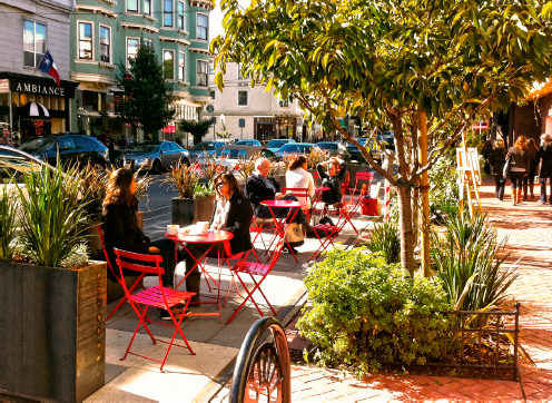
4.139 San Francisco planning commissioner John Rahaim describes the city’s Pavement2Parks initiative as “a laboratory in which all kinds of people . . . figure out what to do with all the wasted pavement we have in our city.”58
Courtesy San Francisco Planning Department
Tactical urbanism
During the decade Birmingham, Alabama, stakeholders spent planning and designing Railroad Park, a new school of thinking about the public realm emerged. Variously called guerilla, tactical, or “pop-up” urbanism, it takes a different approach to promoting community by creating immediate, usually temporary, and often unauthorized changes in public places to show how much better those places would look and function if the changes were made permanent. The Dallas-based Build Better Blocks advocacy group, for example, demonstrates potential improvements in targeted areas by introducing temporary bike infrastructure, landscaping, café seating, pop-up retail, art installations, and performances, and it encourages community groups to copy or alter its model for their own neighborhoods. Tactical urbanism sometimes also addresses more abstract issues, as when urban design student Matt Tomasulo challenged car-focused thinking in downtown Raleigh, North Carolina, by posting homemade signs with directions and walking times to nearby attractions.
In these examples, as in much of truly grassroots tactical urbanism, the design often encodes a political message. Build Better Blocks projects show how a different approach to streets and sidewalks can create a more appealing (and often more economically successful) urban realm. Tomasulo’s signs contained an implicit rebuke of car culture and suggested that simply communicating the existence of walkable connections might have almost as much impact as actually creating those connections. Tactical urbanism has gained momentum as municipal governments have begun to see it as a way to field-test ideas that yields quick, visible results.
Enduring and new forces shaping public realm: Protest and social media
Serving as the primary forum for public protest has been a fundamental role, and perhaps the most complex dimension, of public realm from the first days of urban settlement. The modernist László Moholy-Nagy’s statement that “no history was made in villages” is not about condemning rural life to obscurity but emphasizing how many of the great turning points in human history took place in urban streets and squares. Crowds gathered in ancient Mesopotamian cities to impel their leaders to war—or to sue for peace. In How the Greeks Built Cities (1976), the historian R. E. Wycherley describes the agora as the place where early democracy took root. Romans rallied in their city’s squares to oust kings and centuries later to install emperors. In the squares of Renaissance Europe, an emerging middle class claimed power from feudal lords and launched a long march toward modern Western democracy. The Arab Spring took hold in places like Cairo’s Tahrir Square. In America, public demonstrations built the momentum that ended slavery and won women the right to vote. The battles over civil rights took place along public streets and in public parks. More recently, the Occupy Movement woke Americans to the reality of growing economic disparity.
But the right to protest has never been secure in America or the rest of the world. This insecurity stems, of course, from the fact that those in power frequently seek to suppress dissent. Other factors, however, also contribute significantly. By its very nature, protest calls into question the status quo, and the public realm is very much about enshrining the status quo. Wycherley notes that the Greek agora had many other purposes—commerce, religion, social life, and celebrating the rituals that enshrined existing conditions. Virtually all of the worthy roles described above for the public realm—including the opportunity to experience community—are disrupted by protest. The Pulitzer Prize–winning architect and critic Robert Campbell observed after chancing upon a New York Yankees celebration in New York City in 2010 that “the best open space . . . for any kind of demonstration is one that normally has another use but has been appropriated by the demonstrators. The act of annexation becomes a metaphor for the energy of the cause.”60
Often subtly and in ways we may not recognize, Americans, like members of every other society, discourage this annexation and limit protest in public places. The methods by which we discourage protest are not always overtly political, and sometimes begin with design and then extend to policy. Trees, fountains, cafés, and similar amenities invite people to enjoy a public space, but one that can therefore be damaged if used for protest. Requiring permits for using a public space can safeguard the public’s enjoyment of a park but make exercising the right to protest expensive and more difficult. These challenges can be resolved for public space by ensuring that the public realm is also a civic realm—that it includes prominent places that are designed to allow large crowds to gather. When the space a community considers public realm is, in fact, private, resolving these challenges grows more problematic.
The Occupy Movement in New York highlighted this shift. The very place where people gathered to protest cooption of the public good by private enterprise, Zuccotti Park, was in fact owned by private enterprise. America has a long tradition of turning to private wealth to pay for the public realm (which in recent decades has extended to affordable housing and other public benefits). Industrial magnates funded many of the civic spaces that we revere today as gestures of civic noblesse oblige. These gestures brought prestige—and even political clout for a period of time—but the public owned the spaces, and the city could be held accountable for limiting exercise of citizens’ First Amendment rights. Over the past three decades in particular, a new generation of public/private partnerships has produced a wealth of “public” spaces built by private interests in return for zoning variances and other development incentives. These spaces are often function as the core element of an ambitious redevelopment initiative and may become integral to community life. However, these spaces represent innovative business deals and not civic contributions, and they typically remain under private ownership.
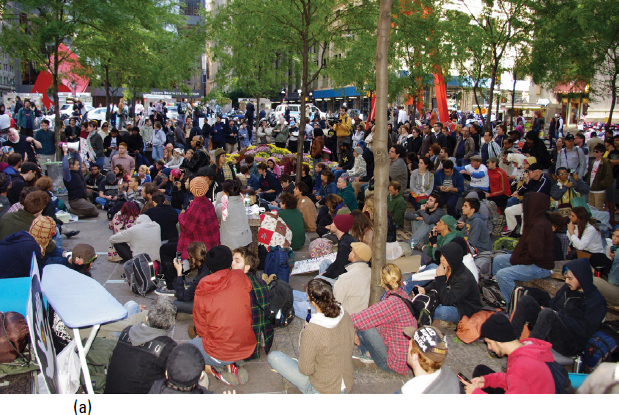
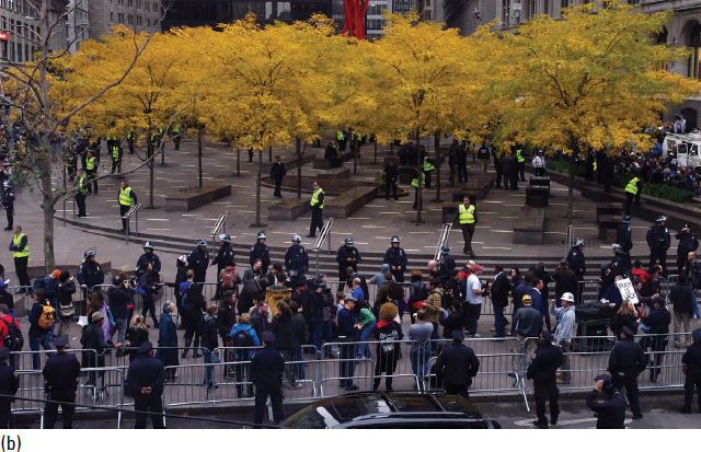
4.140 a,b Zuccotti Park full of protestors and after police evicted Occupy participants. The 2011 Occupy Movement reminded Americans that the foremost role of public space is to accommodate the right to protest—and raised serious questions about the expansion of privately owned “public space” created through development negotiations and often without regard for the full meaning of public realm.
Courtesy Wikimedia user David Shankbone
The occupation of Zuccotti Park revealed the loss of civic capacity when private interests own seemingly public spaces. The corporate entity that owned the park appealed to the sacrosanct right of property owners to evict the protesters—and in the process made clear that Zuccotti Park and similarly conceived spaces across America do not truly belong to the public realm unless the right of public protest is central to their very conception.
If the issues raised by public protest may be the oldest challenges associated with public realm, those raised by social media may be the newest. Social media represent yet another in a chain of technological developments that, over a little more than a century, have threatened the end of public life and, therefore, of public realm. In the nineteenth century, Austrian architect and theorist Camillo Sitte worried that “modern life” undermined the capacity to appreciate the beauty and civic value of public spaces. The telephone, automobile, television, computer, laptop computer, and Internet have all, in their turn, caused observers to worry over the impending abandonment of public parks and squares in favor of the comfort, familiarity, and safety of private domains. In the 1960s, architect Robert Venturi mounted an exhibit at the Los Angeles County Art Museum that argued that the universal popularity of telephones, cars, and televisions made cities unnecessary. For example, television-equipped family rooms had made gathering in downtown squares for major events appear outmoded; suburban backyards had done the same thing for public parks. In the early 1990s, many observers predicted that the combination of telephones and computers would unleash an era of telecommuting, then a novel concept, that would render cities—and their public spaces—anachronistic.
Technology has, in fact, changed the ways in which people use the public realm. Most notably, as cars fostered a mass exodus to the suburbs, bustling urban squares once full of people of every social class increasingly became the domain of the urban poor, while new regional parks—and park systems—became destinations for suburban families. Interestingly, universal access to computers and the Internet has had an effect on behavior opposite to that predicted. Focus group studies with younger technology workers who have no office have revealed that technology-related isolation fuels a desire to live and work in places with lively, walkable public realms that provide a ready sense of community.
The impact of social media continues to unfold. However, earlier fears that mobile devices that allow people to connect anywhere, instantly, would rob public streets, squares, and parks of their central role in public life have proven unfounded. Instead, social media enhance the personal and social value of the public realm. People use the ability to share information in real time to expand and intensify the ways they use public spaces. Friends make spur-of-the-moment plans to meet at a café, or even conjure up a flash mob in which ten or one hundred or more people perform a coordinated act in a public space, such as a dance at Grand Central Station in New York City. And thousands can be summoned quickly for a political protest. Social media brings immediate, widespread attention to aspects of the public realm—a new work of public art or a recently scheduled outdoor performance, for example—that for centuries have been the esoteric province of a few. The ability to post a video that can instantaneously be viewed by millions all around the world means that public places have assumed the role of a public stage unimagined just a decade ago. The same technology that might have empowered people to retreat to their private realms has instead unleashed a new generation of opportunities for the public realm.
Urban agriculture
Tactical urbanism also feeds into the urban agricultural movement of the last decade. The Natural Resources Defense Council’s Kaid Benfield points out that concerns such as sustainability, nutritional deficits that plague poor neighborhoods, and even the “slow food” movement have all fueled urban agricultural efforts, and urban agriculture shares tactical urbanism’s interest in exploring ways to create and celebrate community.62 In the spirit of San Francisco’s Pavement2Parks initiative, this dimension builds on the tradition of World War II victory gardens to reclaim vacant or underutilized urban sites or to colonize the flat roofs of industrial buildings as places where neighbors can garden together and enjoy the harvest in neighborhood restaurants or at community fairs and communal meals.
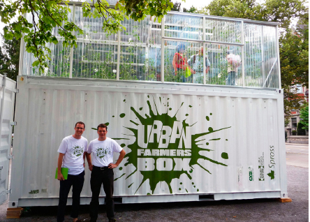
4.144 Urban farming in Chicago is a symbol of community spirit that is reermerging as a neighborhood-based business.
Courtesy Flickr user Hayal Oezkan
The urban agriculture movement, largely unnoticed until recent years, has been around since just after World War II, when residents of poorer urban neighborhoods began turning vacant lots into community gardens and parks. In New York City’s Harlem and Lower East Side, residents used these open spaces to grow both food and flowers, and the gardens themselves often became rallying points for organizing against development plans by property owners, usually the city itself, when the real-estate market shifted. A flowering of interest in sustainability and locally produced food that began in the 1990s made urban farming more popular—to the point that some proponents began to see the commercial possibilities of urban farming. The increasing sophistication of technology for green roofs, originally an energy-saving strategy, encouraged the development of arable rooftops and supported the emergence of sizable urban farms like Brooklyn Grange, Chicago Botanic Garden, and Boston’s Higher Ground.
By 2012, following the Occupy Wall Street movement and the attention it brought to the nature of public space and the right to use it, organizations like 596 Acres began lobbying for the right to garden and farm unused urban land. In a bankrupt Detroit and financially troubled Louisville, the use of inner-city land for agriculture recalls the victory garden movements of the two world wars. Guerilla gardening emerged in the 1960s—gardening on vacant property without the owner’s permission. Initial examples include People’s Park in Berkeley, California, and Adam Purple’s Garden of Eden on New York City’s Lower East Side.
Two examples demonstrate the community-building potential of urban agriculture. Both represent a commitment not to reduce density or urban vitality to make room for agriculture, but rather to employ agriculture to enhance livability and vitality. The architecture firm Perkins + Will’s plan to redevelop the City Centre Airport in Edmonton, Alberta, proposes establishing a small urban farm in place of decorative landscaping or a passive park as a focus for life in a new neighborhood.63 Via Verde, a mixed-income housing development in the Bronx, won a national competition for sustainable and healthy affordable housing sponsored by the New York City AIA chapter. Designed by Grimshaw Architects and Dattner Architects, it incorporates a series of cascading roofs designed to support community agriculture.64