Chapter 6
Remote Sensing of Atmospheric Aerosols
6.1 Introduction
Atmospheric aerosols are liquid or solid particles suspended in the atmosphere, with radii varying from a few nanometers to tens of micrometers. These particles can be directly emitted by anthropogenic (e.g. fossil-fuel burning) and natural (e.g. dust, maritime aerosol, volcanic ash) sources or can form from precursor gases (e.g. secondary organic aerosol, sulfates, etc.). Interest in the study of atmospheric aerosols can be dated back to the 1920s (Brav, 1929). Since then, significant improvement has occurred in our understanding of the role of aerosols in air quality (Lelieveld et al., 2002; Chow and Watson, 2007) and the earth's energy budget (Haywood and Boucher, 2000; Yu et al., 2006). Geographically localized sources/sinks and transformations within their short lifetimes (e.g. the mixing of various aerosol species, the hygroscopic growth of particles) lead to extreme spatial and temporal heterogeneity in aerosol optical and microphysical properties.
Aerosols influence the earth's radiative budget through three different mechanisms: first, they directly scatter and absorb solar and terrestrial radiation (Charlson and Pilat, 1969; Charlson et al., 1992; Chylek and Wong, 1995; Haywood and Boucher, 2000; Ramanathan et al., 2001; Boucher and Pham, 2002; Bellouin et al., 2005); second, they act as cloud condensation nuclei (CCN) and thereby affect cloud albedo and lifetime (Twomey, 1977; Albrecht, 1989; Lohmann and Feichter, 2005; Andreae and Rosenfeld, 2008); and third, their direct absorption of solar radiation can alter the thermal structure of the atmosphere and hence cloud formation (Hansen, Sato, and Ruedy, 1997; Ackerman et al., 2000; Koren et al., 2004, 2008; Johnson, Shine, and Forster, 2004). Perturbation of net (downward minus upward) radiation by aerosols through all the three mechanisms is quantified by aerosol radiative forcing. Global mean aerosol direct and indirect (only cloud albedo effect) radiative forcing is virtually certain to be negative, with a median value of −1.3 W m−2 and of −2.2 to −0.5 W m−2, respectively, at 90% confidence range (IPCC, 2007). However, large uncertainty continues to exist in quantifying aerosol radiative forcing because of the poor representation of aerosols in climate models, due to inadequate data on aerosol spectral optical properties at large spatiotemporal scale and the complex interaction between aerosols, clouds, and meteorology (Stevens and Feingold, 2009).
Aerosol concentration in the atmospheric column is quantified by aerosol optical depth (AOD), which is a measure of the columnar extinction (scattering and absorption) of solar radiation by aerosols. Precise measurements of AOD, single scattering albedo (SSA) (a measure of the scattering and absorbing nature of the particles), and phase function (a measure of angular distribution of scattered radiation) are required at a global scale to reduce the uncertainty in aerosol radiative forcing. Advancements in remote sensing techniques in the last 3 decades have provided much-needed data from the local to the global scale, which have been extensively used by scientists, policy makers, and the general public. Over the years, remote sensing applications of aerosols have evolved through experience. As more direct in situ observations have become available for the evaluation of remote-sensing-based retrievals, algorithms have been modified to reduce the retrieval error. The sensors, which were originally launched for other purposes, have also been utilized to derive information about aerosol properties. New techniques (e.g. polarimetric measurements, multiangle view) have been proposed to address the unresolved issues in aerosol remote sensing. The purpose of this chapter is to provide a comprehensive overview of these state-of-the-art retrieval techniques, their applicability for climate studies, and future requirements in this field.
6.2 Surface-Based Remote Sensing
The most accurate information about aerosol characteristics can be obtained through ground-based remote sensing, as it does not have to deal with surface reflectance issues. Such techniques have expanded in the last 2 decades, providing valuable data for the validation of satellite-based products and models.
6.2.1 Passive Remote Sensing
There are a number of international and national networks that maintain ground-based monitoring of aerosol properties using passive remote sensing techniques. AOD can be determined from the ground by radiometers that measure the direct spectral transmission of solar radiation through the atmosphere. The solar irradiance I at any given wavelength λ can be expressed as Iλ = I0λ exp(−mτ), where I0 is the solar irradiance at the top of the atmosphere, m is the air mass, and τ is the total optical depth. τ may be composed of scattering by gaseous molecules (commonly known as Rayleigh scattering), extinction by aerosols, and absorption by trace gases. The contribution by components other than aerosols can be accurately estimated, and subtracting them from τ gives AOD.
The most popular and widespread ground-based network of aerosol remote sensing is the Aerosol Robotic Network (AERONET), which maintains well-calibrated sunphotometers and sky-radiance radiometers (Holben et al., 1998, 2001). The radiometers measure direct sun radiance in eight spectral bands (between 340 and 1020 nm) across 10 seconds. A sequence of three such measurements is taken at 15-minute intervals in order to minimize the influence of clouds on the measured radiance. Sky-radiance measurements in the almucanter and principal plane are carried out at 440, 670, 870, and 1020 nm wavelengths in order to acquire a large range of scattering angles for the retrieval of size distribution, phase function, and SSA (Dubovik and King, 2000). AERONET-retrieved AOD is highly accurate, with an uncertainty <± 0.01 for wavelengths greater than 440 nm and <± 0.02 for shorter wavelengths. The aerosol optical properties are retrieved with greater accuracy for AOD440 ≥ 0.5 with solar zenith angle > 50° (Dubovik et al., 2000). AERONET data have been used by numerous researchers to examine aerosol characteristics and composition in several regions of the world.
6.2.1.1 Aerosol Optical Properties
Major aerosol types are characterized by their microphysical (particle size and shape) and optical (ability to scatter and/or absorb radiation) properties. For example, both urban/industrial and biomass-burning aerosols are small in size and spherical in shape, but the biomass aerosols have much lower SSA (i.e. more absorbing) than urban/industrial aerosols. Natural aerosols (e.g. dust and maritime) are large in size, but dust particles have lower SSA than maritime particles and they are nonspherical in shape. Thus, if these properties can be measured by remote sensing techniques, dominant aerosol types can be identified. However, it must be noted that various individual particles often mix with one another, altering the optical properties of composite aerosols. The optical properties for key aerosol types have been summarized by Dubovik et al. (2002), utilizing the AERONET measurements. These results demonstrate the range of variability in aerosol optical properties across geographic regions, characterized by various anthropogenic and natural sources. Both biomass-burning and urban aerosols are characterized by a dominance of accumulation-mode particles and spectrally decreasing SSA. Desert dust aerosols are characterized by a dominance of coarse-mode particles and spectrally increasing SSA. However, absorption by dust particles varies depending on the hematite content (Koven and Fung, 2006; Mishra and Tripathi, 2008) and mixing with other species (e.g. Dey, Tripathi, and Mishra, 2008; Mishra et al., 2012). On the other hand, maritime aerosols are dominantly coarse-mode particles and scattering in nature. Oceans are natural test beds for quantifying the seasonal changes in regional aerosol properties, due to the seasonal transport of aerosols from the continents. The need to establish a robust climatology of maritime particles has led to the development of a Maritime Aerosol Network under AERONET (Smirnov et al., 2009). The globally averaged maritime AOD at 500 nm and the Angstrom exponent (AE, for the wavelength range 440–870 nm) derived from island-based AERONET measurements are 0.11 and 0.6, respectively. Mean annual AOD is observed to be low (<0.10) in the Pacific Ocean, but varies spatially and seasonally over the Atlantic and Indian Oceans (Figure 6.1). Cape Verde and Barbados site in the Atlantic Ocean are strongly affected by Saharan dust transport, while the Kaashidhoo site in the Indian Ocean is affected by pollution transport from the Indian subcontinent.
Figure 6.1 Mean annual (a) AOD at 500 nm and (b) Angstrom parameter, at various island-based AERONET sites. Reproduced with permission from Smirnov et al. (2009). Copyright © 2009, John Wiley and Sons Ltd. See plate section for colour version.

AE derived from spectral AOD measurements by ground-based radiometers also provides a qualitative indication of the dominant size, with values greater than 2 indicating small particles associated with combustion products and values less than 1 indicating large particles such as dust or maritime aerosols (Schuster, Dubovik, and Holben, 2006). Temporal changes in the dominant aerosol types are inferred based on changes in AE (Dey et al., 2004; Moorthy, Babu, and Satheesh, 2007; Kaskaoutis et al., 2010). However, AE also changes with wavelength, and the second-order AE (quantifying the change of AE with wavelength) provides additional information about aerosol size distribution. For example, AE calculated from longer wavelength pairs (λ = 670 and 870 nm) is sensitive to the fine-mode fraction, while AE calculated from shorter wavelength pairs (λ = 380 and 440 nm) is sensitive to the fine-mode effective radius (Schuster, Dubovik, and Holben, 2006). The curvature in the spectral distribution of AODs depends strongly on atmospheric turbidity (Kedia and Ramachandran, 2009). At low AOD (∼0.2), AE increases fourfold when the wavelength range is changed from shorter (400–500 nm) to longer (750–875 nm). The variability becomes high when mixing of various aerosol species occurs, altering the spectral AOD and absorption properties. An analysis of multiyear AERONET data at two urban sites in Asia (Kanpur and Beijing) revealed a similar spectral variation of SSA at a low (∼0.15) fine-mode fraction (Figure 6.2). This indicates the dominance of desert dust particles at these urban sites, which have similar hematite contents despite having different dust source regions (Eck et al., 2010). Both these sites have nearly equal SSAs at a high (∼0.85) fine-mode fraction, suggesting a similar nature of urban aerosols. At an intermediate fine-mode fraction (∼0.45), characteristic of the mixing of fine- and coarse-mode particles, the SSA at near-infrared wavelength is smaller in Beijing than in Kanpur. This implies that coarse-mode dust particles are more absorbing in Beijing than in Kanpur, which may result from a greater rate of black carbon (BC) coating of dust particles in Beijing. In another AERONET-based study, Giles et al. (2012) observed higher absorption by dust particles mixed with smoke than by pure dust.
Figure 6.2 Comparison of spectral SSAs at Kanpur (26.5°N, 80.2°E) and Beijing (39.9°N, 116.4°E) for low (∼0.15), medium (∼0.45), and high (∼0.85) fine-mode fractions. Reproduced with permission from Eck et al. (2010). Copyright © 2010, American Geophysical Union. See plate section for colour version.

6.2.1.2 Aerosol Composition
The scarcity of aerosol composition data at the global scale hinders in the improvement of climate models and this has led scientists to explore the utilization of measured spectral aerosol optical properties (by sunphotometers or any other radiometers) to infer aerosol composition. In recent years, two different approaches have been adopted. In the first, a combination of aerosol parameters is used to infer aerosol composition. For example, Gobbi et al. (2007) have proposed a method for characterizing urban, biomass-burning, and dust aerosols using the spectral curvatures of AOD and the AE (an indicator of dominant aerosol size). Fine-mode-fraction and SSA measurements by sunphotometers are used to separate out dust, maritime, nonabsorbing, and absorbing anthropogenic aerosols (Lee et al., 2010). Statistics show that North and South Asia, South America, and South Africa are dominated by absorbing aerosols emitted by anthropogenic activities and biomass burning (annual occurrences of 66.2, 89.2, 76.8, and 94.5%, respectively). The dust emission from the Saharan Desert dominates the air mass in North Africa (73.8% annual occurrence), nonabsorbing urban/industrial aerosols dominate North American sites, while Europe has mixed air mass. A similar approach was taken by Srivastava et al. (2012) to distinguish air masses dominated by various aerosol types (e.g. polluted dust, clean dust, polluted continental, high-absorbing, and low-absorbing) over the polluted Indo-Gangetic basin in Northern India during the pre-monsoon season (Mar-May).
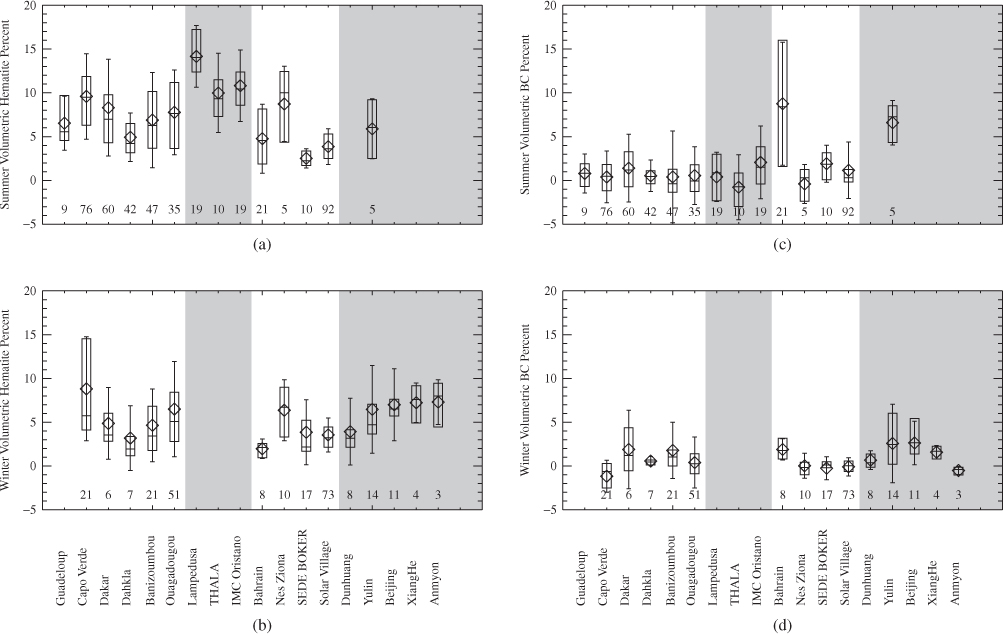
In the second approach, composite aerosols are assumed to be a mixture of various individual species. The composite refractive indices are estimated theoretically by varying the volume fractions of the individual components constrained by AERONET-retrieved refractive indices. The volume fractions are then multiplied by the density of the species of interest and AERONET-retrieved total volume concentration to derive the columnar mass concentration. Schuster et al. (2005) implemented this idea by applying the Maxwell–Garnett mixing rule to an aerosol mixture containing BC, ammonium sulfate, and water and calculated the complex refractive indices. The simulations constrained by AERONET measurements have allowed an estimation of columnar BC concentrations at 46 AERONET sites across the world. The largest BC concentrations at biomass-burning sites and the lowest concentrations at the remote island sites (Figure 6.3) qualitatively justify the approach. Dey et al. (2006) have extended the methodology by including partly absorbing organic carbon and dust in the mixture in order to examine their impacts on the retrieval of BC at a site in the Indo-Gangetic Basin in northern India. Absorbing organic carbon concentrations have also been quantified using the same approach (Arola et al., 2011). Koven and Fung (2006) have adopted the approach to infer the hematite content (which determines the absorptive nature of dust) of dust aerosols at AERONET sites dominated by desert dusts. They concluded that the calculated hematite content is highly sensitive to mixing assumptions. External mixing overestimates hematite content, while internal mixing underestimates it (Figure 6.4). A higher hematite content is observed in Saharan and East Asian dust than in Arabian dust. These results provide an alternative approach (in the absence of robust in situ data) to improve the quantification of dust absorption and its impact on direct radiative forcing.
Figure 6.3 Black carbon (BC) concentration at various AERONET sites in North America (red), Europe (gray), Asia (purple), South America (green), Africa (orange), Atlantic Islands (light blue), and Pacific Islands (dark blue) for the year 2000 (circles) and 2001 (squares). Reproduced with permission from Schuster et al. (2005). Copyright © 2005, American Geophysical Union. See plate section for colour version.

Figure 6.4 Hematite content in aerosols at various AERONET stations during the summer–fall season (top panel) and the winter–spring season (bottom panel), using external (left panel) and internal mixing (right panel). Reproduced with permission from Koven and Fung (2006). Copyright © 2006, American Geophysical Union.
6.2.2 Active Remote Sensing
Surface-based passive remote sensing can provide information about columnar aerosol properties, but the vertical profiles of aerosols can be measured only by active remote sensing. Micro-pulse lidar (MPL) is a very popular instrument due to its portability, and a network (the Micro-Pulse Lidar Network, MPLNET) has been established at AERONET sites over the years (Welton et al., 2001). MPL measures the aerosol backscatter coefficient profile at 532 nm wavelength at a very high vertical resolution (30–75 m). Calibration of the MPL system involves correction of the afterpulse and overlap functions (Welton and Campbell, 2002). Ground-based lidars have been used to measure aerosol profiles in continuous and campaign modes (Welton et al., 2000). In the Indian Ocean Experiment, MPL data were utilized to elucidate the temporal evolution of marine boundary layer heights during the winter season. Aerosols were observed to be mostly confined below 1 km altitude, while the extinction backscatter ratio provided additional information about the type of air mass sampled (Welton et al., 2002). Lidar data were also used to detect dust layers and mixing with other spherical particles (Liu et al., 2011a).
These datasets are also a valuable tool in evaluating spaceborne active remote sensing measurements (e.g. Campbell et al., 2012; Misra et al., 2012). Besides these studies on the vertical profiles of aerosols, lidar data are also used to constrain satellite-based estimates of the surface concentrations of aerosols for health-impact studies (Liu et al., 2011b).
6.3 Satellite-Based Remote Sensing
Satellites provide the space–time coverage required to monitor atmospheric aerosol concentration at the global scale and complement ground-based monitoring. Satellite remote sensing applications began to retrieve information on aerosol properties (e.g. AOD or absorbing aerosol index (AAI)) some 30 years ago (Lee et al., 2009). The Multi Spectral Scanner (MSS) onboard the Earth Resources Technology Satellite (ERTS-1) was the first sensor used to retrieve AOD (Griggs, 1975). However, the Advanced Very High Resolution Radiometer (AVHRR) onboard the TIROS-N satellite was the first to be used for operational aerosol products (Stowe et al., 2002). Originally launched for weather observations, AVHRR's ability to measure reflected solar radiation at visible and mid-infrared wavelengths was utilized for aerosol retrieval. Since then, a number of passive sensors have been launched to measure aerosols over ocean and land (Figure 6.5). Early passive sensors were developed for other purposes (e.g. Total Ozone Mapping Spectrometer, TOMS was launched onboard the Nimbus 7 satellite in order to detect ozone, but its ultraviolet (UV) bands were used to measure absorbing aerosols), but their measurement capabilities have been utilized to retrieve aerosol properties, with varying success. Our understanding of the limitations of existing sensors in measuring aerosol properties has led to the development of more robust techniques. Recently, an active remote sensing technique was utilized to retrieve aerosol vertical distributions, adding a new dimension to aerosol remote sensing. This section summarizes the passive and active remote sensing applications in aerosol studies over the last 3 decades.
Figure 6.5 Temporal coverage of various satellites/sensors utilized to monitor aerosols.

6.3.1 Passive Remote Sensing
Satellite observations are carried out from different orbits, view angles, and solar zenith angles, which vary with time of the day and season. Satellite-based retrievals of aerosol properties by passive sensors account for the viewing geometry in the radiative transfer model. The retrieval algorithms follow several steps. The first is the cloud screening, where a pixel is identified as ‘clear’ or ‘cloudy’. High reflectance of clouds in the pixel overshadows the ‘aerosol’ reflectance and hence aerosol cannot be detected in a cloudy pixel by passive remote sensing (Ackerman et al., 1998). Various cloud-masking techniques have been developed, based on the sensor characteristics. The next step is to separate the surface reflectance from clear-sky atmospheric reflectance. The contribution of molecular scattering and absorption to atmospheric reflectance is estimated using a radiative transfer model. Look-up tables (LUTs) are prepared in order to expedite the retrieval, with TOA radiance theoretically calculated for a set of aerosol models, taking into account the sun and sensor geometry. Aerosol properties are then retrieved by comparing the measured TOA radiance with the theoretical radiance values from the LUTs. Retrieved aerosol products at high resolution are reported as level 2 data. All level 2 pixels within a larger domain (typically at 1.0° or 0.5° grids) are averaged and reported as level 3 data, which are distributed on ‘daily’ and ‘monthly’ timescales. Aerosol remote sensing is currently carried out using UV and visible–near-infrared (VIS-NIR) wavelengths.
6.3.1.1 Aerosol Remote Sensing Using Near-UV
Aerosol detection capability in the near-UV wavelengths first became apparent with the development of the AAI, as a byproduct of the TOMS version 7 ozone algorithm (McPeters et al., 1996). The low and relatively invariant UV albedo of the earth's surface allows easy detection of aerosols over ocean and land (Herman and Celarier, 1997). TOMS provides daily coverage of most of the earth's surface at 50 × 50 km resolution at nadir. Aerosol measurements are carried out at the three longest wavelengths (340, 360, and 380 nm), at which gaseous absorption is weak and backscattered radiation is primarily influenced by Rayleigh scattering, surface reflection, and scattering from aerosols and clouds. AAI is defined as:
![]()
where Imeas is the measured backscattered radiance at a given wavelength and Icalc is the radiance calculated theoretically at that wavelength using an atmospheric model, assuming a pure gaseous atmosphere. The difference between the measured and calculated radiances is attributed to aerosols (in clear sky). Nonabsorbing aerosols (e.g. sulfates and maritime particles) yield negative AAI values, while absorbing aerosols (e.g. dust and smoke) yield positive values.
AAI is sensitive to the height of the aerosol layer (Mahowald and Dufresne, 2004) and hence has been extensively utilized in the study of global distributions of UV-absorbing mineral dust aerosols. Using 13 years of TOMS AAI data, Prospero et al. (2002) have identified the major global dust sources based on the frequency of high AAI (>0.7). On a global scale, the concentration of absorbing aerosols is higher in July than in January (Figure 6.6), and large sources are confined to the northern hemisphere. The absorbing aerosols are mostly mineral dust, except in southern Africa and the adjacent ocean, where the high AAI values are attributed to smoke (Hao and Liu, 1994). The index has also been used to study regional distributions of dust (e.g. Dey et al., 2004) and smoke (e.g. Gleason, Hsu, and Torres, 1998).
Figure 6.6 Global distributions of dust and smoke: monthly frequency of occurrence of TOMS absorbing aerosol product over the period 1980–1992. (a) January. (b) July. The scale is the number of days per month on which the absorbing aerosol index (AAI) equals or exceeds 0.7. The large dark area in southern Africa in July is a result of biomass burning. In January, there is biomass burning in the region just north of the equator in Africa; part of the plume over the equatorial ocean is due to smoke. Essentially, all other distributions are a result of dust. Reproduced with permission from Prospero et al. (2002). Copyright © 2002, American Geophysical Union.

In addition to AAI, AOD is also retrieved using UV wavelengths (Torres et al., 1998). The radiance measured by the sensor at the top of an aerosol-laden atmosphere consists of three terms: the radiance scattered upward by the aerosol layer, the fraction of Rayleigh-scattered and surface-reflected radiance below the aerosol layer, and the fraction of Rayleigh-scattered and surface-reflected radiance transmitted through the aerosol layer that is unaffected by aerosol absorption (Torres et al., 2002). Near-UV remote sensing of aerosols is different from VIS/NIR remote sensing in two aspects: first, the contribution of Rayleigh scattering to total radiance cannot be neglected in the near-UV region and varies depending on the height of the absorbing and scattering aerosol layer; and second, the low surface reflectance at near-UV allows for the retrieval of aerosols using similar algorithms over both water and land, with less error. Since the sensitivity of TOA radiance to aerosol height decreases with decreasing aerosol absorption, near-UV remote sensing is most suitable for the detection of absorbing aerosols (Torres et al., 1998).
The longest global record of AOD is provided by aerosol retrieval using near-UV remote sensing technique by TOMS sensor onboard Nimbus 7 (October 1978–April 1993), Meteor3 (August 1991–December 1994), and EP-TOMS (July 1996–December 2005). Figure 6.7 shows the inter-annual variability of latitudinal distribution of near-UV AOD that captures the broad regional features. High AOD at ∼50°N corresponds to boreal forest fires, while tropical biomass burning and desert dusts contribute to large AOD in the tropics. The influence of two major volcanic eruptions (El Chichon in 1982 and Mt Pinatubo in 1991) on global AOD is also evident. This data set can be utilized for further regional-scale study (e.g. Massie, Torres, and Smith, 2004).
Figure 6.7 Time series of the 380 nm aerosol optical depth during the period of operation of the TOMS instruments onboard the Nimbus 7 (1979–1992) and Earth Probe satellites (1996–2001). Weekly averages plotted over a 1 × 1° geographical grid. Reproduced from Torres et al. (2002) (with permission from American Meteorological Society). See plate section for colour version.

6.3.1.2 Aerosol Remote Sensing Using VIS-NIR
Satellite-based passive remote sensing of aerosols using the VIS-NIR wavelengths has gained prominence over the years due to the straightforward use of retrieved mid-visible AOD in climatic applications. However, different retrieval techniques are employed over water and land, in order to account for the surface reflectance effect.
GACP Dataset
AVHRR instruments onboard NOAA weather satellites are another source of long-term records of aerosol properties. The radiances of channel 1 and 2 of AVHRR were used to retrieve AOD and AE over global oceans and archived as the Global Aerosol Climatology Project (GACP) dataset, covering the period August 1981 to December 2005 (Mishchenko et al., 1999, 2007a, 2012; Geogdzhayev et al., 2002, 2005). The GACP algorithm is based on a modified power law size distribution within the range 0.1–10.0 µm (Mishchenko et al., 1999), where particles are assumed to be perfect spheres with complex refractive index m = 1.5 + 0.003i. This approach minimizes the long-term statistical errors of retrieved AOD and AE, but may have regional biases due to the mixing of aerosols from various sources.
The AOD retrieved by AVHRR shows similar global distribution (Figure 6.8) to AOD retrieved by Moderate Resolution Imaging Spectroradiometer (MODIS) and Multiangle Imaging SpectroRadiometer (MISR), which use multichannel retrieval algorithms. Dust outflows from the Saharan Desert to the Atlantic Ocean and large AODs over the Indian Ocean, near the coast and East Asia, are captured by all three sensors. However, the magnitude of AOD varies; AVHRR shows smaller AOD than the other two sensors in high-AOD regions affected by dust and transported continental aerosols. The different cloud screening and retrieval algorithms used by these sensors may also contribute to the discrepancy (Geogdzhayev et al., 2004; Mishchenko et al., 2007a). Nonetheless, the GACP dataset provides a valuable long-term record of AOD over global oceans. In a more recent work, Mishchenko et al. (2012) have shown that increasing the complex part of the refractive index in the AVHRR algorithm eliminates the previously identified long-term decreasing trend in global AOD (Mishchenko et al., 2007b). This implies that for a real trend, the mean global aerosol absorption must be doubled as compared to the existing algorithm, which translates to a decrease of mean global SSA from ∼0.95 to ∼0.88.
Figure 6.8 Global distribution of aerosol optical depth for the period March to July 2000 from three passive sensors: AVHRR, MODIS, and MISR. Reproduced with permission from Geogdzhayev et al. (2002). Copyright © 2004, Elsevier Ltd. See plate section for colour version.

MODIS and MISR Aerosol Products
A new era in satellite remote sensing of aerosols began with the launch of the polar-orbiting satellite EOS-Terra in the year 1999 (Figure 6.5). EOS-Terra carries five sensors, among them MODIS and MISR, which provided the first true global coverage of AOD. Later, MODIS was also launched onboard the Aqua satellite, in 2002, thereby increasing the temporal coverage. MODIS measures radiance at 36 wavelength bands (spanning from 0.415 to 14.5 µm) within a swath of ∼2330 km at moderately high spatial resolution (0.25, 0.5, and 1.0 km, depending on the bands).
The MODIS ‘dark-target’ aerosol retrieval algorithm was developed to quantify clear-sky aerosol properties (AOD and fine-mode fraction) over land surfaces with a low VIS-NIR reflectance (Levy, Remer, and Dubovik, 2007). The algorithm uses two visible (0.47 and 0.65 µm) and one short-wave infrared (SWIR, 2.1 µm) bands, which are nearly transparent to gaseous absorption and show a consistent spectral relationship over the surface of land (Kaufman et al., 1997). Aerosol is considered to be a mixture of fine- and coarse-mode particles, whose microphysical and optical properties are obtained based on a cluster analysis of AERONET data (Levy, Remer, and Dubovik, 2007). The algorithm considers three fine aerosol models that assume spherical particles with weak (SSA at 0.55 µm ≈ 0.95), moderate (SSA ≈ 0.91), and strong (SSA ≈ 0.86) absorption, and one coarse model that assumes nonspherical particles of SSA ≈ 0.95 (essentially representing dust). A LUT is created in which the TOA radiance values for different aerosol models plus Rayleigh scattering over a dark surface are theoretically estimated using radiative transfer model. Earlier (collection 4), the algorithm assumed negligible contribution of radiance by aerosols at a 2.1 µm channel, allowing the separation of surface reflectance from aerosol reflectance at the two visible channels, given a simple ratio of surface reflectance at VIS and SWIR channels (Remer et al., 2005). The TOA radiance from LUT is compared with the measured radiance at 0.47 and 0.65 µm channels in order to retrieve AOD, which is then interpolated to calculate AOD at 0.55 µm and reported as level 2 data.
The present algorithm (collection 5) considers spectrally consistent atmospheric radiance for each aerosol model coupled with Rayleigh scattering (Levy, Remer, and Dubovik, 2007), which allows direct-retrieval AOD at 0.55 µm and fine-mode fraction. AE is determined from AOD measurements at 0.47 and 0.65 µm. The MODIS collection 5 aerosol product is reported as level 2 data at 10 km spatial resolution. Along with the aerosol products, the quality of the retrieval (denoted QA) is also reported, based on a series of tests in the form of a quality-control flag (QAC). QAC summarizes the relative confidence in the entirety of the aerosol product, ranging from 0 (low or no confidence) to 3 (high confidence). Larger QAC values are more useful in the scientific applications outlined in Section 6.3.3.
Global validation of the previous version of aerosol product (Remer et al., 2005) revealed that >66% or one standard deviation of the over-land collocation points was contained within the expected-error (i.e. ±[0.05 + 0.15AOD]) envelope. In collection 5, 69% of the retrieved AODs lie within the expected-error envelope, with a closer match to the 1 : 1 line and a higher correlation relative to collection 4. However, categorization of the retrieved AOD using QAC in the global validation revealed that regression becomes more symmetric with the 1 : 1 line with an increase in QAC and that the percentage of data points lying within the expected error envelope increases from 50.34% for QC = 0 to 66.1, 67.75, and 72.6% for QAC = 1, 2, and 3, respectively (Levy et al., 2010). The variation of the bias in MODIS-AOD in comparison to AERONET is shown in Figure 6.9 for all collocated QAC = 3 data points. Across a wide range of AODs, the mean bias (marked by black boxes) of MODIS-AOD is less than 0.01 and the 66% interval (i.e. 1 − σ, shown as red lines) and the expected error envelopes (shown as green lines) are almost identical. This further establishes the importance of quality flag for scientific applications.
Figure 6.9 Absolute error of AOD (MODIS-AERONET) vs. AERONET-AOD at 0.55 µm, for QAC = 3. Data sorted by AERONET AOD and grouped into 50 equal bins. Each box plot represents the statistics of the MODIS-AERONET differences in the bin. The means and standard deviations of the AERONET AOD are the centers and half-widths in the horizontal (red). The mean, medians, and 66% (1 − σ) interval of the MODIS-AERONET differences are the black squares, with the center and top–bottom red intervals in the vertical (also red). The blue whiskers are the 96% (2 − σ) intervals. The red dashed curves are linear best fits to 1 − σ intervals and the green dashed curves are the over-land expected errors for total AOD ± (0.05 + 0.15). Reproduced with permission from Levy et al. (2010). Copyright © 2010, Levy et al. See plate section for colour version.

MISR, launched aboard the NASA EOS-Terra satellite (along with MODIS), is unique in having a combination of a high spatial resolution, a wide range of along-track view angles, and a high accuracy of radiometric calibration and stability (Diner et al., 1998). MISR measures upwelling short-wave radiance at 446, 558, 672, and 867 nm using nine cameras, spread out in the forward and aft directions along the flight path at 70.5°, 60.0°, 45.6°, 26.1°, and nadir. A 380 km-wide swath of the earth is successively viewed by each of the nine cameras within 7 minutes, allowing the measurement of a very large range of scattering angles, which enables the retrieval of aerosol microphysical properties (Kahn et al., 2010). The multiangle view enhances the sensitivity to optically thin aerosol layers and allows the retrieval algorithm to differentiate surface and atmospheric contributions to TOA radiance.
MISR retrieves AOD and other microphysical properties (size and shape of the particles and SSA) at 17.6 × 17.6 km resolution as a level 2 product, by analyzing data from 16 × 16 pixels of 1.1 km resolution (Kahn et al., 2009). The retrieval strategy assumes a laterally homogeneous distribution of aerosols within the 17.6 × 17.6 km region and so no retrieval is performed over land when the surface topography is determined to be complex (e.g. in mountainous terrain). The latest (Version 22) algorithm assumes 74 types of modeled aerosol mixture in the LUT. The radiance of each of these mixtures is matched with the measured radiance and the particle properties of the mixture with the lowest chi-square value of all the successful mixtures passing the threshold test during radiance matching are reported as ‘best estimates’. The aerosol product includes spectral AOD and SSA at all four MISR channels, the fraction of AOD due to ‘fine’ (particle radius < 0.35 µm), ‘medium’ (radius between 0.35 and 0.7 µm), and ‘coarse’ (radius > 0.7 µm) size, and the fraction of AOD due to ‘spherical’ and ‘nonspherical’ particles (Kahn et al., 2009). This version improves upon the previous versions with the incorporation of a more realistic medium-mode desert dust (Kalashnikova et al., 2005), spherical particles with mid-visible SSA in the range 0.8–0.9, and more multimodal size distributions, among other things. Many of these properties are unique to MISR.
The global validation of MISR AOD is summarized in Figure 6.10, where 3.7% of data are outliers and are not included in the statistics. Most of the outliers are due to sampling differences (Kahn et al., 2010). The quality of the retrieval varies depending on the major aerosol type. For example, 70–75% of data fall within 0.05 or 20% × AOD of the validation data and about 50–55% meet the stricter criteria, except for the ‘dust’ and ‘hybrid’ categories. Version 22 values are 10, 7, and 6% higher than those for earlier versions for the ‘biomass-burning’, ‘continental’, and ‘maritime’ categories, respectively, suggesting improvements in the retrieval. The validation also suggests a requirement for a mixture of smoke and dust in the LUT. Validation with AERONET revealed that MISR overestimates AE, due to the absence of any channel greater than 867 nm and the limited use of medium-sized spherical particles in the LUT. Like MODIS, MISR also provides additional information (e.g. quality of retrieval, number of successful mixtures passing the chi-square test, retrieval success flag, etc.) that helps in understanding the quality of the retrieval and interpretation of the data for scientific applications.
Figure 6.10 MISR AOD bias relative to AERONET (in %) for all coincident samples stratified according to the dominant aerosol air-mass type. Filled diamonds and circles represent the class-averaged percentage meeting regular (0.05 or 20% × AOD) and more stringent (0.03 or 10% × AOD) criteria, respectively. Open symbols represent class average results for the earlier version of the product from Kahn et al. (2005). Figure adapted from Kahn et al. (2010) (with permission from AGU). See plate section for colour version.

Applicability and Intercomparison of Satellite-Based Aerosol Products
Due to the increased attention being given to the effect of aerosols on the climate, the number of satellite-based aerosol products has increased rapidly in the last decade. In addition to those mentioned in the previous sections, many other sensors (e.g. SeaWiFS, VIRS, AATSR, ATSR-2, POLDER) also provide aerosol products. However, the availability of multiple datasets for similar applications also increases the possibility of misinterpretion. Many recent studies have focused on the intercomparison of various satellite-based aerosol products and revealed a large discrepancy between them (e.g. Myhre et al., 2004, 2005; Liu and Mishchenko, 2008; Li et al., 2009; Mishchenko et al., 2009). Discrepancy is not unexpected as the quality of the retrieval depends on numerous factors (including instrument calibration, cloud masking techniques, algorithms, and the treatment of surface reflectance). Retrieval algorithms have been modified over the years to improve the quality of the aerosol product but a lack of proper interpretation of data quality and its applicability still exists among the user community. Often AODs from multiple sensors, averaged over monthly or seasonal timescales, are intercompared without consideration of the spatial and temporal density of measurements relative to the gradients of true AOD (Levy et al., 2009).
Kahn et al. (2009, 2011) have demonstrated the right approach for the interpretation of multi-sensor inter-comparison, using coincident samples. Key issues that should be considered are: (i) the collocation of measurements, (ii) the treatment of outliers, and (iii) the choice of an absolute or relative criterion, depending on the situation at hand. For example, despite being onboard the same satellite, Terra, MISR, and MODIS do not retrieve AODs at the exact same location. This can lead to sampling differences, particularly in regions with a large spatial variability in AOD (Kahn et al., 2011). The three clusters of outliers in the MISR-MODIS comparison (Figure 6.6 of Kahn et al., 2009) correspond to North-Central Africa, the eastern part of the Indo-Gangetic Basin, the Patagonia Desert in South America, and North-Central Australia. The discrepancy in North-Central Africa stems from the lack of a smoke–dust mixture in the MISR retrieval algorithm, while neither MODIS nor MISR considers the appropriate SSA when retrieving aerosols in the Indo-Gangetic Basin. The third cluster is attributed to the error in treatment of surface reflectance by the MODIS land algorithm. For a direct comparison, an absolute criterion is needed at very low AOD, where the sensitivity of the sensor is low. On the other hand, a relative criterion is useful for comparing AODs well above the limit of measurement sensitivity, in order to account for such issues as sampling differences and spatial variability. Often the combined use of MODIS and MISR provides better information (e.g. Kalashnikova and Kahn, 2008). These data are utilized in various applications, as summarized in Section 6.3.3.
6.3.2 Active Spaceborne Lidar
One of the major factors influencing the quality of retrieval of aerosol properties using passive remote sensing techniques is the impact of clouds. Undetected clouds within clear pixels enhance the TOA radiance. Even when a pixel is identified correctly as ‘clear’, aerosol retrieval in that pixel is influenced by enhanced reflectance from cloud edge (Wen, Marshak, and Cahalan, 2006). This artifact can impact the interpretation of aerosol–cloud interaction based on remote sensing data (Loeb and Schuster, 2008; Koren et al., 2007). Aerosol and cloud can be simultaneously detected within a pixel using active remote sensing. Moreover, active remote sensing can provide information on aerosol vertical profiles in both day and night, unlike the daytime-only retrieval of columnar aerosol properties by passive sensors.
CALIOP was launched onboard the CALIPSO satellite as part of a constellation of satellites popularly known as the ‘A-Train’ (Stephens et al., 2002) in the year 2006. It measures the vertical profiles of two orthogonal polarization components of attenuated backscatter at 532 nm (at 30 m vertical resolution and 1/3 km horizontal resolution below 8.2 km altitude, and at 60 m vertical and 1 km horizontal resolution between 8.2 and 20.2 km altitude) and of total backscatter at 1064 nm (at 60 m vertical resolution). Color ratio (ratio of 532 and 1064 nm backscatter) is utilized to distinguish between aerosol and clouds. Furthermore, utilizing the sensitivity of the volume depolarization ratio, VDR (the ratio of the layer integrated perpendicular to parallel components of 532 nm backscatter) to the irregularity of particle shape, nonspherical dusts can be separated out from other spherical particles (Liu et al., 2008). Comparison with ground-based lidar reveals a poor match closer to the surface, primarily due to uncertainty in the assumption of the lidar ratio in the CALIPSO algorithm, combined with a low sensitivity as the signal gets attenuated closer to the surface by the presence of a heavy aerosol layer aloft (Misra et al., 2012).
Nonetheless, CALIPSO measurements provide an opportunity to study aerosol vertical distributions on a global scale, which is critical in quantifying the aerosol-induced radiative effect. CALIPSO profiles have been used to examine aerosol transport (e.g. Liu et al., 2008; Abdi Vishkaee et al., 2012; Cabello et al., 2012; Di Pierro, Jaegle, and Anderson, 2011), aerosol distribution (e.g. Chen et al., 2012; Mishra and Shibata, 2012), aerosol radiative forcing (e.g. Chand et al., 2009), and the validation of climate models (e.g. Koffi et al., 2012).
6.3.3 Applications of Satellite-Based Aerosol Products
Perception of the importance of aerosols to the earth's climate has changed as a result of the capabilities of new-generation sensors in measuring aerosol properties on a global scale (Kaufman, Tanre, and Boucher, 2000). Satellite aerosol products are currently being applied for numerous scientific purposes (e.g. time-series analysis, aerosol characterization at various spatial and temporal scales, estimation of aerosol radiative forcing, aerosol–cloud interaction, validation of climate models, near-surface aerosol concentration for health studies). This section summarizes these applications and discusses caveats on their applicability.
6.3.3.1 Aerosol Characterization, Trends, and Radiative Forcing
Satellite-based aerosol products (columnar and vertical distributions) providing near-global coverage have helped reduce the uncertainty of aerosol direct radiative forcing, as is evident from IPCC AR3 (pre-Terra era) and AR4 (post-Terra era). While the GACP dataset provides fairly long-term (26 years) records of AOD over oceans, MODIS and MISR aerosol products provide near-global measurements of aerosol properties for the last 12 years (and continuing). These data have been utilized in the last decade to improve our understanding of the space–time distributions of aerosol properties. The transition from global dimming to brightening in recent years, as revealed by ground-based measurements of solar radiation (Wild et al., 2005), matches quite well with the AOD trend obtained from the GACP dataset (Figure 6.11), where AOD shows a decreasing trend between 1991 and 2006. However, the global decreasing AOD trend may not be uniform, as revealed by studies conducted at regional scales. For example, Dey and Di Girolamo (2011) have observed an increasing trend in MISR-AOD over the Indian subcontinent for the period 2000–2010. The magnitude of the increase in AOD in seasonal hotspots is alarming (in the range 0.1–0.4 in the last decade; Figure 6.12) and has been attributed to a rapid increase in anthropogenic particles and to an additional contribution of dust in the rural and oceanic regions, characterized by a combination of particle size and shape from MISR aerosol product (Dey and Di Girolamo, 2010). The general conclusions are supported by other studies (e.g. Kishcha et al., 2011) and by continued dimming in this region (Kumari et al., 2007). Trend analysis using satellite data requires caution, because surface reflectance may change over time due to land-cover and land-use change, and hence bias the AOD retrieval. However, MISR's multiangle view provides a simultaneous retrieval of surface reflectance and AOD, limiting the chance of artificial bias in trend analysis. Satellite aerosol products have also been used for regional (e.g. Ramachandran and Cherian, 2008; Xia et al., 2008; Dey and Di Girolamo, 2010; Marey et al., 2011) and global (e.g. Remer et al., 2008; Liu and Mishchenko, 2008) aerosol climatology.
Figure 6.11 GACP record of the globally averaged column AOD over the oceans and SAGE record of the globally averaged stratospheric AOD. Reproduced with permission from Mishchenko et al. (2007b). Copyright © 2007, American Association for Advancement of Science. See plate section for colour version.
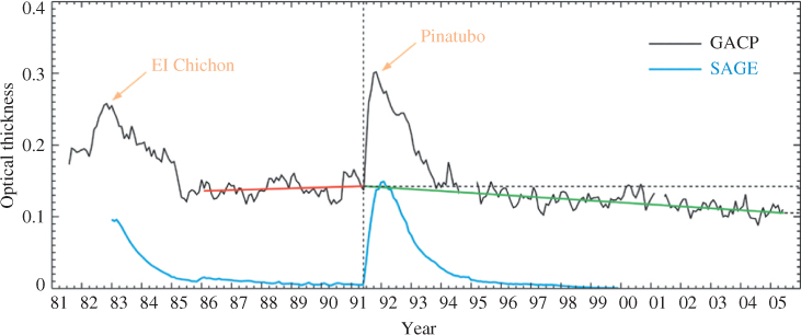
Figure 6.12 Seasonal aerosol hotspots (significant rate of increase of AOD per year) over the Indian subcontinent for the period 2000–2010. Reproduced with permission from Dey and Di Girolamo (2011). Copyright © 2011, John Wiley and Sons Ltd. See plate section for colour version.

The unique multiangle view of MISR further allows for the retrieval of aerosol plume and the tracking of its transport (Kahn et al., 2007). First, mean wind is derived at the reflecting level at coarse resolution (70.4 km). Then matching is performed between the 26° forward and nadir views and independently between the 26° backward and nadir views, using the MISR-275 m spatial resolution red-band images over each 1.1 km horizontal region. Aerosol plume height is calculated from each fore and aft pair over the entire 70.4 km domain. The natural-color nadir view of the smoke plume emitted from wildfire in Oregon is shown in Figure 6.13a. Analysis has been carried out for the five patches, with very high (in the range 0.7–1.0) AOD (Figure 6.13b) being retrieved over the region, where particles are of medium size, as suggested by the AE values (Figure 6.13c). The plume height retrieved is 5 km (Figure 6.13d). Such a dataset is important to understanding the dispersion of pollutants, which is a key input for aerosol transport models (Kahn et al., 2008; Val Martin et al., 2010).
Figure 6.13 Oregon fire, 4 September 2003, orbit 19 753, path 044, blocks 53–55, 19:00 UTC. (a) MISR nadir view of the fire plume, with five study site (patch) locations indicated as numbered white boxes, and MISR stereo-derived wind vectors superposed in yellow. (b) MISR mid-visible column AOD (version 17) retrieved at 17.6 km spatial resolution, with study site locations indicated by red arrows. There are no retrieval results for the black pixels, in most cases due to the high AOD and AOD variability of the plume core. (c) MISR-derived, column-average Angstrom exponent for the plume and surrounding area. (d) MISR stereo height product (version 13), without wind correction (labeled ‘no wind’ in the figure), for the same region. Reproduced with permission from Kahn et al. (2007). Copyright © 2007, John Wiley and Sons Ltd. See plate section for colour version.

Aerosol radiative forcing estimates have improved as a result of the better characterization of aerosol properties from satellite remote sensing (Kaufman, 2006; Yu et al., 2006, 2004). Bellouin et al. (2005) have quantified the anthropogenic fraction to total AOD using a fine-mode fraction constrained by AERONET and campaign measurements. They found the clear-sky aerosol direct radiative forcing at TOA to be −1.9 W m−2, significantly different from that predicted by climate models (−0.5 to −0.9 W m−2). Several other studies have also utilized the satellite aerosol products to reduce uncertainty in aerosol radiative forcing at regional (e.g. Elias and Roujean, 2008; Li et al., 2010; Chung et al., 2010) and global (e.g. Chung et al., 2005; Chung, Ramanathan, and Decremer, 2012; Quaas and Boucher, 2005; Christopher et al., 2006; Quaas et al., 2008) scales. The utility of satellite-based aerosol products in constraining model-based estimates of aerosol direct radiative forcing has been summarized by Yu et al. (2006).
6.3.3.2 Aerosol–Cloud–Precipitation Interaction
Satellite-based aerosol products in tandem with cloud products are also used to examine aerosol–cloud interaction, which is the largest source of uncertainty in estimating anthropogenic climate forcing. Satellites complement the paucity of in situ observations to help understand this complex problem. The satellite-based approach relies on variations in cloud macrophysical (cloud fraction and cloud-top altitude) and microphysical (phase, effective radius, and water path) properties in response to changing aerosol characteristics. Detailed studies have been carried out to examine the impacts of aerosols on clouds over the Atlantic Ocean (Kaufman et al., 2005; Koren et al., 2005; Koren, Feingold, and Remer, 2010), Amazon (Koren et al., 2008; Jones and Christopher, 2010), South Asia (Chylek et al., 2006; Tripathi, Pattnaik, and Dey, 2007; Jones, Christopher, and Quaas, 2009; Dey et al., 2011), and Africa (Loeb and Schuster, 2008; Chand et al., 2009; Su et al., 2010; Costantino and Breon, 2010) using satellite data. Satellite aerosol products have also been used to study aerosol-induced changes in precipitation (Sorooshian et al., 2009, 2010; Duong, Sorooshian, and Feingold, 2011; Koren et al., 2012). Many interesting conclusions, previously unknown, have been drawn from these studies. Notable ones include the invigoration of deep convective clouds in polluted environments and the intensification of rain, the transition from indirect to semidirect effects, and the dependence of precipitation susceptibility (i.e. change in precipitation in response to aerosol perturbation) on the cloud water path.
The aerosol–cloud relationships observed by satellites may also be attributed to passive remote sensing artifacts, codependence of aerosols and clouds on synoptic meteorology, and influence of aerosol on cloud retrieval and vice versa. Disentangling the meteorological effect on the observed cloud properties from the effect of aerosols is the most difficult task in the satellite-based approach (Lohmann, Koren, and Kuafman, 2006; Loeb and Schuster, 2008). Stevens and Feingold (2009) have reviewed the present approaches to address this critical problem and concluded that statistically meaningful relationships between aerosol, clouds, and precipitation are not always observed, due to the buffering effect of meteorology, making the problem even more difficult. They advocate treatment of individual cloud systems in order to better quantify the aerosol impact. The importance of regime-specific studies of aerosol–cloud interactions is also highlighted by Gryspeerdt and Stier (2012). Passive remote sensing artifacts involve the enhancement of AOD near clouds due to the swelling of aerosols in a humid environment, an increased number of aerosols from aerosol-generating processes, undetected sub-pixel clouds, instrument limitations, and 3D radiative interactions between clouds and surrounding clear areas (Varnai and Marshak, 2009; Redemann et al., 2009; Marshak et al., 2008; Koren et al., 2007; Wen, Marshak, and Cahalan, 2006). Quantifying the relative contributions of these factors is very difficult. Tackett and Di Girolamo (2009) have analyzed CALIPSO data to quantify the relative contribution of 3D effects on cloud-induced enhancement in AOD near cloud fields over the Caribbean Atlantic by utilizing nighttime CALIPSO data. Similar efforts are required in other regions, especially those dominated by small cumulus clouds, because cumulus clouds are typically smaller in size than the horizontal resolutions of level 2 pixels of commonly used passive sensors and may thus cause direct cloud contamination in aerosol retrieval (Myhre et al., 2004).
6.3.3.3 Applications in Air Quality
The association between air quality and human health is well established in the literature. In recent years, the paucity of ground-based observations at a global scale has led to increased utilization of satellite-based aerosol products in the study of air quality (Gupta et al., 2006; van Donkelaar et al., 2010; Brauer et al., 2012; Dey et al., 2012; Cooper et al., 2012). All these studies have converted satellite measurements of columnar AOD into surface fine particulate matter concentration (of particles smaller than 2.5 µm, PM2.5) using different approaches. The relation between columnar AOD and PM2.5 is influenced by many factors (aerosol layer thickness, scale height, cloud-free condition, composition, and meteorology) and hence any straightforward regression may be difficult to achieve. van Donkelaar et al. (2010) have utilized the GEOS-Chem model, constrained by satellite observations of columnar AOD and vertical distribution, to establish the global distribution of conversion factors. These factors account for influence on the AOD–PM2.5 relationship and are used to convert columnar AOD to PM2.5 (Figure 6.14). Global hotspots are easily identified in Figure 6.14 (e.g. the industrial areas in North America and Europe, the Indo-Gangetic Basin, the Saharan Desert, South American and Central African biomass-burning regions, West Asian dust sources, and Eastern China), where PM2.5 concentration exceeds the largest threshold (35 µg m−3) of the World Health Organization. A detailed comparison with in situ observations has revealed that these values are in fact underestimated. Dey et al. (2012), based on the analysis over the Indian subcontinent and applying the conversion factor of van Donkelaar et al. (2010) on MISR-AOD, concluded that the underestimation of MISR-PM2.5 shows a linear correlation with coincident in situ data, which allowed the bias to be corrected. The bias correction increases the correlation between satellite-based and in situ PM2.5 from 0.73 to 0.98 (Dey et al., 2012). Such approaches provide the opportunity to examine the distribution of PM2.5 at a larger spatial scale.
Figure 6.14 Global view of satellite-derived PM2.5 over land for the period 2001–2006. Reproduced from van Donkelaar et al. (2010). Copyright © 2010. This is an Open Access article. See plate section for colour version.

Hoff and Christopher (2009) have provided an excellent review of the present status of the satellite-based approaches to PM2.5 estimation and of future requirements. The spatially heterogeneous relationship between AOD and PM2.5 calls for more regional-scale analysis. The discrepancy between absolute values of AOD from various sensors is another source of uncertainty. Satellite-based estimates are biased toward clear-sky conditions, because aerosol retrieval is not possible through passive remote sensing under cloudy skies. Passive sensors onboard polar orbiting satellites provide discontinuous data (maximum once per day, because AOD is not retrieved from nighttime measurements), severely limiting their applicability in health-impact assessment. Geostationary satellites may provide continuous data at the desired temporal frequency, but limited spectral measurements might lead to larger uncertainty than the existing operational sensors. Currently, only the GOES satellite retrieves AOD at 4 km horizontal resolution at half-hourly interval, but its geographical coverage is restricted to the United States (Zhang et al., 2011). Errors in AOD retrieval propagate into the accuracy of estimated PM2.5, so an improved AOD is required, particularly in places dominated by aerosols of mixed type. The sampling gap in cloudy conditions is another concern that might be addressed by active remote sensing and the polarimetric technique of passive remote sensing (Kassianov et al., 2011).
6.4 Summary and Future Requirements
In this chapter, we have summarized the quality of current ground-based and satellite aerosol products and their applicability for studying the climatic and health impacts of aerosols. The increasing demand for new data products with global coverage for such applications has pushed remote sensing techniques to a new level in the recent years. New-generation sensors have been designed, new techniques (e.g. multiangle and multispectral views) have been adopted, and retrieval algorithms have been modified based on prior experience and the requirements of the user community. These efforts have resulted in significant improvements in our understanding of aerosol characteristics and aerosol–climate feedbacks. Improved assessments of climate models have become possible with the availability of aerosol data at higher spatial and temporal scales. Satellites have closed the data gap in developing countries and helped identify previously unknown regional hotspots.
With such promise, demand for further improvements in data quality has increased. Future missions must be planned so that these requirements can be met. Aerosol retrieval is required at high temporal (more than once a day) and spatial (∼100 m) resolutions in order to better quantify the artificial enhancement of AOD near clouds. Presently, the satellite-based aerosol product includes particle microphysical properties, along with the conventional product, AOD. However, these microphysical properties can be used qualitatively to identify major aerosol air mass. The quality of these retrieved products must be improved by updating the existing LUT with additional aerosol models. Properly planned filed campaigns may help in formulating appropriate aerosol models that can reduce the discrepancy in multisensor AOD. A unified aerosol product (combining the strengths of various sensors) would be ideal for scientific applications. Simultaneous retrieval of aerosol and cloud properties within a single pixel will further reduce the uncertainty in estimating aerosol–cloud interaction. Surface aerosol concentration (e.g. PM2.5 and particulate matters of other size categories) should be included in routine aerosol products to facilitate health-impact assessments.
Acknowledgements
The authors are thankful to the various journals for allowing the use of published materials for this chapter. The efforts of the PIs and staffs of the AERONET sites used in this study are acknowledged. SNT acknowledges financial support from project ‘Changing Water Cycle’, jointly administered by MoES, India and NERC, UK. SD acknowledge research grants from DST, Govt. of India under contract SR/FTP/ES-191/2010 and DST/CCP/PR/11/2011 through research projects operational at IIT Delhi (IITD/IRD/RP02509 and IITD/IRD/RP2580).
References
Abdi Vishkaee, F., Flamant, C., Cuesta, J. et al. (2012) Dust transport over Iraq and northwest Iran associated with winter Shamal: a case study. Journal of Geophysical Research, 117, D03201.
Ackerman, S., Strabala, K., Menzel, W. et al. (1998) Discriminating clear sky from clouds with MODIS. Journal of Geophysical Research, 103(D24), 32141–32157.
Ackerman, A.S., Toon, O.B., Stevens, D.E. et al. (2000) Reduction of tropical cloudiness by soot. Science, 288, 1042–1047.
Albrecht, B.A. (1989) Aerosols, cloud microphysics, and fractional cloudiness. Science, 245, 1227–1230.
Andreae, M.O. and Rosenfeld, D. (2008) Aerosol-cloud-precipitation interactions. Part 1. The nature and sources of cloud-active aerosols. Earth-Science Reviews, 89, 13–41.
Arola, A., Schuster, G., Myhre, G. et al. (2011) Inferring absorbing organic carbon content from AERONET data. Atmospheric Chemistry and Physics, 11, 215–225.
Bellouin, B., Boucher, O., Haywood, J. and Reddy, M.S. (2005) Global estimates of aerosol direct radiative forcing from satellite measurements. Nature, 438, 1138–1140.
Boucher, O. and Pham, M. (2002) History of sulfate aerosol radiative forcings. Geophysical Research Letters, 29(9), 1308. doi: 10.1029/2001GL014048.
Brauer, M., Amman, M., Burnett, R.T. et al. (2012) Exposure assessment for estimation for the global burden of disease attributable to outdoor air pollution. Environmental Science and Technology, 46(2), 652–660.
Brav, W.J. (1929) Aerosols—clouds, dust, fog and smoke. Journal of Chemical Education, 6(9), 1497–1502.
Cabello, M., Orza, J.A.G., Barrero, M.A. et al. (2012) Spatial and temporal variation of the impact of an extreme Saharan dust event. Journal of Geophysical Research, 117, D11204.
Campbell, J.R., Tackett, J.L., Reid, J.S. et al. (2012) Evaluating nighttime CALIOP 0.532 µm aerosol optical depth and extinction coefficient retrievals. Atmospheric Measurement Techniques, 5, 2143–2160.
Chand, D., Wood, R., Anderson, T.L. et al. (2009) Satellite-derived direct radiative effect of aerosols dependent on cloud cover. Nature Geoscience, 2, 181–184.
Charlson, R.J. and Pilat, M.J. (1969) Climate: the influence of aerosols. Journal of Applied Meteorology, 8, 1001–1002.
Charlson, R.J., Schwartz, S.E., Hales, J.H. et al. (1992) Climate forcing by anthropogenic aerosols. Science, 255, 423–430.
Chen, Y., Liu, Q., Geng, F. et al. (2012) Vertical distribution of optical and micro-physical properties of ambient aerosols during dry haze periods in Shanghai. Atmospheric Environment, 50, 50–59.
Chow, J.C. and Watson, J.G. (2007) Review of measurement methods and compositions for ultrafine particles. Aerosol and Air Quality Research, 7(2), 121–173.
Christopher, S.A., Zhang, J., Kuafman, Y.J. and Remer, L.A. (2006) Satellite-based assessment of top of atmosphere amthropogenic aerosol radiative forcing over cloud free oceans. Geophysical Research Letters, 33, L15816.
Chung, C.E., Ramanathan, V., Carmichael, G. et al. (2010) Anthropogenic aerosol radiative forcing in Asia derived from regional models with atmospheric ad aerosol data assimilation. Atmospheric Chemistry and Physics, 10, 6007–6024.
Chung, C.E., Ramanathan, V. and Decremer, D. (2012) Observationally constrained estimates of carbonaceous aerosol radiative forcing. Proceedings of the National Academy of Sciences, 109(29), 11624–11629.
Chung, C.E., Ramanathan, V., Kim, D. and Podgorny, I.A. (2005) Global anthropogenic aerosol direct forcing derived from satellite and ground-based observations. Journal of Geophysical Research, 110, D24207.
Chylek, P., Dubey, M.K., Lohmann, U. et al. (2006) Aerosol indirect effect over the Indian Ocean. Geophysical Research Letters, 33, L06806.
Chylek, P. and Wong, J. (1995) Effect of absorbing aerosol on global radiation budget. Geophysical Research Letters, 22, 929–931.
Cooper, M.J., Martin, R.V., van Donkelaar, A. et al. (2012) A satellite-based multi-pollutant index of global air quality. Environmental Science and Technology, 46(12), 8523–8524.
Costantino, L. and Breon, F.M. (2010) Analysis of aerosol-cloud interaction from multisensory satellite observations. Geophysical Research Letters, 37, L11801.
Dey, S. and Di Girolamo, L. (2010) A climatology of aerosol optical and microphysical properties over the Indian subcontinent from 9 years (2000–2008) of Multiangle Imaging SpectroRadiometer (MISR) data. Journal of Geophysical Research, 115, D15204.
Dey, S. and Di Girolamo, L. (2011) A decade of change in aerosol properties over the Indian subcontinent. Geophysical Research, 38, L14811.
Dey, S., Di Girolamo, L., van Donkelaar, A. et al. (2012) Variability of outdoor fine particulate (PM2.5) concentration in the Indian subcontinent: a remote sensing approach. Remote Sensing of Environment, 127, 153–161.
Dey, S., Di Girolamo, L., Zhao, G. et al. (2011) Satellite-observed relationships between aerosol and trade-wind cumulus cloud properties over the Indian Ocean. Geophysical Research Letters, 38, L01804.
Dey, S., Tripathi, S.N. and Mishra, S.K. (2008) Probable mixing state of aerosols in the Indo-Gangetic Basub, Northern India. Geophysical Research Letters, 35, L03808.
Dey, S., Tripathi, S.N., Singh, R.P. and Holben, B.N. (2004) Influence of the dust storms on the aerosol optical properties over the Indo-Gangetic Basin. Journal of Geophysical Research, 109, D20122.
Dey, S., Tripathi, S.N., Singh, R.P. and Holben, B.N. (2006) Retrieval of black carbon and specific absorption over Kanpur city, Northern India during 2001–2003. Atmospheric Environment, 40(3), 445–456.
Diner, D.J., Beckert, J.C., Reilly, T.H. et al. (1998) Multi-angle Imaging SpectroRadiometer (MISR) instrument description and experiment overview. IEEE Transactions on Geoscience and Remote Sensing, 36, 1072–1087.
Di Pierro, M., Jaegle, L. and Anderson, T.L. (2011) Satellite observations of aerosol transport from East Asia to the Arctic: three case studies. Atmospheric Chemistry and Physics, 11, 2225–2243.
van Donkelaar, A., Martin, R.V., Brauer, M. et al. (2010) Global estimates of ambient fine particulate matter concentrations from satellite-based aerosol optical depth: development and application. Environmental Health Perspectives, 118(6), 847–855.
Dubovik, O., Holben, B.N., Eck, T.F. et al. (2002) Variability of absorption and optical properties of key aerosol types observed in worldwide locations. Journal of the Atmospheric Sciences, 59, 590–608.
Dubovik, O. and King, M.D. (2000) A flexible inversion algorithm for retrieval of aerosol properties from sun and sky radiance measurements. Journal of Geophysical Research, 105, 20673–20696.
Dubovik, O., Smirnov, A., Holben, B.N. et al. (2000) Accuracy assessments of aerosol optical properties retrieved from Aerosol Robotic Network (AERONET) sun and sky radiance measurements. Journal of Geophysical Research: Atmospheres, 105(D8), 9791–9806.
Duong, H.T., Sorooshian, A. and Feingold, G. (2011) Investigating potential biases in observed and modeled metrics of aerosol-cloud-precipitation interactions. Atmospheric Chemistry and Physics, 11, 4027–4037.
Eck, T.F., Holben, B.N., Sinyuk, A. et al. (2010) Climatological aspects of the optical properties of fine/coarse mode aerosol mixtures. Journal of Geophysical Research, 115, D19205.
Elias, T. and Roujean, J.L. (2008) Estimation of the aerosol radiative forcing at ground level, over land, and in cloudless atmosphere, from METEOSAT-7 observation: method and case study. Atmospheric Chemistry and Physics, 8, 625–636.
Geogdzhayev, I.V., Mishchenko, M.I., Liu, L. and Remer, L. (2004) Global two-channel AVHRR aerosol climatology: effects of stratospheric aerosols and preliminary comparisons with MODIS and MISR retrievals. Journal of Quantitative Spectroscopy and Radiative Transfer, 88, 47–59.
Geogdzhayev, I.V., Mishchenko, M.I., Rossow, W.B. et al. (2002) Global two-channel AVHRR retrievals of aerosol properties over the ocean for the period of NOAA-9 observations and preliminary retrievals using NOAA-7 and NOAA-11 data. Journal of the Atmospheric Sciences, 59, 262–278.
Geogdzhayev, I.V., Mishchenko, M.I., Terez, E.I. et al. (2005) Regional advanced very high resolution radiometer-derived climatology of aerosol optical thickness and size. Journal of Geophysical Research, 110, D23205.
Giles, D.M., Holben, B.N., Eck, T.F. et al. (2012) An analysis of AERONET aerosol absorption properties and classifications representative of aerosol source regions. Journal of Geophysical Research, 117, D17203.
Gleason, J.F., Hsu, N.C. and Torres, O. (1998) Biomass burning smoke measured using backscattered ultraviolet radiation: SCAR-B and Brazilian smoke interannual variability. Journal of Geophysical Research, 103, 31969–31978.
Gobbi, G.P., Kaufman, Y.J., Koren, I. and Eck, T.F. (2007) Classification of aerosol properties derived from AERONET direct sun data. Atmospheric Chemistry and Physics, 7, 453–458.
Griggs, M. (1975) Measurements of atmospheric aerosol optical thickness over water using ERTS-1 data. Journal of the Air Pollution Control Association, 25, 622–626.
Gryspeerdt, E. and Stier, P. (2012) Regime-based aerosol-cloud interactions. Geophysical Research Letters, 39(21).
Gupta, P., Christopher, S.A., Wang, J. et al. (2006) Satellite remote sensing of particulate matter and air quality over global cities. Atmospheric Environment, 40, 5880–5892.
Hansen, J., Sato, M. and Ruedy, R. (1997) Radiative forcing and climate response. Journal of Geophysical Research, 102, 6831–6864.
Hao, W.M. and Liu, M.H. (1994) Spatial and temporal distribution of tropical biomass burning. Global Biogeochemical Cycles, 8, 495–503.
Haywood, J. and Boucher, O. (2000) Estimates of the direct and indirect radiative forcing due to tropospheric aerosols: a review. Reviews of Geophysics, 38(4), 513–543.
Herman, J.R. and Celarier, E.A. (1997) Earth surface reflectivity climatology at 340–380 nm from TOMS data. Journal of Geophysical Research, 102, 28003–28012.
Hoff, R.M. and Christopher, S. (2009) Remote sensing of particulate pollution from space: have we reached the promised land? Journal of the Air and Waste Management Association, 59, 645–675.
Holben, B.N., Eck, T.F., Slutsker, I. et al. (1998) AERONET-A federated instrument network and data archive for aerosol characterization. Remote Sensing of Environment, 66, 1–16.
Holben, B.N., Tanré, D., Smirnov, A. et al. (2001) An emerging ground-based aerosol climatology: aerosol optical depth from AERONET. Journal of Geophysical Research, 106, 12067–12097.
IPCC (2007) Changes in atmospheric constituents and in radiative forcing, in Climate Change 2007: The Physical Science Basis, Contribution of Working Group I to the Fourth Assessment Report of the Intergovernmental Panel on Climate Change (eds S. Solomon, D. Qin, M. Manning et al.), Cambridge University Press.
Johnson, B.T., Shine, K.P. and Forster, P.M. (2004) The semi-direct aerosol effect: impact of absorbing aerosols on marine stratocumulus. Quarterly Journal of the Royal Meteorological Society, 130, 1407–1422.
Jones, T.A. and Christopher, S.A. (2010) Statistical properties of aerosol-cloud-precipitation interactions in South America. Atmospheric Chemistry and Physics, 10, 2287–2305.
Jones, T.A., Christopher, S. and Quaas, J. (2009) A six year satellite-based assessment of the regional variations in aerosol indirect effects. Atmospheric Chemistry and Physics, 9, 4091–4114.
Kahn, R.A., Chen, Y., Nelson, D.L. et al. (2008) Wildfire smoke injection heights: two perspectives from space. Geophysical Research Letters, 35, L04809.
Kahn, R.A., Gaitley, B.J., Garay, M.J. et al. (2010) Multiangle imaging spectroradiometer global aerosol product assessment by comparison with the aerosol robotic network. Journal of Geophysical Research, 115, D23209.
Kahn, R.A., Gaitley, B., Martonchik, J. et al. (2005) MISR global aerosol optical depth validation based on two years of coincident AERONET observations. Journal of Geophysical Research, 110, D10S04.
Kahn, R.A., Garay, M.J., Nelson, D.L. et al. (2011) Response to ‘Towards unified satellite climatology of aerosol properties: 3. MODIS versus MISR versus AERONET’. Journal of Quantitative Spectroscopy and Radiative Transfer, 112, 901–909.
Kahn, R.A., Li, W.H., Moroney, C. et al. (2007) Aerosol source plume physical characteristics from space-based multiangle imaging. Journal of Geophysical Research, 112, D11205.
Kahn, R.A., Nelson, D.L., Garay, M. et al. (2009) MISR aerosol product attributes, and statistical comparisons with MODIS. IEEE Transactions on Geoscience and Remote Sensing, 47(12), 4095–4114.
Kalashnikova, O.V. and Kahn, R.A. (2008) Mineral dust plume evolution over the Atlantic from combined MISR/MODIS aerosol retrievals. Journal of Geophysical Research, 113, D24204. doi: 10.1029/2008JD010083.
Kalashnikova, O.V., Kahn, R., Sokolik, I.N. and Li, W.H. (2005) Ability of multiangle remote sensing observations to identify and distinguish mineral dust types: optical models and retrievals of optically thick plumes. Journal of Geophysical Research: Atmospheres, 110(D18).
Kaskaoutis, D.G., Kalapureddy, M.C.R., Moorthy, K.K. et al. (2010) Heterogeneity in pre-monsoon aerosol types over the Arabian Sea deduced from ship-borne measurements of spectral AODs. Atmospheric Chemistry and Physics, 10, 4893–4908.
Kassianov, E., Ovchinnikov, M., Berg, L.K. and Flynn, C. (2011) Aerosol retrievals under partly cloudy conditions: challenges and perspectives, in Polarimetric Detection, Characterization and Remote Sensing (eds M.I. Mishchenko, Y.S. Yatskiv, V.K. Rosenbush and G. Videen), Springer, Dordrecht, pp. 205–232.
Kaufman, Y.J. (2006) Satellite observations of natural and anthropogenic aerosol effects on clouds and climate. Space Science Reviews, 125, 139–147.
Kaufman, Y.J., Koren, I., Remer, L.A. et al. (2005) The effect of smoke, dust and pollution aerosol on shallow cloud development over the Atlantic Ocean. Proceedings of the National Academy of Sciences, 102(32), 11207–11212.
Kaufman, Y.J., Tanre, D. and Boucher, O. (2000) A satellite view of aerosols in the climate system. Nature, 419, 215–223.
Kaufman, Y.J., Wald, A., Remer, L. et al. (1997) The MODIS 2.1 µm channel—correlation with visible reflectance for use in remote sensing of aerosol. IEEE Transactions on Geoscience and Remote Sensing, 35(5), 1286–1298.
Kedia, S. and Ramachandran, S. (2009) Variability in aerosol optical and physical characteristics over the Bay of Bengal and the Arabian Sea deduced from Angstrom exponents. Journal of Geophysical Research, 114, D14207.
Kishcha, P., Starobinets, B., Kalashnikova, O. and Alpert, P. (2011) Aerosol optical thickness trends and population growth in the Indian subcontinent. International Journal of Remote Sensing, 32(24), 9137–9149.
Koffi, B., Schulz, M., Bréon, F.M., Griesfeller, J., Winker, D.M., Balkanski, Y., Bauer, S., Berntsen, T., Chin, M., Collins, W.D., Dentener, F., Diehl, T., Easter, R.C., Ghan, S.J., Ginoux, P.A., Gong, S., Horowitz, L.W., Iversen, T., Kirkevag, A., Koch, D.M., Krol, M., Myhre, G., Stier, P., and Takemura, T. (2012) Application of the CALIOP layer product to evaluate the vertical distribution of aerosols estimated by global models: part 1. AeroCom phase I results, Journal of Geophysical Research, 117, D10201.
Koren, I., Altaratz, O., Remer, L.A. et al. (2012) Aerosol induced intensification of rain from the tropics to the mid-latitudes. Nature Geoscience, 5, 118–122.
Koren, I., Feingold, G. and Remer, L.A. (2010) The invigoration of deep convective clouds over the Atlantic: aerosol effect, meteorology or retrieval artifact? Atmospheric Chemistry and Physics, 10, 8855–8872.
Koren, I., Kaufman, Y.J., Remer, L.A. and Martins, J.V. (2004) Measurement of the effect of Amazon smoke on inhibition of cloud formation. Science, 303, 1342–1345.
Koren, I., Kaufman, Y.J., Rosenfeld, D., Remer, L.A., and Rudich, Y. (2005) Aerosol invigoration and restructuring of Atlantic convective clouds, Geophysical Research Letters, 32, L14828.
Koren, I., Martins, J.V., Remer, L.A. and Afargan, H. (2008) Smoke invigoration versus inhibition of clouds over the Amazon. Science, 321(5891), 946–949.
Koren, I., Remer, L.A., Kaufman, Y.J. et al. (2007) On the twilight zone between clouds and aerosols. Geophysical Research Letters, 34, L08805.
Koven, C.D. and Fung, I. (2006) Inferring dust composition from wavelength-dependent absorption in Aerosol Robotic Network (AERONET) data. Journal of Geophysical Research: Atmospheres, 111(D14), D14205.
Kumari, B.P., Londhe, A.L., Daniel, S. and Jadhav, D.B. (2007) Observational evidence of solar dimming: offsetting surface warming over India. Geophysical Research Letters, 34, L21810.
Lee, J., Kim, J., Song, C.H. et al. (2010) Characteristics of aerosol types from AERONET sunphotometer measurements. Atmospheric Environment, 44, 3110–3117.
Lee, K.H., Li, Z., Kim, J., and Kokhanosky, A. (2009) Atmospheric aerosol monitoring from satellite observations: a history of three decades, in Atmospheric and Biological Environmental Monitoring, (eds Y.J. Kim, U. Platt, M.B. Gu, and H. Iwahashi), Springer, pp. 13–38.
Lelieveld, J., Berresheim, H., Borrmann, S. et al. (2002) Global air pollution crossroads over the Mediterranean. Science, 298, 794–799.
Levy, R.C., Leptoukh, G.G., Kahn, R. et al. (2009) A critical look at the deriving monthly aerosol optical depth from satellite data. IEEE Transactions on Geoscience and Remote Sensing, 47(8), 2942–2956.
Levy, R.C., Remer, L.A. and Dubovik, O. (2007) Global aerosol optical properties and application to moderate resolution imaging spectroradiometer aerosol retrieval over land. Journal of Geophysical Research, 112, D13210.
Levy, R.C., Remer, L.A., Kleidman, R.G. et al. (2010) Global evaluation of the collection 5 MODIS dark-target aerosol products over land. Atmospheric Chemistry and Physics, 10, 10399–10420.
Li, Z., Lee, K.H., Wang, Y. et al. (2010) First observation-based estimates of cloud-free aerosol radiative forcing across China. Journal of Geophysical Research, 115, D00K18.
Li, Z., Zhao, X., Kahn, R. et al. (2009) Uncertainties in satellite remote sensing of aerosols and impact on monitoring its long-term trend: a review and perspective. Annals of Geophysics, 27, 2755–2770.
Liu, D.Z., Liu, Z., Winker, D. and Trepte, C. (2008) A height resolved global view of dust aerosols from the first year of CALIPSO lidar measurements. Journal of Geophysical Research, 113, D16214.
Liu, L. and Mishchenko, M.I. (2008) Toward unified satellite climatology of aerosol properties: direct comparisons of advanced level 2 aerosol products. Journal of Quantitative Spectroscopy and Radiative Transfer, 109(14), 2376–2385.
Liu, Y., Wang, Z., Wang, J. et al. (2011a) The effect of aerosol vertical profiles on satellite-estimated surface particle sulfate concentrations. Remote Sensing of Environment, 115, 508–513.
Liu, J., Zheng, Y., Li, Z. et al. (2011b) Transport, vertical structure and radiative properties of dust events in Southeast China determined from ground and space sensors. Atmospheric Environment, 45, 6469–6480.
Loeb, N.G. and Schuster, G.L. (2008) An observational study of the relationship between cloud, aerosol and meteorology in broken low-level cloud conditions. Journal of Geophysical Research: Atmospheres, 113(D14).
Lohmann, U. and Feichter, J. (2005) Global indirect aerosol effects: a review. Atmospheric Chemistry and Physics, 5, 715–737.
Lohmann, U., Koren, I. and Kuafman, Y.J. (2006) Disentangling the role of microphysical and dynamical effects in determining cloud properties over the Atlantic. Geophysical Research Letters, 33, L09802.
Mahowald, N.M. and Dufresne, J.L. (2004) Sensitivity of TOMS aerosol index to boundary layer height: implications for detection of mineral aerosol sources. Geophysical Research Letters, 31, L03103.
Marey, H.S., Gille, J.C., El-Askary, H.M. et al. (2011) Aerosol climatology over Nile delta based on MODIS, MISR and OMI satellite data. Atmospheric Chemistry and Physics, 11, 10637–10648.
Marshak, A., Wen, G., Coakley, J.A. Jr. et al. (2008) A simple model for the cloud adjacency effect and the apparent bluing of aerosols near clouds. Journal of Geophysical Research, 113, D14S17.
Massie, S.T., Torres, O. and Smith, S.J. (2004) Total Ozone Mapping Spectrometer (TOMS) observations of increases in Asian aerosol in winter from 1979 to 2000. Journal of Geophysical Research, 109, D18211.
McPeters, R.D., Hollandsworth, S.M., Flynn, L.E. et al. (1996) Long-term ozone trends derived from the 16-year combined Nimbus 7/Meteor 3 TOMS Version 7 record. Geophysical Research Letters, 25, 3699–3702.
Mishchenko, M.I., Geogdzhayev, I.A., Cairns, B. et al. (2007a) Past, present, and future of global aerosol climatologies derived from satellite observations: a perspective. Journal of Quantitative Spectroscopy and Radiative Transfer, 106, 325–347.
Mishchenko, M.I., Geogdzhayev, I.A., Rossow, W.B. et al. (2007b) Long-term satellite record reveals likely recent aerosol trend. Science, 315(5818), 1543.
Mishchenko, M.I., Geogdzhayev, I.V., Cairns, B. et al. (1999) Aerosol retrievals over the ocean by use of channels 1 and 2 AVHRR data: sensitivity analysis and preliminary results. Applied Optics, 38, 7325–7341.
Mishchenko, M.I., Geogdzhayev, I.V., Liu, L. et al. (2009) Toward unified satellite climatology of aerosol properties: what do fully compatible MODIS and MISR aerosol pixels tell us? Journal of Quantitative Spectroscopy and Radiative Transfer, 110, 402–408.
Mishchenko M.I., Liu, L., Geogdzhayev, I.V., et al. (2012) Aerosol retrievals from channel-1 and -2 AVHRR radiances: long-term trends updated and revisited, Journal of Quantitative Spectroscopy and Radiative Transfer, 113, 1974–1980, http://dx.doi.org/10.1016/j.jqsrt.2012.05.006 (accessed 13 July 2013).
Mishra, A.K. and Shibata, T. (2012) Climatological aspects of seasonal variation of aerosol vertical distribution over central Indo-Gangetic belt (IGB) inferred by the space-borne lidar CALIOP. Atmospheric Environment, 46, 365–375.
Mishra, S.K. and Tripathi, S.N. (2008) Modeling optical properties of mineral dust over the Indian Desert. Journal of Geophysical Research, 113, D23201.
Mishra, S.K., Tripathi, S.N., Aggarwal, S.G. and Arola, A. (2012) Optical properties of accumulation mode polluted mineral dust: effects of particle shape, hematite content and semi-external mixing with carbonaceous species. Tellus, 64B, 18536.
Misra, A., Tripathi, S.N., Kaul, D.S. and Welton, E.J. (2012) Study of MPLNET-derived aerosol climatology over Kanpur, India, and validation of CALIPSO level 2 version 3 backscatter and extinction products. Journal of Atmospheric and Oceanic Technology, 29, 1285–1294.
Moorthy, K.K., Babu, S.S. and Satheesh, S.K. (2007) Temporal heterogeneity in aerosol characteristics and the resulting radiative impact at a tropical coastal station—Part 1: microphysical and optical properties. Annals of Geophysics, 25, 2293–2308.
Myhre, G., Stordal, F., Johnsrud, M. et al. (2004) Intercomparison of satellite retrieved aerosol optical depth over ocean. Journal of the Atmospheric Sciences, 61, 499–513.
Myhre, G., Stordal, F., Johnsrud, M. et al. (2005) Intercomparison of satellite retrieved aerosol optical depth over ocean during the period September 1997 to December 2000. Atmospheric Chemistry and Physics, 5, 1697–1719.
Prospero, J.M., Ginoux, P., Torres, O. et al. (2002) Environmental characterization of global sources of atmospheric soil dust identified with the Nimbus 7 Total Ozone Mapping Spectrometer (TOMS) absorbing aerosol product. Reviews of Geophysics, 40(1). doi: 10.1029/2000RG000095.
Quaas, J. and Boucher, O. (2005) Constraining the first aerosol indirect radiative forcing in the LMDZ GCM using POLDER and MODIS satellite data. Geophysical Research Letters, 32, L17814.
Quaas, J., Boucher, O., Bellouin, N. and Kinne, S. (2008) Satellite-based estimate of the direct and indirect aerosol climate forcing. Journal of Geophysical Research, 113, D05204.
Ramachandran, S. and Cherian, R. (2008) Regional and seasonal variations in aerosol optical characteristics and their frequency distributions over India during 2001–2005. Journal of Geophysical Research, 111, D20207.
Ramanathan, V., Crutzen, P.J., Kiehl, J.L. and Rosenfeld, D. (2001) Aerosols, climate, and the hydrological cycle. Science, 294, 2119–2124.
Redemann, J., Zhang, Q., Russel, P.B. et al. (2009) Case studies of aerosol remote sensing in the vicinity of clouds. Journal of Geophysical Research, 114, D06209.
Remer, L.A., Kaufman, Y.J., Tanre, D. et al. (2005) The MODIS aerosol algorithm, products and validation. Journal of the Atmospheric Sciences, 62, 947–972.
Remer, L.A., Kleidman, R.G., Levy, R.C. et al. (2008) Global aerosol climatology from the MODIS satellite sensors. Journal of Geophysical Research, 113, D14S07.
Schuster, G.L., Dubovik, O. and Holben, B.N. (2006) Angstrom exponent and bimodal size distributions. Journal of Geophysical Research, 111, D07207.
Schuster, G.L., Dubovik, O., Holben, B.N. and Clothiaux, E.E. (2005) Inferring black carbon content and specific absorption from Aerosol Robotic Network (AERONET) aerosol retrievals. Journal of Geophysical Research, 110, D10S17.
Smirnov, A., Holben, B.N., Slutsker, I., et al. (2009) Maritime aerosol network as a component of aerosol robotic network, Journal of Geophysical Research, 114, D06204.
Sorooshian, A., Feingold, G., Lebsock, M.D. et al. (2009) On the precipitation susceptibility of clouds to aerosol perturbations. Geophysical Research Letters, 36, L13803.
Sorooshian, A., Feingold, G., Lebsock, M.D. et al. (2010) Deconstructing the precipitation susceptibility construct: improving metholodology for aerosol-cloud precipitation studies. Journal of Geophysical Research, 115, D17201.
Srivastava, A.K., Tripathi, S.N., Dey, S. et al. (2012) Inferring aerosol types over the Indo-Gangetic Basin from ground based sunphotometer measurements. Atmospheric Research, 109, 64–75.
Stephens, G.L., Vane, D.G., Boain, R.J. et al. (2002) The CloudSat mission and the A-Train: a new dimension of space-based observations of clouds and precipitation. Bulletin of the American Meteorological Society, 83, 1771–1790.
Stevens, B. and Feingold, G. (2009) Untangling aerosol effects on clouds and precipitation in a buffered system. Nature, 461, 607–613.
Stowe, L.L., Jacobowitz, H., Ohring, G. et al. (2002) The Advanced Very High Resolution Pathfinder Atmosphere (PATMOS) climate dataset: initial analysis and evaluations. Journal of Climate, 15, 1243–1260.
Su, W., Loeb, N.G., Xu, K.M. et al. (2010) An estimate of aerosol indirect effect from satellite measurements with concurrent meteorological analysis. Journal of Geophysical Research, 115, D18219.
Tackett, J.L. and Di Girolamo, L. (2009) Enhanced aerosol backscatter adjacent to tropical trade wind clouds revealed by satellite-based lidar. Geophysical Research Letters, 36, L14804.
Torres, O., Bhartia, P.K., Herman, J.R. et al. (1998) Derivation of aerosol properties from satellite measurements of back-scattered ultraviolet radiation: theoretical basis. Journal of Geophysical Research, 103, 17,099–17,110.
Torres, O., Bhartia, P.K., Herman, J.R. et al. (2002) A long-term record of aerosol optical depth from TOMS observations and comparison to AERONET measurements. Journal of the Atmospheric Sciences, 59, 398–413.
Tripathi, S.N., Pattnaik, A. and Dey, S. (2007) Aerosol indirect effect over the Indo-Gangetic plain. Atmospheric Environment, 41(33), 7037–7047.
Twomey, S. (1977) The influence of pollution on the shortwave albedo of clouds. Journal of the Atmospheric Sciences, 34(7), 1149–1152.
Val Martin, M., Logan, J.A., Kahn, R. et al. (2010) Smoke injection heights from fires in North America: analysis of five years of satellite observations. Atmospheric Chemistry and Physics, 10, 1491–1510.
Varnai, T. and Marshak, A. (2009) MODIS observations of enhanced clear sky reflectance near clouds. Geophysical Research Letters, 36, L06807.
Welton, E.J. and Campbell, J.R. (2002) Micropulse lidar signals: uncertainty analysis. Journal of Atmospheric and Oceanic Technology, 19, 2089–2094.
Welton, E.J., Campbell, J.R., Spinhirne, J.D. and Scott, V.S. (2001) Global monitoring of clouds and aerosols using a network of micro-pulse lidar systems. Proceedings of SPIE, 4153, 151–158.
Welton, E.J., Voss, K.J., Gordon, H.R. et al. (2000) Ground-based lidar measurements of aerosols during ACE-2: instrument description, results, and comparisons with other ground-based and airborne measurements. Tellus, 52B, 636–651.
Welton, E.J., Voss, K.J., Quinn, P.K. et al. (2002) Measurements of aerosol vertical profiles and optical properties during INDOEX 1999 using micropulse lidars. Journal of Geophysical Research, 107(D19), 8019.
Wen, G., Marshak, A. and Cahalan, R.F. (2006) Impact of 3D clouds on clear sky reflectance and aerosol retrieval in a biomass burning region of Brazil. IEEE Geoscience and Remote Sensing Letters, 3, 169–172.
Wild, M., Gilgen, H., Roesch, A. et al. (2005) From dimming to brightening: decadal changes in solar radiation at Earth's surface. Science, 308(5723), 847–850.
Xia, X.G., Wang, P., Wang, Y., et al. (2008) Aerosol optical depth over the Tibetan Plateau and its relation to aerosols over the Taklimakan desert, Geophysical Research Letters, 35(16), L16804.
Yu, H., Dickinson, R.E., Chin, M., Kaufman, Y.J., Zhou, M., Zhou, L., Tian, Y., Dubovik, O., and Holben, B.N. (2004) Direct radiative effect of aerosols as determined from a combination of MODIS retrievals and GOCART simulations, Journal of Geophysical Research, 109, D03206.
Yu, H., Kaufman, Y.J., Chin, M. et al. (2006) A review of measurement-based assessments of the aerosol direct radiative effect and forcing. Atmospheric Chemistry and Physics, 6, 613–666.
Zhang, H., Lyapustin, A., Wang, Y. et al. (2011) A multi-angle aerosol optical depth retrieval algorithm for geostationary satellite over the United States. Atmospheric Chemistry and Physics, 11, 11977–11991.