Experience More
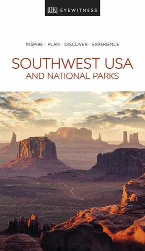
t A car on the Sandia Peak Tramway overlooking the stunning Rio Grande valley
The Sandia Peak Tramway is a breathtaking ride from the foothills of northeastern Albuquerque to Sandia Peak. The tram was constructed in the mid-1960s, and carries you to the summit’s viewing platform. The 15-minute ride passes through desert, pon-derosa pine forests, and mountains, with outstanding views of Albuquerque and the surrounding landscape.

Hidden Gem
El Malpais National Monument
The dramatic lava flows, cinder cones, and lava tube caves make the volcanic landscape of El Malpais (“The Badlands” in Spanish) a fascinating place to explore. Stop at the visitor center near Grants for information.
Between the 1950s and the 1980s, Grants was famous as a center for uranium mining. The mineral was found in 1951 by Navajo farmer Paddy Martinez on top of Haystack Mountain, 10 miles (16 km) from town. The industry has now declined, but visitors can relive its heyday at the New Mexico Mining Museum; the tours go underground to see a re-created mine.
Grants is well placed along Highway 40/Route 66 for exploring the area, including the badlands of El Malpais National Monument.
" '
New Mexico Mining Museum
⌂ 100 Iron Ave # 9am– 4pm Mon–Sat ¢ Public hols
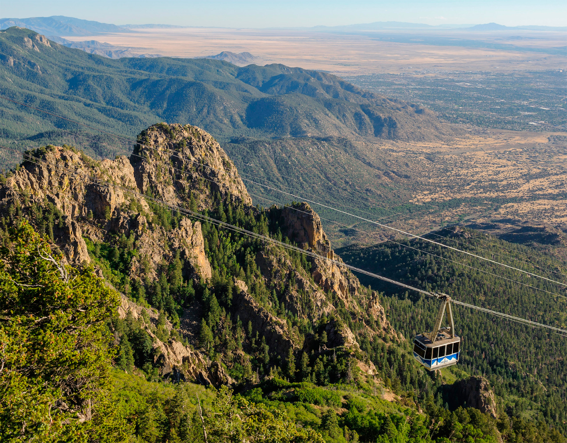
t Acoma Pueblo, or Sky City, perched on top of the mesa
The incredible beauty of Acoma Pueblo’s setting on the top of a 357-ft- (107-m-) high mesa has earned it the sobriquet “Sky City.” Looking out over a stunning panorama of distant mountains, mesas, and plains, it gave the Puebloans a natural defense against enemies and helped delay submission to Spanish rule. Acoma is one of the oldest continuously inhabited towns in the US, occupied since before the 12th century. Today, fewer than 30 people live on the mesa top year round; 6,000 others from local towns return to their ancestral home for festivals and celebrations.
As well as original pueblo buildings, the village has a 1629 mission church, San Esteben del Rey. There are also seven ceremonial kivas. Acoma can be visited only on a guided tour (arranged at the Sky City Cultural Center and Haak’u Museum), where expert guides explain its rich history.
" ' - =
Sky City Cultural Center and Haak’u Museum
⌂ Base of the mesa # Mid-Mar–Oct: 9am–5pm daily; Nov–mid-Mar: 9am–4pm Fri–Sun ∑ acomaskycity.org
This small farming community was settled by the Spanish in 1698. Here, against a striking backdrop on the banks of the Rio Grande, is the Coronado Historic Site, which encompasses the partially restored ruins of the Kuaua Pueblo. Spanish explorer Francisco Vázquez de Coronado is believed to have been here in 1540 seeking the fabled cities of gold.
Nearby Sandia Pueblo is home to some 300 people, who take part in tribal dancing on San Antonio’s Day in June.
Around 16 miles (25 km) northwest of Bernaillo, Zia Pueblo is famous for its redware pottery. Visitors are welcome to buy the pottery and woven baskets made in this small community.
"
Coronado Historic Site
⌂ 485 Kuaua Rd # 8:30am–5pm Wed–Mon ¢ Jan 1, Easter, Thanksgiving, Dec 25 ∑ nmhistoricsites.org/coronado
Rising dramatically from the surrounding plain, El Morro is a long sandstone cliff that slopes gently upward to a high bluff, where it suddenly drops off. Its centerpiece is the 200-ft- (61-m-) tall Inscription Rock, which is covered with more than 300 petroglyphs and pictographs from early Pueblo people, as well as the thousands of inscriptions left by Spanish and Anglo travelers.
For centuries people were drawn to this remote spot by a pool of fresh water, formed by runoff and snowmelt. Here they carved their initials into the rock. Among the signatures is that of the Spanish colonizer Juan de Oñate, who, in 1605, wrote “pasó por aquí,” meaning “I passed by here.” An easy half-mile (1-km) trail leads past the pool and the inscriptions on the rock.
The people of Zuni Pueblo, 32 miles (51 km) west of El Morro, are the descendants of the early mesa dwellers of the region. Today, Zuni artists are known for their fine pottery and jewelry. Murals depicting Zuni history can be seen in the pueblo’s 17th-century mission church.
Zia Sun Symbol
The distinctive red Zia sun symbol, which was adopted in 1925 by the state of New Mexico and is used on the state flag and license plate, originated in Zia Pueblo in ancient times. The symbol has sacred meaning to the Zia. It symbolizes the circle of life – the four seasons, the four cardinal dir-ections, the four per-iods of each day, and the four seasons of life – bound together by a circle.

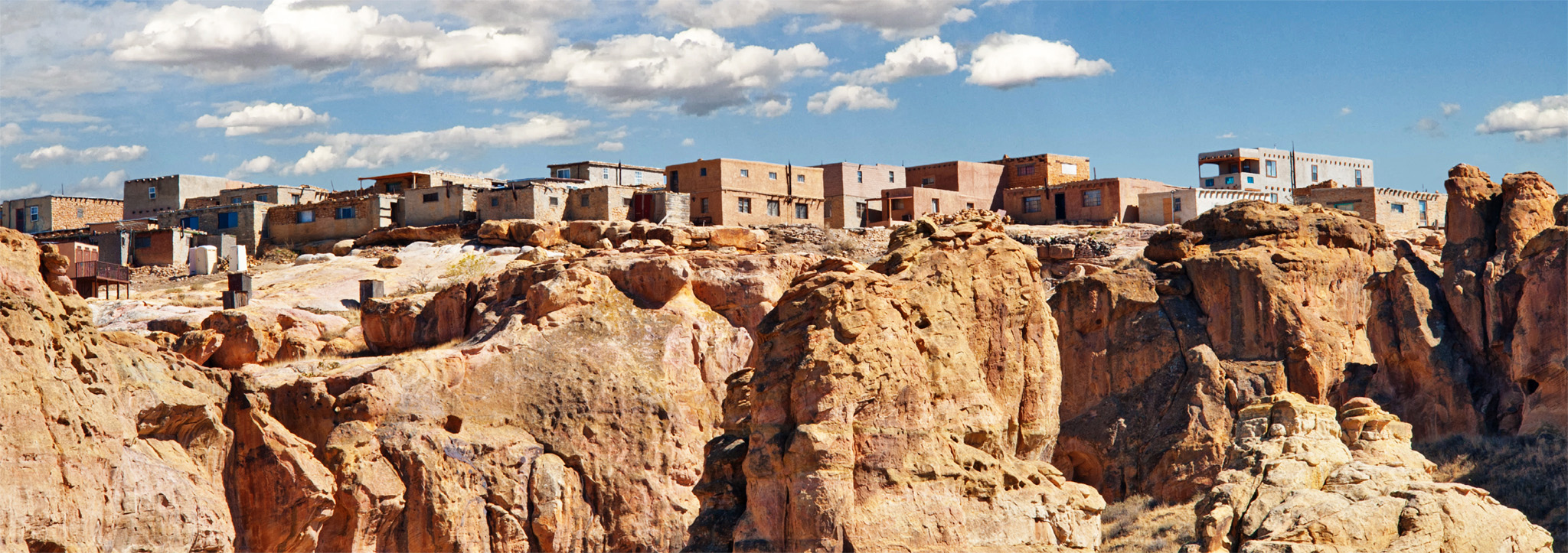
t Majestic sandhill cranes at Bosque del Apache National Wildlife Refuge
Socorro, meaning “aid” or “help” in Spanish, was named by conquistador and explorer Juan de Oñate. As his traveling party emerged from the desert in 1598, they were given food and water by the people of Pilabo Pueblo, which once stood here. The area was resettled in the early 1800s, and it was during the silver boom of the 1880s that many of its Victorian buildings were built. Just north of here is the 1821 San Miguel Mission, featuring massive adobe walls, supported by curved arches.
The Bosque del Apache National Wildlife Refuge, a renowned bird-watching area, lies 18 miles (29 km) south of Socorro. The 90-sq-mile (233-sq-km) refuge attracts many thousands of migrating waterfowl in winter, including snow geese, cormorants, and sandhill cranes.
"
Bosque del Apache National Wildlife Refuge
⌂ Hwy 1 # 8am–4pm daily (Jun–Aug: Thu–Mon only) ¢ Jan 1, Thanksgiving, Dec 25 ∑ fws.gov/refuge/Bosque_del_Apache
t Sandhill cranes at Bosque del Apache National Wildlife Refuge near Socorro
Known by locals as “T-or-C,” this town changed its name from Hot Springs to Truth or Consequences for the tenth anniversary of the game show of the same name, held here in 1950. The original hot springs still exist in the form of the bathhouses dotted around the town. For centuries the thermal springs drew Native Americans to the area, notably the prominent Apache leader Geronimo. Geronimo Springs Museum has displays on Apache history, including a life-size statue of the Apache warrior and information on other Native American famous figures. Warm mineral water from an underground spring flows down the ceramic mountains of an elaborate fountain in the plaza next to the museum. Nowadays, the town is a mecca for artists and free spirits.
Truth or Consequences is a popular summer resort, close to both the Elephant Butte Lake State Park (New Mexico’s largest body of water) and the Caballo Lake state parks. These are famous for their numerous water sports, such as fishing, jet skiing, boating, and windsurfing.
" =
Geronimo Springs Museum
⌂ 211 Main St § (575) 894-6600 # 9am–5pm Mon–Sat, noon–4pm Sun ¢ Public hols
"
Elephant Butte Lake State Park
⌂ Off I-25 ∑ emnrd.state.nm.us
SPACEPORT AMERICA
In the desert 30 miles (50 km) southeast of Truth or Consquences is the world’s very first purpose-built commercial spaceport, designed for privately operated space flights. Space tourism is still a long way off, but the site is open every Saturday for guided tours, which include a white-knuckle ride in a G-force machine. Book online (spaceportamericatour.com).
Situated 60 miles (97 km) west of Las Cruces, Deming is home to the Deming Luna Mimbres Museum, which houses an excellent collection of Mimbres pottery, frontier artifacts, and a fine gem and mineral display. Rockhounding (amateur rock and mineral collecting) often takes place in Rockhound State Park, where quartz, jasper, agate, and many other minerals can be found. The town is also known for its Great American Duck Race, run every August.
"
Rockhound State Park
⌂ Hwy 141 § (575) 546- 6182 # 7am–sunset daily
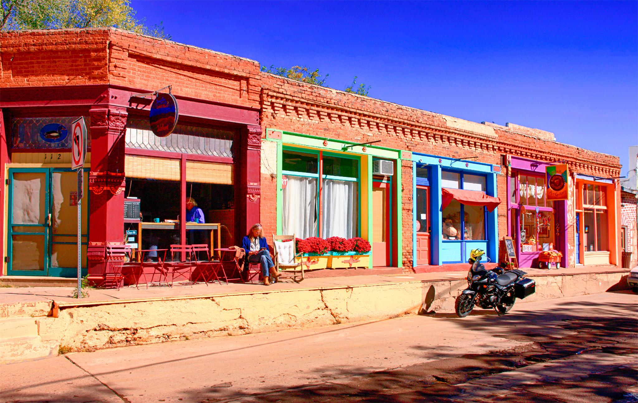
t Colorful galleries and cafés lining West Yankie Street in downtown Silver City
As its name suggests, Silver City was once a mining town. Located in the foothills of the Pinos Altos Mountains, Silver City’s ornate architecture dates from its boom period between 1870 and the 1890s. In 1895, a flood washed away the city’s main street, and in its place today is Big Ditch Park, an arroyo (or waterway) running some 50 ft (15 m) deep through the town. This area was the site of the cabin where Billy the Kid spent much of his youth.
Silver City has three defined historic districts – Chihuahua Hill, Gospel Hill, and the old downtown district – all of which contain buildings that evoke its Wild West boomtown past. Downtown is also home to a vibrant arts scene. Painters, potters, weavers, and other artisans have made it their home, and the area is overflowing with art galleries.
The Silver City Museum is located in the beautiful 1881 H. B. Ailman House, and houses a huge collection (some 20,000 objects) of frontier-era memorabilia. The Western New Mexico University Museum holds the world’s largest and most complete collection of Mimbres artifacts.
Silver City is a good base for exploring the area. The nearby forest is home to wildlife such as elk, deer, and bear, and there are several hiking trails and picnic areas.
Silver City Museum
⌂ 312 W Broadway # 9am–4:30pm Tue–Fri, 10am–4pm Sat & Sun ¢ Public hols ∑ silvercitymuseum.org
Western New Mexico University Museum
⌂ 1000 W College Ave # 9am–4:30pm Mon–Fri ¢ Public hols ∑ wnmu.edu/univ/museum.shtml
The Gila (pronounced “hee-la”) Cliff Dwellings are one of the most remote archaeological sites in the Southwest, situated among the piñon, juniper, and pon-derosa evergreens of the Gila National Forest. The dwellings occupy five natural caves in the side of a sandstone bluff high above the Gila River.
Hunter-gatherers and farmers called the Tularosa Mogollon established their 40-room village here in the late 13th century. The Mimbres Mogollon people, famous for their abstract black-and-white pottery designs, also lived in the area. The ruins are accessed by a 1-mile (1.5-km) round-trip hike from the footbridge crossing the Gila River’s West Fork. Allow about two hours to drive to the site from Silver City along the road winding through mountains and canyons.
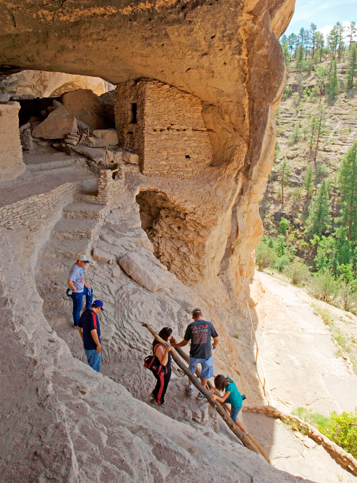
t Exploring the ruins of the sandstone Gila Cliff Dwellings
Spreading out at the foot of the Organ Mountains, Las Cruces, or “The Crosses”, was named for the graves of early settlers ambushed here by the Apache in 1787 and again in 1830. It has always been a crossroads – of frontier trails, of the railroads, and now two Interstate highways (10 and 25). Today, it is New Mexico’s second-largest city and home to New Mexico State University.
While the town is best used as a base for exploring the region, there are also a number of interesting museums to be found here. They include the Branigan Cultural Complex, which houses a cultural center with a historical museum, and the Las Cruces Museum of Art. Tours can also be arranged here of the nearby Bicentennial Log Cabin, a late 19th-century pioneer house of hand-hewn timber furnished with period antiques and artifacts.
Branigan Cultural Complex
⌂ 501 N Main St # 10am–4:30pm Tue–Fri, 9am–4:30pm Sat ¢ Public hols ∑ lascrucescvb.org
This adobe fort was built in 1865 to protect settlers and railroad construction crews in the Mesilla Valley from attacks by Apaches and outlaws. Its buildings once housed the 125th Infantry, a unit of African Americans known as Buffalo Soldiers. Douglas MacArthur, who was to command Allied troops in the Pacific in World War II, lived here for two years as a boy in the 1880s, when his father was post commander. The fort was abandoned in 1891. Living history demonstrations are sometimes held on weekends, with rangers in period uniforms portraying 19th-century army life. There are also exhibits on frontier life in the visitor center.
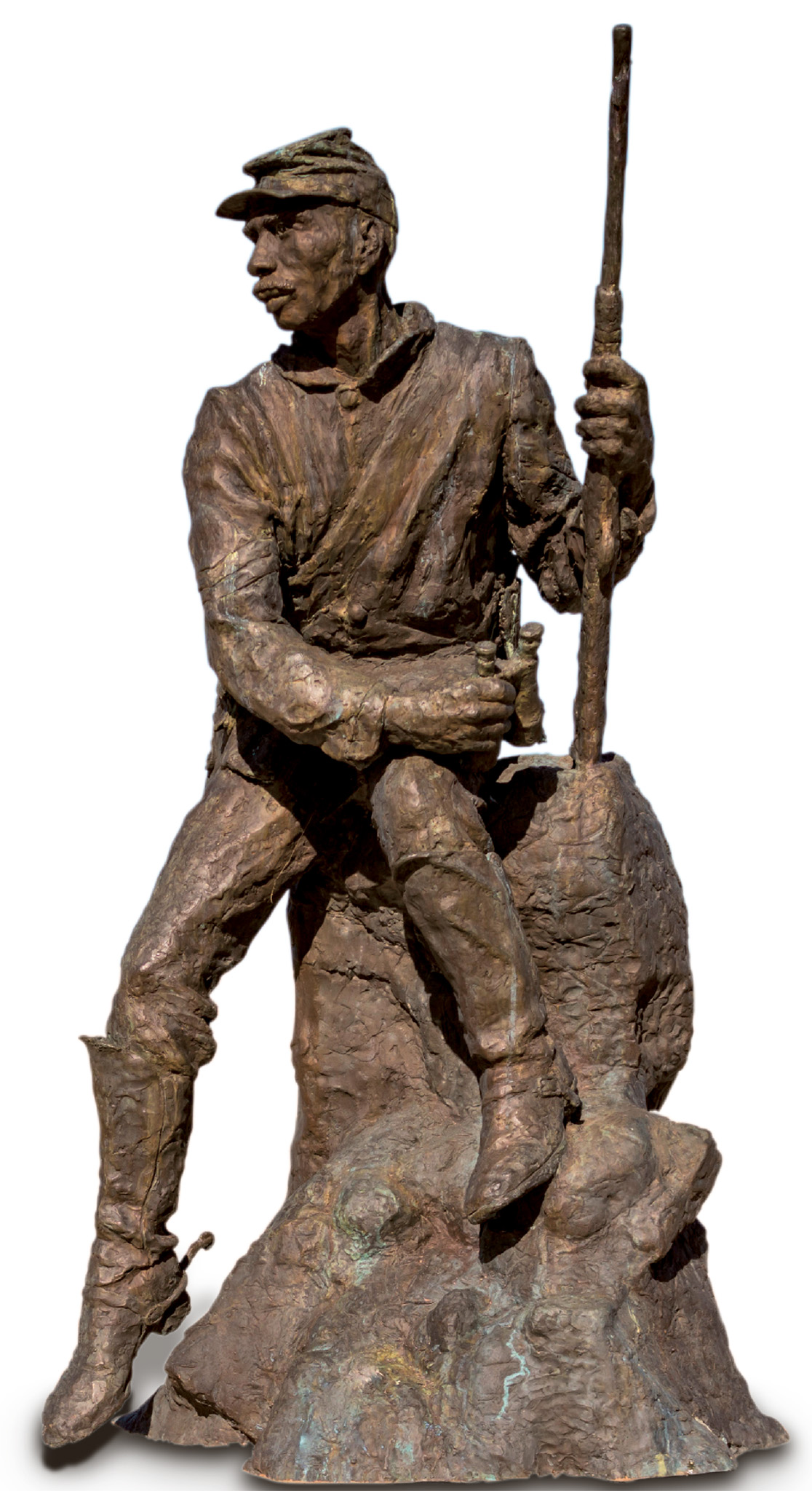
t A statue honoring the Buffalo Soldiers black infantry at Fort Selden
It was in the courthouse of this 19th-century frontier town that Billy the Kid was sentenced to hang in 1881. The Gadsden Museum contains exhibits on local history and cultures.
"
Gadsden Museum
⌂ 1875 Boutz Rd # By appt Wed–Sat ∑ gadsdenmuseummesilla.com
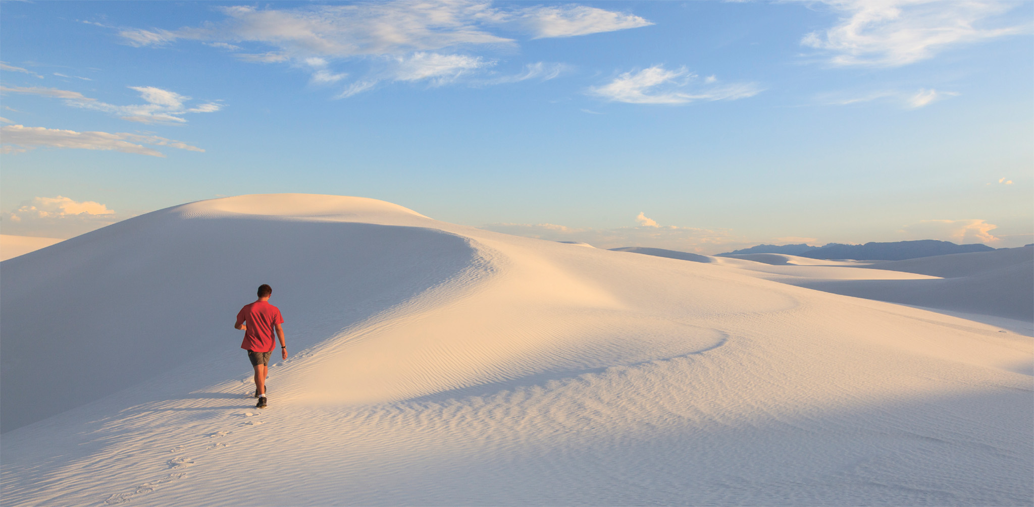
t Strolling across the glistening dunes at White Sands National Monument
The glistening dunes of the White Sands National Monument rise up from the Tularosa Basin at the northern end of the Chihuahuan Desert. It is the world’s largest gypsum dune field, covering around 300 sq miles (800 sq km). Gypsum is a water-soluble mineral, rarely found as sand. But here, with no drainage outlet to the sea, the sediment washed by the rain into the basin becomes trapped. As the rain evaporates, dry lakes form, and strong winds blow the gypsum up into the vast fields of rippling dunes.
Visitors can explore White Sands by car on the Dunes Drive, a 16-mile (25-km) loop. There are also five signposted hiking trails that will lead you around the park, including the wheelchair-accessible Interdune Boardwalk. Year-round ranger-led walks intro-duce visitors to the dunes’ flora and fauna. Only plants that grow fast enough not to be buried survive, such as the soaptree yucca. Most animals here are nocturnal, and include coyotes and porcupines.
The park is surrounded by the White Sands Missile Range. For safety, the park and road leading to it (Highway 70) may shut for up to two hours during testing. White Sands Missile Range Museum displays many of the missiles tested here.
White Sands Missile Range Museum
⌂ Hwy 70, 25 miles (40 km) E of Las Cruces # 8am–4pm Mon–Fri, 10am–3pm Sat ¢ Sun, public hols ∑ wsmr-history.org
Billy the Kid
Billy the Kid was one of the Old West’s most notorious outlaws. Born in 1859, he killed his first victim in 1877 and fled to Lincoln. In 1878, Billy helped form a vigilante group called the Regulators. After the Lincoln County War, Billy was captured by Sheriff Pat Garrett, escaped, and was eventually shot by Garrett on July 14, 1881. In spite of his violent life, Billy was a local hero whose story and deeds are now legendary.

t A rocket on display outside the glass cube of the New Mexico Museum of Space History in Alamogordo
Alamogordo was established as a railroad town in 1898. Its streets are lined with cottonwood trees, which reflect its origins – alamo gordo means “fat cottonwood” in Spanish. Located at the foot of the Sacramento Mountains, the town was a sleepy backwater until World War II, when it became a major defense research center.
The town is only 13 miles (21 km) from White Sands and offers many opportunities for outdoor activities, especially in the Lincoln National Forest on the eastern border. In town the New Mexico Museum of Space History, housed in a golden-glass, cube-shaped building, focuses on the history of the space race, with exhibits detailing living conditions inside a space station, a full-size replica of Sputnik I, the first space satellite, and a simulated space walk.
"
New Mexico Museum of Space History
⌂ Scenic Dr # 10am–5pm Mon, Wed–Sat; noon–5pm Sun ¢ Thanksgiving, Dec 25 ∑ nmspacemuseum.org
The picturesque mountain town of Cloudcroft was established in 1898 as a center for the lumber trade. Perched up in the Sacramento Mountains, the village became a favorite spot for escaping the summer heat of the valley below. Burro Avenue, running parallel to the main highway, looks much as it did at the turn of the 20th century, with its rustic timber buildings. Surrounded by the Lincoln National Forest, the town offers many outdoor sports. Just outside town is a trail to the restored Mexican Canyon Trestle, part of the 19th-century railroad that ran from Alamogordo to Cloudcroft.
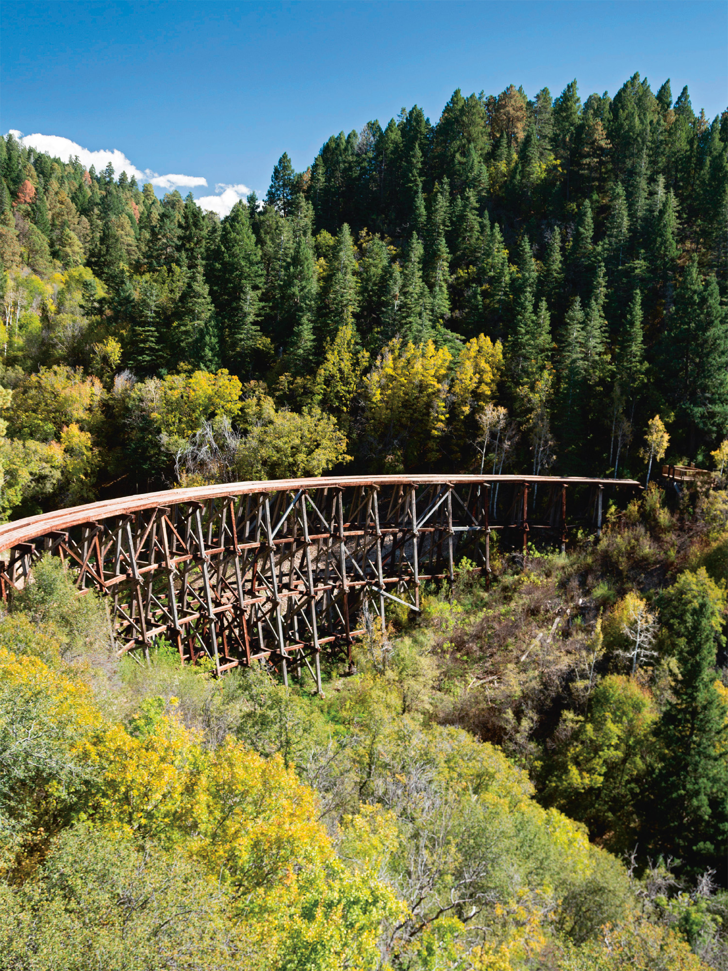
t Mexican Canyon Trestle near Cloudcroft in the Sacramento Mountains
The Roswell Incident
On July 4, 1947, an unidentified airborne object crash-landed in the Capitan Mountains, 75 miles (120 km) northwest of town. Jim Ragsdale was camping nearby and claims to have seen a craft hurtling through the trees and the bodies of four “little people,” with skin like snakeskin. The US Air Force issued a statement that a flying disc had been recovered. By July 9, however, they said it was just a weather balloon. Witnesses were allegedly sworn to secrecy, fueling alien conspiracy theories to this day.
Once just a small ranching town, Roswell has become a byword for aliens and UFOs, due to the now legendary Roswell Incident. The International UFO Museum and Research Center is devoted to the investigation of visitors from outer space and features an extensive collection of newspaper clippings, photographs, and maps of the crash site. A 70-minute film contains over 400 interviews with people connected to the crash.
The Roswell Museum and Art Center houses a collection of 2,000 artifacts on the history of the American West. The fascinating Robert H. Goddard Collection details 11 years of his experiments.
" =
International UFO Museum and Research Center
⌂ 114 N Main St # 9am–5pm daily ∑ roswellufomuseum.com
=
Roswell Museum and Art Center
⌂ 1011 N Richardson Ave # 9am–5pm Tue–Sun, 1–5pm Sun ∑ roswellmuseum.org
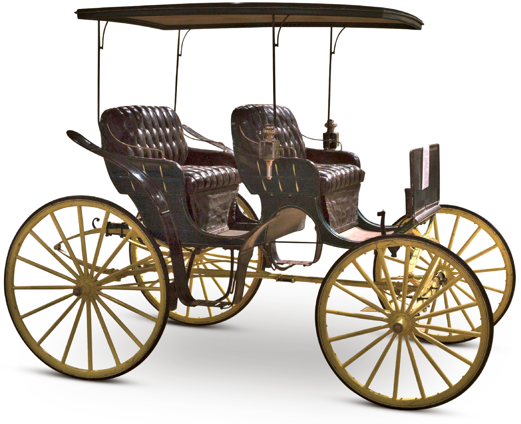
t A vintage carriage at the Hubbard Museum in Ruidoso
Nestled high in the Sacramento Mountains, surrounded by cool pine forest, Ruidoso is one of New Mexico’s fastest-growing resorts. Sudderth Drive is lined with shops, art galleries, cafés, and restaurants. Here, specialty shops sell everything from candles to cowboy boots.
Outdoor activities are the area’s major attraction, with hiking, horseback riding, and fishing. There are several golf courses, including the Links at Sierra Blanca, a top-rated 18-hole course. Northwest of the town is Ski Apache. Owned and operated by the Mescalero Apache Tribe, it is famous for its warm-weather powder snow. The town is best known for the horse racing at Ruidoso Downs Racetrack, which also has exhibits of racing artifacts. The Hubbard Museum of the American West has a collection of more than 10,000 pieces, ranging from fine art to horse-drawn carriages. Outside is the fabulous Free Spirits at Noisy Water (1995), a monument with seven larger-than-life horses. Every October, the town celebrates life in the Old West with the Lincoln County Cowboy Symposium, which features music and dancing, celebrity roping, and a cook-off.
A few miles north at Alto is the state-of-the-art Spencer Theater for the Performing Arts, a venue in a sandstone building with a spectacular mountain backdrop.
Links at Sierra Blanca
⌂ 105 Sierra Blanca Dr § (575) 258-5330
Ski Apache
⌂ 1286 Ski Run Rd ∑ skiapache.com
"
Ruidoso Downs Racetrack
⌂ Hwy 70 § (575) 378- 4431 # May–early Sep
"
Hubbard Museum of the American West
⌂ 26301 Hwy 70 W ∑ hubbardmuseum.org
"
Spencer Theater for the Performing Arts
⌂ 108 Spencer Dr ∑ spencertheater.com
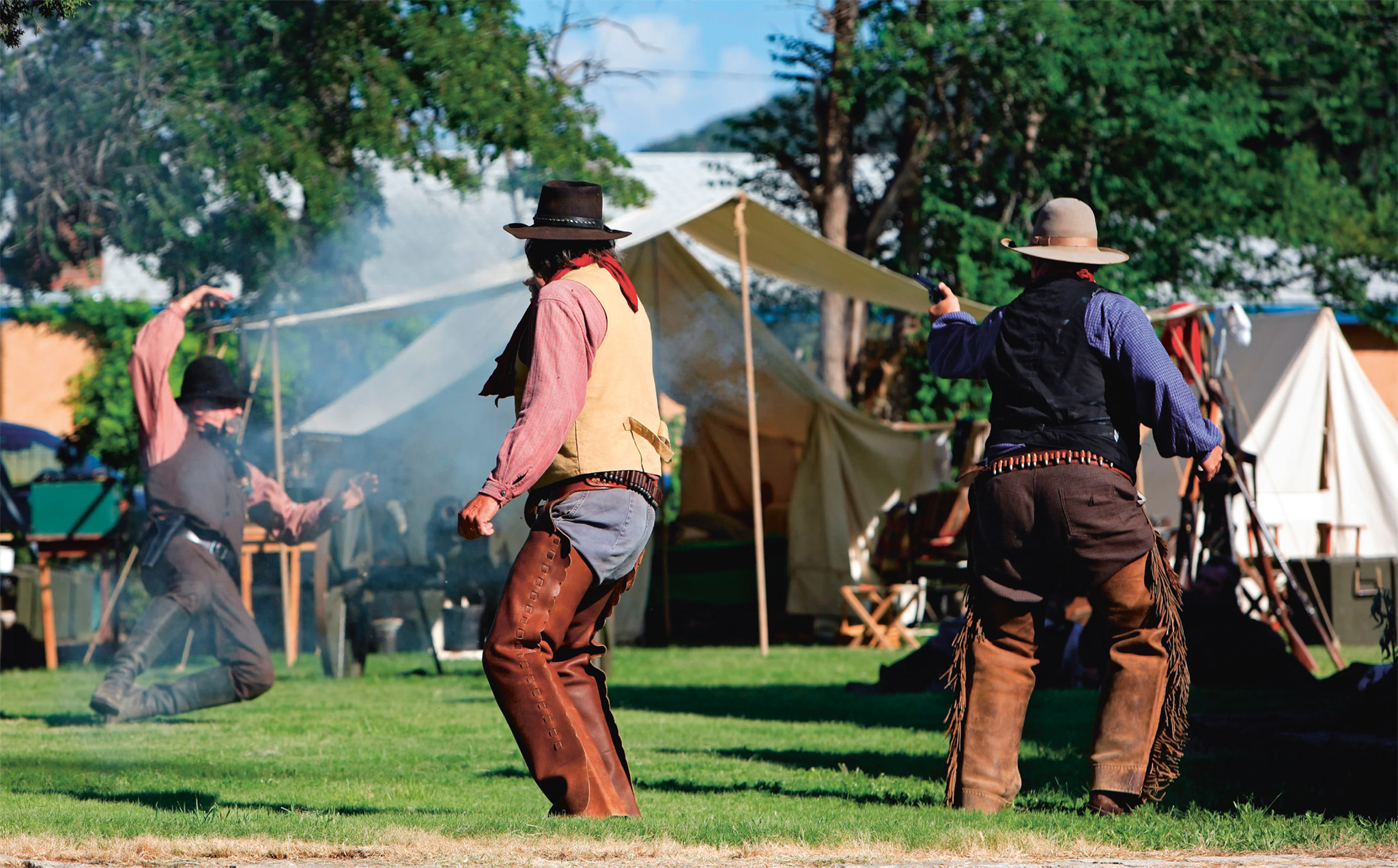
t A re-enactment of Billy the Kid’s escape from Lincoln County Jail
The peacefulness of this small town, surrounded by the beautiful Capitan Mountains, belies its violent past. It was at the center of the 1878 Lincoln County War, a battle between rival ranchers involving the legendary Billy the Kid. It is now a State Historic Site, with 11 buildings kept as they were in the late 1800s. At the Lincoln County Courthouse you can see where Billy the Kid was held, and the bullet hole made in the wall during his escape. The Tunstall Store is stocked with original 19th-century merchandise. The Historic Lincoln Visitor Center and Museum has displays on the Apache people, the early Hispanic settlers, and the Buffalo Soldiers all-black regiment from Fort Stanton, as well as the Lincoln County War.
The town of Carlsbad lies 20 miles (32 km) northeast of Carlsbad Caverns National Park. It has a relaxed, small-town atmosphere, with plenty of hotels and outdoor activities. The Pecos River winds through town; there are three lakes, and fishing, boating, and waterskiing are popular pastimes. At the northern edge of town, the Living Desert Zoo and Gardens State Park offers numerous exhibits focusing on the varied plants and animals of the Chihuahuan Desert.