Volcanic Rock Sequence Division and Stratigraphic Correlation
Volcanic rocks and strata have complex structures. In this chapter, the definition and division of volcanic rock sequences are discussed first, and their identification markers are established for stratigraphic sequence classification, which is carried out using a level-by-level control approach. Furthermore, the relationships between stratigraphic sequences and internal architectures (or gas reservoirs) are distilled to determine correlation relationships at each level of sequences. The delineation and correlation of volcanic rock sequences are guided by the principle of level-by-level control and constrained by internal architectures. This leads to a better understanding of the spatial distribution of volcanic rock sequences and helps establish a foundation for an appropriate division of development layer series.
3.1 Concept and levels of volcanic rock sequence
3.1.1 Concept of volcanic rock sequence
The basic concept of sequence was initially proposed in the late 18th century, with the strata of a sequence being bounded by top and bottom unconformities. In 1949, Sloss and colleagues formally used the term tectonic sequence for the first time and regarded sequence as a stratigraphic succession bounded by major regional unconformities. In 1988, van Wagoner and coworkers defined sequence stratigraphy as “the study of rock relationships within a chronostratigraphic framework of repetitive, genetically related strata bounded by surfaces of erosion or nondeposition, or their correlative conformities [1,2].” The early concept of sequence stratigraphy was derived from studies on marine deposits at passive continental margins, and hence it cannot be used to guide volcanic rock sequence classification. Shanley and colleagues pointed out that nonmarine sequence stratigraphic analysis can follow the general concept and methods of marine sequence analysis, but direct application is not advisable [3].
Up to now, there has been a lack of clear definition for volcanic rock sequence. Different scholars appear to have different concepts about volcanic rock sequence division. Taking into consideration the regularity of volcanic activity and especially volcanic rock formation, the former Regional Geology and Mineral Department of China classified volcanic rock sequences into four levels (or orders)—rock series, cycle, rhythm, and pulses—a scheme used during the conventional geological mapping projects [4]. On the basis of their spatiotemporal superposition relationships, the former Chinese Geological Survey Bureau divided the deposits from volcanic eruptions into four levels of cycles, following the methods and scheme of sedimentary sequence stratigraphy: cycle I (or first-order cycle) refers to an entire spatiotemporal process of basin evolution; cycle II (second-order cycle) stands for a specific stage magmatic evolution; cycle III (third-order cycle) represents a dormant episode of volcanic activity; cycle IV (fourth-order cycle) reflects eruption pulses of volcanic activity, equivalent to eruptive rhythm [5]. Xie divided nonmarine volcanic rock sequences into four levels (or orders) as cycle, formation, lithofacies, and stratum, and considered that a cycle corresponds to a volcanic edifice, a formation to an evolutionary stage of volcanic edifice, lithofacies to a specific volcanic eruption type, and a stratum being the smallest stratigraphic unit of volcanic deposits [6]. Huang and associates adopted a three-level scheme—cycle, period, and lithofacies—and used these terms in their study on the volcanic rocks of the Yingcheng Formation in the Songliao basin. In this scheme, a cycle corresponds to a volcanic edifice, a period to a lithofacies assemblage, and a lithofacies to a specific mode of volcanic rock formation, comprising one or more volcanic rock strata [7].
In light of the research results discussed previously [8–14], especially those pertinent to the volcanic rock sequences in the Songliao and Junggar basins, a volcanic rock sequence is defined in this study as various levels (or orders) of stratigraphic units with internal petrogenetic links and corresponding spatiotemporal relationships, bounded by regional unconformity surfaces on the top and at the bottom.
3.1.2 Levels of volcanic rock sequences
According to this definition, volcanic rock strata can be divided into four levels (analogous to orders of conventional sedimentary sequences), including, from large to small scale, volcanic eruption cycle, volcanic eruption period, volcanic eruption rhythm, and volcanic cooling unit.
1 Volcanic eruption cycle
A volcanic eruption cycle refers to all cogenetic volcanic eruption products with given architectural patterns formed at different stages of a single volcanic activity in the volcanic formation.
A volcanic eruption cycle is often related to a tectonic cycle. One or multiple volcanic edifices can be developed within one volcanic eruption cycle. Tectonic and eruption hiatuses usually occur between two successive cycles, expressed as a period of dormancy in volcanic eruption, resulting in the development of sedimentary interbed or weathered crust of various thicknesses. Thus, there usually exists an unconformity or erosional surface. A volcanic formation may comprise multiple eruption cycles, among which one eruption cycle can last tens of thousand years, with a lateral distribution range of tens to hundreds of kilometers and a volcanic rock succession reaching hundreds to thousands of meters. A volcanic eruption cycle usually begins with a near-crater facies association and forms a contact with the underlying strata through various unconformity surfaces; the cycle ends with a facies association relatively distal from the crater, which also forms a contact with the overlying strata through various unconformity surfaces, marked by sedimentary interbeds.
2 Volcanic eruption period
A volcanic eruption period refers to all volcanic products derived from one relatively continuous eruption during the formation of a volcanic edifice.
A volcanic eruption period is related to eruption energy change during the formation of a volcanic edifice. Two eruption periods are separated by an eruption dormancy marked by small discontinuity surfaces, such as a weathering crust, an unconsolidated layer, or sedimentary interbeds. One volcanic eruption period can last several thousand years, with lateral distribution up to several kilometers to tens of kilometers, and a volcanic rock succession reaching tens to hundreds of meters in thickness. The internal architecture representing a volcanic period typically shows continuous or quasicontinuous variation in the phase sequence, which corresponds to the intensity of volcanic activity. In the case of a weak-strong-weak eruption energy mode, for example, the corresponding phase sequence is typically effusive facies–explosive facies–effusive facies (extrusive facies/volcanic conduit facies); for a strong-weak eruption energy mode, the phase sequence is explosive facies–effusive facies (extrusive facies/volcanic conduit facies).
3 Volcanic eruption rhythm
A volcanic eruption rhythm refers to a volcanic rock association formed in a single eruption within an eruption period.
A volcanic eruption rhythm is related to the periodical variation in volcanic edifice eruption. The difference between two rhythms is represented by the variation in volcanic rock types, rock texture, and volcaniclastic grains. The duration of a volcanic eruption rhythm is relatively short, with a lateral distribution ranging from hundreds to thousands of meters, and a rock succession reaching several meters to tens of meters in thickness. According to the volcanic lava phase sequence association, the volcanic eruption rhythm can be divided into three types in terms of its internal architecture.
1) Volcanic lava rhythm
A single intensive effusion can produce a volcanic effusive facies comprising a lower, middle, upper, and top subfacies, whereas a multiple intensive effusive facies reflects the internal variation of effusive volcanic activity. On the basis of subfacies, therefore, a volcanic lava rhythm can be divided in terms of its phenocryst mineral composition, rock texture and structure variation of volcanic lava.
2) Volcaniclastic rock rhythm
A single intensive explosion can produce volcaniclastic rocks with different grain sizes and, therefore, a volcaniclastic rock rhythm always starts from volcanic conglomerate produced by the strongest energy and ends with dust- or ash-grade tuff produced by the weakest energy.
3) Interbedded rhythm of volcanic lava and clastic rock
A single intensive effusion can produce volcaniclastic rock and volcanic lava one after another, hence an interbedded rhythm of volcanic lava and clastic rock starts with volcaniclastic rocks reflecting strong energy and ends with volcanic lava from weak energy, thus forming a succession of volcaniclastic rock–volcanic clastic lava–volcanic lava in from bottom to top.
4 Cooling units
A cooling unit refers to the volcanic rock formed in the same eruption period but composed of multiple eruptive pulses, when the time interval between two pulses is sufficiently long to cool the volcanic rock surface of the earlier pulse to surface temperature to produce a cold-hot interface between two successive cooling units, with a cooling unit bounded in between. An unconsolidated layer can usually be found between two neighboring cooling units, with a soft top structure visible at the upper boundary and a hard bottom structure at the lower boundary. The lateral extent of a cooling unit can reach tens to hundreds of meters, with a thickness from several meters to tens of meters.
3.2 Challenges and technical solutions
3.2.1 Challenges
Volcanic rocks have special petrogenetic conditions. The accumulation mode and diagenetic processes are different from those of sedimentary rocks. This makes it difficult to apply the “stratified” stratigraphic correlation method for sedimentary rocks to volcanic rocks with complex stratigraphic structures and variations. For volcanic rock sequences, the difficulties or challenges in their identification, division, and correlation are different at various levels.
For high-level sequences (the volcanic formation and eruption cycle), the internal geological features, logging characteristics, and seismic responses are distinct, and the sequence boundary is marked by consistent sedimentary rocks, weathered crust, and volcanic ash, or by abrupt change in lithology. As a result, this type of sequence can be easily identified. For low-level sequences (eruption period, eruption rhythm, and cooling units), the internal geological features, logging characteristics, and seismic responses tend to be vague, and the sequence boundary is represented mainly by a thin volcanic sedimentary rock unit, small-scale weathered crust, transitional interface of lithological association, and cold-hot interfaces that change quickly with poor continuity, which make their identification difficult.
The high-level stratigraphic sequences are generally developed on a regional scale, with two successive sequences separated by a long volcanic dormancy and marked by clear time difference and spatial continuity; the sequence boundary is distinct and can be easily identified and correlated regionally. The low-level stratigraphic sequences are commonly confined to a local scale, with complex internal structures, separated by a short dormancy period; the sequence boundary is inconspicuous and difficult to identify and trace, tasks that are usually done through single-well identification and extrapolated using seismic responses. The internal sequences of different volcanic edifices are usually different, which poses a touch challenge to their regional stratigraphic correlation. The lower the sequence level, the greater the challenge for its division and correlation.
3.2.2 Technical solutions
In view of the difficulties and challenges in volcanic rock sequence division and correlation, the architectural constraints of volcanic rocks and sequence markers of different levels need to be used to identify, classify, and correlate volcanic rock sequences, following the principle of level-by-level control and correlation (Figure 3.1).

1 Establishing volcanic rock sequence identification markers
The geological characteristics of volcanic rock sequence, as well as the petrological properties, logging, and seismic response within the sequence and at the boundary, can be analyzed and distilled to generate geological markers, logging markers, and seismic facies patterns to identify a volcanic rock sequence at different levels and to establish a foundation for volcanic rock sequence identification.
2 Volcanic rock sequence identification
Based on the lithological and logging markers and the principle of level-by-level control, the core data and logging curves are applied together to identify the eruption cycle, eruption period, eruption rhythm, and cooling unit in wells at each level. Next, according to the seismic facies pattern, well-seismic combination and seismic response characteristics, and volcanic architectural constraints, the volcanic rock sequence is identified and the sequence boundary is traced on the seismic profile.
3 Volcanic rock sequence division and stratigraphic correlation
The relationships among a volcanic rock sequence, its internal architecture, and the development layer series can be established based on the geological characteristics of a volcanic gas reservoir. Then the constraint mechanism, scale, and distribution range at each level of the sequences are correlated and analyzed. In terms of the scale of their correlation, volcanic rock sequences are classified into three types:
Type 1: A sequence that can be correlated regionally is generally an eruption cycle.
Type 2: A sequence that can be locally delineated under the constraint of a volcanic edifice may be recognized as an eruption period or eruption rhythm.
Type 3: A sequence that can be identified only in single wells is usually a cooling unit.
On this basis, the sequence identification results can be applied to every well, and seismic reflections can be used as the constraints for interwell extrapolation; hence, the volcanic rock sequence can be divided and correlated following the principle of level-by-level control and correlation.
3.3 Volcanic rock sequence identification
Identification markers can be used in conjunction with systematic integration of such single-well data as cores, mud logs, and wireline logs to identify sequences in single wells, with sequence boundaries defined using seismic profiles, thus establishing a basis for sequence division and correlation.
3.3.1 Identification markers
Data from cores, wireline logging, mud logging, and seismic survey are employed together to establish the petrological, geophysical, and seismic identification markers for various levels of volcanic rock sequences (Table 3.1).
Table 3.1
Identification Marks for Volcanic Rock Sequence
| Identification object | Petrological characteristics | Control factors | Logging Response Characteristics | Seismic Reflection Characteristics | |||||||||
| Range | Typical Shape | Smoothness | Waveform | Amplitude | Frequency | Phase | |||||||
| Resistivity | Density | Acoustic Wave | |||||||||||
| Eruption cycle | Internal feature | Volcanic rock with similar composition | Volcanic formation | High | High | Low | Box shape | Micro-serrated ~ smooth | Chaotic | Strong | Low | Discontinuous | |
| Volcanic sedimentary rocks | Medium-low | Medium-low | Medium-high | Finger shape, Funnel shape | Serrated | Laminar | Medium-weak | Relatively high | Good continuity | ||||
| Cycle interface | Sedimentary rocks | Low | Low | High | Diverse shape | Serrated | Stratified | Weak | High | Continuous | |||
| Weathered crust (large scale) | Low | Low | High | Box shape, Funnel shape | Micro-serrated | Chaotic | Medium-strong | Low | Discontinuous | ||||
| Stable volcanic ash layer | Low | Medium-low | Medium-high | Box shape, Finger shape | Micro-serrated ~ serrated | Laminar | Strong | Medium | Discontinuous | ||||
| Abrupt boundary of volcanic rock composition | Abrupt gamma ray (GR), density (DEN), and neutron change | Weak reflection of local unconformity | |||||||||||
| Eruption period | Internal feature | Volcanic rock with identical composition | Volcanic edifice | High | High | Low | Box shape and bell shape | Serrated-micro-serrated | Chaotic | Strong | Low | Discontinuous | |
| Period interface | Volcanic sedimentary rocks | Medium-low | Medium-low | Medium-high | Finger shape and funnel shape | Serrated | Laminar | Medium-weak | Relatively high | Good continuity | |||
| Weathering crust | Medium-low | Medium-low | Medium-high | Finger shape | Serrated | Medium-strong reflection of local unconformity | |||||||
| Alternation surface of lithological assemblage | Indistinct | Indistinct | |||||||||||
| Eruption rhythm | Volcanic lava rhythm | Internal feature | Rhythmic lava assemblage | Volcanic massif | High | High | Low | Bell shape-funnel shape | Micro-serrated-smooth | Laminar | Medium-strong | Low | Poor continuity |
| Rhythm boundary | Rock structure variation plane | Small change | Indistinct | ||||||||||
| Volcaniclastic rock rhythm | Internal feature | Rhythmic volcaniclastic lithological assemblage | High | High | Low | Box shape, Bell shape, Funnel shape | Serrated-micro-serrated | Chaotic | Medium-weak | Low | Discontinuous | ||
| Rhythm boundary | Grain size variation plane | Small change | Curve shape change | Indistinct | |||||||||
| Interbedded rhythm | Internal feature | Interbedded lava and volcaniclastic rock | High | High | Low | Clock shape, funnel shape, finger shape | Serrated-micro-serrated | Stratified | Strong | Medium-High | Discontinuous | ||
| Rhythm boundary | Lava-volcaniclastic rock interface | Small change | Curve shape change | Indistinct | |||||||||
| Cooling unit | Internal feature | Volcanic rock | Volcanic rock facies | High | High | Low | Finger shape | Micro-serrated- serrated | Difficult to differentiate | ||||
| Unit boundary | Vesicular structure | Medium-low | Medium-low | Medium-high | Bell shape, Funnel shape | Micro-serrated | |||||||
| Amygdaloid structure | High | High | Low | Finger shape, Box shape | Micro-serrated | ||||||||
| Oxidization top, vitreous crust and baked edge | Indistinct | ||||||||||||

1 Identification markers of volcanic eruption cycle
The internal lithological differences within a cycle and cycle interfaces are the bases for identifying a volcanic eruption cycle.
1) Geological markers
A volcanic eruption cycle is the product of the same volcanic activity with a similar rock composition and continuous spatiotemporal distribution. Different cycles are separated by regional volcanic dormancy and a depositional hiatus.
Lithology within the cycle
The volcanic activity within a single eruption cycle is basically continuous but can be separated into many stages. Within one eruption cycle, for example, the eruption period is represented by volcanic rocks, and the dormancy period is represented by volcanic sedimentary rocks.
1. Volcanic rocks in the eruption period. The volcanic rock composition is mostly consistent, but there are multiple rhythmic lithology assemblages, which mainly reflect the variation patterns of eruption energy.
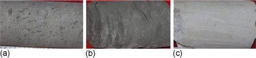
2. Volcanic sedimentary rocks in the dormancy period. There are two major volcanic sedimentary rock types between successive edifices and within one edifice, characterized by a high content of volcanic material, small thickness, and small areal distribution (Figure 3.2a).
Volcanic eruption cycle interface characteristics
There are four types of volcanic eruption boundaries, and different boundaries show different lithological characteristics and contacts.
1. Sedimentary rock interface. During a volcanic dormancy, various sediments accumulate, forming a regional sedimentary succession, characterized by high volcanic material content at the base and on the top, but low content in the middle (Figure 3.2b).
2. Weathering crust interface. The volcanic cap of an early eruption cycle is always weathered and eroded during the dormancy period, forming a weathering crust, which differs from normal volcanic rocks in its composition, color, and petrophysical properties. For example, the reactive components (e.g., FeO, K2O, and Na2O) tend to be leached, leading to a relative enrichment of inert components (e.g. TiO2 and MgO).
3. Volcanic ash interface. A volcanic eruption starts with a high amount of volcanic ash and ends with exotic volcanic ash during dormancy. Therefore, the cogenetic volcanic ash base and exotic volcanic ash top act as the basal and top markers of one eruption cycle, respectively.
4. Interface of abrupt change in volcanic rock composition. The magmatic components in different volcanic activity periods may be different; thus, the interface of an abrupt change (such as change from acid to basic) can act as the marker of an interface between two cycles.
2) Logging response characteristics
The logging characteristics within a cycle are as follows:
1. Volcanic rock in the eruption period. The logging characteristics of volcanic rocks include high resistivity, high density and low interval transit time; the logging curves are typified by smooth-dentoid and box shapes (Figure 3.3).

2. Volcanic sedimentary rock in dormancy period. The rock features are intermediate between volcanic and sedimentary rocks; the logging characteristics include medium-low resistivity, medium-low density, and medium-high interval transit time; the logging curves are mostly serrated, digitate, or funnel in shape, but borehole enlargement is reflected by sharp local peaks (Figure 3.3b).
The logging characteristics of a cycle interface are as follows:
1. Sedimentary rock interface. The logging characteristics of sedimentary rocks formed during the dormancy period include low resistivity, low density, and high interval transit time, reflecting the typically thick rock body, and enlarged borehole diameter. The logging curves are mostly dentoid-serrated box and bell in shape (see Figure 3.3b).
2. Weathering crust interface. After weathering, erosion, and leaching of reactive components, enrichment of inert components, and radioactive material absorption due to fluid movement, the weathered layer will show a decrease in K content, increase in Th and U contents and radioactivity, decline in resistivity and density, rise in interval transit time and neutron responses, and accentuated dentoid curve. The radioactivity curves are mostly bell shaped, and resistivity and petrophysical property curves are mostly funnel like (Figure 3.3a).
3. Volcanic ash layer boundary. Clay-grade volcanic tuff is characterized by very fine grain sizes and high interstitial and intramineral water content; the logging curve responses include low resistivity, low density, high neutron, and high interval transit time, characterized mostly by a smooth- microserrated box shape.
4. Interface of abrupt change in volcanic composition. The volcanic rock composition variation is reflected by its radioactivity, density, and neutron responses. With a change in acid-to-basic lithology, the radioactivity decreases, whereas the density and neutron increase.
3) Seismic reflection Characteristics
Seismic reflection characteristics within the cycle
1. Volcanic rock formation. The general characteristics include internal reflection of strong amplitude, low frequency, discontinuous event, and chaotic external reflection, with reduced amplitude for weathered crust. Different zones show different reflection characteristics: a volcanic edifice near the crater shows high seismic frequencies and poor event continuity, whereas a volcanic edifice away from the crater shows low reflection frequencies, good event continuity, and parallel or subparallel texture. The volcanic rock seismic reflection for different compositions is also different: an acid cycle shows a chaotic reflection waveform, low frequencies, and poor continuity, whereas a basic cycle shows high frequencies, good continuity, and a parallel, subparallel texture (Figure 3.4).
2. Sedimentary rock formation. Major characteristics include sublaminar reflections with weak amplitude, high frequencies, and a continuous event. The lower sedimentary rock unit, however, tends to show weak amplitude, high frequencies, and poor continuity due to the shielding effect of volcanic rocks (see Figure 3.4).
Seismic reflection characteristics of cycle interface
The interfaces between a weathered crust, sedimentary rocks, and volcanic rocks usually show a strong reflection of angular unconformity; the interface of volcanic composition change and the interface between fine tuff and other volcanic rocks mostly show unconformity but are characterized by poor reflection energy, continuity, and traceability (see Figure 3.4).
2 Identification markers of volcanic eruption period
1) Geological markers
A volcanic eruption period comprises volcanic rocks of a single, relatively continuous eruption within a volcanic edifice, and the lithological assemblages at different eruption periods and their sedimentary characteristics for the dormancy period are important identification markers.
Lithological characteristics within period
A volcanic eruption period differs from a volcanic eruption cycle in its relatively continuous volcanic activity. Within the period, volcanic rocks have a largely identical composition. In terms of magmatic property and eruption energy, there may be many types of lithological assemblages, such as a volcanic lava assemblage, an interbedded assemblage of volcaniclastic rock and volcanic lava, and a volcaniclastic rock assemblage. A period usually ends with quiet effusive lava or an early deposition of clay-grade tuff.
Period boundary characteristics
Volcanic dormancy refers to a break between successive periods of eruption within a volcanic edifice. Therefore, the rock bodies formed in different dormancy periods are different in lithology, shape, scale, and distribution.
Volcanic sedimentary rock interface
During an eruption dormancy between two periods, a volcanic edifice will receive clastic sediments derived from its own erosion or from surrounding rocks. These sedimentary rocks can be distinguished from those formed during an eruption dormancy between two cycles in having a higher content of volcanic material, with smaller thickness and limited distribution.
During a volcanic dormancy, volcanic rocks formed earlier will be exposed to weathering and erosion to form a concave or convex erosional surface. Intense chemical weathering usually results in a characteristic lateritic weathering crust. In contrast to the weathering layer in a cycle-level dormancy, the exposure time during a period-level dormancy is short, leading to the formation of a small-scale weathering crust within the volcanic edifice, with a limited areal distribution (Figure 3.5).

Transitional interface of lithological assemblage
When the eruption dormancy is short or the weathering is not intense, the volcanic sedimentary rocks and weathering crust will be underdeveloped, and two successive eruption periods will be separated by a transitional interface marked by a diagnostic lithological assemblage. Depending on the eruption energy variation, the transitional interface (from bottom to top) includes the volcanic tuff → volcanic breccia transitional interface, volcaniclastic rock → volcanic lava transitional interface, volcanic lava → volcanic clast transitional interface, and volcanic lava → volcanic lava transitional interface, and so on.
2) Logging response characteristics
1. Logging characteristics within period. The logging characteristics of volcanic rocks in an eruption period are typically high resistivity, high density, and low interval transit time; the logging curves are mostly microserrated ~ serrated box and bell shaped. The particular shapes are related to the lithological assemblages and their petrophysical properties.
2. Logging characteristics of period interface:
a. Volcanic sedimentary interface. Logging characteristics of volcanic rocks representing a dormancy include medium-low resistivity, medium-low density, and medium-high interval transit time; the curve is mostly serrated-digitate and funnel like, and partially bayonet like due to the generally small thickness.
b. Weathering crust interface. Logging characteristics of volcanic rocks in the dormancy include medium-low resistivity, medium-low density, and medium-high interval transit time. Due to its small thickness, the curve tends to be mostly serrated-digitate or bayonet like.
c. Transitional interface of lithological assemblage. Near the transitional interface of lithology assemblage, the logging response is related to the transition type. For example, for a transition of fine tuff → volcanic breccia, the logging curves show increased resistivity and density and decreased neutron and interval transit time, and the curves are serrated; for a transition of volcaniclastic rock → volcanic lava, the logging curve changes from a serrated bell shape to a microserrated box shape.
3) Seismic response characteristics
1. Seismic characteristics within period. Volcanic rocks generally have seismic reflection characteristics of strong amplitude, low frequency, and poor continuity; and the waveform is chaotic.
2. Seismic reflection characteristics of period interface:
a. Volcanic sedimentary rock interface. Seismic reflection characteristics of a thick succession of volcanic sedimentary rocks are typically of medium-weak amplitude, relatively high frequency, and relatively good continuity, and the waveform is nearly laminar; the seismic reflection characteristics of a thin volcanic rock unit are of medium-strong amplitude and good continuity along the unconformity.
b. Weathering crust interface. The seismic reflection characteristics show discontinuity and medium-strong reflection along the local unconformity.
c. Transitional interface of lithology assemblage. Due to its identical volcanic composition and similar physical properties, a transitional interface of lithology assemblage is indistinct in seismic profile and difficult to identify and trace.
3 Identification markers of volcanic eruption rhythm
Layer and rhythm are both unstable on a regional scale and can be generally correlated within a gas reservoir [1]. The identification markers of volcanic eruption rhythm include the following features.
1) Geological markers
1. Lava rhythm. For the rhythmic volcanic lava assemblage, the degree of crystallization is, from bottom to top, in the order of low-high-low, the degree of vesicle development in the order of relatively high-low-high, and the vesicle size in the order of medium-small-large.
2. Volcaniclastic rock rhythm. For the rhythmic volcaniclastic lithology assemblage, the clastic size changes, from bottom to top, from large to small, and the physical property changes from good to poor.
3. Interbedded rhythm of volcanic lava and volcaniclastic rock. This rhythm type is represented mainly by alternations of volcanic lava, volcanic clastic lava, and volcaniclastic rock, reflecting variations in eruption energy.
2) Logging response characteristics
Lava rhythm
In response to the geological characteristics of a lava rhythm, the logging curves usually comprise three segments. The lower segment is mostly characterized by medium-low resistivity, medium-low density, and medium-high interval transit time, with the curve having mostly a serrated funnel shape, but this segment is usually absent; the middle segment is characterized by high resistivity, high density, and low interval transit time, with the curve having mostly a microserrated boxlike shape; and the upper segment is characterized by low resistivity, low density, and high interval transit time, with the curve being mostly in the shape of a serrated bell (Figure 3.6).
Volcaniclastic rock rhythm
The logging curves generally have a serrated funnel and box shape, and the reservoir physical property shows a spiraling decrease from bottom to top. The logging characteristics of the lower volcanic breccia include low resistivity, low density, and high interval transit time, and the curve is mostly in the shape of a serrated box; the logging characteristics of the middle tuff breccia or breccia tuff include medium-high resistivity, medium-high density, and medium-low interval transit time, with finer-grained tuff showing lower resistivity and density values, but greater interval transit time. The logging curves are microserrated box and funnel in shape (Figure 3.7).

Interbedded rhythm of volcanic lava and volcaniclastic rock
The logging curves are in various shapes. The lower volcaniclastic rock unit has such logging characteristics as medium-low resistivity, medium-low density, and medium-high interval transit time, and the curves are mostly denticulate ~ serrated bell and funnel in shape; the middle clastic lava has logging characteristics of low resistivity, low density, and high interval transit time, with the curves being mainly microserrated to serrated box in shape; the upper volcanic lava unit has the logging characteristics of medium-high resistivity, medium-high density, and medium-high interval transit time, and the curves are mainly smooth to microserrated bell and box in shape; the top vesicular lava has logging characteristics of low resistivity, low density, and high interval transit time, with the curves being mainly microserrated-digitate and bell shaped (Figure 3.8).

3) Seismic markers
The volcanic lava rhythm mainly mirrors the sublaminar reflection characteristics of medium-strong amplitude, low frequency, and good continuity; the seismic reflection energy for volcaniclastic rock rhythm is relatively weak, having mostly chaotic reflection characteristics of medium-weak amplitude, low frequency, and poor continuity; the stratification of interbedded rhythm of volcanic lava and volcaniclastic rock is relatively good, mostly corresponding to the laminar reflection characteristics of strong amplitude, medium-high frequency, and good continuity.
4 Identification markers of cooling unit
1) Geological markers
When the time interval between two pulses of eruption is sufficiently long, there will be a cold-hot interface between two successive cooling units. A cooling unit is the basic component within volcanic rocks, marking a hiatus between two cooling units. The geological markers include the following:
1. Soft top and hard bottom structures. Due to different cooling conditions at the top, in the middle, and at the bottom of a cooling unit, soft top structures can be found in the upper interface and a hard bottom structure in the basal interface.
2. Vesicles and amygdaloids. When lava erupts, a sudden pressure drop results in degassing of abundant volatile components and usually the formation of numerous vesicles near the lava top in a globular and sometimes irregularly cloudy shape. Such volatile contents are relatively low at the base, and a small amount of gas can escape only when the lower rock is baked. Thus, compared to the top, the basal vesicles are less common and have a different shape, usually tubular, curved tubular, or elliptical. The cooling in the middle part is slow, with crystallization being the main diagenetic feature, and the vesicles are underdeveloped.
3. Oxidization top. After a volcanic eruption, the volcanic rock surface is in contact with air to facilitate strong oxidization, converting Fe2 + into Fe3 + and producing a brownish red oxidization top. However, the volcanic rock bottom is not exposed and remains in a reducing environment; hence, it is usually green. This color feature of “red top and green bottom” can serve as a marker of stratification.
4. Vitreous crust and molten slag crust. The surface lava flow produces a thin vitreous crust on its top due to fast cooling, and this thin crust is generally dark, greenish black for basic lava and mauve to brown for neutral-acid lava. The crust is usually several millimeters to several centimeters thick. The top of some neutral-acid lava contains a large amount of volatiles, which escapes quickly to produce a coarse vitreous crust on the top.
5. Baked edge. Hot magma in the eruption bakes the underlying rocks that cooled early to produce a thin baked edge marked by color fading.
2) Logging response characteristics
Because of its consistent composition, the rock texture and structure of a cooling unit will change only slightly at the top and bottom, which leads to small logging variations for the unit. The change in vesicles and amygdales causes regular changes in lava physical properties, resistivity, density, and interval transit time. In combination with rock texture and structure identification, the logging data can be used to identify a cooling unit.
3.3.2 Single-well identification
According to the geological markers and logging characteristics, the level-by-level control method can be used to identify the volcanic rock eruption cycle, period, rhythm, and cooling unit in single wells, as is demonstrated here using Well XX14 as an example.
1 Determining the environmental characteristics of volcanic eruption in single wells
Volcanic rocks of the Yingcheng Formation in the XX gas field constitute a suite of acid volcanic deposits, characterized by gray to off-white rhyolite, breccia lava, welded breccia, welded tuff, crystalline tuff, volcanic breccia interbedded with thin black mudstone, and silty mudstone, and the volcanic formation is divided into three eruption cycles according to regional eruption breaks. Well XX14 lies in the southwest of the volcanic formation and reveals the third, the second, and the top part of the first cycles.
2 Identifying lithology and rock composition, eruption dormancy, and eruption cycle
Regionally distributed sedimentary rocks and weathered layer, continuously distributed fine tuff, abrupt interface of volcanic rock composition, and extrusive facies are key indicators for recognizing eruption dormancy and differentiating volcanic cycles.
In Well XX14, there are mainly acid volcanic rocks with nearly identical composition. However, separated by a volcanic sedimentary rock unit in the 3949-3987 m interval, the Th content in the upper volcanic rocks is almost twice as high as in the lower part; and K content is relatively low, showing different alkalinity in the upper and lower volcanic rocks; meanwhile, this well encounters volcanic conduit facies and extrusive facies in the basal 30 m. According to the sedimentary rocks, rock compositions, and extrusive facies markers, therefore, three eruption cycles can be recognized, with the boundaries at 3948 m and 4125 m from top to bottom, respectively (see the fourth column on the right in Figure 3.9).
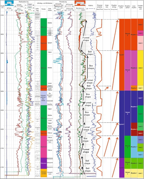
3 Finding marker of eruption dormancy within volcanic edifice and identifying eruption period
In a volcanic edifice, the direct criteria for determining eruption dormancy and identifying eruption period include the volcanic sedimentary rocks, weathering crust, and transitional interface of lithological assemblage. In Well XX14, the volcanic edifice is a centered type composed mainly of effusive facies with some explosive facies. Here, there are three eruption cycles with no volcanic sedimentary rocks or typical weathering crust inside; hence, the lithological assemblage conversion is employed to identify the eruption period.
In Well XX14, a volcaniclastic rock ~ rhyolite assemblage and a volcanic breccia ~ tuff assemblage occur from top to bottom. In cycle 1, the volcanic conduit facies and extrusive facies belong to different eruption periods, with logging curves being microserrated bell in shape. In cycle 2, there is a volcanic breccia ~ breccia tuff ~ tuff assemblage and volcanic breccia ~ breccia lava ~ rhyolite ~ volcanic sedimentary assemblage, with logging curves being mainly microserrated box and funnel in shape, and the boundary is at 4066.8 m. In cycle 3, there is a crystalline tuff ~ tuff lava ~ rhyolite assemblage, with logging curves having bell ~ funnel ~ box ~ bell shapes; there is another breccia lava ~ rhyolite assemblage, with logging curves being funnel shaped. Thus, the lithological assemblage and logging curve characteristics indicate the presence of six eruption periods in three volcanic rock cycles in Well XX14, with each cycle containing two eruption periods (see the third column on the right in Figure 3.9).
4 Identifying volcanic eruption rhythm based on petrophysical properties, grain size variation, and lithological assemblages
On the basis of contact relationships between volcanic lava and volcaniclastic rock, as well as characteristics of each rhythm, various volcanic eruption rhythms can be identified, and the volcanic eruption rhythm distribution in single wells can be revealed.
In the noncored intervals, three types of volcanic rock rhythm can be effectively identified according to the variation rule of volcanic lava petrophysical properties from medium-small-large, volcaniclastic rock grain size from large to small, and lithological assemblage of interbedded volcanic lava and volcaniclastic rock from bottom to top. In Well XX14, eight eruption rhythms are developed in six eruption periods (see the second column on the right in Figure 3.9). Two interbedded rhythms in cycle 1 are consistent with the period scale. Period 1 in cycle 2 comprises one volcaniclastic rock rhythm, with logging curves being serrated box-funnel in shape; and period 2 consists of two interbedded rhythms, with logging curves being two clusters of serrated box-funnel combination. Period 1 in cycle 3 contains one volcaniclastic rhythm, with logging curves being microserrated bell in shape with small thickness. It also contains one interbedded rhythm, with logging curves showing a combined funnel-box-bell shape; and period 2 develops one interbedded rhythm, with logging curves being smooth-microserrated funnel in shape.
5 Recognizing cooling boundary and identifying cooling unit of volcanic rock
Soft top and hard bottom structures, oxidization top, vitreous crust, molten slag crust, baked edge, vesicle, and amygdaloid are the typical markers for distinguishing cooling units. Because the logging characteristics of most markers are indistinct, the abrupt contact of rock type, regular variation of vesicle and physical properties, as well as logging curves can be used to identify cooling units.
In Well XX14, there are 12 abrupt lithological interfaces reflecting eruption energy change, among which two interfaces reflect the regular change in petrophysical property. A comprehensive analysis under the constraint of eruption rhythm framework, therefore, recognized 14 cooling units in this well (see the first column on the right in Figure 3.9), among which there are two units in cycle 1, with the same scale as that of a rhythm and period; seven units in cycle 2, including two volcanic breccia units, one breccia tuff unit, one fine tuff unit, two rhyolite units, and one volcanic sedimentary rock unit; and five units in cycle 3, including one crystal tuff unit, three rhyolite units, and one breccia lava unit.
3.3.3 Profile identification
1 Identification of volcanic eruption cycle
Volcanic eruption cycles can be identified according to their seismic response mode, in conjunction with regional geology and seismic reflection analysis.
1) Sedimentary rock as cycle separator
The alternating occurrence of sedimentary and volcanic rocks reflects the episodic nature of volcanic activity. For example, three volcanic eruption cycles were found in the volcanic rocks of the DD gas field, which reflect three coupled sets of volcanic and sedimentary rocks. The bulk of these cycles is represented by volcanic rocks in their lower part. The upper sedimentary rock unit constitutes the barriers in these cycles. On the seismic profile, the volcanic eruption cycle shows alternating strong-weak seismic reflection characteristics throughout the area, and the volcanic-sedimentary rock interface shows a strong reflection of regional discontinuity on seismic profiles (Figure 3.10).

2) Weathering crust as cycle separator
Uplift and erosion of the early cycle result in a prominent regional weathered layer, which is the interface of paraconformity or angular unconformity. In the XX gas field, for example, there are three eruption cycles with predominantly acid volcanic rocks, and the cycles are in contact with each other through paraconformity; the reflection characteristics inside the cycles are similar in seismic profiles, and the cycles are separated by a discontinuous and traceable unconformity (Figure 3.11).
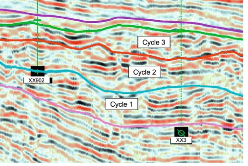
3) Magma evolution cycle
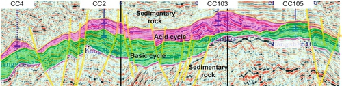
This type of cycle reflects the periodical evolution of magma compositions. For example, the volcanic rocks in CC gas field comprise two eruption cycles, with an discontinuous unconformity between the lower basic cycle and the upper acid cycle. In seismic profiles, there are different seismic responses inside each volcanic eruption cycle, characterized mainly by pseudolaminar reflections with medium-high frequency, medium-weak amplitude and good continuity in the lower part of each cycle, and chaotic reflections with strong amplitude, low frequency, and discontinuity in the upper part of each cycle (see Figure 3.4).
2 Identification of volcanic eruption period
For different volcanic edifices, the eruption periods are different, and their identification should be carried out within the framework of volcanic edifice. In different eruption periods, the lithological assemblage, rock texture, structure, and strike are different. There are diagnostic characteristics of volcanic sedimentary rocks for volcanic dormancy, local weathering crust, and transitional interface between successive eruption periods, forming locally unconformable contacts between volcanic periods. The seismic reflections, therefore, are typically chaotic; they are of weak amplitude, low frequency, and discontinuity inside each period, and the boundaries between successive periods are discontinuity surfaces with strong reflection characteristics. An eruption period inside a volcanic edifice can be identified based on the strong reflections in the bottom and top parts and weak reflections in the middle.
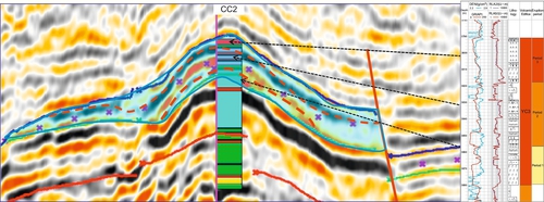
A volcanic edifice, composed mainly of basic volcanic rocks and formed by fissured–centered eruption, was found in the Yingcheng Formation in Well Block CC2 (Figure 3.12). This edifice contains three suites of volcanic rocks of 12-m to 30-m thickness and two suites of volcanic sedimentary rocks of 10-m to 13-m thickness, which suggests three eruptions separated by two eruption hiatuses. Hence, this edifice can be divided into three volcanic eruption periods. In the seismic profile, the internal part of this edifice shows laminar reflections with relatively strong amplitude, medium frequency, and good continuity. The integrated well-seismic calibration shows that the reflections of the basalt formation in stages 1 and 3 have a relatively weak amplitude and good continuity; and the reflections of basaltic clastic rocks in stage 2 have a relatively strong amplitude and poor continuity; and the period interface shows strong reflections of the local paraconformity under the constraint of the volcanic edifice (see Figure 3.12).
3 Identification of volcanic eruption rhythm
The largely homogeneous composition of a volcanic eruption rhythm leads to indistinct seismic reflection characteristics for the rhythm interface. With the constraint of the volcanic edifice and eruption period, therefore, the eruption rhythm can be identified by tracing the event, in combination with integrated well-seismic calibration, as is shown in the following case study on volcanic edifice YC21 in the CC gas field (Figure 3.13).
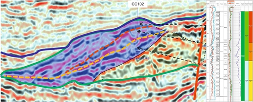
1) Identification from single well
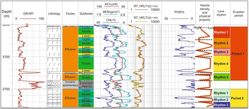
Volcanic edifice YC21 encountered in Well CC102 consists of a lower rhyolite unit about 150 m thick, a middle volcanic breccia unit about 70 m thick, and an upper rhyolite unit about 120 m thick. In terms of the volcanic sedimentary rock characteristics typical of volcanic dormancy, two periods are recognized (see the right part in Figure 3.13).
Constrained by eruption period, volcanic rock in the lower subfacies of the early effusive facies is not recognized but generally shows a complete vesicle sequence (underdeveloped → developed) and a petrophysical property sequence (poor → good), typical of a volcanic lava rhythm. Volcanic rocks of the late effusive facies also have a complete vesicle and petrophysical property sequence, although the late explosive facies does not have a complete grain size variation sequence but has a complete petrophysical property variation sequence. Thus, one volcanic lava rhythm and one volcaniclastic rock rhythm are recognized, and the volcanic edifice in this well contains two volcanic eruption periods and three eruption rhythms (see Figure 3.13).
2) Identification from seismic profile
Volcanic eruption periods can be identified within a volcanic edifice on the basis of well-seismic calibration, differences in internal reflection characteristics, and a strong reflection of local unconformity, With this constraint, the identification of an eruption rhythm can begin from a single-well seismic profile according to its pseudolaminar reflection of the volcanic lava rhythm, chaotic reflection of volcaniclastic rock rhythm, and paraconformity of the rhythm interface.
In Figure 3.13, the yellow line represents the boundary between two eruption periods inside the YC21 volcanic edifice, and the red line represents the boundary between two eruption rhythms within the second eruption period. The upper and lower volcanic lava rhythms show laminar reflections with strong amplitude, low frequency, and good continuity; the middle volcaniclastic rock rhythm shows chaotic reflections with medium-strong amplitude, low frequency, and discontinuity; the upper and lower interfaces show reflections of a local unconformity, but there are event crossings in interface tracing, making it difficult to identify the volcanic eruption rhythm interface based on the seismic profile.
The cooling unit is small and distributed in a limited area; due to its low resolution, the seismic data are rarely used for its identification and division.
3.4 Volcanic rock sequence division and stratigraphic correlation
Through volcanic rock sequence identification, correlation, and analysis, the volcanic rock sequence and internal architecture, as well as their relationships to gas reservoirs, can be established, and the stratigraphic sequences can be correlated at different levels. With the constraint of internal architecture, the volcanic rock sequences can be classified and the formation correlated level by level.
3.4.1 Corresponding relationships among volcanic rock sequence, internal architecture, and gas-bearing zone
The corresponding relationships among the volcanic gas-bearing zone, stratigraphic sequence, and internal architecture of volcanic rocks can be established based on an analysis of their internal architecture and stratigraphic sequences (Table 3.2).
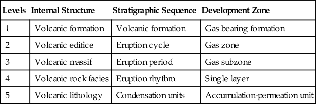
Table 3.2
Corresponding Relationship of Volcanic Gas-Being Zone to Stratigraphic Sequence and Internal Structure
| Levels | Internal Structure | Stratigraphic Sequence | Development Zone |
| 1 | Volcanic formation | Volcanic formation | Gas-bearing formation |
| 2 | Volcanic edifice | Eruption cycle | Gas zone |
| 3 | Volcanic massif | Eruption period | Gas subzone |
| 4 | Volcanic rock facies | Eruption rhythm | Single layer |
| 5 | Volcanic lithology | Condensation units | Accumulation-permeation unit |
1 Gas-bearing formation corresponding to the volcanic formation
A gas-bearing formation comprises continuous deposits within a level 2 depositional cycle, characterized by similar depositional origin and rock types, consistent gas and water features, and a cap layer of thick mudstone. The top and bottom boundaries of a gas-bearing formation are consistent with its time interface, and one gas-bearing formation comprises several gas zones.
A volcanic formation is a volcanic rock assemblage with a closely related petrogenesis, continuous spatiotemporal occurrence, similar rock type, and consistent gas and water characteristics; its top and bottom contacts with surrounding rocks are marked by regional angular unconformities, consistent with the stratigraphic age interface, and one volcanic formation comprises multiple volcanic eruption cycles or volcanic edifices.
Within the volcanic gas reservoir range, the volcanic formation corresponds to the gas-bearing formations.
2 Gas zone corresponding to the volcanic eruption cycle and edifice
In level 3 depositional cycles, the gas-bearing layers with similar depositional environments, distributions, rock properties, petrophysical properties, and natural gas properties are classified into one gas zone but separated by relatively thick and stable interbeds. The gas zone interface is consistent with the sedimentary cycle interface, and one gas zone comprises several gas subzones.
A volcanic eruption cycle is a volcanic rock assemblage erupted in the same period from the same magma source in one or multiple edifices. The petrogenic environment, distribution, rock property, petrophysical property, and fluid property are relatively similar. The top and bottom layers are stable sedimentary rocks or a weathered crust. One eruption cycle comprises several volcanic edifices and internal eruption periods.
Within a volcanic gas reservoir, the volcanic eruption cycle and edifice correspond to the gas zone.
3 Gas subzone corresponding to the volcanic eruption period and volcanic massif
The enriched gas layers within a gas zone are grouped into one gas subzone, consistent with the horizons in a level 4 depositional cycle. The gas subzones are separated by stable barriers, and one gas subzone includes many gas layers.
A volcanic eruption period is represented by a volcanic rock assemblage formed in the relatively concentrated explosions within a volcanic edifice, its bottom and top are separated by relatively stable sedimentary rocks or weathered crust, and there are several layers composed of volcanic eruption rhythms inside the period.
In a volcanic gas reservoir, the volcanic eruption period and volcanic massif correspond to gas subzone.
4 Single layer corresponding to volcanic eruption rhythm and volcanic facies
A continuous gas interval separated by impermeable beds can be grouped into one single-layer [15]. A single layer corresponds to a horizon in a level 5 depositional cycle. In practice, the classification criteria for single layers should be the same within one development district, but they can be different in different development districts in a gas field [16]. Generally speaking, the independent layers with half the area of the development district can be grouped into single layers, and one single layer can contain several accumulation-permeation units.
Volcanic eruption rhythms are the volcanic rock assemblages formed by one concentrated eruption of a volcanic period. They have the lithological characteristics of a facies sequence and contain several cooling units.
In a volcanic gas reservoir, volcanic eruption rhythms and volcanic rock facies correspond to single layers.
5 Accumulation-permeation unit corresponding to cooling unit and volcanic lithology
A cooling unit is developed within the lithofacies equivalent to the volcanic lithology; and the cooling unit and volcanic lithology correspond to the accumulation-permeation unit.
3.4.2 Correlation of volcanic rock sequence
On the basis of the corresponding relation described previously and according to the geological features, constraints, scale, and distribution range of the volcanic rock sequence, the correlation at each sequence level is systematically determined (Table 3.3).
Table 3.3
Volcanic Rock Sequences
| Stratigraphic Sequence | Constraint Mechanism | Distribution Range | Scale | Correlation | |
| Thickness | Extension | ||||
| Eruption cycle | Volcanic formation | Inside the basin | Hundreds to thousands of meters | Tens to hundreds of kilometers | Regional correlation |
| Eruption period | Volcanic edifice | Inside the edifice | Tens to hundreds of meters | Several to tens of kilometers | Division inside the edifice |
| Eruption rhythm | Eruption period | Several meters to tens of meters | Hundreds to thousands of meters | ||
| Cooling unit | Eruption rhythm | In the massif | Several meters to tens of meters | Tens to hundreds of meters | Extrapolation from single well |

1 Volcanic eruption cycle
A volcanic eruption cycle represents the product of volcanic activities at different stages within a volcanic formation, separated by long-term volcanic dormancy with distinct time difference and spatiotemporal continuity. It serves as a geological basis for dividing the gas-being zones of a volcanic gas reservoir. Such a cycle can be hundreds to thousands of meters thick and extend for tens to hundreds of kilometers, with a large areal range, or even covering an entire basin. Meanwhile, there are stable sedimentary rocks or a weathered crust between successive cycles. Therefore, volcanic eruption cycles can be correlated regionally within the range of a volcanic formation.
2 Volcanic eruption period
A volcanic eruption period consists of the product of one continuous eruption within a volcanic edifice, which is separated by short-term volcanic dormancy and characterized by spatiotemporal continuity (i.e., without recognizable time difference within the rock unit). It forms the geological basis for dividing the gas subzones of a volcanic gas reservoir. A period may be represented by rocks from tens to thousands of meters thick and extend laterally from several meters to tens of kilometers, with a moderate distribution range within the volcanic edifice. Therefore, the stratigraphic division and correlation of volcanic eruption periods can be carried out inside the range of a volcanic edifice.
3 Volcanic eruption rhythm
A volcanic eruption rhythm is the product of one concentrated eruption inside the eruption period and is separated by the regular interface of lithology assemblages. It serves as a geological basis for dividing the gas layers of a volcanic gas reservoir. A rhythm can be several meters to tens of meters thick and extend for hundreds to thousands of meters, with a small distribution area within the volcanic rocks of a given eruption. Therefore, stratigraphic division and correlation of volcanic eruption rhythms can be carried out within the framework of an eruption period.
4 Cooling unit
A cooling unit is the product of one eruptive pulse within an eruption rhythm, separated by a cold-hot interface of the volcanic rock. A cooling unit can be several meters to tens of meters thick and extend for tens to hundreds of meters, and the distribution range is small and changes quickly. The division and extrapolation in the drill intervals and single wells are usually used to predict the spatial distribution of a cooling unit.
3.4.3 Volcanic rock sequence division and stratigraphic correlation
The stratigraphic division and correlation complement each other and are inseparable [16]. As is shown in the case study of Well Block XX21, the division and correlation of the volcanic eruption cycle, period, and rhythm are carried out step by step based on sequence identification, following the principle of level-by-level control and correlation.
1 Regional correlation of volcanic eruption cycle
Regional correlation of an eruption cycle is carried out using its geological, logging, and seismic identification markers, following the identification procedure from single-well to interwell correlation and then profile tracing.
1) Interwell correlation of eruption cycle
With the constraint of regional geological framework and cycle identification in single wells, the interwell correlation of a volcanic eruption cycle can be conducted in conjunction with analyses of seismic response characteristics and unconformity contact.
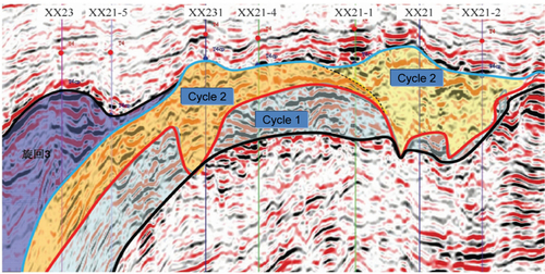
In Well Block XX21, there are three eruption cycles in the volcanic rocks of the Yingcheng Formation. These include the second cycle encountered in Wells XX21-2, XX21, XX21-1, XX21-4 and XX231; the third cycle in Well XX23; and the bulk of the third cycle and the second cycle below 4316 m in Well XX21-5. The first cycle is not encountered by any wells. Thus, the interwell correlation of the volcanic eruption cycle can be established (Figure 3.14).

2) Regional correlation of volcanic eruption cycle based on profile delineation
Built on the interwell correlation pattern, the eruption cycle can be identified and traced in seismic profiles to determine its distribution and contact relationships on the basis of integrated well-seismic calibration and the formation occurrence and seismic reflection within the cycle.
As shown in Figure 3.16, three eruption cycles in Well Block XX21 all show an incline trend to the northwest: the first cycle is composed mainly of volcanic and volcanic sedimentary rocks with laminar reflections of strong amplitude, medium-low frequency, and good continuity in the seismic profile; the second cycle is composed of the volcanic rocks of mixed but mainly effusive facies, and the seismic profile shows reflections of weak amplitude, low frequency, and poor continuity and parallel to subparallel waveform; and the third cycle is composed of interbedded effusive facies and explosive volcanic facies, and the seismic profile shows reflections of strong amplitude, low frequency, and poor continuity and overlies the second cycle in lateral contact.
3) Volcanic edifice as framework constraint of volcanic eruption period
This can be demonstrated using the second cycle as an example. Wells XX231 and XX21 penetrated a large amount of autoclastic lava breccia, which shows almost perpendicular columnar reflections in the seismic profile. In combination with the seismic response of peripheral structures, at least two volcanic edifices were identified as parts of the second cycle in Well Block XX21 (Figure 3.15), thus providing a basis for volcanic period and rhythm division.
2 Eruption period division and correlation constrained by volcanic edifice
A volcanic eruption period reflects the spatiotemporal relationship of the eruption products in different periods separated by dormancy inside the edifice. Under the constraint of volcanic edifice, therefore, the combined interwell pattern of an eruption period can be revealed through single-well identification and interwell correlation. This is followed by well-seismic calibration and volcanic eruption period division in the profile. The volcanic edifice encountered in the second cycle in Well Block XX21 is selected for the division.
1) Single-well identification and preliminary division of eruption period
On the basis of the logging characteristics of single wells, the rock identification can be used to recognize volcanic sedimentary rock, weathered crust, and the transitional interface of lithological assemblage to divide the volcanic eruption period in single wells.
Among the three wells that encountered XX21 volcanic edifice, Well XX21 penetrated a volcanic conduit represented mainly by autoclastic breccia lava. Well XX21-2 encountered mainly welded volcanic breccia and rhyolite, without apparent volcanic sedimentary rock; but the main massifs include two lithological assemblages: volcanic breccia ~ rhyolite ~ tuff lava and volcanic breccia ~ breccia lava ~ rhyolite, corresponding to two eruption periods, respectively. In Well XX21-1, there is a thin suite of volcanic sedimentary rock (3819 to 3823 m) in the second cycle. Thus, the volcanic rocks in this well are divided into two periods, corresponding to the first and second periods in Well XX21-1, respectively.
2) Interwell correlation to determine interwell combination pattern of eruption period
On the basis of single-well identification, volcanic edifice distribution pattern, and variations in lithology and lithofacies, the interwell correlation of eruption period can be conducted to determine the interwell combination pattern of an eruption period.
The XX21 volcanic edifice is formed by a centered eruption, the volcanic conduit lies to the north of Well XX21, and the eruption mode includes alternating explosion and effusion. According to the circular distribution geometry of centered eruption, the interwell combination pattern of the eruption period is established (see Figure 3.16) to form the basis for profile division.

3) Division of volcanic eruption period based on well-seismic combination
Through single-well division and integrated well-seismic calibration, different reflectors are identified in seismic profiles, the local unconformity is traced, and the eruption period within the volcanic edifice is systematically divided.
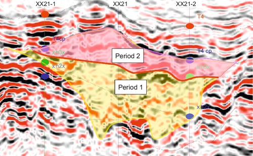
There are two different seismic reflectors inside the XX21 volcanic edifice (Figure 3.17); the upper part shows laminar reflections with strong amplitude, low frequency, and good continuity; the lower part has chaotic reflections with weak amplitude, high frequency, and discontinuity; and the interface shows strong reflections of a local unconformity. The seismic reflection characteristics are consistent with the single-well calibration, and a comprehensive analysis confirms the presence of two eruption periods inside the XX21 volcanic edifice.
3 Rhythm division constrained by volcanic edifice and eruption period
A volcanic eruption rhythm reflects the spatiotemporal relationships between the concentrated eruption products within a volcanic edifice. Due to the minor differences in terms of reflection characteristics and indistinct interfaces inside the volcanic rock, the division of volcanic eruption rhythms can be extrapolated from single-well identification under the constraint of the volcanic edifice and the eruption period.
1) Single-well identification
The division of volcanic eruption rhythms relies on their geological and logging characteristics, as well as the single-well lithological assemblages and logging curve patterns.
Figure 3.18 is an example of eruption period division in Well XX21-2 that encounters the same volcanic edifice in Wells XX21 and XX21-1. Through integrated well-seismic analysis, the volcanic edifice is divided into two eruption periods and six eruption rhythms. The lithology and logging curve patterns indicate that Well XX21-2 encountered four eruption rhythms, from the second to the fifth rhythm. Rhythm 2 is characterized by interbedded volcanic breccia and rhyolite, with logging curves being serrated bell in shape; rhythm 3 consists of interbeds of welded tuff, tuff lava, and rhyolite, with logging curves being microserrated box and bell in shape; rhythm 4 comprises interbedded volcanic breccia and volcanic lava, with some volcanic conduit subfacies, and its logging curves have a serrated bell-funnel shape; rhythm 5 is typified by welded breccia, with logging curves being smooth bell-funnel in shape with good petrophysical properties in the top and bottom parts, but poor petrophysical properties in the middle. The single-well identification lays a foundation for profile division.

2) Profile division
On the basis of single-well identification, seismic reflection variation, the constraint of eruption period, and interactive analysis of interwell correlation and seismic profile tracing, the interwell combination pattern of a volcanic eruption rhythm can be systematically delineated, and the profile division is realized to determine its spatial distribution.
Figures 3.19 and 3.20 are the maps of interwell correlations and seismic profiles for the division of eruption rhythms within the volcanic edifice in Well Block XX21. These maps show two eruption periods inside the volcanic edifice, with three rhythms in each of the periods.
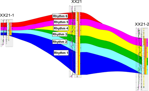
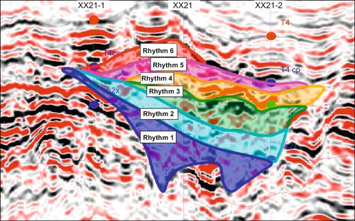
Rhythm 1 comprises two volcanic conduits and the surrounding rhyolite in Well XX21. The conduits are characterized by reflections of weak amplitude, low frequency, and discontinuity and an umbrella-shaped configuration. The rhyolite shows laminar reflections with strong amplitude, low frequency, and good continuity, with a high formation dip angle.
Rhythm 2 is composed of volcanic breccia and rhyolite, with its seismic profile showing chaotic reflections of medium-strong amplitude, high frequency, and poor continuity due to the volcanic conduit. This rhythm unit is encountered in Wells XX21, XX21-2, and XX21-1.
Rhythm 3 is represented by interbedded rhyolite and welded tuff; the seismic profile shows chaotic reflections of medium-strong amplitude, low frequency, and poor continuity, but weak amplitude and high frequency in the volcanic conduit. This rhythm unit is encountered in Wells XX21 and XX21-2.
Rhythm 4 comprises interbedded volcanic breccia and volcanic lava. Due to the presence of volcanic conduit (to the north of Well XX21), the seismic profile shows laminar reflections with strong amplitude, low frequency, and good continuity, but weak amplitude and high frequency in the volcanic conduit. This rhythm unit occurs in Wells XX21 and XX21-2.
Rhythm 5 consists of welded breccia and rhyolite, with laminar seismic reflections of strong amplitude, low frequency, and good continuity. This rhythm unit is encountered in Wells XX21, XX21-1, and XX21-2.
Rhythm 6 is represented by interbeds of welded breccia and breccia lava in Wells XX21 and XX21-1; its seismic reflections are chaotic and of medium amplitude, high frequency, and poor continuity.
The six volcanic eruption rhythms discussed here have contact with each other through paraconformity that can be traced discontinuously in the seismic profile. In the process of eruption rhythm division based on seismic profiles, interwell analysis and seismic profile analysis constrain and supplement each other, and continuous modification and optimization can contribute to appropriate profile division.
Volcanic rock sequence division and correlation form the basis for dividing the development zones, and complex geology and internal architectures are major impeding factors in the technical development of volcanic rock sequence division and correlation. On the basis of a geological analysis of volcanic rocks and architectural characterization, this book develops the techniques of volcanic rock sequence division and correlation, and lays a foundation for analyzing gas and water relationships and optimizing the division of development zones.