
8
Connected Aerials
Feng Xue, Shu‐ping Yeh, Jingwen Bai, and Shilpa Talwar
Intel Corporation, Santa Clara, CA, USA
Abstract
To operate drones safely and to accomplish various missions, wireless technology is a critical component in control and command. This chapter discusses basic requirements and challenges for supporting drones over a cellular network. It provides a quick summary of drone regulations, which serves as a good indication of challenges in supporting drones and innovation in communications. The chapter reviews 3GPP Release 15 drone study and WIs the first on drones in 3GPP. It provides a 5G drone support deep dive discussing challenges in supporting various drone uses, solutions from new technologies in 5G, and new studies needed for further 5G innovation toward future drone usages. Many drone applications, such as surveying, require 3D positioning support. Since cellular networks have always focused on serving terrestrial users and mostly use down-tilted base station antennas, aerial coverage and link qualities need to be carefully studied and optimized for drone support.
Keywords aerial communication; aerial coverage; cellular network; drone regulations; drone usages; terrestrial users
8.1 Introduction
In recent years, aerial vehicles (AVs) such as UAVs (unmanned aerial vehicles, also known as drones) have experienced exponential growth, and many innovative usage scenarios are being considered. For example, drones can be used for surveying, search and rescue, maintenance and repair, safety, communications, image capture, surveillance, etc. These non‐conventional usages are useful for many industries such as energy (oil/gas/wind/solar), insurance, telecom, agriculture, shipping, wildlife and environment research, sports, and so on. In many cases, drones could fundamentally transform the industry. Even more futuristic, UAVs are being considered as air taxis to transport humans [1].
To operate drones safely and to accomplish various missions, wireless technology is a critical component in control and command (C2). Currently, the control is typically based on RC (remote control) channel, WiFi and/or Bluetooth, which have limited data rate and transmission range. Since most countries allow only visual‐line‐of‐sight operation of drones now, they may satisfy the immediate needs. However, with so many emerging drone applications and in anticipating future new regulations, the cellular system has been under investigation to support increased requirements on reliability, large scale operation, and high data rate. This is because there are many benefits by utilizing a cellular network:
- With licensed spectrum and well controlled infrastructure, a cellular network can provide dedicated resources for QoS (quality of service) guarantee, especially for reliability and high data rate. This is in great contrast to WiFi/Bluetooth solutions which are on a shared spectrum.
- A cellular network is widely deployed and well connected via fast speed backhaul links. It not only provides data services but also provides services such as positioning, identification, etc. over a large area. These services with reliability make it a good candidate as an infrastructure for supporting large‐scale and dense operations; it is also a good candidate for autonomous non‐visual line‐of‐sight operations.
- Besides WiFi/RC/Bluetooth‐based solutions, a cellular network provides further redundancy to increase reliability which is much needed for the safe operation of drones.
Given the above considerations and huge business potentials, both academia and industry have taken efforts to understand the support of drones over 4G and 5G systems. As one of the important 5G vertical usages, system requirements related to drone cases have been incorporated into 5G system design requirements [2]. Performance impact and challenges due to drones have been studied in 3GPP Release 15 WIs [3], resulting in the introduction of a set of features for continuous 4G/5G evolution. With many new technologies introduced, 5G cellular will enhance the support of drones with more advanced interfaces such as ultra‐reliable and low‐latency communications (URLLC). Millimeter wave (mmWave) may satisfy the need of large capacity for transferring a large amount of data from drone to ground (e.g. 4K/8K video). Interestingly, 5G development will also benefit from the continuous development of new drone usages. For example, drones may be employed to serve as flying cells for temporary coverage enhancement.
The chapter is organized in the following way. Section 8.2 discusses basic requirements and challenges for supporting drones over a cellular network. Section 8.3 provides a quick summary of current drone regulations, which serves as a good indication of challenges in supporting drones and innovation in communications. Section 8.4 reviews related R&D efforts, focusing on communications from both academia and industry. Section 8.5 reviews 3GPP Release 15 drone study and WIs – the first on drones in 3GPP. Section 8.6 provides a 5G drone support deep dive discussing challenges in supporting various drone uses, solutions from new technologies in 5G, and new studies needed for further 5G innovation toward future drone usages.
For ease of reading, the acronyms used have been summarized at the end of the chapter. Note in many places the words UAV, drone, and aerial are interchangeable.
8.2 General Requirements and Challenges for Supporting UAVs over a Cellular Network
AVs, even though in a certain sense they can be considered as a subset of autonomous vehicles, have several unique properties compared with traditional terrestrial users and other verticals. This makes them a unique category worthy of special consideration in 5G.
First of all, the drone activity region could be far above ground level. In current regulations, drones are allowed to fly 100–300 m or even higher depending on the country’s regulations. Since cellular networks have always focused on serving terrestrial users and mostly use down‐tilted base station antennas, aerial coverage and link qualities need to be carefully studied and optimized for drone support. As measurements have shown, drones cause and receive excessive interference due to slower signal attenuation in the air compared with on the ground. In addition, as illustrated in Figure 8.1, antenna side lobes complicate the situation further [3] due to their fast and irregular fluctuations.
AVs can continuously move at fast speed in the sky over a large area. Although it might seem that challenges in mobility support may have some similarity to ground vehicle scenarios, there are some differences. First, the drone movement is 3D. Drones could be moving in any arbitrary fashion without the constraint to be along predefined routes like ground vehicles. Unique properties of the aerial channel also play a role. Due to nicer propagation properties in the air, a drone sees a larger number of base stations than a car on the ground as verified by both measurements and simulations. As it is supported by the side lobes, signal qualities from many far away base stations are comparable with local ones. Thus a fast‐moving drone can experience communication links with rapid fluctuation in quality. Thus, careful design of drone mobility support is needed.
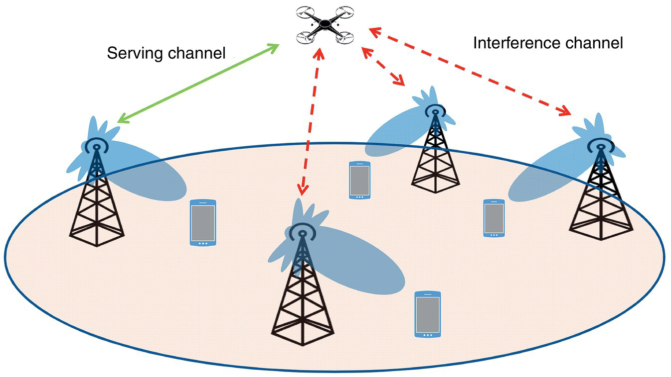
Figure 8.1 Interference situations in the air for drones.
Many drone applications, such as surveying, require 3D positioning support. Accurate positioning is particularly important for safety‐critical procedures, such as fly planning and collision avoidance. Even though positioning can be provided by GPS in an outdoor case, redundancy is needed as GPS could be subject to blockage and/or multipath in many scenarios.
Special traffic pattern in drone usages may also demand enhanced wireless support. Contrary to the traditional view that the cellular network is dominated by downlink traffic, uplink data traffic is dominant in many drone use cases when drones need to send high quality video streams to users or data centers. Communication support for edge‐computing needs to be addressed as well. For example, in the case of real‐time surveillance, a drone's video stream needs to be processed for real‐time reasoning. This involves both data analytics and machine learning at the edge.
Public safety is another key concern regarding drones. Regulation agencies have been considering possible solutions for ensuring public safety. 4G/5G cellular systems can enhance identification, localization, geo‐fencing, etc. As more advanced operations such as beyond‐visual line‐of‐sight, drone swarm, and air taxi come into the picture, requirements on extra reliability, throughput and computing support from the cellular systems are significantly increased. More details on these emerging operations will be discussed later.
Summarizing these observations, the following are several basic challenges to be considered and enhanced for supporting drones on cellular networks:
- Interference mitigation
- Mobility support enhancement
- Latency and reliability
- 3D Positioning
- Enhanced throughput in uplink
- Edge computing support
- Safety
8.3 Summary on Current Drone Regulations
Regarding communication support, most wireless technologies such as PAN and WAN have been designed and regulated based on terrestrial uses. Spectrum allocations and regulations are under investigation for aerial usages.
Regarding drone operation regulation, there have been early developments. In the United States, the Federal Aviation Agency (FAA) established a set of rules on small drones between 0.5 and 55 lb in Part 107 [4] in 2016. It sets very restrictive constraints on how one can operate drones and is representative of regulations across the globe. The following are a few samples from Part 107:
- Non‐visual‐line‐of‐sight operation is not allowed.
- One pilot cannot operate more than one drone.
- Drone cannot fly over 400 ft. above ground or a building.
- Drone speed should be less than 100 miles per hour.
In other countries such as Canada, China, Japan, and the EU, similar rules have been implemented (e.g. China [5]). All are in an early stage as drone operation scenarios are still undergoing fast changes and growth. Safety has been a main concern. In the meantime, various programs have been set up to encourage drone innovations in the future.
8.4 Review of Aerial Communication R&D Activities in General
8.4.1 R&D Activities from Industry and Government Agencies
The communication link for current drones is typically based on RC, WiFi, Bluetooth, and other technologies on the ISM‐Band. Their limitations are obvious in terms of capacity, reliability, distance, and safety. Efforts have been taken by industry and government agencies to enhance the communication links via several methods.
Qualcomm established a flight test site around its headquarters to study how 4G/5G can help drones [6], with results summarized in [7]. In [8, 9], it claims that “5G will enable wide scale deployments of mission‐critical drone use cases.” DJI and several startups introduced proprietary solutions to enhance video streaming quality and control distance. AT&T considered improving Long‐Term Evolution (LTE) coverage for both ground users and drones at packed venues such as sport activities or in a disaster zone [10]. Verizon kicked off an Airborne LTE Operations (ALO) initiative in October 2016 for innovation on in‐flight wireless connectivity.
GSMA [11] and CTIA [12] have published white papers with partner companies claiming and promoting improved drone support over cellular networks. Based on field study, the Civil Aviation Administration of China [13] clarified a set of requirements on operation of drones and claimed cellular infrastructure to be a good candidate for safe drone operation. 3GPP completed an aerial specific Study Item (SI) and Work Item (WI) in RAN1/RAN2 in 2017–2018 [14], and also started working on drone ID at core network side [15].
In existing cellular networks, many spectrum regulations/allocations are based on terrestrial considerations. For example, mmWave on 60 GHz is prohibited in the US for use in the air. In consideration of drone development, the US Federal Communications Commission (FCC) has been carefully monitoring the activities. In August 2016, the FCC TAC (Technological Advisory Council) organized a meeting to collect input on UAS communication‐related regulation. The “UAS” here is under broader definition and includes even low‐orbit satellites. Many companies proposed a dedicated spectrum for control, while observations on using a cellular system were also shared. In 2018, the FCC initiated a TAC UAS Working Group which includes a Spectrum Subgroup. In the EU, similar activities are on‐going. Recently [16], a new ECC report “Use of MFCN for UAS operations” was initiated, where 26 GHz is being considered for drone to ground communications.
Anticipating fast growth, R&D on drone technologies are encouraged by US federal agencies such as the FAA, Department of Transportation, and NASA. For example, the FAA allows special permits for testing new technologies, and several test sites have been established. Many companies have partnered with the FAA, such as CNN and PrecisionHawk, on different usages [17]. US NASA started an effort in late 2014 on UAS traffic management (UTM) [18]. The target is to enable large scale and safe drone deployments in low‐orbital environments. In its vision, the system will coexist with today's manned aircraft management system, and will provide service at national scale. In November 2017, the US Department of Transportation announced a drone Integration Pilot Program (IPP) [19]. The purpose is to encourage local governments, industry, and academic partners to experiment with new innovations and usages on drones.
8.4.2 Academic Activities
There is also active research in academia on AVs, spanning from aerodynamic, communications, to economics. Here we focus on the wireless communication aspect.
A large portion of the research studied how to support drone communication/control links using WiFi, 802.15.4, remote control channel (e.g. [20–24]) due to the spectrum availability. Aspects such as link quality, interference, requirements, antenna impacts, etc. have been considered. Many of the findings are relevant for cellular‐based solutions as well. In particular, field experiments from [22, 23, 25] showed the importance of antenna design and pattern. It was shown that antenna nulls and direction could cause throughput loss. In [21, 22], the authors investigated WiFi protocols and discussed challenges due to mobility, heterogeneity, antenna, blockage, constrained resources, and limited battery power.
Reference [26] reviewed and compared the existing technologies, including 802.15.4, 802.11, 3G, LTE, and infrared. In [24], some of the drone applications (search and rescue, coverage, construction, and delivery) were compared in terms of constraints, assumptions, mission requirements, etc. Several works have also studied providing drone communication through wireless cellular infrastructure. Reference [27] investigated the interference problem when drones are present. It validated that the portion of interference coming from drone user equipment (UE) also depends on the 3D angle of arrival at the ground base station due to its antenna pattern and the interference to drones varies with altitude. In reference [28], cellular coverage was investigated in an isolated area. It was shown that the nulls in between side lobes create “holes in the sky.”
A tutorial on drone‐based wireless networks ([29] and references therein) has provided a comprehensive overview on the use of drones for wireless communications. The potential, state‐of‐the‐art research achievement and challenges for a drone‐based wireless system are discussed in the following areas: (i) coverage and capacity enhancement of beyond a 5G wireless network for supporting drone UEs, (ii) usage of drones as flying base stations for providing cellular service, (iii) integration on drones for Internet of Things communication, and (iv) usage of drones as flying backhaul to assist terrestrial networks.
8.4.3 3GPP Activities in General
Observing the rise in aerial markets, 3GPP initiated multiple activities to investigate how cellular networks should evolve to support reliable communication for diverse drone applications. Starting from defining drone use cases and service requirements, the 3GPP standard body identified the key challenges in supporting drones via LTE networks and further developed multiple candidate solutions to enhance LTE drone communications. Several working groups (WGs), mainly for the service and system aspects (SA) and radio access network (RAN) technical specifications, are involved in the cellular drone support discussion.
In the report of new service and market technology enablers for next generation mobile communication from 3GPP SA WG1 (services focus) [30], drones and robotics applications are identified as important usage cases in the category of critical communications. In [31], more in‐depth descriptions on usages and requirements for drone applications are provided. The specification lists multiple drone usages with higher requirements on reliability, latency, service availability and/or positioning accuracy. In general discussion of service requirements for the 5G system [2], drones are also mentioned as new usages that can possibly impact 5G requirements.
In terms of supporting drone via LTE, the 3GPP RAN WG1 (physical‐layer focus) and WG2 (medium access control and radio resource management layers focus) started a SI on enhanced LTE support for AVs in March 2017 [14]. The main outcome of the SI is captured in [3]. The report identifies key challenges in LTE drone support as well as providing an extensive list of candidate solutions for interference mitigation and mobility management for drones. Multiple companies provided simulation results and field trial data on LTE performance while supporting drones. After the SI completed in December 2017, a follow‐up 3GPP RAN WI [15] continued to further enhance the LTE support for AVs. The WI successfully made several critical spec changes to enhance drone support, such as extending the parameter range for uplink power control, including 3D position information in the measurement report, height‐based triggering for measurement reports, and signaling of flight path information.
In addition to supporting drone applications, 3GPP also investigated non‐terrestrial networks (NTNs) that use satellites or air‐borne vehicles such as high‐altitude drones to provide 5G service. Multiple satellite and aerial access network architectures are identified. The study also discussed frequency bands, radio characteristics, propagation delay and Doppler modeling for NTNs. Detailed results from the study can be found in the summary report [32].
In 2018, 3GPP SA1 also started an SI on drone identification for safe drone operations [33]. In this study, new architecture and service designs are being considered for the core network to enable safer and secure operations.
8.5 3GPP Enhancement on Supporting Drones
In this section, we discuss more details on the observations and technology development in 3GPP for supporting drone communication. Several recent papers have also summarized the effort (e.g. [34]).
8.5.1 3GPP Drone Study Item and Work Item in RAN1
In this subsection, we focus on the 3GPP enhancement specification for drones in both SI and WI from the RAN1 perspective.
The SI aims to investigate the feasibility of serving AVs using LTE network deployments with base station antennas targeting terrestrial coverage, supporting Release 14 functionality (including active antennas and full‐dimension multiple‐input multiple‐output [FD‐MIMO]). The objectives of the study were to verify the level of performance, identify supportable heights, speed, and densities of AVs, select air‐to‐ground channel models, and study performance enhancing solutions for interference mitigation, etc.
Three deployment scenarios were considered in the SI for the system performance evaluation:
- Urban‐macro with aerial vehicles (UMa‐AVs) where base station antennas are mounted above rooftop height of neighboring buildings in an urban environment.
- Urban‐micro with aerial vehicles (UMi‐AVs) where base station antennas are placed below rooftop.
- Rural‐macro with aerial vehicles (RMa‐AVs) where base station antennas are mounted on top of towers in a rural environment with larger inter‐site distance separation.
In all the scenarios, drones are modeled as outdoor UEs with height uniformly distributed between 1.5 and 300 m above ground level (AGL).
For channel modeling, terrestrial users follow [35], while for AVs, new channel models are specified to characterize the channels between aerial UEs and eNodeBs regarding line‐of‐sight probability, pathloss, shadow‐fading, and fast‐fading. Some of the key parameters are explained in Table 8.1. Other details can be found in [3].
Table 8.1 Channel model assumptions for aerial vehicles.
| Parameter | Assumption |
| Line‐of‐sight probability | Height‐dependent and line‐of‐sight probability increases as height increases |
| Pathloss and shadow‐fading models | Follow tables B‐2 and B‐3 in [3], respectively |
| Fast‐fading model | Three alternatives are agreed |
| The first one is based on a clustered delay line model | |
| The second one has adopted aerial UE height dependent modeling methodology for angular spreads, delay spreads, and K‐factor | |
| The third one reuses the fast‐fading model in [35] with the K‐factor modified to 15 dB |
Based on the above‐mentioned scenarios and channel models, system performance is evaluated and increased network interference are observed in both uplink and downlink in the presence of aerial UEs. Due to the favorable line‐of‐sight propagation environment, aerial UEs in the sky can cause more uplink interference, and also suffer strong downlink interference from neighboring base stations. These problems will become more severe as the density of the aerial UEs increases, leading to significant overall signal‐to‐interference‐plus‐noise ratio (SINR) and throughput degradation. Hence, several interference mitigation methods are proposed including both implementation‐based solutions and those requiring specification enhancements [3].
For example, to address downlink interference, intra‐site joint transmission coordinated multipoint (JT‐CoMP) can be applied where multiple cells belonging to the same site are coordinated and data is jointly transmitted to the UEs. Besides, coverage expansion has been proposed to enhance synchronization and initial access for aerial UEs.
As for mitigating uplink interference, uplink power control schemes with specification enhancement can be adopted, such as optimizing UE‐specific open‐loop power control parameters, and setting wider step size for the transmit power control command in the closed‐loop power control.
In addition, FD‐MIMO can be used without specification enhancement to mitigate both uplink and downlink interference. Employing directional antennas at aerial UEs is another effective approach in reducing the increased interference in both uplink and downlink, as demonstrated in [3].
In the WI following the completion of SI, new features are specified to further improve the efficiency and robustness of terrestrial LTE network to deliver connectivity solutions for drones. One of the objectives for RAN1 in the WI is to specify uplink power control enhancements. In LTE, fractional open‐loop power control is introduced, where the UE transmit power per resource block is determined by
where Pmax is the maximum UE power, P0 is a target received power level, α is the fractional pathloss compensation factor, and PL is the pathloss component. The current LTE spec supports only cell‐specific α, cell‐specific P0 ∈ [126, ⋯, 24] and UE‐specific offset ∈ [−8, ⋯, 7].
To enable more flexible uplink power control to cope with dynamic interference in the presence of drones, RAN1 has focused on the following areas for uplink power enhancement: (i) introducing UE‐specific fractional pathloss compensation factor, and (ii) extending the range of UE‐specific P0 parameter. At the end of the WI, the following new features are introduced to Release 15:
- The range of UE‐specific P0 parameter is extended to [−16, ⋯, 15].
- The aerial UE can be RRC configured with a single UE‐specific α parameter for PUSCH.
- The UE‐specific α overrides the cell‐specific α once it is configured.
- The support of UE‐specific α and the extended range of UE‐specific P0 are optional with capability signaling.
8.5.2 3GPP Drone Study Item and Work Item in RAN2
During the course of the WI for enhanced LTE drone support, RAN2 made multiple specification modifications to improve aerial communication links. The most important changes are related to airborne status indication, mobility management, interference detection and message overhead reduction. RAN2 defined signaling for indicating airborne or not, which is useful for identifying aerial users and then applying interference mitigation and mobility management enhancements. From the new spec, reference altitude information can be provided by eNB to aerial UE to assist UE on identifying its status.
From the RAN2 perspective, mobility management is the most critical challenge for reliable drone support. Simulation results [3] show aerial users 50–300 m above the ground experience higher handover failure rate than terrestrial users. As drone speed increases, all companies observe more frequent handover failure. Most results indicate that mobility management for drones needs to be improved in order to reliably support drone applications.
Fortunately, unique drone communication properties can be utilized to assist mobility management. Figure 8.2 shows how the reference signals received power (RSRP) from the upper‐right sector of the central base station decays over an area covered by 57 cell sectors. The results are obtained based on 3GPP simulation assumptions [3] for different UE altitudes. The geographical heat map of UE wide‐band SINR over three cell sectors is plotted in Figure 8.3. Note that the shaded scales are all different. These figures show that channel quality for aerial link can fluctuate rapidly as drones move. There are regions in the sky with very poor channel quality to support satisfactory connection for drones. On the other hand, the statistics also suggest that aerial channels are less likely to be obstructed by objects. Compared with shadowing effect, the antenna pattern at the base station has more impact on aerial channel fluctuation. In other words, wireless link quality for drones is likely to be predictable based on location information. In addition, the height information can be useful to the network for selecting RAN parameters for drones. As a result, RAN2 approved to include 3D position information in the measurement report and enable drones to provide flight path trajectory to the network. New height‐based measurement report triggering events, where vertical speed can be sent along with location information in the height report, are also introduced in Release 15 specifications.
Another focus in RAN2 is interference detection mechanism and message overhead reduction for aerial UEs. Statistics from RAN1 study show that interference is the critical limiting factor to drone throughput. With enhanced interference detection mechanism, cellular systems can timely apply the right interference mitigation schemes developed from RAN1 study to improve drone connection. For example, a good interference detection mechanism can help quickly identify strong interfering neighbors to be muted when enhanced inter‐cell interference coordination (eICIC) is used for aerial UEs. However, aggressive interference detection mechanism can cause excessive measurement report which is not desirable. In addition, as mentioned in Section 8.5.1, aerial users tend to observe more interfering neighbors due to the highly probable line‐of‐sight propagation environment which leads to unnecessary measurement reports triggering.
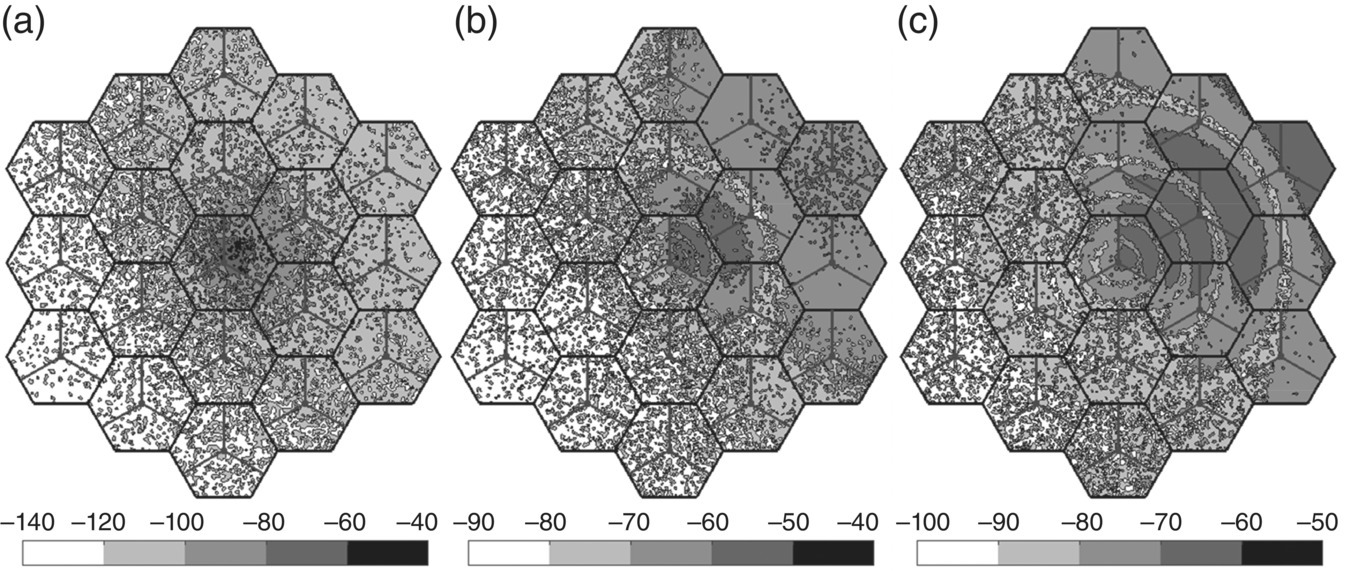
Figure 8.2 Geographical RSRP heat map at different altitudes: (a) ground level; (b) 100 m above ground; and (c) 300 m above ground. The plots show the RSRP from the upper‐right sector of the central base station, as indicated by small triangles, measured over a geographical area of 19 cell sites (total 57 cell sectors).
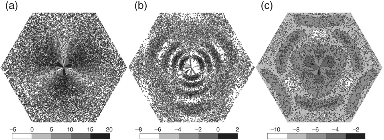
Figure 8.3 Geographical wide‐band SINR heat map at different altitudes: (a) ground level; (b) 100 m above ground; and (c) 300 m above ground, over a geographical area of 1 cell site (3 cell sectors).
RAN2 thus targeted to adjust existing protocols to avoid excessive signaling overhead while maintaining best interference detection efficiency. Based on observations from aerial UE interference characteristics, RAN2 agrees to introduce a new parameter for measurement report triggering: the number of cells satisfying the condition of measurement trigger event. Only when an aerial UE observes at least the specified number of neighbor cells satisfying the triggering condition, a measurement report will be sent. The new multi‐cell trigger mechanism can significantly reduce the number of measurement reports from aerial users.
8.6 5G Challenges, Solutions, and Further Studies
As 5G is emerging with advanced capabilities and more spectrum, it becomes a natural choice to cater for the demanding needs of aerial verticals. In this section, we expand the discussions on the unique properties of drones and elaborate on emerging new usages in the 5G era. Then we discuss how these properties link to key performance indicators (KPIs) such as throughput, reliability, positioning etc. and how existing 5G features help resolve the challenges. As AVs constantly evolve in terms of new usages, regulations, etc., we also discuss how future 5G could be continuously enhanced.
8.6.1 Challenges, New Emerging Usages, and Requirements for 5G
There are several unique and large verticals that 5G is trying to support, such as connected automobiles, connected industry, and connected health. AVs represents a new and emerging vertical with unique usages and requirements.
In Section 8.2 we identified several unique properties and challenges inherent to AVs: severe interference, irregular side lobes, mobility challenge, positioning need, and more focus on uplink. In the 5G era, these requirements continue to hold and will get tighter as the deployment scale and density continue to increase.
In addition to the above, at the beginning of 5G development, several new usages were considered in defining general 5G requirements. In 3GPP TR 22.862 “Enablers for Critical Communications,” several use cases are discussed based on expected drone usages. These requirements were combined with other verticals and uses, and were characterized in the 5G requirement document TS 22.261 [2].
Particularly in TR 22.862, requirements focusing on latency, reliability, and availability were discussed based on several sets of usages. A major example of future drone uses is when a local team of drones collaborate as a sensor/actuator network. In this example, the drones need to work in uncertain and dynamic environments while being controlled by an operator. This could be used for, e.g. surveillance, collaborative mapping, and object manipulation. To enable such operations, one needs node‐to‐node communications, mesh networking, and end‐to‐end connectivity and reliability. This leads to the needs of continuous wireless coverage for UAV flying between 10 and 1000 m with maximum speed of 200 km/h. A 5 ms latency is needed for node‐to‐node links.
A second set of usages discussed in TR 22.862 centers around positioning requirements for low altitude UAV in critical condition. This includes package delivery, emergency surveying, and sensing by a team of drones. To satisfy these needs, high positioning accuracy, e.g. 0.5 m in both indoor and outdoor, along a density up to 1 million devices per square kilometer and with high mobility are needed [31].
Besides the above, new technology and uses of AVs are being developed constantly. There are several use cases in their early infancy that are already getting a lot of attention:
- Drone swarm on a large scale and with high density is one example. One use case is to deploy hundreds of drones for rescue after a natural disaster. Compared with a small team of drones as mentioned above in TR 22.862, large drone swarm use case expects drones to work more intelligently and collaboratively, in real time both locally and globally. This exerts stringent requirements on all aspects of wireless communications such as peer‐to‐peer, backhaul, and positioning and controls.
- Augmented reality and virtual reality applications with drones are another unique set of applications. In this use case, a team of drones can record videos of a scene in real‐time, process and transmit data back to one or a set of end users for entertainment (e.g. Olympics) or for remote control of a rescue task in a dangerous environment. These tasks require optimized tradeoff between local processing on the device, edge computing for more complex tasks but short latency, and global optimization in a data center with longer delay.
- Another emerging usage of AVs is human‐lifting “air‐taxi” UAVs. Uber, Airbus, and Ehang are experimenting with UAVs for urban mobility, where a human can hire a drone as a taxi. Besides, there are also many startups experimenting with flying cars. This new usage sets extra requirements on reliability, safety, and computing support.
Besides these new use cases, concerns on public safety also introduce new requirements. Methods to identify a drone, to enforce air‐space protection (e.g. geo‐fencing) are urgently needed. Recently 5G SA1 approved a new item on studying drone IDs [33]. Several studies have come to realize that a cellular system, especially 5G, can serve as a “natural” infrastructure for providing such support.
Many of the aforementioned requirements can be addressed by focusing on enhanced basic KPIs such as throughput, latency, reliability, and positioning accuracy. Yet the connection between certain needs and basic KPIs may not be straightforward as new use cases develop.
8.6.2 3GPP Features Addressing These New Requirements
5G introduces many new features compared with 4G. These include particularly, among others, enhanced mobile broadband (eMBB), URLLC, and massive machine type communications (massive MTC). It also introduces a vast amount of spectrum in the mmWave band and enhanced V2X (vehicle‐to‐everything) support. At the core network side, network slicing via advanced network function virtualization (NFV) allows flexible and dedicated solutions toward supporting drones. Computing power for each local area is also enhanced for more powerful edge computing. These provide great potential in supporting AVs by addressing the challenges identified earlier.
In characterizing how 5G features can enhance drone support, one should keep in mind two very different types of links for AVs: command and control (C2), and data (Data). C2 is essential for drone operations such as fly control, collision avoidance, etc. It typically does not require high data rate, and the focus is reliability and low latency. Depending on the usage scenarios, requirements might be different. In 3GPP study, one typical assumption is that the data rate is 50–200 Kbps. On the other hand, the “Data” link is mainly needed for non‐control traffic, e.g. video streaming. It needs large throughput but, depending on exact usage, may relax relatively on latency. In certain cases, such as augmented reality and virtual reality, both high data rate and low latency may be required.
8.6.2.1 eMBB
Technologies behind eMBB significantly enhance both C2 and Data links for AVs. First of all, eMBB provides links with extremely high data rate, e.g. Gbps, via technologies such as massive MIMO and mmWave. For AVs, this provides fast uplink and downlink for data intensive applications, helping answer the challenge to deliver air‐to‐ground high quality video streams. Flexible beamforming for both low band and mmWave allows good support even when drones are moving fast.
In both low band and mmWave bands, new technologies provide much sharper beams compared with 4G. With beam scanning and tracking interfaces, this alleviates the interference issues in 4G and earlier generations due to the broadcast nature of wireless communications. In particular, in low band, massive MIMO, a continuation of FD‐MIMO, allows better resolution in the vertical domain, suited nicely for drones flying in 3D space. In mmWave band, besides much narrower beams, the form factor shrinks down significantly, allowing UE (such as drones) to be equipped with mmWave arrays for uplink beamforming and tracking.
Technologies behind eMBB also answer the C2 and positioning challenges of drones. Narrower beams with 3D beam scanning and tracking leads to less interruption for the control and command links. Wide bandwidth and dominant line‐of‐sight propagation inherent in mmWave allow more accurate positioning.
8.6.2.2 URLLC
5G provides new flexible interfaces to shorten the latency and improve reliability compared with 4G. In addition to HARQ, 5G introduces short transmission time interval (TTI), reducing from 1 to 0.125 ms in 5G NR [36]. For dynamic uplink scheduling or contention‐based access, 5G now allows grant‐free access without resource reservation via the network. The shortened response time provides solutions to mission‐critical drone controls such as remotely controlled drone team/swarm activities.
Reliability is enhanced several ways in 5G. Control channel design is very different compared with 4G. Now UE specific signaling based on downlink channel quality allows adaptation of MCS (modulation and coding set) to each UE's channel condition and latency budget. Multi‐RAT between mmWave, low band, LTE, and other technologies allows broader diversity. For example, low band can be dynamically switched on when mmWave is blocked by an obstacle. These designs address the reliability requirement specified by 5G requirements in TR 22.862 for Critical Communications. For aerial vertical, it provides safety and reliability to support fast mobility in the air. This is more pronounced in the case when a drone is used as an air taxi.
8.6.2.3 Massive Machine‐Type Communications
This provides services for a very large number of devices with relatively low requirement on, e.g. latency, and with high density (e.g. 100 million devices per square kilometer). These devices typically need to have long battery life and with low cost – supporting the vision of the Internet of Things. To address these special needs, 5G designs provide several solutions. For example, 5G allows grant‐free and asynchronous access, shorter TTI, and massive MIMO. These considerations and designs conveniently help the aerial vertical usage as well. They are suited for geo‐fencing, large drone deployment with low data rate (e.g. Control and Command), drone swarms, drone IDs, and drone operations over large sensor networks.
8.6.2.4 V2X
Continuing existing work from LTE, 5G has been enhancing V2X designs in sync with the revolution of autonomous driving. Release 14 provides enhanced range and reliability with high density support. It also reuses DSRC/C‐ITS higher layers, and, for lower layer, V2X can coexist with 802.11p on the ITS band. As an integral component, V2X provides support on safe operations such as collision warning, sensor sharing, intention/trajectory sharing, wideband raging and positioning, and local maps. Although these new features were targeted for cars, they naturally enhance drone support in the 5G era. Nevertheless, further evaluations and new design considerations need to be carefully done for drones under the corresponding channel models and deployment.
8.6.2.5 Next Gen Core Network
5G core network designs provide true flexibility in supporting many use categories. This is achieved by software defined networking (SDN), NFV, network slicing, and cloud RAN. Network slicing allows different network segments to be configured as needed for providing differentiated end‐to‐end services. This provides a framework for optimized AV support in cross‐layer and end‐to‐end fashion. Furthermore, a private network may be an option for dedicated service.
8.6.2.6 Positioning
Positioning is essential for AV operations in 3D space, especially for safety. For example, in geo‐fencing, drones need to operate within a specified region or not to enter a protected region. In multi‐drone operation and autonomous operation, positioning is a basic function for collision avoidance or cooperation, between drone to drone or drone to other objects. 5G continues to enhance higher resolution of UE positioning. Sub‐meter accuracy is expected with wider bandwidth and better signaling. This, combined with advanced features from V2X such as interfaces for vehicles to share their positions more accurately and frequently, will enhance AV operations dramatically.
8.6.3 Further Study Needed for Aerial Vehicles in 5G
Even though current 5G features seem capable of solving many challenges for supporting AVs, unique properties of drone applications were not carefully considered when basic 5G requirements and structures were established. Most 5G designs have been focusing on ground users in contrast to aerial users in 3D space with high mobility. Therefore, new studies are required in future 5G evolution for better support of aerials.
As discussed earlier, 5G RAN1 and RAN2 support both FD‐MIMO and massive MIMO. Yet, the parameters for the control and basic public channels were designed and evaluated mostly based on UEs on or close to the ground. Given excessive interference from drones in the air, the capacity of such channels may be limited. Careful study on such basic channels with possible enhancement in the vertical domain is needed. The tradeoff between supporting aerial users and terrestrial users is a key concern. More flexible design allowing real time adaptation may be needed depending on the combined traffic pattern.
Another challenge for eMBB regarding drones is the applicability of mmWave on airborne drones. Current regulations are very restrictive on mmWave transmission for a mid‐air vehicle. Future regulations need to be studied and relaxed for aerial usage. Currently US FCC and EU agencies have started investigating such possibility. For example, 26 GHz has been discussed for possible drone to ground usage in the EU.
Release 15 drone study introduced RAN2 enhancement for supporting drones. For example, drones can provide flight information to the network, so that the latter may utilize it to optimize communication support accordingly. Even though discussions were held for height‐based optimization, coherent conclusions on how to enhance support were not reached. Future research remains to be done to best utilize these new features in Release 15 and to discover new mobility enhancement strategies.
Regarding URLLC to AVs, more careful designs should be considered. The aviation community needs to be brought in for addressing aviation considerations such as traffic management and coordination with manned aircraft. For example, in normal aerial operation, safety mechanisms are not designed based on assuming a ms‐level communication latency. Many on‐board mechanisms, such as collision avoidance via sensing, are in place for safe drone operation. On the other hand, for future usages such as high‐density drone operation with remote control, such low latency is required. URLLC with specialization for UAVs is needed to support different use scenarios such as: (i) safe drone operation with single unit, (ii) drone operation with multiple or dense drones, and (iii) drones as tools for other usages such as in rescue tasks.
In practice, several generations of cellular network coexist at the same time, and there are coverage issues in rural areas. Wireless support for drones needs to carefully consider coverage issues and multi‐RAT. Combinations between 5G with 4G or even 3G will provide different levels of support. Multi‐RAT with, e.g. PAN/LAN, or their specialized versions, is needed for safe aerial operations with reliability and redundancy. Furthermore, the UTM system has been considered by many to be the future drone operation model, in coexistence with manned air traffic. Combining UTM and 5G may provide benefit for both sides. Actually, 5G has been considering drone ID in SA1 study [33] and integration of aerial support functions to core network can be one option. A good question is how one should split the solutions between radio link, core network, and over‐the‐top application layers.
As safety is a key concern for aerial operations, 5G and earlier generations can be utilized to provide further support for safe operation. For example, mmWave equipment on the base station towers entails a possibility of new signaling and feedback design for detecting objects in the air similar to radars, thus providing a new functionality besides communication.
Finally, AVs can also be part of 5G infrastructure. As they can be deployed on demand and to areas without fixed infrastructure, drones can be used to help improve/recover cellular coverage. They can serve as flying cells, backhaul, or relays in situations such as disaster recovery and sport events. With a non‐conventional 3D network in mind, new designs and investigations are definitely needed.
Acronyms
- 3GPP
- Third Generation Partnership Project
- CTIA
- Cellular and Telecommunications and Internet Association
- ECC
- European Electronic Communications Committee
- FAA
- Federal Aviation Agency
- FCC
- Federal Communications Commission
- GSMA
- GSM Association
- LTE
- Long Term Evolution
- MCS
- Modulation and coding set
- NASA
- National Aeronautics and Space Administration
- PAN
- Personal area network
- PUSCH
- Physical uplink shared channel
- QoS
- Quality of service
- RAN
- Radio access network
- RC
- Remote control
- SI
- Study Item
- TTI
- Transmission time interval
- UAV
- Unmanned aerial vehicle
- UE
- User equipment
- WAN
- Wide area network
- WI
- Work Item
References
- 1 Uber Elevate (2016). The future of urban mobility. https://www.uber.com/info/elevate (accessed 14 October 2019).
- 2 3GPP TS22.261 (2018). Service requirements for next generation new services and markets.
- 3 3GPP TR36.777 (2018). Enhanced LTE support for aerial vehicles.
- 4 FAA (2018). Part 107. https://www.faa.gov/uas/media/Part_107_Summary.pdf (accessed 21 September 2018).
- 5 China Civil Aviation Bureau (2015). Interim regulations on UAS.
- 6 Qualcomm (2016). Qualcomm and AT&T trial drones on cellular network. https://www.qualcomm.com (accessed 14 October 2019).
- 7 Qualcomm (2017). LTE unmanned aircraft systems, trial report v1.0.1, May 2017.
- 8 Qualcomm (2016). Accelerating integration of drone into the cellular network. FCC TAC Meeting, August 2016.
- 9 Qualcomm (2018). Leading the world to 5G: Evolving cellular technologies for safer drone operation. https://www.qualcomm.com/documents/leading‐world‐5g‐evolving‐cellular‐technologies‐safer‐drone‐operation (accessed 26 September 2018).
- 10 Donovan, J. (2018). Drones taking our network to new heights. http://about.att.com/innovationblog/drones_new_heights (accessed 26 September 2018).
- 11 The GSMA (2018). Mobile‐enabled unmanned aircraft: How mobile networks can support unmanned aircraft operations.
- 12 Cellular Telecommunications and Internet Association (2017). Commercial wireless networks: the essential foundation of the drone industry.
- 13 Civil Aviation Administration of China (2018). Low‐altitude connected drone flight safety test report, January 2018.
- 14 NTT, Docomo, Ericsson (2017). 3GPP RP‐170779 Study on Enhanced Support for Aerial Vehicles, March 2017.
- 15 Ericsson (2017). RP‐172826 New WID on Enhanced LTE Support for Aerial Vehicles, December 2017.
- 16 ECC (2018). PT1 Meeting #59, Edinburgh.
- 17 FAA (2019). Programs, Partnerships & Opportunities. https://www.faa.gov/uas/programs_partnerships (accessed 14 October 2019).
- 18 NASA (2015). NASA UTM. https://utm.arc.nasa.gov (accessed 21 September 2018).
- 19 US FAA and Department of Transportation (2018). UAS Integration Pilot Program. https://www.faa.gov/uas/programs_partnerships/uas_integration_pilot_program (accessed 28 September 2018.
- 20 Gupta, L., Jain, R., and Vaszkun, G. (2016). Survey of important issues in UAV communication networks. IEEE Communication Surveys and Tutorials 18: 1123–1152.
- 21 Van den Bergh, B., Vermeulen, T., and Pollin, S. (2015). Analysis of harmful interference to and from aerial IEEE 802.11 systems. Proceedings of the First Workshop on Micro Aerial Vehicle Networks, Systems, and Applications for Civilian Use, DroNet’15, New York, NY, USA, pp. 15–19. ACM.
- 22 Asadpour, M., Van den Bergh, B., Giustiniano, D. et al. (2014). Micro aerial vehicle networks: an experimental analysis of challenges and opportunities. IEEE Communications Magazine 52: 141–149.
- 23 Cheng, C., Hsiao, P., Kung, H.T. et al. (2006). Performance measurement of 802.11a wireless links from UAV to ground nodes with various antenna orientations. Proceedings of the 15th International Conference on Computer Communications and Networks, pp. 303–308.
- 24 Hayat, S., Yanmaz, E., and Muzaffar, R. (2016). Survey on unmanned aerial vehicle networks for civil applications: a communications viewpointe. IEEE Communication Surveys and Tutorials 18: 2624–2661.
- 25 Ahmed, N., Kanhere, S.S., and Jha, S. (2016). On the importance of link characterization for aerial wireless sensor networks. IEEE Communications Magazine 54: 52–57.
- 26 Andre, T., Hummel, K.A., Schoellig, A.P. et al. (2014). Application‐driven design of aerial communication networks. IEEE Communications Magazine 52: 129–137.
- 27 Bergh, B.V.D., Chiumento, A., and Pollin, S. (2016). LTE in the sky: trading off propagation benefits with interference costs for aerial nodes. IEEE Communications Magazine 54: 44–50.
- 28 Teng, E., Falcao, D., Dominguez, C. et al. (2015). Aerial sensing and characterization of three‐dimensional RF fields. Second International Workshop on Robotic Sensor Networks, Seattle, USA.
- 29 Mozaffari, M., Saad, W., Bennis, M. et al. (2018). A tutorial on UAVs for wireless networks: Applications, challenges, and open problems, CoRR, vol. abs/1803.00680.
- 30 3GPP TR22.891 (2016). Study on new services and markets technology enablers.
- 31 3GPP TR22.862 (2016). Feasibility study on new services and markets technology enablers for critical communications.
- 32 3GPP TR38.811 (2018). Study on New Radio (NR) to support non‐terrestrial networks.
- 33 3GPP TR22.825 (2018). Study on remote identification of Unmanned Aerial Systems (UAS).
- 34 Lin, X., Yajnanarayana, V., Muruganathan, S.M. et al. (2018). The sky is not the limit: LTE for unmanned aerial vehicles. IEEE Communications Magazine 56: 204–210.
- 35 3GPP TR38.901 (2018). Study on channel model for frequencies from 0.5 to 100 GHz.
- 36 Shafi, M., Molisch, A.F., Smith, P.J. et al. (2017). 5g: a tutorial overview of standards, trials, challenges, deployment, and practice. IEEE Journal on Selected Areas in Communications 35: 1201–1221.