9 The You Yangs Regional Park By Ever Dolce and Ian D. Clark
The You Yangs Regional Park, 60km SSW of Melbourne on the Werribee Plains near present-day Lara, has been a place of importance in Victoria, long before permanent European settlement. Matthew Flinders made a trek to its summit in 1802 thus making it one of the first places in Victoria visited by Europeans, and as well as these historical values it has been a significant site of Indigenous habitation for thousands of years. The ranges themselves are much older, being from an ‘isolated Devonian granite intrusion in older Sedimentary bedrock’ (Waarden, 1986: 1). Webb and Marshall (2002: 6) state that the high granite hills of the You Yangs formed about 416 million years ago. During the Tertiary period, about 30-70 million years ago, ‘shallow skeletal soils and uniform sand surface developed’. Erosion from the high granite hills was responsible for the forming of the foothills, during the Pleistocene period, 1.8 million to 10,000 years ago.
Since first occupation by European squatters in 1835, the You Yangs have been managed by a number of different individuals and government agencies for a variety of different resource uses. The history of this management and the evolution of the use of the park will be discussed in this chapter. The two archaeological surveys (Waarden, 1986; Webb & Marshall, 2002) conducted at the park, will be elaborated upon to demonstrate the park’s Indigenous values.
Following the example set by Clark (2002) this chapter aims to understand the history of tourist visitation at the You Yangs through the use of the theoretical models of MacCannell (1976), Butler (1980), and Gunn (1994). The You Yangs is a very different entity to that of a single mountain peak, a rock art site, a waterfall, or a cave –and the implications of this for the applicability of Gunn’s spatial model merit discussion. Indeed, the You Yangs range is more than the peaks and foothills that form the Regional Park – it includes the outcrop that is now a recreational area called Fairy Park near Anakie. The You Yangs Regional Park comprises only 35 per cent of the You Yang ranges, thus it is an interesting study of a tourism attraction that involves only a portion of the natural feature that it comprises. Gunn’s (1994) nucleus for this attraction would initially be Flinders Peak. However, because the You Yangs offer a number of varying and unique product segments, the current boundary of the nucleus could be extended to include Acre Rock, the Bunjil geoglyph, turntable picnic area, and possibly the entire East-West walking track. An expanded nucleus could include the very popular mountain bike tracks to the west and north, and the western plantation, which is set aside for horse riding.
The You Yangs are situated within the country of the Wathawurrung Aboriginal people who have maintained a long connection with them.34 Clark (1990) has reconstructed two Wathawurrung clans in the vicinity of the You Yangs: the Yawangi baluk centred on the You Yangs, and the Worinyaluk baluk on the west side of the Little River (Worinyaluk). Pescott (1995) argues that the Yawangi and the Worinyaluk baluk are the same people; however the demographic information available from the 1840s (see Clark 1990), confirms that they were separate clans.
Two recent archaeological surveys conducted within the park have identified at least 334 sites of Yawangi baluk habitation (Waarden, 1986; Webb & Marshall, 2002). Webb and Marshall (2002) indicate that further artefact discovery is likely, as large sections of the park are yet to be thoroughly investigated. Also, as the boundary of the park sits on less than 35 per cent of the You Yang ranges, it is likely that substantial artefact scatters exist outside of the park boundaries. The recognition of the park’s Indigenous sites and value is for the most part poorly communicated, as shall be discussed below.
Today the park is renowned for mountain biking, having two biking areas with over 50 km of trails. It also has several picnic areas; scenic drives; a visitor centre; and five walking tracks including one to Flinders Peak Lookout – the highest point of the You Yangs. A permanent orienteering course has been established in the park and rock-climbing and abseiling are permitted in certain areas, as is horse riding in the ‘Western Plantation’. Pescott (1995: 4) noted that the You Yangs remains a popular tourist destination with the regional park attracting some 250,000 visitors annually.
9.1 First Phase: Site Sacralization and Naming 1802–1912
MacCannell (1976) postulates that before a natural attraction can be classified as a tourist destination it must go through four phases. The initial phase of naming a location is also identified by Butler (1980) in his ‘exploration stage’; where a site is named and thus becomes identifiable.
Numerous Aboriginal names have been recorded for the mountain range, along with particular peaks: You Yangs is a variant of Yawang. Other variant spellings include Yaughon (Todd Jnl, 1835) and Youang (Surveyor General in Smyth, 1878 Vol. 2: 198). It is possible that this word means ‘big or large hill’ or ‘bald’ or simply ‘hill’ (see Clark & Heydon, 2002); although Robinson recorded ‘yow.wong’ as the Woiwurrung word for ‘granite stone’. This latter gloss has some credibility as the You Yangs is a series of granite ranges. Pescott (1995: 72) has offered the spurious gloss that it means ‘chucking mountain or volcano’ and considers that this is an odd piece of Aboriginal lore as the You Yangs never erupted. Another unsupported gloss is ‘mountain in the middle of the plain’ (The Age, 7/4/2012).
In terms of specific peaks within the You Yangs, the highest peak, Station Peak (or Flinders Peak or Wooloomanata), was known to the Wathawurrung as Wurdi-yawang, meaning ‘large hill’ (Billy in Tyers Jnl in Clark & Heydon, 2002; The Argus, 23/10/1936). A Woiwurrung name is recorded for this peak: Darooit (Berook aka Gellibrand in McCrae, 1934:195). A smaller mountain in the larger range, Mt Anakie, was known as ‘Nganaki Yawa’, meaning ‘small hill’, although Massola (1968:7) has translated this as ‘twin hills’.
The earliest European name conferred on the You Yangs was ‘Station Peak’ on 1 May 1802 when Matthew Flinders and three of his crew trekked to its highest peak from Corio bay. Upon reaching the peak with the highest elevation (348 meters above sea level) he named it ‘Station Peak’ and mapped the western coast of Port Phillip Bay.35 Flinders (1814) sought out this peak ‘to obtain from thence such a view of the upper parts of the port as would render the coasting unnecessary.’ In 1824, the explorers Hamilton Hume and William Hovell named the You Yangs ‘Mt Wollstonecraft’ and Station Peak ‘Wooloomanata’. The latter name survives as the name of a homestead near the town of Lara. Pescott (1995: 72) noted that this placename has been translated to mean ‘native shelters that are clearly seen’, but Massola (1968) and Blake (1977) interpret this as ‘willam-gnutter’ meaning ‘no one lives there’. John Batman named Flinders Peak ‘Mount Collicot’ (Labilliere, 1878 v. 2: 94). Other names for the You Yangs include ‘Wedges Range’ (Labilliere, 1878 v. 2: 94). Wedge’s name for the You Yangs was ‘Anikai Yowwham’ (Wynd, 1981: 13).
In Flinders’ 1802 journey to the You Yangs he made a number of observations about the land leading up to the peaks. Being the beginning of May, Flinders (1814) details how he had difficulty finding a dry place to camp and notes that the: ‘low plain where water appeared frequently to lodge; it was covered with small-blade grass, but almost destitute of wood, and the soil was clayey and shallow. One or two miles before arriving at the feet of the hills [You Yangs] we entered a wood where an emu and a kangaroo were seen at a distance’. When he had completed the survey of the bay he ‘left the ship’s name on a scroll of paper, deposited in a small pile of stones upon the top of the peak’.36
Surveyor Charles Grimes came to Port Phillip in February 1803 with a mandate to survey the land for use and possible settlement. Unfortunately his account of the You Yangs is austere, only referring to them as ‘the mountains’.
Hamilton Hume and William Hovell conducted the first overland expedition from New South Wales, to Port Phillip in late 1824. Their account of the journey provided John Batman and future settlers with a highly positive view of Port Phillip’s capacity to support agriculture. At Port Phillip, Hovell gives us an account of the You Yangs, Wathawurrung people and the Plains of Iramoo (Werribee Plains), that Batman would later wax lyrical about (Scott, 1966).
From the Arndell up to Kennedy’s Creek [Hovells Creek] is the Duke of Clarence’s Downs. This creek comes round the west end of Mount Wollstonecraft [You Yangs]. I gave it that name for the respect I have for the gentleman bearing its name. It is a very conspicuous mountain, or rather it consists of a number of peaked hills each other, particularly when it bears N. 50 deg. W. (distance about five miles).
Hovell’s observation that ‘to the very top of Mount Wollstonecraft is fine green grass’ points to the absence of trees in the time prior to European settlement. Because the You Yangs is presently covered on all sides by thick vegetation, we can conclude that the existing ‘natural’ state of the park is quite different to what it would have been like in the early 1800s. It also reinforces the polysemous meaning of Yawang as ‘bald’.
John Batman has generally been credited with being one of the principal founders of Melbourne in 1835 (Billot, 1979; Harcourt, 2001). Hume and Batman had been childhood friends and there is a good deal of evidence to suggest that in 1835 Batman had access to the Hume 1824 map (Billot, 1979; Harcourt, 2001; Boyce, 2011). Batman, on seeing the You Yangs, bestowed the names of three esteemed colleagues upon its highest peaks–Collicott, Cottrell and Connelly. Looking across to Mount Anakie he decided to call this Mount Solomon, after another acquaintance. Like most of the names Batman gave to Victorian places none of these names were to stick. Before leaving the area, for the Yarra River, Batman made the following observation: ‘we saw the smoke of the Natives under Mount Collicott’ (Flinders Peak).
The You Yangs formed part of the land claimed by John Batman’s Port Phillip Association in 1835. The range fell between two blocks, one given to James Simpson, and the other Michael Connolly. However, Governor Bourke did not support Batman’s land treaty and the land claimed by the association was opened up. Pescott (1995: 35) suggests that at this time, a ‘section of land, including the main granite peaks, was retained as a Common and used for cattle-grazing and timber cutting’. This Common was later to become a Timber Reserve in 1866, and eventually the You Yangs Regional Park in 1992.
W.J.T. Clarke occupied the You Yangs in 1837 and asserted he was the first European occupier of Station Peak and a portion of the Little River (Bride, 1898). As one of the first European squatters to come to the area, Clarke was witness to the rapid population increase of settlers. Clarke would later become one of Australia’s wealthiest people, as a result of a variety of speculative investments, and as such, was not personally engaged in the hands-on aspect of his livestock enterprise at the You Yangs (Clarke, 1980). After a couple of years at the You Yangs the run was abandoned for lands further into the interior of the colony. Clarke reports that they had no conflict with the Wathawurrung Aboriginal people (Bride, 1898; Clarke, 1980; Clark, 1995). In the 1840s, brothers Albert, Marcus, and George Synnot were significant landholders in the You Yangs.
Surveyor Charles Tyers ascended Station Peak on 14 October 1840 and from there ‘obtained a round of angles, true bearings, and the latitude by circum-meridian altitudes of the sun’ (The Sydney Herald, 1/10/1840).
By the mid-1850s the major land holders in the vicinity of the You Yangs included the Synnot brothers, John von Stieglitz at ‘Station Peak’, Frederick William Armytage at Wooloomanata, and Robert Chirnside at Mt Rothwell.
The earliest reference to the name ‘You Yangs’ appears to be a notice in the Geelong Advertiser (1/2/1851) alerting its readers to a mare that had strayed from the River Ex and was last seen in ‘Mr Bates’s paddock, You Yangs’ and offering a reward for its recovery. Bates station was ‘Station Peak’.
In November 1853 Government Botanist Ferdinand von Mueller undertook a botanical collecting trip to the You Yangs. In December 1853 The Geelong Advertiser and Intelligencer (12/12/1853) published an article entitled ‘Station Peak’ in which they noted that this prominent and interesting hill ‘is rarely visited’ and estimated that ‘perhaps not fifty people have stood atop the Granite Peak’. From the summit ‘a glorious scene bursts forth’ of unlimited varied landscape.
In 1856 a rail link from Geelong to Little River was established and Pescott has noted how tourism leapt ahead and local towns, Duck Ponds (Lara) and Little River, vied for the trade from the many visitors to the ranges. With the advent of the rail line the You Yangs became a favourite destination for day excursionists who having travelled by train to Little River would walk across the grasslands to the mountain range. The Argus (22/11/1856), for example, gives an account of some 500 people who took the train to Duck Ponds and availed themselves of the fine weather to walk from there to the summit of Station Peak. ‘Among these were many ladies, who displayed a degree of courage and perseverance which did them credit. The ascent on foot is not by any means an easy or pleasant task and there was many a ‘spell’ required before the holiday tourists reached the summit. Once there, however, they were all well rewarded for the exertions they had undergone’.
Some of the early tourists to the You Yangs have left accounts of their experiences. For example, in 1857, Louis L. Odgers published an anonymous 47-page account entitled ‘You Yang’s Summit: a narrative of the proceedings of a pic-nic party …’ The author considered the summit afforded a view of ‘brilliant scenery, magnificent landscapes, and unparalleled grandeur of the surrounding country’. The Argus 28/10/1857 equated the summit of the You Yangs with the Lal Lal Falls, as objects of interest to the tourist. A correspondent in The Argus (30/12/1857), was glowing of the You Yangs, and stated that they are ‘one of the most delightful spots for a picnic that can be found on the face of the globe’:
In these holiday times, when parties are often hard up for a locality whither to proceed to enjoy themselves, perhaps you will allow me to notice one of the most delightful spots for a pic-nic that can be found on the face of the globe; and as it is easily approachable from either Melbourne or Geelong, I have no doubt that many, when they know the magnificent prospect that awaits their eyes on reaching “You Yang’s Summit,” will sacrifice a little comfort, and put up with the inconvenience of climbing a steep hill, some twelve or fourteen hundred feet high from the starting point, for the sake of enjoying one of the grandest sights to be seen in the world.
The highest point of the You Yang range of hills, known as Station Peak, is situate on the most southerly of that group, or the one nearest to Geelong. An excellent road, either for carriages, gigs, or horses, leads to a grassy flat between this hill and the one immediately adjoining it on the north; and in this flat there is a never-failing spring of excellent water: there is therefore no occasion to burden a party with the carriage of this necessary element. The usual “camping place” of pic-nic parties is at the north base of the highest cone a little above the spring, and close beside a cluster of prickly acacias.
The ascent is by no means easy, particularly on a hot day, but with a little exertion may be accomplished by gentlemen in half an-hour. Arrived at the top, the first thing that presents itself is an enormous block of granite, almost flat on the top, and on which some tourists have erected a kind of flagstaff, supported by a large heap of small stones, piled round its base to the height of five or six feet. As there is no timber to impede the view, the eye has full range-if the weather be not hazy.
The scene that presents itself southward is truly beautiful. … But it is not alone to the rich treat of enjoying such a scene that the pleasure-seeker is limited: there are innumerable things to engage his attention as a naturalist-rare specimens of insects, varieties of trees, countless shrubs and wild flowers, and a small share of game, such as wild pigeons, quail, and snipe, are to be found about the hills. The singular and fantastic blocks of granite standing in all shapes, as though the first peal of thunder would shake them from their uneasy-looking testing-places into the vacancy below, also afford a line field for the exercise of the imagination of the picnician. On a clear day the finest and most picturesque of the country lies at the tourist’s feet, as it were.
In 1856 all forested areas that were Crown Land were vested in the Department of Lands and Survey. By the early 1860s the You Yangs was experiencing considerable environmental pressure from extensive clearing of dead and green timber. In 1862 the Duffy Act allowed for farmers’ commons to be created, and in February 1866 the You Yangs became a Crown Lands Timber Reserve of about 1,000 ha.
9.2 Second Phase: Framing and Elevation 1866–1992
In 1867, to coincide with the arrival of the Duke of Edinburgh, the Shire Council of Corio held a meeting at Duck Ponds (Lara). To celebrate this event a giant bonfire was planned, to be coordinated with bonfires being lit in ‘other mountainous districts’. It was expected that these blazes would be visible from Gippsland to Ararat. The You Yangs bonfire was made from 100 tons of green timber. Because Station Peak was the site of a Government observatory the next highest point was selected for the site of the bonfire.
In 1868 Henry Thomas, using the pseudonym of ‘Ollie’ published An Excursionists’ Guide-Book for excursionists from Melbourne. In the guide he included the You Yangs as one of many places that are within easy reach of Melbourne pleasure-seekers, and ‘yet only a very small proportion of our city population have ever enjoyed their beauties’ (The Argus, 26/10/1868).
In 1868 a Crown Lands ranger was appointed to police the restriction on greenwood cutting. The 1869 Land Act set aside 300 ha as a firewood reserve and nine ‘selections’ for grazing on the ‘You Yangs common’ were permitted (Pescott, 1995: 78). On 1 April 1869 a restriction, of 10 head of cattle per individual, was imposed upon grazers wishing to use the You Yangs to depasture their animals. According to The Bacchus Marsh Express (6/3/1869), as a result of ‘5,000 acres of the You Yangs forest’ being ‘set apart for the preservation of timber’ in 1868, the livelihood of local fence posters who used this forest was affected. The Express informs us that the local fence posters had found a way around the prohibition of the felling of live trees. ‘We’re not prohibited from cutting down dead trees. We’ll ring a lot of living ones, they’ll soon die, and then we can cut them down with impunity.’
The Ballarat Star (4/9/1869) gives some detail into the extent of deforestation that had occurred at the You Yangs. Orders had been issued for police to prosecute ‘any person cutting timber on the mount’. This article is interesting as it gives an account of Frederick Armytage going to ‘considerable expense this year in tree-planting, and although we know several landholders who smile at his hobby, the time will perhaps come when he will have plenty of feed for his sheep, when their runs will hardly be able to furnish a blade of grass, unless they also assist nature in the manner that he has been, and is still doing’.
In 1875 the Crown Land reserve was increased to its present size of 2,000 ha, and a program of reforestation commenced.
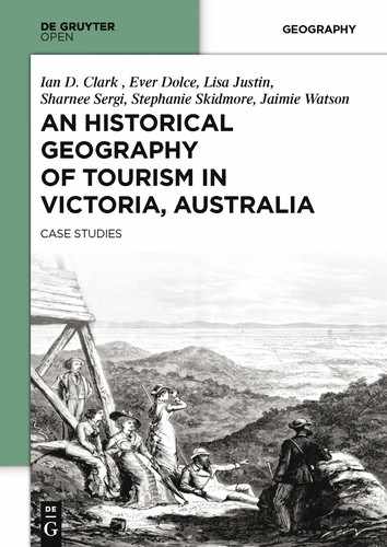
The Illustrated Australian News (21/2/1877) gives an interesting account of the Werribee Plains which it described as ‘an interminable succession of sand, pasture and sheep; sheep, sand and pasture. About midway through this setting of sun parched, arid wilderness, rises a jewel of heaped up rock and dense vegetation, the group of ten or twelve hills known as the You Yangs. To artistic wanderers they are a perfect epitome of grand effect’ (see Fig.9.1).
In January 1879 the Illustrated Australian News published another article on the You Yangs and recommended it as a suitable location for lovers of wild nature and those who enjoy a good scramble. The article also refers to the habit of visitors to graffiti the rocks by scratching their initials or carving their names (see Fig.9.2):
To all lovers of truly wild nature and enjoyers of a good scramble, we recommend this route to enjoy a holiday. The You Yangs are a group of thickly-wooded volcanic hills between Melbourne and Geelong, about, two miles from Little River station, from which township an excellent road runs into the town common at their foot, and such a town common as for picturesque beauty and singularity has not its equal in the colony, perhaps not in the world. Huge basalt rocks, in every conceivable form that volcanic upheaval, ocean waves, rain, sun and frost can produce, are there in profusion. Some steep hills, with sides serrated with stone, and glittering with varied foliage; others glowing with heaths, and having broad tracks of close springy grass extending to the very summit. It is like a bit of pre-Adamite world, and in its every peculiarity the absolute opposite of the entire country around it. The highest peak of this group is Station Peak; its height is about 1600 feet, and it is crowned by the wooden erection used by the geodetic survey. It is a favorite resort of picnic parties from Geelong, and, occasionally, Melbourne. It is profusely scored with initials of its many visitors, and with the magnificent prospects it presents on the landward side of its outlying hills, flanked by extensive plains, and bounded on the far-off horizon by the dim line of the Anakies, and on the seaward by the Werribee Plains, the Bay and the opposite coast. It is rather puzzling what queer mental peculiarity possesses Englishmen who take the trouble to face so formidable an upward scramble, and causes them to spend time and break pen- knives in carving their names in hard wood, almost hardened into stone by exposure to all sorts of weather. The only wonder is that the easy distance from Melbourne of the You Yangs has not made them a more, popular resort for pleasure-seekers and sportsmen (Illustrated Australian News, 22/1/1879).
With the formation of the Field Naturalists Club of Victoria and Geelong Field Naturalists Club in 1880 regular excursions to the You Yangs were organized for their members to explore the granite ranges. Several reports of excursions in the 1880s were published in The Victorian Naturalist and The Southern Science Record. The first account presented a dismal picture of the You Yangs ‘which are simply piles of immense boulders heaped one on top of another, with scant vegetation and a somewhat desolate appearance’. The writer warned that ‘Water here is scarce, and tourists should provide themselves in this regard before starting. To the sportsman, this district should be a perfect Elysium, as rabbits swarm from every rock and hill; but to the collector of plants and insects, it will, I am afraid, prove but a very indifferent field’ (Pescott, 1995: 107). Pescott notes that despite these unflattering comments members of the Field Naturalists returned to the You Yangs; visits took place in 1883, 1886, 1908, 1916, 1917, 1933, 1936, and 1960, for example.
The increase in timber extraction from the You Yangs in 1885 culminated in an outcry from the residents of the surrounding area; who believed that due to excessive extraction, less rainfall was the consequence (Waarden, 1986: 6). By 1896, some 480,000 trees had been planted in over 300 ha. The grazing commons were abolished in 1904 and over 1,400 ha declared state forest.
A DAY ON THE YOU YANGS.
To those whose holidays are limited to occasional days, or even less, and who have not as yet made the trip, a few hours on the You Yangs should come as a welcome break to the usual bay excursion, or suburban seaside township, with its monotonous drift of sand, and low uninteresting cliffs. Scenery of whatever kind has certain charms, which may, and does appeal to lovers of nature, but the craving for what is greatest and best can only be satisfied by communion with nature amid the grandeur of her mountains. This is the experience of all who have set out to find the best the world has to give to her of times unworthy sons and daughters.
Again comes the call of the hills, and again we must respond. We would like to once more climb the highest peaks of our Australian Alps, or even wander amid the ranges of the Great Divide. Unfortunately we must leave these for some future time, but we can renew our friendship with the You Yangs, and so while the holiday trains are crowded with happy people speeding away to distant scenes, we content ourselves with a humble day-return to Little River. Never mind, we are going to a mistress, whose charms never fade, who will continue to unfold fresh and yet fresher beauties.
Just before the train enters Little River station, it crosses a road. This road takes us in a straight line to within half a mile of the foot of Wurdi-Youang or Station Peak, the highest of the Anakies or You Yangs. A gentle walk of three-quarters of an hour having brought us to an iron gate, and the end of the road, a track will be noticed branching off to the left toward the foot of the main ridge. We follow this track, keeping straight toward the lower end of the ridge until we come to a rabbit proof fence (the You Yangs are infested with rabbits). Crossing this we see a broad plough track (cut for a fire break) over a clear part of the ridge. Two or three minutes along this track, and we are on the centre of the ridge, and can now begin the ascent proper. The western face of the ridge is more rock strewn and rougher than the eastern, so in skirting boulders and obstructions, it is better to keep to the right, always getting back to the centre as soon as convenient. Ten minutes or so and we clamber the boulders forming the summit. This is the easiest path, and the one generally followed, and can be accomplished by ladies and children without much undue effort. The ascent can be made from any point by the average rock climber, though there are parts where the help of one’s climbing boots and baton will be appreciated. Although the ascent has been easy, there is nothing little or ordinary about the view. Of its kind, the view from the top of Station Peak is unsurpassed in Australia; Isolated and abrupt, in the midst of a vast plain, a panorama lies at our feet that takes a more powerful pen than ours to adequately describe. In fact few, very few, have possessed the gift to give to others their own impressions of scenery, and this must of necessity be so, as nature speaks and appeals to us in way that are really beyond language. From the Queen City of the South away on our left, to the admirably situated city of Geelong on the right, one level spread of cultivated plain gives us some idea as to the extent crop growing is carried on even at our doors. Seemingly almost at our feet, though nine or ten miles away, the sea sparkles and glistens, looking about as wide as a river estuary, but it is twelve miles across it to the undulating cliffs of Portarlington. We are lucky in being favored with fine clear weather to-day. We can pick out the white sails of small craft pleasantly sailing along, and the “Courier” steaming to Geelong looms up quite large. The country to the north and west is different, in that very little cultivation can be seen. We can see, however, clear up to the Great Divide forty miles away, but except for a few miles in front, the country has the appearance of being virgin bush. As before noted, the western face of the mount is the wildest, almost approaching to desolation. The country to the west too seems wild and uninhabited, yet we confess that we like this side the best. Perhaps it is the setting sun “hallowing with golden rays.” We catch ourselves thinking: Will the world be better and happier when the western plain shall have become as the eastern. Let us be charitable, and hope so. At the foot of the peak to the south west, a large rock will be noticed in the shape of an inverted basin. The rock covers about an acre and a half of ground, and is estimated to measure 4,000,000 cubic ft. It is probably the largest detached rock in Victoria. On the top-the part that corresponds with the rim of the basin-amidst the dust of ages, several trees are growing quite contentedly. It must be remembered that the cracks and crevasses of rocks hold water for a long time. This accounts for the trees on the mount being of healthy and luxuriant growth. It may also account for the fact that, on our last visit, although we encountered no grasshoppers on the plains, the hills were swarming with them. Another curious thing we found: lizards like cheese. While eating our humble lunch on the summit, a good sized-black-rock-lizard came along, and squatted in front. Probably he makes this rock his home, and is used to strangers. Anyhow he looked friendly, so we threw him a piece of bread. He greedily licked off the butter, and made a valiant attempt at the crust, lizards jaws are not made for chewing hard tack, and he was distinctly beaten. In fun, we threw him a piece of cheese, and I never want to see anything more comical than a lizard wolfing cheese (wolfing is just the word). My friend had a good feed. I hope he did not suffer unduly from indigestion.
It is not likely that the You Yangs have ever been of great height-the present height is 1,154 feet above sea level; the mount proper is 1,003 ft. high at most not more than 2,560ft., as proof of this, one can step off the plain on to the mount proper at almost any part, and more particularly opposite the highest point, facing south east, where the side is most precipitous (This is also the most-picturesque). Had the range been of any considerable height in former times the disintegration would have made the approaches more gradual. The surrounding country is basaltic. The range is of gneiss formation. I have not been able to find any natural signs of gneiss more than 500 yards from the base on the eastern side (the most precipitous). The presence of feldspar favors the theory that the range owes its formation to volcanic agency. Though why in so many instances isolated mountains should differ in basic formation from their immediate surroundings is yet unexplained, and personally, much as I would like, I am quite unable to give a feasible explanation to this curious phenomena. Few people would suppose the You Yangs as high as Mount Macedon, yet the mounts proper are within a few feet (15ft. to be exact). The country rises for miles, until the base of Macedon is reached, which gives the mount its majestic and massive appearance. Just a few words in conclusion. The best time to pay a visit is in the spring. One gets greater contrasts, and a good field glass should be taken. During spells of hot weather, haze will usually obstruct the view, should the wind be from the north. Rocks get very hot, and give out great heat. A day-or-two after rain is a good time to make an ascent. Remember that the view of a mountain may be as satisfying and good as the view from it. If you have an eye for the beautiful, with ourselves, not the least of your pleasure will be the contemplation of Station Peak from the near plain, and may be the memory that wilt linger longest of your day on the You Yangs. J.T.C. (North Melbourne Courier and West Melbourne Advertiser, 4/2/1910).
In September 1916, some members of the Field Naturalists Club of Victoria made an excursion to the You Yangs. The results were published in The Victorian Naturalist (1916: 89):
A report of the excursion to the You Yangs on Saturday, 16th September, was made by one of the leaders, Mr. R. A. Keble, who stated that a number of members and friends took part in the outing. The party left town by the 6.30 a.m. train, reaching Little River at 7.40, and immediately set out for Station Peak, the crest of which was attained about mid-day. After spending some time viewing and dealing with the physiography of the surrounding country, a leisurely descent was made, and a northerly course maintained till a small spring was reached. In the immediate vicinity of this spring a number of skinning flakes, scrapers, &c., relics of the aboriginals, were picked up. The party left the reservation about 3 p.m., returning to town by the 6 p.m. Geelong train.
In 1924 The Argus (25/11/1924) included the following account of the You Yangs in an article on attractions in the Geelong district: ‘North of Geelong are the You Yang Mountains. From Flinders Peak (1,154ft.) one of several lofty points, there is a delightful outlook over many square miles of level country, with the waters of Port Phillip Bay beyond. The You Yangs may be reached by train from Melbourne to Little River, and afterwards by a walk of from five to six miles, or to the foot by motor-car from Geelong or Melbourne’. Another travel account was published in 1950:
Back Tracks For Weekenders By PAT FRANKLYN
WHEN you have had your fill of looking at photographs of rock formations in Central Australia and regretting that you cannot afford either the money or the time to visit them, spend a day in the You Yangs. Doubtless you have seen this range often enough from the beaches on the eastern side of Port Phillip Bay, looming pale blue and jagged across the water. If, on a clear day, you scramble up over the spectacular granitic rock to the top of Flinders Peak, you will see this view in reverse; and, moreover, find Port Phillip Bay spread out, at your feet.
It is of interest that the soil and rock of the You Yangs are some of the oldest in Victoria, and much older geologically than the plain over which you walk from Little River. It is also of interest that Flinders Peak was climbed by some of the first Europeans to visit this part of Victoria. John Murray, sailing from Port Jackson in the Lady Nelson, discovered the entrance to Port Phillip Bay in January, 1802. Ten weeks later Matthew Flinders, in the Investigator, having sailed from England to undertake an exploration of the whole coast of the continent, independently discovered Port Phillip Bay. In the course of a rapid three-day survey of the bay, he landed with a small party on the northern shore of Corio Bay and climbed to the top of the Peak, giving it the name of “Station Peak” (The Argus 29/12/1950).
In 1958, 355 ha were allocated as a scenic reserve and in 1962 an additional 110 ha were given a special purpose reserve status, for the protection of birds. In 1964 the reserve was declared a forest park. Then in 1981 an additional 1515 ha were added, bringing the total size of the park to close to 2,000 ha (Waarden, 1986: 4). Finally, in 1992 the You Yangs Regional Park was gazetted. Its function was ‘to provide opportunities for informal recreation for large numbers of people, and to conserve and protect the natural ecosystems to the extent that this is consistent with the recreational role’ (Pescott, 1995: 79).
In 1969 Aldo Massola published a narrative of a car journey to Victoria’s primary Aboriginal heritage sites. He included the following discussion of the You Yangs:
Historically, too, the You-Yangs are interesting. In 1802, Matthew Flinders climbed the highest peak of this range (which now bears his name) in order to survey Port Phillip. He, and three of his sailors, walked to it from a point in Corio Bay opposite the Peak, a distance of over ten miles, but apart from weariness they only suffered from thirst. In his Journal, Flinders stated that neither on the way up, nor on the return journey, could they find any water. Although he did not know it, water was quite close to him on the Peak. It was in one of those strange water wells hollowed in granite, a cavity developed over the centuries, through the impurities in the hard rock being first softened and then washed away by the action of the elements. The Aborigines no doubt helped nature and accelerated the process by digging into the original fault, thus enlarging and deepening it.
This particular basin is on the lower side of a gently sloping granite boulder, protruding over the surface of the soil. The basin measures forty-nine inches by forty-two inches and is twenty-eight inches deep. Consequently it holds rain water well into the dry season. The rock itself is easily found. It is on the south-west flank of the peak, about 200 yards from the top, and in line between the summit of the Peak and Acre Rock. On Acre Rock, that huge mass of granite said to cover one acre, there are several of these basins, but they are only shallow depressions, and hold little water. However, they must have been used by the Aborigines, since a number of microliths and other small stone implements have been picked up near them. Given time, these shallow depressions would all have become water storage basins.
The Aborigines that roamed over and around the You-Yangs were the Yawangi, one of the many groups of the Wothowurong tribe, whose territory stretched as far as, and beyond, Geelong and Ballarat. Upon the plains, in the early days, there was an abundance of game and edible roots of many kinds and everywhere there was surface water. Under these conditions the Aborigines moved freely, and were able to camp almost anywhere, not being restricted to the water courses or the sea front. Like all natives, however, they preferred to camp on a sandy spot. One such spot is about three and a half miles north-west from Flinder’s Peak, and about one mile north-northwest of Wooloomanata home station. It is a sandy patch, or “blow,” with an area of between four and five acres, situated on the south-west of one of the low undulations so prevalent on these plains. Close to the southern and western sides of the blow there is a stretch of low-lying land which has all the appearances of once having been a swamp. In wet weather two near-by creek beds help to drain the plains and feed what are now dams but could well be the remains of this ancient swamp. These conditions would have been ideal for a camp site, and in fact, the entire surface of the blow is almost covered with chips, flakes, and broken stones of all description, mixed with hundreds of implements, thus proving the site’s suitability.
The Aborigines continued to live in this area even after the occupation of the land by the colonists and the building of Wooloomanata. It is known that Frederick Armytage and his wife, who then owned the station, took a kindly interest in the natives, especially in Billy Leigh, who was “king” of the Yawangi at the time. Billy was baptized and confirmed in the Church of England at Lara, and when he died, in August 1912, the Armytages erected an upright cross on his grave in the Eastern Cemetery (Massola, 1969: 11-13).
According to the Victorian Environmental Assessment Council (VEAC, 2006), the current status of You Yangs as a regional park does not necessarily give it a protected status.
National and state parks provide the highest level of protection for natural features such as flora and fauna and landscapes, and for Aboriginal cultural sites and places and historic sites. Accordingly, harvesting of forest products, grazing by domestic stock, and hunting and firearms are normally not permitted, and national and state parks are exempt (in most circumstances) from exploration and mining under the Mineral Resources Development Act 1990 (VEAC, 2006).
The Department of Sustainability and Environment (DSE, 1996) and the Department of Primary Industries (DPI, 2000) state that the You Yangs sugar gum plantation has been harvested for a variety of commercial timber purposes. However, in an interview, conducted on 30 January 2013 with Mark Whyte, Parks Victoria ranger and team leader, he stated that the plantation is not currently managed for commercial production and harvest of the timber. He stated that management of the timber plantation would normally ensure that the timber is suitable for a variety of uses, such as poles and posts. Because this hasn’t occurred, the most probable use of any such harvest would be for fire wood, thus the likelihood of any future harvest is doubtful.
Commercial quarrying has taken place at the northern border of the park and it is still visible. According to Webb and Marshall (2002), two non-active quarries are within the park’s boundaries and one of these is adjacent to a commercial quarry just outside the park, at the northern end of the Kurrajong plantation. A live firing range is located on the park’s western border and it is possible to hear the rifle bursts, when at the western end of the East-West walking track.
It is clear that the You Yangs would qualify as a National or State Park if not for the commercial activity that has encroached upon what Gunn’s (1994) spatial model would consider to be its ‘inviolate belt’. In order for the fore-mentioned commercial activity to be restricted to the park’s ‘zone of closure’, either the boundaries of the park would need to be reduced or the land upon which these activities are taking place would need to be acquired by the State and incorporated into the park. Unfortunately, as is reported by Waarden (1986), the mining activity in the area is most likely responsible for the destruction of archaeological evidence. Thus, any reduction in the park’s size would most likely further add to evidence destruction.
The earlier designation of the You Yangs as a scenic reserve in 1992, gave the park a status that corresponds to MacCannell’s (1976) ‘framing and elevation phase’. This also fits with Gunn’s (1994) ‘inviolate belt’ zone, in that this reserved section of the site is expressly differentiated from the rest of the plantation. Butler’s (1980) ‘involvement’ stage appears to have preceded the 1958 special purpose reservation, as there is evidence that a tour bus was operating from Little River in 1912.37 The train station at Little River allowed visitors travelling from Geelong and Melbourne to utilize the service of the tour bus.
9.3 Third Phase: Enshrinement 1912–Present
MacCannell (1976) has identified ‘enshrinement’ as the third phase in the evolution of attractions. It is represented by a material increase in visitor numbers to an attraction that signifies the site’s prominence, as a result of enhanced reputation. Due to the distance between the You Yangs from Little River and Lara, it is probable that visitation numbers to the park increased in tandem with the automobile revolution of the 20th Century. The improvement in roads and travel times, made over the last few decades, would also have been a contributing factor to increased tourism.
In 1914 a walking track to Flinders Peak was completed, in order to provide visitors with an easy path to the summit. The Geelong Advertiser’s (26/5/1914) article entitled ‘You Yangs track’ reveals that ‘a gentleman aged 84 years completed the climb from the road terminus over the new track to the summit in 40 minutes without distress’.
In the beginning of the 20th Century, mention of the ‘spring of excellent water’ was again made. The Geelong Advertiser (20/5/1915) article ‘You Yangs Spring’ states that in order to protect the spring ‘against contamination by animals and careless picnickers’ it was fenced off. In a second article, the Geelong Advertiser (29/5/1915) reported that ranger John Blair was responsible for the work of protecting ‘the perennial spring at the You Yangs’ and that this ‘is a decided improvement to the resort’. A third article (Geelong Advertiser, 2/7/1915) revealed that Mr ‘Hennessy, instructor in chemistry at the Gordon Technical College’ had conducted an analysis of the water from the spring ‘with a view to determining the chemical properties of the You Yangsspring, which is largely used by excursionists to this popular resort’.38
This spring was not mentioned by either Waarden (1986) or Webb and Marshall (2002). It would have been a very important feature to the Wathawurrung and its existence should call into question some of the assumptions about habitation within the You Yangs, and the proximity to cultural sites that were previously thought to have no water supply. Having said this, it is worth quoting Mark Urquhart (personal communication, 16/9/2013), ranger in charge at the You Yangs Regional Park:
Unfortunately, none of the staff at the You Yangs are aware of the mentioned spring, including staff that started here in 1972. It is very unlikely that any fencing or remnants of fencing remains, given the catastrophic fires of 1969 and 1985 that impacted the Saddle area and wider park. The western slopes of the Saddle were also cleared and established as sugar gum plantation or utilised for gravel extraction in the early 70s. These works may have removed any established fencing. These works altered the alignment of Pannican Gully (the gully below the Saddle on the western side). I find a natural ‘artesian’ spring to be highly unlikely given the granite monolith base that the You Yangs Range is. The Granite monolith is impermeable to water and has little to no fissures. A natural spring could very well be explained by sub soil gravity fed water flow (non-artesian), which is common on the southern and eastern slopes of the range. This effect remains visible at numerous locations in the park for a number of months following saturating rains. It is caused by water (rain), permeating through the soil, hitting the base rock (granite) and following the rock down slope to a point where the rock is exposed on the side of the hill. These sites are numerous, but have no significant flow or water quality values, and definitely do not have ‘spring or mineral water’ taste.
Pescott (1995: 104) makes reference to the spring when talking about the ‘mysterious cave’. Apparently ‘it is said that in a basin-shaped mass of granite near the summit of the giant peak there is a spring of water’. It is interesting that The Argus (30/12/1857) confidently stated that owing to the water that can be found at the spring ‘there is therefore no occasion to burden a party with the carriage of this necessary element’.
The tourism centre of activity in the You Yangs has shifted over the course of its visitation history. From the late 19th century until sometime in the 20th century the Saddle, to the north of Flinders Peak, was consistently mentioned in visitation reports, as the picnic area. Today, the main entrance, the Big Rock car park and the Flinders Peak car park are the main focal points of the park. Picnic areas with barbeque pits lie in the low areas to the south of Flinders peak.
The Werribee Shire Banner’s (27/7/1925) ‘Lara’ reports that a scheme for the improvement of the You Yangs as a tourist resort had been initiated by interested parties from around the Corio area. A You Yangs Improvement Committee had been established in order to improve the roads within the ‘forest’. The existing graded road to the Saddle and the footpath from the Saddle to the Summit would be improved. Additionally, a rotunda would be erected at the Saddle.
Applying Butler’s (1980) life cycle model, a ‘decline’ in visitation numbers during the first decade of the 21st Century was followed by ‘rejuvenation’, in the form of additional funding that has resulted in visitor numbers returning to their historic 1981/82 high of 250,000 visitor days. The dropping of the park’s entry fee would also have been a contributing factor. Enquiries made to Parks Victoria revealed that visitor counts have not been systematically conducted over the years that the various government agencies have managed the You Yangs. The few counts that were conducted were done using statistical sampling techniques (M. Whyte, personal communication, 30/1/2013). The Land Conservation Council of Victoria (1985, as cited by Waarden, 1986: 58) states that the You Yangs achieved its highest recorded visitations in the year 1981/82. This was again matched in 2012 with 250,000 visitors (Parks Victoria, 2012). However, in the interim years the visitation counts conducted show a dramatic decrease in visitors. In the four years from 1997/98 to 2000/01 visitation counts average 83,069 (Parks Victoria, 2013). Park entry fees were abolished as of 1 July 2010 and this could explain the divergence in visitor counts (Parks Victoria, 2010). Interestingly, it is noted that an increase from 5,000 to 100,000 mountain bike riders occurred in 2012 (Parks Victoria). This would suggest a demographic change in demand for the park, possibly as a result of funding being provided for extensive mountain bike tracks. Whyte (personal communication, 30/1/2013) stated that current counts are conducted at various track locations and that the results of these counts were used to deliver the 2012 count, of 250,000 visitor days.
Because the You Yangs is not a State or National Park, Parks Victoria is not obligated to produce management plans (VEAC, 2006). Such plans generally provide insight into management’s decision making, based upon conditions prevalent at the time of the report, and can include details about park usage and visitor counts.
9.4 Fourth Phase: Duplication 1847–Present
MacCannell’s (1976) fourth phase in the development of attractions is that of ‘duplication’, when copies of the nucleus of the attraction, in this case the ranges, are made available through media such as paintings, photographs, and postcards. As early as 1847, the You Yangs began to be subject to ‘duplication’ as a consequence of its significance to the settlers of Victoria. One of the first paintings featuring the You Yangs is by John Skinner Prout, painted in 1847, and although this painting focuses on Geelong, the You Yangs are clearly visible in the background. Robert Hoddle’s 1847 watercolour ‘Station Peak from St Kilda, 1847’ is another painting from this period that presents a view of the You Yangs in the distance. ‘View of Station Peak’ by George Alexander Gilbert, was painted in 1856, brings the You Yangs into focus and is probably the first art work to do so (Fig.9.3). Emma von Stieglitz in 1854 painted various views of the You Yangs, including Station Peak, and a deserted Aboriginal mia-mia at Villamanatta (see Pescott, 1995: 20). In 1857, Horace Burkitt, a postal clerk stationed temporarily at Geelong, painted two small water-colours of the You Yangs (see von Stieglitz, 1964). Fred Williams, a prolific Victorian artist, also created a number of works depicting the You Yangs in the 1960s. The You Yangs have also been photographed by many noted photographers, including the geologist Richard Daintree in 1861; in 1866 Eugen de Balk included a photograph in his Album of Geelong Views; Fred Kruger photographed the ranges in the 1880s. Samuel Calvert’s (1885) ‘Scene in the You Yangs’ is interesting as it depicts cattle being present after the 1866 act of turning the park into a timber reserve (Fig.9.4). This is corroborated by The Bacchus Marsh Express (6/3/1869) article mentioning depasturing restrictions at that time.
The above mentioned artworks attest to the use of the You Yangs by artists over the decades since colonisation. However, it is the silhouette of the entire park that is the main focus of such art works, due to their recognisability. The nucleus, which includes Flinders Peak, is a contributing part to the park’s recognisable vista. This differs from the example of Lal Lal Falls where the nucleus, being the falls themselves, was the sole subject of duplication. MacCannell’s (1976) ‘duplication’ phase is realised as the park has evidently been used as a subject of numerous representations since its ‘discovery’ by Europeans.
In a satirically posed and highly negative review of You Yang’s Summit (Odgers,1857) The Ballarat Star (27/11/1858) goes to some length to mock the work, which they erroneously attribute to Stitt Jenkins, a bricklayer by trade and a leading temperance advocate and later prominent figure in civic affairs. This work is the first detailed writing that has the You Yangs as its backdrop, although it deals primarily with the characters and their drama while hiking. The Star’s main objection to the work is that it focuses on the folly of these shallow people when so much could have been written about the hardships of the people of the area surrounding the You Yangs.
9.5 Fifth Phase: Social Reproduction
For MacCannell, the final stage of sight sacralization is social reproduction which ‘occurs when groups, cities, and regions begin to name themselves after famous attractions’. In the case of the You Yangs, social reproduction has occurred in the naming of the You Yangs Hotel. Other local businesses include You Yangs Medical Clinic and You Yangs Yoga Centre, both in Lara. The Melbourne steam ship company purchased the steamer Kieff in 1863 from London and renamed it the You Yangs; subsequently bringing it to Melbourne for service between Melbourne, Sydney, and Newcastle NSW; it was wrecked on 12 June 1890 on a reef near Pelorous Island, South Australia.
9.6 Indigenous Values at the You Yangs
Unfortunately, the Indigenous significance of the You Yangs has not been adequately communicated to the wider community. Nora van Waarden (1986) identified 45 sites within the park that facilitated habitation and/or ritual, but noted that due to the passage of time, site disturbance and the fragmenting of Wathawurrung cultural knowledge, it is unlikely that we shall ever be able to answer questions that arise as to the utility, and significance of the park. The recent survey by Webb and Marshall (2002) increased the count of identified sites by 289.
The high elevations of the peaks offered the Yawangi an obvious advantage in times of conflict; this being the ability to survey the land in order to spot an approaching enemy. The Werribee River to the NE was a boundary between three tribes, the Wathawurrung, Woiwurrung and the Boonwurrung (Clark, 1990). As signalling was an observed way in which Indigenous people would communicate an approaching danger (see Learmonth, 1853; as reported by Bride, 1898: 40), it is likely that the three Wathawurrung clans of the area gained some strategic advantage from the panoramic opportunities offered by the You Yangs.
Waarden’s (1986) archaeological report details the presence of the Yawangi baluk over much of the park’s area. The You Yangs has four rock well sites that were used by the Yawangi. At each rock well site, evidence has been found to show that habitation occurred there. Situated in an unpublished location, north of the You Yangs and close to the Little River, is an arrangement of about 100 stones that have been given the name Wurdi Youang. Norris (2010) states that this stone arrangement is a significant example of Indigenous knowledge of astronomy prior to European contact. He details how the arrangement ‘indicates the setting position of the sun at the solstices and at the Equinox’. In an interview conducted on 30 January 2013, Wathawurrung elder David Tournier, Cultural Heritage Education Language Officer Wathaurong Aboriginal Co-operative, at Geelong, explained that the three large stones at the western end of the arrangement align with the Anakie Hills to measure the movement of the sun.
Tournier (personal communication, 30/1/2013) said that there used to be a representation of Bunjil, with its origin in prehistory, located at the You Yangs. He states that the representation had been situated close to the current Flinders Peak car park, before being ‘destroyed’. A photograph, provided by Tournier, depicts a very large stone in a shape that resembles a beak, with the caption ‘this rock was remove[sic] from the you-yangs [a] long time ago (this rock is Bun Jil’s beak)’. According to Tournier, a large cover stone once existed and covered the Big Rock’s main water hole. This stone’s function was to ensure that clean water was available all year and acted to reduce evaporation, and promote condensation. He spoke about an event that he had witnessed when he was 8 years old. He states that at the time, a number of older boys pushed the cover stone off the water hole and over the side of the big rock, where it shattered on the ground below. He also stated that the Big Rock was ‘traditionally’ used as a ‘school’ for the education of young Wathawurrung people.
As part of the Victorian Aboriginal Heritage Act of 2006 the Wathaurung Aboriginal Corporation, based in Ballarat, is the registered Aboriginal party responsible for decision making in matters of Indigenous cultural sensitivity at the You Yangs (DPCD, 2012). Prior to the 2006 Act, the Wathaurung Aboriginal Cooperative, based in Geelong, was the responsible party.
9.7 Tourism at the You Yangs
The facilities at the You Yangs are scattered around the park, with rest rooms located at the park’s entrance, the Big Rock car park and the Flinders Peak car park. These are modern facilities that provide running water, toilet paper and appear to be regularly serviced. Barbeque and fire places are situated throughout the lower elevations, and at both of the fore mentioned car parks. Orienteering, mountain bike riding, bushwalking, abseiling and horse riding are activities that can be experienced while at the park. Numerous information boards are evident at various locations. The content of these boards provide visitors with basic information regarding the geology, history, flora and fauna, activities, and an Indigenous perspective. However, this perspective is focused on the last known living Yawangi person, King Billy Leigh, and does not elaborate upon the Yawangi baluk clan or Wathawurrung tribe in sufficient detail.
At the beginning of the Flinders Peak walking track and the East-West walking track, there are two smaller information boards that narrate the experiences of Matthew Flinders and William Buckley. It is unfortunate that a greater representation of Yawangi and Wathawurrung culture has not been made available to visitors of the park. It is reported that the initial European contact with the Yawangi included a friendship between the squatter Robert William von Stieglitz and the then Yawangi clan-head Murrydenneek (Clark, 1998). The Museum of Victoria is in possession of a large number of Yawangi artefacts in its Sutton collection, sourced from an area near the Wooloomanata Station (Waarden, 1986: 17). Perhaps at some point, part of this collection will be on display at the park, thus shining some light on the Yawangi people’s presence at the You Yangs.
As part of the Commonwealth Games hosted by Melbourne in 2006, Andrew Rogers was commissioned to create an artistic representation of the Kulin creator Bunjil. This was done through the medium of a geoglyph. This geoglyph is visible from the high elevations of the You Yangs East-West walking track and from Flinders Peak. Visitors are able to walk to and amongst the stones that make up this artwork.
Once renowned as a picnic destination, today the You Yangs attracts a very different type of tourist. A possible reason for the shift in focus from the Saddle to the current areas of high use could be explained by the change in use of the park and the change in demand from picnicking to other forms of recreation. Bike tracks crisscross large tracts of the park and many of the large rock outcrops have metal ring attachments to assist abseilers.
9.8 Management Issues
According to Pescott (1995), the Field Naturalist Club of Victoria provided its first report on the You Yangs in 1881; however, they paint ‘a rather dismal picture of the You Yangs’.
Since the introduction of boneseed into the park in the 1940s, as a means to reduce erosion, this plant has posed a major challenge for the conservation and viability of native flora and fauna within the park (Roberts, 2008). Today a number of stakeholders actively participate in the eradication of this aggressive plant. This eradication program is supported by schools, volunteers and the park management. Roberts has detailed the various methods employed to eliminate this invasive plant and an active burn back program is underway; as this has been proven to be the most effective means of controlling boneseed.
As a result of three flood events, the park closed in February 2011. State government funding of $1.5 Million was given to commence recovery works and in August 2011 the park was reopened to the public (Geelong Advertiser, 8/8/2011). The main reason for the large budget was that the floods had uncovered asbestos culverts (pipes) at 90 locations around the park. Subsequently, 80 tons of asbestos were removed and 100 pipes replaced (Geelong Advertiser, 1/3/2011; Pearson, 2011). The park has also had a number of severe fire events. The most dramatic occurred on 8/1/1969 and burnt the entire park, and destroyed much of Lara and resulted in the deaths of 17 motorists on the Geelong to Melbourne freeway (DSE, 2012).
Waarden (1986) states that because of abundant vegetation cover and inaccessibility, many of the rock-wells and scatter sites are not in danger of being discovered or damaged by visitor use. However, a number of scatter sites are located in areas that have a heavy visitor presence and as such require continued monitoring. A number of recommendations that were made by Waarden (1986) have not been implemented. These recommendations centre on providing educational material and information to the public and in particular school groups. Waarden emphasised providing material that could be handled; as well as display cases that could house local artefacts. At the time of the survey (1986) they were stored at the Museum of Victoria. The current information room, located at the park’s office, does have information about Australian Aboriginal culture; however, this is largely focused on generic information that is not specifically focused on the Wathawurrung tribe.
A second archaeological survey was conducted in 2002 by TerraCulture Pty Ltd, on behalf of Parks Victoria (Webb & Marshall 2002). The aim of this second survey had two stages. Stage 1 was to document the archaeological evidence in the areas of the park that Waarden (1986) had not included in her 1986 survey. This included the lowland areas of the southeast and western part of the park, and the uplands to the northeast (Webb & Marshall, 2002). Stage 2 was to provide Parks Victoria with a risk assessment analysis and recommendations for management of the park. These recommendations were generally designed to provide rangers with a protocol to follow in the event of direct contact with archaeological material.
9.9 Conclusion
The You Yangs have been shown to be a different entity to the sites that are the subject of the other case studies in this volume. It is not a single waterfall or a single mountain but rather a range of granitic hills, of which approximately only a third have been formed into the You Yangs Regional Park. The largest peak in the You Yangs is one of the earliest sites in Victoria that were visited by a European – in this case Matthew Flinders in 1802.
In 1835 part of the You Yangs was retained as a Common and used for cattle grazing and timber cutting. This became a Crown Lands Timber Reserve of about 1,000 ha in 1866. In 1875 the reserve was increased to its present size of 2,000 ha. In 1958 some 355 ha were declared a scenic reserve, and in 1962 an additional 110 ha was given special purpose reserve status for the protection of birds. In 1964 the reserve became a state forest. In 1981 some 1,515 ha were added bringing the park to 2,000 ha. In 1992, the reserve became the You Yangs Regional Park –to provide opportunities for recreation and to protect and conserve natural ecosystems to the extent that this was consistent with its recreational role.
It has been a site for botanical research since 1853 when the government botanist von Mueller conducted field surveys there, and with the formation of the Field Naturalists Club of Victoria in 1880, regular excursions have been conducted to the reserve. In 1853, the You Yangs was not the subject of much visitation, and the Geelong Advertiser speculated that perhaps as few as 50 people had stood on its highest peak. The advent of the railway from Geelong to Little River saw the You Yangs become a favourite destination for day excursionists from Melbourne and Geelong.
The You Yangs has been and remains an important historical attraction, especially for people who are interested in the early colonial period when Europeans first explored and settled in Victoria. There is a wide range of diverse activities available at the park. The recent surge in mountain bike rider participation attests to management’s successful efforts in rejuvenating visitor interest. The viewpoints of Butler (1980), Gunn (1994) and MacCannell (1976), have been used to show the change in use and visitation at the You Yangs. Today the You Yangs offer visitors a variety of experiences, through the provision of modern amenities and infrastructure. The changing demographic demand for the park and the continued involvement of the two Wathawurrung organisations, allows for an expanded offering of Wathawurrung culture, and history. Thanks to the archaeological work carried out by Waarden (1986) and Webb and Marshall (2002), evidence is available to show the Indigenous connection to the You Yangs. Should certain recommendations of Waarden (1986) eventually materialise, the public could have access to a much richer experience than is currently offered at the park. The Wathaurong Aboriginal Cooperative could perhaps take advantage of the infrastructure already available, such as the Duck Ponds school building; in order to conduct educational and welcome to country interactions, with schools and other groups.
References
Balk, E. de (1866). Geelong Album photographed by E. De Balk. Geelong: de Balk.
Billot, C.P. (1979). John Batman: The Story of John Batman and the Founding of Melbourne. South Yarra: Hyland House.
Blake, L.B.J. (1977). Place Names of Victoria. Adelaide: Rigby Ltd.
Bride, T.F. (Ed.). (1898). Letters from Victorian pioneers: being a series of papers on the early occupation of the colony, the aborigines, etc. Melbourne: RS Brain.
Butler, R.W. (1980). The concept of a tourist area cycle of evolution: implications for management of resources. The Canadian Geographer, XXIV(1):5-12.
Boyce, J. (2011). 1835: The Founding of Melbourne & the Conquest of Australia. Collingwood: Black Inc.
Clark, I.D. (1990). Aboriginal languages and clans: an historical atlas of western and central Victoria, 1800-1900. Melbourne: Department of Geography and Environmental Science, Monash University.
Clark, I.D. (1995). Scars in the landscape: A register of massacre sites in western Victoria, 1803-1859. Canberra: Australian Institute of Aboriginal and Torres Strait Islander Studies.
Clark, I.D. (1998). Understanding the Enemy: Ngammadjidj Or Foreign Invader?: Aboriginal Perception of Europeans in Nineteenth Century Western Victoria. Clayton: Faculty of Business and Economics, Monash University.
Clark, I.D. (2002). The ebb and flow of tourism at Lal Lal Falls, Victoria: a tourism history of a sacred Aboriginal site. Australian Aboriginal Studies, (2), 45-53.
Clark, I.D. & Heydon, T.G. (2002). Database of Aboriginal Placenames of Victoria. Melbourne: Victorian Aboriginal Corporation for Languages.
Clarke, M. (1980). Big Clarke. Carlton: Queensberry Hill Press.
Department of Planning and Community Development (DPCD) (2008). Aboriginal Flaked Stone tools. Department of Planning and Community Development. Victorian Government. Retrieved January 25, 2013 from http://www.dpcd.vic.gov.au/__data/assets/pdf_file/0011/35876/AA_04_StoneTools_12.06.08.pdf
Department of Planning and Community Development (DPCD) (2012).Registered Aboriginal Parties. Department of Planning and Community Development. Victorian Government. Retrieved February 2, 2013 from http://www.dpcd.vic.gov.au/indigenous/aboriginal-heritage-council/registered-aboriginal-parties
Department of Primary Industries (DPI) (2000). Sugar gum for farm forestry. Department of Primary Industries. Retrieved January 29, 2013 from http://www.dpi.vic.gov.au/forestry/private-landforestry/individual-species/sugar-gum-for-farm-forestry
Department of Sustainability and Environment (DSE) (1996). Midlands Forest Management Plan – Chp 4 Timer production. Department of Sustainability and Environment. Retrieved January 29, 2013 from http://www.dse.vic.gov.au/forests/publications/plans/forest-management-plans/midlands/timber-production
Department of Sustainability and Environment (DSE) (2012). Bushfire history–Major bushfires in Victoria. Department of Sustainability and Environment. Retrieved January 30, 2013 from http://www.dse.vic.gov.au/fire-and-other-emergencies/major-bushfires-in-victoria
Flinders, M. (1814). A voyage to terra Australis, 2 Vols. London: G. and W. Nicol.
Gunn, C.A. (1994). Tourism Planning: Basics, Concepts and Cases. Washington: Taylor and Francis.
Harcourt, R. (2001). Southern Invasion-Northern Conquest: Story of the Founding of Melbourne. Blackburn South: Golden Point Press.
Labilliere, F.P. (1878). Early history of the colony of Victoria: from its discovery to its establishment as a self-governing province of the British Empire, 2 Vols. London: Sampson Low, Marston, Searle & Rivington.
MacCannell, D. (1976). The tourist: A new theory of the leisure class. New York: Schoken.
McCrae, H. (Ed.) (1934). Georgiana’s journal: Melbourne a hundred years ago. Sydney: Angus & Robertson Ltd.
Massola, A. (1968) Aboriginal Place Names of South-east Australia and their meanings. Melbourne: Lansdowne Press.
Massola, A. (1969). Journey to Aboriginal Victoria. Adelaide: Rigby Ltd.
Illustrated Australian News 21/2/1877; 22/1/1879
Norris, R. (2010). Wurdi Youang, Australia – case study 4.3. ICOMOS-IAU Thematic Study as part of the UNESCO World Heritage Convention 2010. Retrieved January 29, 2013 from http://www2.astronomicalheritage.org/images/astronomicalheritage.org/thematic-study/ch04cs3.pdf
North Melbourne Courier and West Melbourne Advertiser 4/2/1910
Odgers, L.L. (1857). You-Yang’s summit: a narrative of the proceedings of a pic-nic party: their conversation: with an account of the brilliant scenery, magnificent landscapes, and unparalleled grandeur of the surrounding country in view from the summit of the mount. Thomas Brown, Geelong.
Parks Victoria (2010). Parks Victoria annual report 2009/10. Parks Victoria. Retrieved January 31, 2013 from http://parkweb.vic.gov.au/__data/assets/pdf_file/0010/305011/pvar_200910.pdf
Parks Victoria (2012). New facilities boost the You Yangs experience. Parks Victoria. Retrieved January 15, 2012 from http://parkweb.vic.gov.au/about-us/news/new-facilities-boost-the-youyangs-experience
Parks Victoria (2013). ‘Visitor number monitor – 1997 to 2001’. Unpublished report. Parks Victoria.
Pearson, E. (2011). ‘Lara’s You Yangs ‘about to reopen’. Surf Coast Independent (24/6/2011). Retrieved February 2, 2013 from http://www.starnewsgroup.com.au/indy/torquay/232/story/135790.html
Pescott, T. (1995). The You Yangs Range. Belmont: Yaugher Print.
Roberts, D. (2008). A history of boneseed control in the You Yangs Regional Park, Victoria. Plant Protection Quarterly, 23(1):51.
Scott, E. (Ed.). (1966). Australian Discovery by Land. Johnson Reprint Corporation.
Scott, E. (2001). The Life of Matthew Flinders. Melbourne: Angus & Robertson.
Smyth, R.B. (1878). The Aborigines of Victoria, 2 vols. Melbourne: Victorian Government Printer.
Stieglitz, K.R (ed.) (1964) Emma von Stieglitz: her Port Phillip and Victorian Album. Hobart: Fullers Bookshop.
The Argus 22/11/1856; 28/10/1857; 30/12/1857; 7/11/1867; 26/10/1868; 18/6/1890; 25/11/1924; 23/10/1936; 19/12/1950
The Bacchus Marsh Express 6/3/1869; 18/4/1896
The Ballarat Star 27/11/1858; 4/9/1869
The Geelong Advertiser 1/12/1851; 26/5/1914; 20/5/1915; 29/5/1915; 2/7/1915; 1/3/2011; 8/8/2011.
The Geelong Advertiser and Intelligencer 17/12/1853
The Maitland Mercury & Hunter River General Advertiser 30/10/1856; 27/7/1867
Todd, W. Journal June-November 1835, Typescript copy 16 pp, State Library of Victoria, Ms. 11355.
Victorian Environmental Assessment Council (2006). River Red Gum Forests Investigation. VEAC.
Victorian Naturalist (1916) Report of an excursion to the You Yangs … Victorian Naturalist, Vol. 23, No. 395, p. 89.
Waarden, N. V. (1986). Archaeological Survey of the You Yangs, Victoria, An Occasional report (Victoria. Dept. of Health and Community Services. Aboriginal Affairs Division), 80.
Webb, C. & Marshall, B. (2002). An Archaeological Survey: You Yangs regional Park. Unpublished manuscript. Parks Victoria.
Werribee Shire Banner 23/7/1925
Wynd, I. (1981) So Fine a Country: a history of the Shire of Corio. North Geelong: Shire of Corio.
Fig. 9.1: Peak and Valley on the You Yangs (Illustrated Australian News 21/2/1877) wood engraving after a painting by JW Curtis.

Fig. 9.2: Holiday Excursionists on the You Yangs (Illustrated Australian News 22/1/1879). The engraving shows men and women enjoying a picnic and views on the summit of Station Peak which includes a wooden lookout tower.
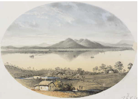
Fig. 9.3: View of Station Peak–(Native You-Yangs)/ taken from the Point Henry Road/ Geelong. / Port Phillip. Gilbert, George Alexander (1856). State Library of Victoria Pictures Collection
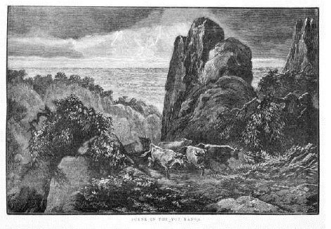
Fig. 9.4: Calvert, Samuel (1885). SCENE IN THE YOU YANGS. Illustrated Australian News 2/9/1885
34 Wathawurrung, Wada Wurrung and Wathaurong are variant spellings for the same Aboriginal language name (Clark, 1990).
35 Station Peak was officially changed to Flinders Peak in 1912, via notification in the Victorian Government Gazette (Scott, 2001); presumably to coincide with celebrations of Flinders’ visit (see below).
36 In 1912 the Victorian government unveiled a bronze plaque set in rock near the summit commemorating Flinders’ visit. In March 1974 a plaque commemorating the bicentenary of his birth was unveiled.
37 The information room at the You Yangs Parks Victoria office has a dated photograph available for viewing.
38 The chemical analysis returned the following result: total solids, 91 grains per gallon; silica, 1.4; iron oxide, .81: calcium sulphate, 3.07; calcium chloride, 6.46; magnesium sulphate, 20.00; magnesium chloride, 8.36; sodium chloride, 50.90.