
The use of geolocation services in enterprise apps is common. One of the most common geolocation requirements is to calculate the distance between two points. This is helpful in planning routes, determining mileage, forecasting delivery schedules, and more.
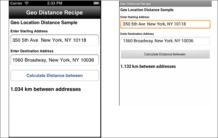
The following recipe demonstrates how to calculate the distance between two addresses. This distance measurement is done using a direct distance, not a routing calculation such as those used for walking or driving. The following screenshots illustrate this recipe running on both an iPhone and an Android device.
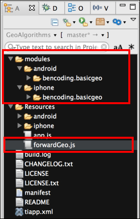
This recipe uses both CommonJS and native modules. These can be downloaded from the source code provided by the book, or individually through the links provided in the See also section at the end of this recipe. Simply copy the forwardGeo.js file into the Resources folder of your project and then copy the modules folder into your project as shown in the following screenshot:
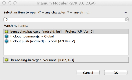
After copying the file and folder mentioned here, you will need to click on your tiapp.xml file in Titanium Studio and add a reference to the bencoding.basicgeo module as shown in the following screenshot:
Once you have added native and CommonJS modules to your project, you next need to create your application namespaces in the app.js file and use require to import the module into your code as the following code snippet demonstrates:
//Create our application namespace
var my = {
  forward : require('forwardGeo')
};The following startAddress and endAddress objects are added to the app namespace. These objects will be used to create the address information and coordinate state for this recipe.
my.startAddress  = {
  needRefresh:true,lat:40.748433, lng:-73.985656,
  address:'350 5th Ave  New York, NY 10118'
};

my.endAddress = {
  needRefresh:false, lat:40.75773, lng:-73.985708,
  address:'1560 Broadway, New York, NY 10036'
};The following code snippet describes how to create the UI shown in this recipe's earlier screenshots:
- The first step is to create the
Ti.UI.Windowto which all visual elements will be attached.var win = Ti.UI.createWindow({ backgroundColor: '#fff', title: 'Geo Distance Recipe', barColor:'#000',fullscreen:false }); - Next the
txtStartAddress Ti.UI.TextFieldis created to allow the user to enter a starting address.var txtStartAddress = Ti.UI.createTextField({ hintText:'enter starting address', value: my.startAddress.address, height:40, left:5, right:5, top:55, borderStyle:Ti.UI.INPUT_BORDERSTYLE_ROUNDED }); win.add(txtStartAddress); - Next the
txtEndAddress Ti.UI.TextFieldis created to allow the user to enter a destination address.var txtEndAddress = Ti.UI.createTextField({ hintText:'enter destination address', value: my.endAddress.address, height:40, left:5, right:5, top:125, borderStyle:Ti.UI.INPUT_BORDERSTYLE_ROUNDED }); win.add(txtEndAddress); - The
findButton Ti.UI.Buttonis then added to theTi.UI.Windowlater in this recipe. This button will be used to perform the distance calculation.var findButton = Ti.UI.createButton({ title:'Calculate Distance between', height:40, left:5, right:5, top:180 }); win.add(findButton);
This recipe uses the geo object to perform distance and address lookup operations.
var geo ={- The
distanceInUnitsuses the Haversine formula and computes the direct distance in kilometers or meters between two sets of coordinates.distanceInUnits: function(lat1, lng1, lat2, lng2){ var rOfEarth = 6371; var dLat = (lat2-lat1)*Math.PI/180; var dLon = (lng2-lng1)*Math.PI/180; var a = Math.sin(dLat/2) * Math.sin(dLat/2) + Math.cos(lat1*Math.PI/180) * Math.cos(lat2*Math.PI/180) * Math.sin(dLon/2) * Math.sin(dLon/2); var c = 2 * Math.asin(Math.sqrt(a)); var distance = rOfEarth * c; - If the distance is less than 1 kilometer, the unit returned is converted to meters.
return { distance: ((distance < 1) ? (distance * 1000) : distance), unit: ((distance < 1) ? 'm' : 'km') }; }, - The
findLocationsmethod is used to obtain the coordinates for the addresses provided.findLocations : function(callback){ - The
onFinishfunction is the callback method provided to theforwardGeofunction. Theeparameter provides the starting and ending address coordinates.function onFinish(e){ if(!e.success){ alert(e.message); return; }The
forwardGeo e.startande.endresults are assigned to themy.startAddressandmy.endAddressproperties. The callback method is then executed, so the distance calculation can be performed.my.startAddress = e.start; my.endAddress = e.end; callback(); }; - The
forwardGeomethod is called to obtain the coordinates for the my.startAddressand my.endAddressobjects. As discussed earlier, the geolocation results are provided to theonFinishcallback method as the following code snippet demonstrates:my.forward.forwardGeo(my.startAddress, my.endAddress,onFinish); } };
When the user presses the findButton and the click event is fired, the recipe will perform a distance calculation between the two addresses entered.
findButton.addEventListener('click',function(e){- The first step in this process is to determine if forward geolocation is supported. The coordinates for each address is required for the distance calculation. A forward geolocation lookup is performed to obtain this information.
if(!my.forward.isSupported()){ alert('Forward Geocoding is not supported'), return; } - The
findDistancemethod is used to make the distance calculation method call and format the provided results.function findDistance(){ - The first step in this section of the recipe is to call the
distanceInUnitsmethod using the latitude and longitude information for each address.var result = geo.distanceInUnits( my.startAddress.lat,my.startAddress.lng, my.endAddress.lat,my.endAddress.lng); - Next the distance calculation results need to be formatted. If the results are in kilometres, the
distancevariable is rounded to the first three decimal places. If it is in meters, the full value will be displayed.if(result.unit=='km'){ result.distance = result.distance.toFixed(3); } distanceLabel.text = result.distance + " " + result.unit + " between addresses"; }; - If either of the address information objects needs to be refreshed, the
geo.findLocationmethod is called. ThefindDistancemethod is provided as the callback method to thefindLocationsfunction so that the distance calculation can be performed after the coordinates are obtained.if(my.startAddress.needRefresh || my.endAddress.needRefresh){ geo.findLocations(findDistance); }else{ - If the address information objects do not need to be refreshed, the
findDistancemethod is called directly to perform the distance calculation.findDistance(); } });