
B |
North American Satellite Geography |
| APPENDIX |
FIGURE
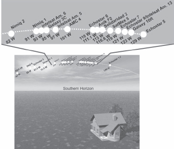
B.1
The American portion of the geostationary orbit extends from about 25 degrees west to 175 degrees west or more (depending on your longitudinal location).
The first digital network in the U.S. was the satellite-based DirecTV using digital to get more channels in the air. Analog direct to home satellite distribution really never got very popular in the U.S. but DirecTV broke the ice for DTH in America. Since DirecTV was introduced too early to be able to use any existing standard a proprietary non-DVB system, Digital Satellite Service (DSS), was developed. DSS is based on similar principles as DVB, yet it is not compatible with DVB.
There are other non-DVB digital standards used for satellite distribution. DigiChiper was developed by General Instruments before the DVB standard was set. This proprietary system is used in several American satellites. Another example is the Japanese ISDB (Integrated Services Digital Broadcasting) system which also exists for terrestrial and cable applications.
The other major U.S. digital satellite TV operator, Dish Network, use the DVB standard. DVB can be used for both 525 and 625 line TV distribution. All systems, DVB, DSS and ISDB can of course also handle HDTV signals.
NORTH AMERICAN SATELLITE SYSTEMS
In North America there are a few domestic U.S. satellite systems, such as Echostar and Galaxy, which compete to carry the content providers. There are also more international systems as Intelsat and PanAmSat. In Canada there are the Anik and Nimiq systems and the Mexican market is dominated by Solidaridad and SatMex.
The downlink frequency bands used are C-Band 3.7–4.2 GHz and Ku-Band 11.7–12.75 GHz. In recent years, the Ka-Bands have also been brought into use: 17.0–20.0 GHz, 20.0–21.0 GHz and 31.8–32.8 GHz. The corresponding uplink frequency bands are 5.9–6.4 GHz, 14.0–14.5 GHz, 27.0–30.0 GHz, 30.0–31.0 GHz and 34.2–34.7 GHz.
The part of the geostationary orbit that is visible from North America is between approximately 25 degrees west and 175 degrees west, depending on where exactly you are (see Figure B.1). The maximum elevation angle is just under 60 degrees in the southernmost part of Texas when receiving from 101 degrees west. The maximum elevation angle in the northern part of the U.S. is at about 34 degrees. For comparison, Europe is much further to the north in relation to North America and the maximum elevation angle in the southernmost parts is at about 45 degrees and in the northernmost parts it is at about 10 degrees.
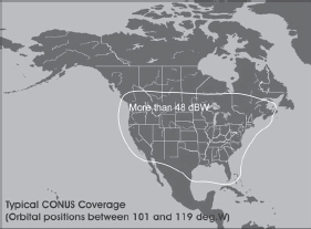
The American content providers Dish Network and DirecTV generally use CONUS coverage (see the example in Figure B.2). The receiving systems are generally 18- by 20-inch proprietary multi-focus antenna systems. The EIRP for the transponders used must be well above 48 dBW. Table B.1 includes some margins that make it possible to reduce the antenna diameter in dry areas.
FIGURE
B.2
Typical CONUS (Continental U.S.) coverage.
SATELLITE RECEIVING SYSTEMS IN THE U.S.
American content providers have to use several orbital locations to reach their viewers. There are two obvious reasons for this. One reason is that the Ku-Band only has a bandwidth of 550 MHz in each orbital slot. Another reason is that there are several time zones within the U.S. continent, and it is appropriate to duplicate some of the channels to hit the various prime time windows.
In Europe it is quite different. There are separate content providers for each language area, all countries are in just one time zone, and there is a bandwidth of 2050 MHz in each orbital slot. For this reason each content provider normally resides in one slot.
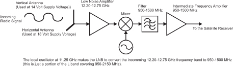
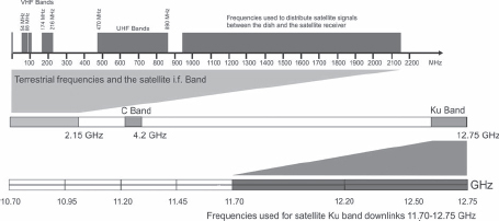
In North America, many satellites operate within the frequency band 12.20 to 12.75 GHz. This is just 500 MHz and can be received by a single-band LNB as is shown in Figure B.3. To receive the signals in the frequency range, 12.20 to 12.75 GHz a local oscillator 11.25 GHz is used to convert the signal. This moves the input frequency band to the range 0.950–1.5 GHz. As a result all signals that may come out of the single-band LNB is in the range of 950–1500 MHz. Universal LNBs like those used in Europe are not required in North America.
Today there are also satellites that operate within the larger frequency range of 11.70 to 12.75 GHz, but still this can be handled by a single-band LNB having a local oscillator at 10.60 GHz (see Figure B.4).
It should also be noted that the North American Ku-Band satellites use linear, horizontal and vertical polarization just like the C-Band satellites do. There are also Ka systems used such as the WildBlue system for Internet distribution via satellite.
FIGURE
B.3
Since the American Ku-Band satellites operate within 550 MHz of bandwidth, single-band LNBs are sufficient in most cases.
FIGURE
B.4
The part of the Ku-Band used in the U.S. is 11.70–12.75 GHz, which can be handled by a single-band LNB.
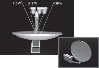
THE THREE LNB MULTI-FOCUS DISH
In the U.S., multi-focus antennas are used by the Dish Network and DirecTV to increase the number of channels for the subscribers. DirecTV, for example, has three orbital positions: 101, 110 and 119 degrees west. By using a three LNB multi-focus antenna, subscribers can receive all of them.
Dish network has even more orbital positions, but one example of using a multi focus dish is the combination of 110, 119 and 129 degrees west shown in Figure B.5.
In Europe, only DiSEqC-switches are used. DiSEqC switches are also used in North America but the content providers also have proprietary receiving systems were the switches are included. DiSEqC is an open standard for those that want to design their own reception systems. If using a DiSEqC-switch you will have to see to that you have a receiver with DiSEqC support.
FIGURE
B.4
In the U.S., both Dish Network and DirecTV use three LNB multi-focus antennas to increase the number of channels for the viewers.
In Chapter 4, Table 4.2 shows that larger antennas were needed when using a secondary focus in a multi-focus dish. However since the antennas used by these content providers are shaped and the loss due to the use of the secondary focus will be quite small, we can still use Table B.1 to estimate the dish diameters required.
COVERAGE AND ANTENNA POINTING MAPS FOR NORTH AMERICA
Chapters 3 and 4 describe the European the North African and the Middle East satellite geography. To understand which satellites can be received, which antenna diameters are needed and how to find the satellites, you need information, just as in conventional geography where you need maps.
Figures B.6 to B.14 will help the North American reader can make full use of the information in Chapters 3 and 4.
The following tables give information about what antenna diameters can be recommended for reception at the different EIRP levels that are indicated in the coverage maps. These figures include some margins for rain attenuation (Ku-Band).
B.1
Approximate antenna diameters at corresponding EIRP levels in Ku-Band
| EIRP (dBW): | meters | feet |
| 41 | 1.9 | 6.2 |
| 42 | 1.7 | 5.5 |
| 43 | 1.5 | 4.9 |
| 44 | 1.3 | 4.4 |
| 45 | 1.2 | 3.9 |
| 46 | 1.1 | 3.5 |
| 47 | 0.95 | 3.1 |
| 48 | 0.85 | 2.8 |
| 49 | 0.75 | 2.5 |
| 50 | 0.67 | 2.2 |
| 51 | 0.60 | 2.0 |
| 52 | 0.53 | 1.7 |
| 53 | 0.47 | 1.5 |
The antenna diameters required in the C-Band is smaller because the noise level (antenna temperature) in the atmosphere is less than Ku-Band and the noise figures of the LNBs are also somewhat better than Ku-Band. However, C-Band satellites are, in general, about 10 dB weaker than Ku-Band satellites.
B.2
Approximate Antenna Diameters in C-Band.
| EIRP (dBW): | meters | feet |
| 28 | 5.8 | 18.9 |
| 29 | 5.1 | 16.9 |
| 30 | 4.6 | 15.0 |
| 31 | 4.1 | 13.4 |
| 32 | 3.6 | 11.9 |
| 33 | 3.2 | 10.7 |
| 34 | 2.9 | 9.5 |
| 35 | 2.6 | 8.4 |
| 36 | 2.3 | 7.5 |
| 37 | 2.1 | 6.7 |
| 38 | 1.8 | 6.0 |
| 39 | 1.6 | 5.3 |
| 40 | 1.4 | 4.8 |
| 41 | 1.3 | 4.2 |
| 42 | 1.15 | 3.8 |
| 43 | 1.12 | 3.7 |
| 44 | 0.91 | 3.0 |
| 45 | 0.81 | 2.7 |
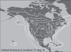
FIGURE
B.6
EIRP curves for Intelsat Americas 5, Ku-Band, at 97 degrees west.
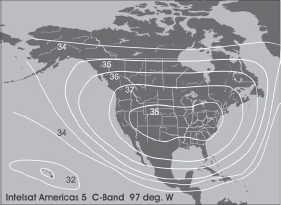
FIGURE
B.7
EIRP curves for Intelsat Americas 5, Ku-Band, at 97 degrees west.
FIGURE
B.8
Intelsat Americas 13 at C-Band 121 degrees west.
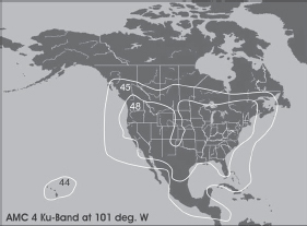
FIGURE
B.9
AMC 4 Ku-Band at 101 degrees west.
FIGURE
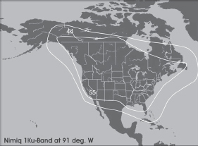
B.10
Canadian satellite Nimiq 1 Ku-Band at 91 degrees west Home of the Canadian content Provider Bell ExpressVu.
FIGURE
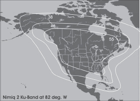
B.11
Canadian satellite Nimiq 2 Ku-Band at 82 degrees west.
FIGURE
B.12
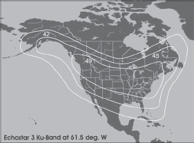
Echostar 3 Ku-Band at 61.5 degrees west. One of Dish Network's satellites.
FIGURE
B.13
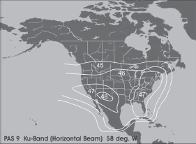
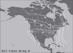
PAS 9 (PanAm Sat) Ku-Band at 58 degrees west.
FIGURE
B.14
PAS 9 (PanAm Sat) C-Band at 58 degrees west.
FINDING THE SATELLITES AND ALIGNING THE ANTENNA
In Chapter 4, the elevation and azimuth angles were defined (Figures 4.3 and 4.5). Figures B.15 through B. include examples of elevation and azimuth maps for important American orbital slots.
Finally, in Figures B.29 and B.30, you find the North American polar mount adjustment angles for motorized antennas. These angles are defined in Figure 4.39.
FIGURE
B.15
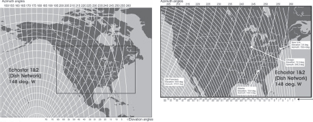
Elevation and azimuth curves for Echostar 1 & 2 at 148 deg. West (orbital slot of Dish Network).
FIGURE
B.16
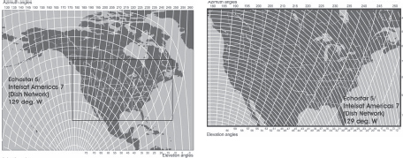
Elevation and azimuth curves for Echostar 5 & Intelsat Americas 7 at 129 deg. West (orbital slot of Dish Network).
FIGURE
B.17
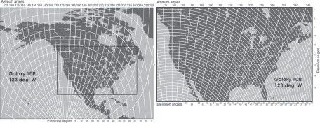
Elevation and azimuth curves for Galaxy 10R at 123 deg. West.
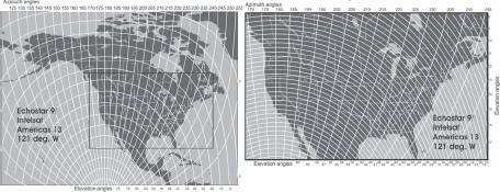
FIGURE
B.18
Elevation and azimuth curves for Echostar 9 at 121 deg. West.
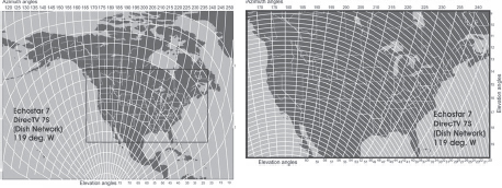
FIGURE
B.19
Elevation and azimuth curves for Echostar 7 & DirecTV 7S at 119 deg. West (orbital slot of Dish Network and DirecTV).
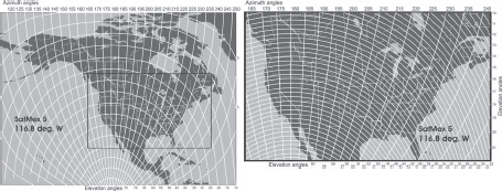
FIGURE
B.20
Elevation and azimuth curves for Satmex 5 at 116.8 deg. West.
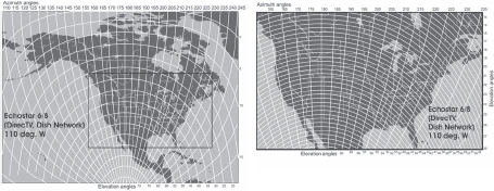
FIGURE
B.21
Elevation and azimuth curves for Echostar 6 & 8 at 110 deg. West (orbital slot of Dish Network and DirecTV).
FIGURE
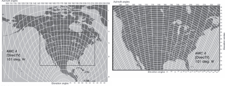
B.22
Elevation and azimuth curves for AMC 4 at 101 deg. West (orbital slot of DirecTV).
FIGURE
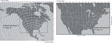
B.23
Elevation and azimuth curves for Intelsat Americas 5 at 97 deg. West.
FIGURE
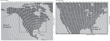
B.24
Elevation and azimuth curves for Nimiq 2 at 82 deg. West.
FIGURE
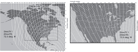
B.25
Elevation and azimuth curves for DirecTV 1 at 72.5 deg. West (orbital slot of DirecTV).
FIGURE
B.26
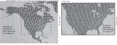
Elevation and azimuth curves for Echostar 3 at 61.5 deg. West (orbital slot of Dish Network).
FIGURE
B.27
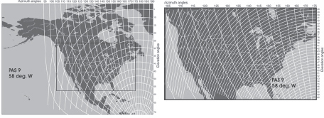
Elevation and azimuth curves for Echostar PAS 9 at 58 deg. West.
FIGURE
B.28
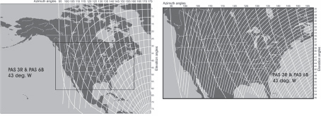
Elevation and azimuth curves for PAS 3R and PAS 6B at 43 deg. West.
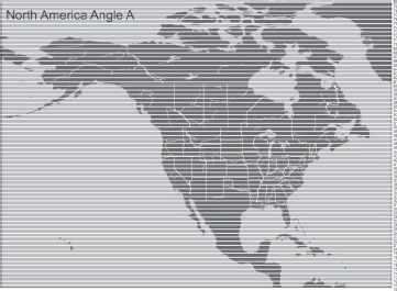
FIGURE
B.29
Angle A in a polar mount motorized antenna (See Figure 4.39 on page 105).
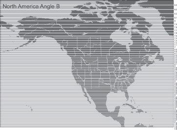
FIGURE
B.30
Angle B in a polar mount motorized antenna (See Figure 4.39 on page 105).