
by Jonathan and Ashley Wegener
Q&A: Exit Strategy NYC
Developer Name: Jonathan and Ashley Wegener
Development Company: JWeg Ventures LLC
Tags: Release Strategy; Outdoing Copycats
URL: http://exitstrategynyc.com/
Exit Strategy NYC (Figure 6-1) is an app built on a big gamble: months of work went into it before any coding began. For developers considering ideas with a lot of sweat equity or real-world overhead—licensing others' content, spending hours on graphic design—the story behind Exit Strategy NYC speaks to one crucial question: is building this app worth it? And if so, how do you scale it into a fully-featured piece of software?
ESNYC began as a simple series of maps that tell New York City subway riders which cars to ride in to make their line-transfers most efficient. (Want to take the L train to the 6 train? Get on the fourth car, and when the doors open, you'll be right in front of the correct set of stairs.) Useful, sure, but also a niche app with limited sales appeal. To gain a following, the brother-sister team Jonathan and Ashley Wegener kept careful focus on their target users, and crafted a careful a press strategy to reach them.
For version 2.0, the pair licensed official New York City subway, bus, and neighborhood maps and turned their app into a comprehensive transit guide for veteran New Yorkers and newbies alike. With a core group of dedicated users ready to sing its praises, ESNYC 2.0 took off to brisk sales and five-star reviews.[9]
It took about two and a half months. We mapped pretty much every day, like a nine to five job. We tried to catch at least one of the rush hours—some days we'd start really early and get the morning rush, and other days we'd catch the evening rush hour. We got more done when the trains ran quicker.
We decided it would be worth it, even if it was just for ourselves and nobody in the world bought our app and it made no money. We sort of made up our minds that this was something that we as New Yorkers wanted.
We also knew we'd get a lot of attention from the media, partially because someone had already done this—not in app form, but in book form in Toronto about five or six years ago—and he got a ton of press for it. We were relatively confident that it was a great idea. I remember the moment I first decided to go forward with it: I was spitting out business ideas that I could make [to a friend], and when I mentioned this one he basically told me, "Dude this is an awesome idea, you have to do it!"
I spent a lot of time doing market research, because that's my background. And I basically ran through a whole bunch of market-sizing questions; the [demographic] numbers, how many we expected to sell. By my estimations, the app should have sold about 30,000 copies if everything went perfectly, and it wasn't too far off from that.
We realized early on that this information is really most useful in your pocket, rather than a web site or some kind of physical book or something. And the project itself, the idea kind of originated when I started recording this information in the notepad feature of the iPhone. I just kept a notepad where the doors were for my own purposes, because I was having trouble figuring it out. So one day I just counted, and I was like, okay, fourth car, third door. So I wrote it down. And I just kept adding stations as I went around the city.
The next logical step to keeping track of something in your phone's notebook is: why isn't this an app? This is the type of thing that hopefully you can turn around and sell for 99 cents to a million people and make a million dollars.
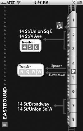
In terms of what Exit Strategy actually is, it's really a very low-tech app; it doesn't use any of the features of the phone, it doesn't use audio, video, visual stuff, it doesn't use accelerometer, it doesn't use the GPS, it doesn't use the Internet, it's entirely offline. Really it's a collection of images, it's just ... the app is nothing more than a delivery vehicle of data and information, and that information is those little pictures of each little spacing diagram. (See Figure 6-2. In version 1.0, not all subway stops were covered. Wegener completed his database for version 2.0.)
When we originally set out to make the app, the original concept was to dynamically draw these cars of the train, and we knew that the number of the cars on the train differed, so you'd either draw eight, nine, ten or eleven, and then dynamically you'd draw the exit to the left of it. The idea was to have a database where we could track for every stop, and have a row in the database for every exit. So like the row would be 42nd street, and then the next column would be the door number, and the car number—something like that.
What we realized when we started sort of making this database was, one, it was going to be incredibly error-prone, trying to enter this information into a database; and two, that we should just use images. Images would be less error-prone, and easier in some ways across platforms. Databases transfer nicely, but images also transfer nicely. (Figure 6-1 shows one such subway image.)
Loading the data as an image makes the app faster and more importantly from our aspect is it lowers the development time and cost. If we're shouldering the work of actually of making the little station images, rather than having to paste the info onto some kind of dynamic drawing algorithm, it makes it a very, very simple app. The interface is sort of just a way to give it a hierarchy and a way to access those pictures. We ended up making that change and hiring a graphic designer to come up with the basic train diagram in Illustrator, and then making hundreds of little images. There are 500 hand-drawn station diagrams in the [1.0 version]. That itself took, well, not as long as riding the subway, but at least a week.
That's a really interesting question because I had that exact realization: this could be a real business. When we started this project the aim was really to do a one-shot deal, and make a million dollars, and then retire, or just move on with our lives. The reality of what the sales looked like was at the hump at the beginning, like, we had this major press launch, when we got coverage in every newspaper and magazine in NY basically, and TV stations. The hump, the height of the hump, was less than I expected. It did in the first few days kind of depressingly less than I expected, but the plateau was more than I expected; the plateau sort of meaning the continuous two or three weeks after launch when all the press was dead. That was higher than I expected.
That business is about serving the continuously growing market of new iPhone buyers, and new people discovering our app. And so we're making some changes to make it more of a mass appeal app, and less of a niche New Yorker app. The next version is going to be five dollars.
First thing we do is add a NYC subway map; we've licensed from the MTA the right to use their maps, their schedules, basically everything from the MTA. We're going to try to make it a premium map that has a ton of great information for New Yorkers about the subway system and the bus system. (Figure 6-3 shows part of the Queens bus map.)
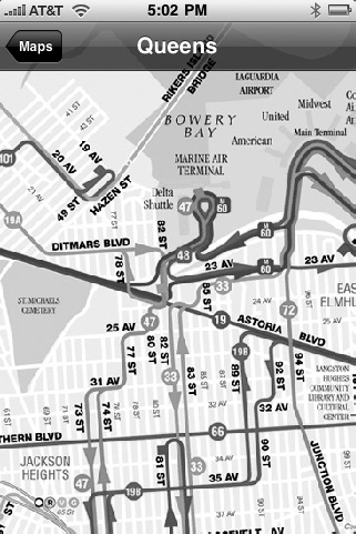
Figure 6.3. Bus riders are currently underserved by most NYC transit apps, so Wegener hopes including line maps will help set Exit Strategy apart as the most comprehensive of its competitors.
The maps seem really easy to do—like, "Oh, you just stick in the map," but that takes hours of the programmer's time. It's actually a big technical challenge, because you have a very large image, and you need to tile, you need to cut it into a thousand different pieces and assemble them quickly and easily. So if you see the way iTransit works, it reloads a section the screen very quickly. It took me and the developer I'm working with about a week to get that right, just having a map alone, a beautiful high-res, zoomable, scrollable map.
The MTA has given us a bunch of really cool data, and they've even kind of gone out of their way to grab some extra data. We'll have the subway map, we'll have all five borough bus maps, we will have possibly the Metro North maps, but the coolest thing that we're going to have is the other half of the piece of the puzzle. Right now we have exit data; we tell you how to get off the train, out the station. But what we'll be adding is enter strategy.
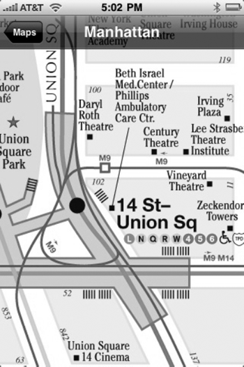
Here's what I mean: when you come through the [subway] turnstiles you see a local neighborhood map. We basically have all of those from the MTA, and are going to be integrating those into the map, so at the bottom of the station screen. So if you're going to Bedford on the L, and you're looking at the exit data, there will be a button at the bottom that says, "flip to neighborhood map," and you can press that, it will take you to an above, to a street map image of the neighborhood, as well as MTA's diagram of the station, which shows exactly where the staircases come above ground. Figure 6-4 shows on of MTA's neighborhood maps.
It'll all be integrated—you'll basically be able to scroll around the neighborhood and use the MTA's neighborhood map, from your phone. It'll show you what's around that stop. For example, in the case of Manhattan, we had about 20 Manhattan maps, and I basically wove them together into this giant quilt, so now we have coverage of a super giant single map that covers all of Manhattan that has every single subway station, where the exits come above ground, and the bus lines drawn on top of it. It has where the staircases are and where the elevators are for every subway station. Originally they were giant Illustrator files of the maps: 30MB files with 600 layers, with every street name, every letter in the word you can change.
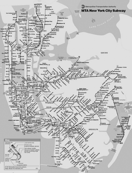
We had to pay the MTA $5,000 to use them; that's 10% of our [projected] profits. (Figure 6-5 shows the official NYC Subway map.)
That's something I've been thinking a lot about. When we launched the app, we were really concerned about this 10MB threshold. Our app right [in version 1.0] is 6MB with 500 station images; people can impulsively buy it if somebody tells them about it at a party, which is cool. And the other two competitors in the subway map market are both are under 7MB. But there's no way realistically we're going to be under 10MB with the amount of information we want to add [to the next version]. So once you pass that restriction, and that constraint is lifted, we decided you can really go crazy. Once we add all these neighborhood maps, the app will probably be between 50 and 100MB.
We decided we'd rather launch early with less data. The app right now has about maybe 60 or 70% of New York covered; it doesn't do the very end of all the lines in the outer-boroughs. If we had gotten fed up and given up earlier, we would've just launched with less data.
By far the biggest market is NYC for anything cool and local. We've had people from Chicago, and Boston, and Washington reach out to us and want us to come do it there, and we even had two people in Washington who wanted to do it and give us a percentage of their profits for using our software. Basically do it under the exit strategy brand for Exit Strategy DC. The truth is it's not worth our time in other cities. A lot of New Yorkers think about this: where do I stand on the train? Not a lot of people in other cities necessarily think about it. I think in Washington it's less of a problem; the trains are shorter and people use them in a different way.
The sad truth is there's more of a market in selling a subway map than there is in this really cool data that we've collected. The original thinking behind the app was this is incredible data that nobody's bothered to collect because there's never been a reason to do it. And now the iPhone app is this brilliant micro-distribution solution, where we can literally charge 99 cents and put it in the hands of a million people. That was the original idea, and what we realized after our third day of being launched, and we were being outsold by iTrans on day 3, what was really depressing was that there is more of a market for the NYC subway map than there is for this cool data.
When the switch flips [on the new app] people overnight are going to see Exit Strategy develop into this beautiful butterfly. And hopefully they are going to be blown away, and go Tweet about it, and we'll try to do like kind of a second press launch. And the fact that we have this install-base that's getting it for free gives us word of mouth marketing powers, is my thinking. And once we get the update pushed to the store, we plan to raise the price.
We did have plans to release a light version, that maybe only includes a single subway line so like just the 1 line data or something like that, to give people sort of a taste of what the app does and get them hooked on using it for one line. We just never really got around to it. We got distracted by other things, and then we started kind of working on version 2.0. It's going to be hard to make a light version of 2.0 unless we take what we have now and we make it Exit Strategy lite with just the exit data.
I hate the 99 cent price-point. I think it's really a ridiculous price-point. I see so much awesome software and it's really depressing that they're selling it for that pathetically low price. I knew we didn't want to do 99 cents, and we originally had thought we'd price this about $3.99 or $4.99 when we launched. And we talked to a whole bunch of friends, and interviewed everyone we knew with an iPhone. We kind of heard the same thing from everyone: I would never buy an app that costs more than $1.99. So we launched at $1.99, and we made the marketing round that the marketing was Less Than the Cost of Subway Ride! It got a chuckle out of the press, and almost every write put that in.
That was going to be our introductory price, and then we were going to raise it to $3.00 or $4.00, so that's what we did. After a week, we raised it to $3.00. The interesting thing was that there wasn't even a blip in the unit sales, they dropped by maybe 3 or 5% when we increased the price from two to three bucks. We should've done it [from the beginning] in retrospect; they were willing to pay $3.00 if they were willing to pay $2.
The barrier is once you get past, in my mind, $4.00. Anything over $4.00 is this premium price-point, where I'm not going to care if it's $8.00, $9.00, or $10.00. The most expensive thing I bought was a $10.00 app, the racing game from the Flight Control people.
I did try a $4.00 price-point for our current product, Exit Strategy 1.0, for a period, and we did see a revenue drop-off. So, I think there's always an ideal price-point, and it's fairly easy to test that. You just sort of increase or decrease the price until you figure out what that price-point is. So the really tough thing is launching a product like we did, because you don't have that knowledge, you don't have that market data, and you're completely going in the dark.
What we ultimately learned is that the people that care about where to stand on the subway, there's a lot of them, and they're really passionate about it, and they would pay $4.00 or even maybe $5.00. Or they couldn't care less and they wouldn't even pay a penny for it. So I think by trying to price it at this point where everyone could afford it and where everyone we thought would get it, which was our $2.00 launch price-point, in retrospect, that was a mistake.
We very carefully made out our press strategy, and put out a media kit complete with images and videos. This whole cute story was sort of designed to be press-worthy. If I had paid someone on Craigslist $50.00 a day to go ride around, it would be a lot less interesting than the dedicated brother-sister team doing it. So, we definitely did everything with press in mind.
The New York Times broke the story with an exclusive. They had a copy of our app two weeks prior; I had gotten an introduction to someone at the CityRoom section. We had set up a connection at Thrillist, too, and it kind of took off from there. The day of launch, the Times came out with it 7:30 in the morning, at 10am I had a phone call from Wired magazine, then at 11am I had the New York Post on the phone. They all just sort of came to me. Putting my phone number on the press kit was one of the best things that I could've done.
We actually released this on four different platforms. We have it on iPhone, we have it on Blackberry, Android, and even as an eBook in Kindle. And that was really because of the design of it and the way we used images made it really easy to port.
The iPhone is 95% of the sales, but I wanted to have experience working across three different platforms.
In terms of porting it, it was really easy. My friend did it for us on Android in about 12 hours. Just because he was able to drag and drop the images in the database, and everything just transferred between platforms very easily because of that design.
There are two lessons. One is do your market research. I can't overstate that. The other lesson would be launch with the simplest product you can, the minimal viable product, or "MVP." Don't spend $50,000 in two years developing a product. Ours is incomplete; we don't even have the rest of NYC, and we get emails everyday from people that are angry that we don't have Avenue X on the Q line or something. Just get your product to market as quickly as you can, and improve it later, once you've discerned that there is a demand for your product.
[9] To read how Jonathan, Ashley and their developer strategized for version 2.0, check out Chapter 12.