
In this chapter, we will explore the exciting new 3D capabilities of ArcGIS Runtime. 3D is a major new feature that will bring 3D viewing capabilities while at the desktop or in the field on a mobile device for the first time. At this point in time, 3D is only available in the .NET version of ArcGIS Runtime (Windows, Windows Store, and Windows Phone), but it is expected to be released to all flavors when the Quartz (next major release) version of ArcGIS Runtime is available. To start off, we'll see how easy it is to change a 2D map to 3D, and then we'll discuss how to navigate in 3D, adding layers to a 3D scene, creating surface models, and so on, all of which will be done with the MVVM pattern. We'll discuss the following topics:
- Why 3D?
- From 2D to 3D
- Navigating in 3D
- 3D layers
- Surface models
- MVVM in 3D
- 3D content
Before we discuss how to change from 2D to 3D, it's important to understand why 3D is necessary. There are many reasons:
- Our world is of course 3D, so humans naturally are able to interact with a map in 3D in a more natural way than in 2D. 3D is more realistic than 2D, so it makes understanding a design or analytical output easier.
- For some applications of GIS, a 2D map is simply insufficient. If you're a military mission planner, 3D is just not a nice feature, it's a must. Imagine if you were trying to determine if an inbound flight had enough clearance to pass over some buildings. Without 3D, this would be impossible, so lives would be at risk.
- 3D allows urban planners to try out different designs before ever building anything. Using 3D allows the planner to see different possibilities to ensure other views aren't blocked or that a new building's shadow won't be cast on the other buildings using an artificial light source, which can be determined at different times of the year.
- 3D is also every helpful from an analytical perspective. Imagine modeling a flood in 2D. You'd be able to view the area of the flood but not the depth. Without the depth, we can't actually see how many floors of buildings would be inundated or whether a bridge would be covered. Another analytical example would be the use of 3D to determine whether the viewer can see something based on their line of sight (LOS).
- With 3D, improved modeling is possible. Maps have always been rough approximations of the Earth. With 3D, GIS, and new sensor technologies, such as Light Detection and Ranging (LiDAR), Radar, and Synthetic Aperture Radar (SAR), the ability to model the surface of the Earth has greatly improved, so it's now possible to make very detailed maps in 3D, which accurately show the position of objects in all three dimensions.
- With all of the sensors available in today's smart phones and tablets, 3D is the perfect environment to exploit them because these sensors can take advantage of the 3D nature of our world. For example, photographs or videos taken with smart phones are orientated and placed into their proper position in 3D. In addition, sensors allow us to measure the distance and height of objects so that we can correctly place them or even remove them from a scene.
- The Augmented Reality (AR) is about placing digital information on top of whatever you are viewing on your device. A perfect example of AR is a head-up display (HUD) used by pilots that allow them to access critical information, such as speed and heading, while seeing the real world. Another example is a utility field, where the user could point their phone around them and see underground water pipes in their exact position.
- The Virtual Reality (VR) toolkit allows a user to place themselves into the 3D scenes using head-mounted displays. Another military example of this is where VR helps soldiers train for battlefield scenarios. An example of this is the Synthetic Environment Core of the U.S. Army, where soldiers are able to navigate through virtual environments, as shown here:
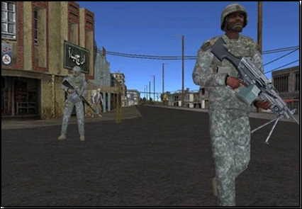
Soldiers who navigate through viral environments
The preceding image is available at http://www.peostri.army.mil/PRODUCTS/SECORE/images/2012_SECore-Dismount.gif.