
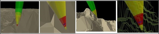
In the current version of ArcGIS Runtime, multipatch geometry is not supported. This kind of geometry is available in ArcGIS Desktop and ArcGIS Engine via ArcObjects. With multipatch geometry, it is possible to virtually create any shape, such as the clearance cones around a missile's trajectory, by using triangle strips, triangle fans, triangles, and rings. Here's an example:
This kind of capability will eventually make it to ArcGIS Runtime as the 3D capabilities are expanded. For now, you can still create multisided shapes with the example code that follows, and apply PictureFillSymbol to them as a form of texture if needed:
// outline
SimpleLineSymbol sls = new SimpleLineSymbol()
{
Color = Colors.Black, Style = SimpleLineStyle.Solid, Width = 2
};
// fill symbol
SimpleFillSymbol sfs = new SimpleFillSymbol()
{
Color = Colors.Red,
Style = SimpleFillStyle.Null,
Outline = sls
};
// renderer
SimpleRenderer sr = new SimpleRenderer();
sr.Symbol = sfs;
// Graphics Overlap
GraphicsOverlay graphicsOverlay = new GraphicsOverlay()
{
RenderingMode = GraphicsRenderingMode.Dynamic,
Renderer = sr,
SceneProperties = new LayerSceneProperties()
{
SurfacePlacement = SurfacePlacement.Relative
}
};
// bottom of box
List<MapPoint> bottomList = new List<MapPoint>();
bottomList.Add(new MapPoint(71.75, 36.5, 10000, SpatialReferences.Wgs84));
bottomList.Add(new MapPoint(71.75, 37.5, 10000, SpatialReferences.Wgs84));
bottomList.Add(new MapPoint(72.75, 37.5, 10000, SpatialReferences.Wgs84));
bottomList.Add(new MapPoint(72.75, 36.5, 10000, SpatialReferences.Wgs84));
// West Side of box
List<MapPoint> westSideList = new List<MapPoint>();
westSideList.Add(new MapPoint(71.75, 36.5, 10000, SpatialReferences.Wgs84));
westSideList.Add(new MapPoint(71.75, 36.5, 60000, SpatialReferences.Wgs84));
westSideList.Add(new MapPoint(72.75, 36.5, 60000, SpatialReferences.Wgs84));
westSideList.Add(new MapPoint(72.75, 36.5, 10000, SpatialReferences.Wgs84));
// West Side of box
List<MapPoint> eastSideList = new List<MapPoint>();
eastSideList.Add(new MapPoint(72.75, 36.5, 10000, SpatialReferences.Wgs84));
eastSideList.Add(new MapPoint(72.75, 36.5, 60000, SpatialReferences.Wgs84));
eastSideList.Add(new MapPoint(72.75, 37.5, 60000, SpatialReferences.Wgs84));
eastSideList.Add(new MapPoint(72.75, 37.5, 10000, SpatialReferences.Wgs84));
// South Side of box
List<MapPoint> southSideList = new List<MapPoint>();
southSideList.Add(new MapPoint(71.75, 36.5, 10000, SpatialReferences.Wgs84));
southSideList.Add(new MapPoint(71.75, 36.5, 60000, SpatialReferences.Wgs84));
southSideList.Add(new MapPoint(71.75, 37.5, 60000, SpatialReferences.Wgs84));
southSideList.Add(new MapPoint(71.75, 37.5, 10000, SpatialReferences.Wgs84));
// North Side of box
List<MapPoint> northSideList = new List<MapPoint>();
northSideList.Add(new MapPoint(71.75, 37.5, 10000, SpatialReferences.Wgs84));
northSideList.Add(new MapPoint(71.75, 37.5, 60000, SpatialReferences.Wgs84));
northSideList.Add(new MapPoint(72.75, 37.5, 60000, SpatialReferences.Wgs84));
northSideList.Add(new MapPoint(72.75, 37.5, 10000, SpatialReferences.Wgs84));
// Top side of box
List<MapPoint> topList = new List<MapPoint>();
topList.Add(new MapPoint(71.75, 36.5, 60000, SpatialReferences.Wgs84));
topList.Add(new MapPoint(71.75, 37.5, 60000, SpatialReferences.Wgs84));
topList.Add(new MapPoint(72.75, 37.5, 60000, SpatialReferences.Wgs84));
topList.Add(new MapPoint(72.75, 36.5, 60000, SpatialReferences.Wgs84));
// create polygons of box
Polygon bottomPolygon= new Polygon(bottomList);
Polygon topPolygon = new Polygon(topList);
Polygon westSidePolygon = new Polygon(westSideList);
Polygon southSidePolygon = new Polygon(southSideList);
Polygon northSidePolygon = new Polygon(northSideList);
Polygon eastSidePolygon = new Polygon(eastSideList);
// create graphics of box
Graphic bottomGraphic = new Graphic(bottomPolygon);
Graphic topGraphic = new Graphic(topPolygon);
Graphic westSideGraphic = new Graphic(westSidePolygon);
Graphic southSideGraphic = new Graphic(southSidePolygon);
Graphic northSideGraphic = new Graphic(northSidePolygon);
Graphic eastSideGraphic = new Graphic(eastSidePolygon);
// add graphics to overlap
graphicsOverlay.Graphics.Add(bottomGraphic);
graphicsOverlay.Graphics.Add(topGraphic);
graphicsOverlay.Graphics.Add(westSideGraphic);
graphicsOverlay.Graphics.Add(southSideGraphic);
graphicsOverlay.Graphics.Add(northSideGraphic);
graphicsOverlay.Graphics.Add(eastSideGraphic);
// add overlay
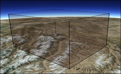
this.sceneView.GraphicsOverlays.Add(graphicsOverlay);The resulting box will look like the following screenshot, and could represent an airspace deconfliction area:
..................Content has been hidden....................
You can't read the all page of ebook, please click here login for view all page.