Chapter 11. Real-World Applications
Beneficial Drones
When used safely and responsibly, small UAVs can be flown for a wide range of applications. When we speak to students, they constantly come up with creative new uses for the technology. UAVs can greatly benefit industries, people, and our planet. Many universities now offer majors in unmanned aerial systems. The first, the University of North Dakota, began its program in 2009, and Kansas State University was the second US college to offer a UAS major. The need for UAVs in agriculture is what pushed schools in the Midwest to lead the way.
Here, we will explore what we feel are the top real-world beneficial applications for UAV use. This list is just the beginning of how drones are helping save time, money, and lives.
Aerial Photography
The desire to create photography with a unique feel and perspective is a strong motivator that gets many into the hobby of UAVs (see Figures 11-1 and 11-2). Lightweight, durable action sports cameras have played a key role in the popularity of small drones. The ability to view larger areas and gain a clear sense of an environment has led to applications in the motion picture industry, sports broadcasting, and journalism. We started off using Terry’s homemade UAVs for photographing landscapes and architecture in 2010.
UAV and camera technologies continue to progress rapidly. At this point, we prefer flying with a micro four thirds camera model—basically a hybrid between point-and-shoot and full size DSLR model. An important feature to have is a remote sensor that enables you to trigger the shutter from the ground. Another method is to set the camera to take pictures at regular intervals, say every five seconds or so. We have found that a two-person team works well to compose the best shots. The pilot is able to concentrate on operating the aircraft, while the camera operator uses a second controller for the gimbal and camera. A ground station monitor enables you to see the view from the on-board camera and refine your aerial position to capture the final composition.
Refer back to Chapter 8 for more information on UAV camera equipment.

Figure 11-1. Francis Scott Key Monument, Baltimore, MD, taken with Sony NEX-5n.
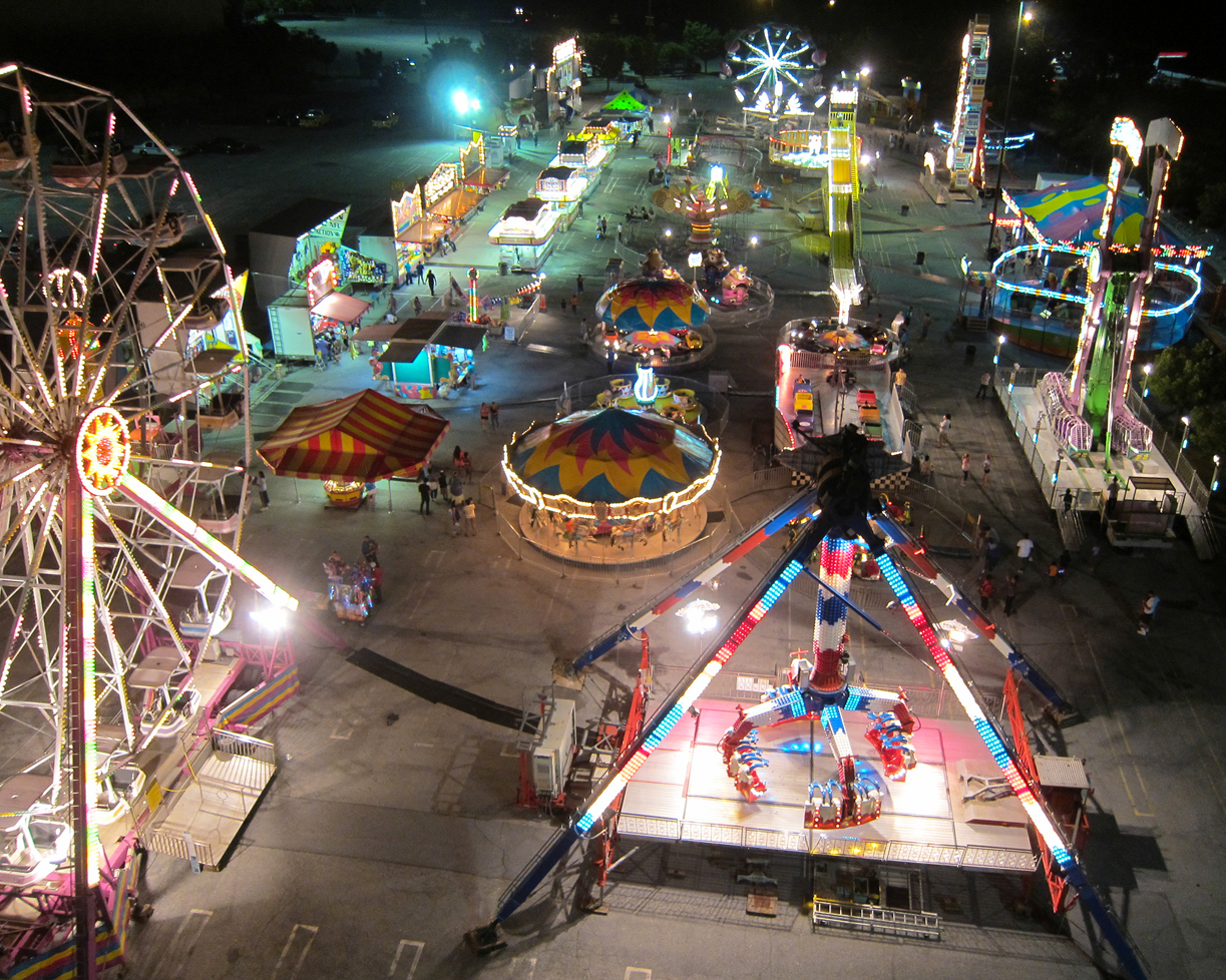
Figure 11-2. Firemen’s Carnival, Baltimore, MD, taken with Canon S95.
Mapping and Surveying
Drones are proving to be an efficient tool that is revolutionizing the field of geographic information systems (GIS). The drone’s payload can collect a range of data using cameras and sensors. These devices, used along with geo-referenced ground markers, produce highly accurate maps with a resolution up to five centimeters per pixel.
Two main types of software are involved in UAV mapping. The first type is for mission planning, and the second is for data processing. The UAV flies in a lawnmower pattern autonomously (see Figure 11-3). Several mission planning applications are available including free, open source apps. The mission is uploaded to the UAV in its entirety. While flying the mission, the payload points straight down and captures data at regular intervals, creating overlapping images of the area—at least 60% front to back and 40% side to side. Once the data is collected, it is processed by removing distortion and stitching images to create an ortho rectified mosaic. As with the navigation software, there is also a range of data processing solutions from locally installed applications to cloud-based services.

Figure 11-3. The white line shows a UAV mapping flight path in a lawnmower pattern.
Precision Agriculture
New technology is essential for keeping up with the nutritional needs of a growing population. With 2.2 million farms in the United States alone, precision agriculture will benefit immensely from small UAVs. Farmers, agronomists, and farm support service providers are all aware of this and are more tech savvy than you may think. Drones are less expensive and more accessible than regular airplanes. UAVs can also complete the tasks previously done with manned aircraft much faster with more precise results. Additionally, because farms are generally located in scarcely populated areas, privacy and safety issues regarding drones are much less of a concern.
There are two main areas in which UAVs assist farmers. The first is with GIS, and typically utilizes a fixed wing style of drone aircraft. They do not require as much power, which helps them stay in the air longer. By gathering data from infrared sensors and stitched image files, farmers are able to efficiently map the farm, estimate crop yields, assess plant health, identify weeds or diseased plants, record plant growth, and measure hydration levels. All of this information is then analyzed and used to make the best crop management decisions. Prescriptions for fertilizers and pesticides can then be selectively applied to individual plants in an improved field plan. This is where the second type of UAV aircraft comes in. Helicopters or multirotors capable of carrying a payload are used to spray various prescribed formulas, row by row, precisely onto only those crops that need it.
Successful UAV precision agriculture programs are found in Canada, Brazil, and Sweden, but the standout model is in Japan. The Japanese Agriculture Ministry commissioned Yamaha to develop an unmanned aerial system for agriculture in 1983. The Yamaha RMAX unmanned helicopter has been spraying crops since 1991. Today, the RMAX sprays 40% of Japan’s rice fields, approximately 2.5 million acres. Their yield increase has been estimated as high as 30% while maintaining an impeccable safety record. Drones will indeed revolutionize farming.
Search and Rescue
Drones have assisted many times in the successful location of missing persons, whether the incident was due to a natural disaster, abduction, or simply getting disoriented and lost. A UAV equipped with a high-resolution camera or infrared sensor can search hundreds of acres in a matter of minutes. To cover the same area on the ground would take dozens or hundreds of volunteers hours or even days. The initial period of time from when a person is first reported missing is the most crucial, and mobilizing resources early can make all the difference in finding them alive.
Some examples of teams that are effectively designing or using drones for search and rescue at a fraction of the cost and risk include:
-
Royal Canadian Mounted Police found a family that got lost for days while hiking in a forest near Topsai Lake outside Nova Scotia.
-
New Zealand Coast Guard uses its drones to find people and boats lost at sea. Robolifeguard is a sUAV that has a shark-deterrent module.
-
A Swiss group has developed a drone for tight, indoor missions called the Gimbal UAV. It is housed in a cage that can bounce off obstacles or roll across the ground.
-
David Lesh, an amateur drone user, found Guillermo DeVenecia, an 82-year-old missing man who wandered into a soybean field. After days of searching using other methods, Lesh flew at an elevation of 200 feet and quickly spotted DeVenecia.
-
Texas nonprofit EquuSearch gained widespread attention for filing a petition for review with the US Court of Appeals for the District of Columbia, with a complaint against the FAA for wrongly ordering a cease-and-desist in an email for using UAVs for search and rescue. The court found that the FAA’s email was “not a formal cease-and-desist letter representing the agency’s final conclusion.” Equusearch’s missions have contributed to finding many missing persons.
Infrastructure Inspection
Aging infrastructure and the rise of extreme weather can have disastrous effects on transportation, communication, and energy infrastructure. Inspection of the structures related to these industries is where small UAVs present many advantages over regular manned aircraft (see Figure 11-4). Drones are able to achieve tight close-ups and get into hard-to-reach areas. Safety is another clear advantage. Consider workers who must climb structures or use bucket trucks and cranes to suspend themselves from the sides of massive bridges and skyscrapers. These outdated methods are simply dangerous, time-consuming, and expensive. For the cost of one manned flight, a company can own and operate an entire UAV imaging system.
Being able to hold the UAV at a precise set of GPS coordinates, plus the ability to move an airborne camera in three axes, allows an operator to obtain an extremely clear view of any area technicians would need to get a detailed look at. A live feed allows the inspectors to see in real time what the drone sees. High-resolution files can then be stored and reviewed for making assessments and developing repair strategies.

Figure 11-4. Air-to-air image of the RC Rotors Inspection Drone with camera point straight upward; the X8 is piloted by Beresford Davis, and the photo is by Terry Kilby.
Drones are a game-changer for inspecting numerous structures including:
- Bridges
- Power lines
- Cell towers
- Buildings
- Roofing
- Oil pipelines and rigs
- Nuclear plants (radiation measurement)
- Thermal analysis of buildings
- Gas refinery flare tips
- Water treatment facilities
- Wind turbines
- Smoke stacks
- Hydroelectric plants
- Ships
- Solar arrays
- Historical monuments
- Railways
- Highways (overpasses, tunnels)
- Large equipment (cranes, earth movers)
Conservation
Biologist and climatologists face many difficult challenges in their fight to save our planet’s endangered species and their habitats. They must cover vast, arduous-to-navigate locations. Planning expeditions is expensive, laborious, and time consuming. Conservationists have perished from encountering armed poachers. Many over the years have died flying in light aircraft at low altitudes for their observations. Out of dire necessity, scientists have welcomed the many advantages gained using sUAVs to efficiently complete their work. The speed, safety, and time and cost savings are wonderful. However, the greatest benefit may be the wealth of data from high-resolution images and sensors never before seen, much less gathered. It seems drones have given conservationists renewed hope.