
9
Weather and Atmospheric Science
Experienced landscape astrophotographers understand the weather. Crystal clear skies set the stage for luminous nightscapes. Just the right amount of cloud cover can produce stunning sunset and sunrise images. Treacherous weather, on the other hand, can range from inconvenient to life threatening.
You can learn to plan your trips and venture into the field with confidence by understanding how and why specific weather patterns develop. Here, we will review the weather basics needed for successful nightscape sessions. We will explore the different types of cloud patterns you will encounter and what they mean. We will discuss humidity, dew point and the conditions that cause fog, dew, and frost to form. This information will help you recognize and interpret telltale signs to know what they portend. Finally, we will investigate a variety of atmospheric science phenomena that are of particular interest for landscape astrophotography, including rainbows, noctilucent clouds, lightning, crepuscular rays, ice halos, sundogs, ice pillars, and the green flash.
Clouds
You will most likely want to conduct your nightscape sessions under the cloudless, low humidity skies that accompany large, stable regions of high air pressure. Not surprisingly, desert regions around the world are known for these conditions. When two or more air masses of differing pressures interact, however, clouds and inclement weather can develop within them and along their boundaries. Understanding the characteristics and movements of air masses is thus important, yet we can’t “see” air. Instead, we are forced to rely on the features of whatever clouds may be present in order to deduce the characteristics of the prevailing and impending weather.
Clouds can be put into one of three broad, somewhat overlapping classifications based on the altitude range in which they occur: low (surface to 6,500 feet), middle (6,500–25,000 feet) and high (10,000–60,000 feet), Figure 9.1(a). High-level clouds are made up of ice crystals and include cirrus, cirrocumulus, cirrostratus and noctilucent clouds, Figure 9.1(b, c). Mid-level clouds are generally made up of water droplets but can include ice crystals under the right conditions. Examples of mid-level clouds include altocumulus, altostratus, and nimbostratus clouds, Figure 9.1(d, e). Low-level clouds are usually comprised of water droplets and include cumulus, stratocumulus, stratus, and cumulonimbus clouds, Figure 9.1(f, g).
The shape and texture of clouds are affected strongly by whether they are comprised of water droplets, ice crystals, or a combination of both. Wispy, feathery clouds are typically comprised of ice crystals; rounded, billowing clouds are comprised of water droplets. The delicate ice crystals of cirrus clouds are a perfect canvas for the peaceful colors of alpenglow, Figure 9.1(c). Conversely, the soft, water-droplet based undersides of altostratus clouds can yield dramatic images, especially at sunset. In fact, keep an eye out for those occasions when the setting sun may slip into that narrow, open band of sky just below the flat layers of altostratus clouds but above the horizon; stunning images are frequently possible, Figure 9.1(f). Towering stacks of cumulonimbus clouds internally lit by flashes of lightning during late evening thunderstorms can be unforgettable, especially during their transformation from enormous masses of water droplets to gently dispersing drifts of ice crystals, Figure 9.1(e).
The region between two air masses of differing densities is known as a weather front. In general, one of the air masses is encroaching upon the other. The temperature of the advancing air mass

9.1
(a) Types of clouds characterized by altitude. (b, c). High-level clouds are made up of ice crystals and include noctilucent, cirrus, cirrocumulus, and cirrostratus clouds. (d, e) Mid-level clouds are generally made up of water droplets, but can include ice crystals under the right conditions. Examples of mid-level clouds include altocumulus, altostratus, and nimbostratus clouds. (f, g) Low-level clouds are usually comprised of water droplets and include cumulus, stratocumulus, stratus, and cumulonimbus clouds.
Source: (b) P-M Hedén/ www.clearskies.se /The World At Night
is used to describe the front: a cold front occurs when a mass of cold air moves into a region of warmer air, and vice versa. The air masses on either side of a front have differing combinations of air pressure, temperature, and humidity. Clouds develop within frontal regions owing to these differences, and their features are reliable indicators of each weather front’s unique characteristics.
Specific clouds form ahead of different types of fronts. They can be analyzed to predict the likely pattern of imminent weather. For example, ice-crystal based cirrus clouds are often early harbingers of deteriorating weather, since they can develop at the initial edges of an incoming warm front. Altostratus and then stratus clouds with possible rain can follow in the hours and days ahead. In contrast, large water vapor-based cumulus and cumulonimbus clouds typically develop along the edges of a cold front and signal imminent precipitation and cooler temperatures.
Other clouds, such as altocumulus and widely disbursed cumulus clouds are reliable indicators of fair weather and imminent clear skies, Figure 9.1(g), especially if they are decreasing in size. As a landscape astrophotographer, it is well worth understanding which ones are which.
Finally, tenuous noctilucent clouds deserve a special mention. These are a relatively rare, yet beautiful phenomenon restricted to relatively high latitudes, typically 50° to 65° north/south of the equator, Figure 9.1(b). Noctilucent clouds sit at altitudes of around 250,000–280,000 feet. They only become visible in the dim light of twilight, well after sunset and before complete darkness, owing to their very low levels of light reflection.
Absolute Humidity, Relative Humidity, and Cloud Formation
What are clouds, after all? Some have already been described as being comprised of ice crystals, and others of water droplets. How exactly do they come into existence; why and when do they transform from one form to another? The answers begin with the fact that air always contains a small amount of water vapor, typically between a few tenths to several percent of the total air pressure, depending on its temperature. Water vapor is an invisible gas that is simply part of the air we breathe. Let’s establish a few basic concepts and terms that will help us understand how, and under what conditions clouds, dew, and frost develop.
Air at any temperature is able to hold only a certain amount of water vapor before it becomes saturated, and unable to absorb, or hold any more. The maximum amount of water vapor that air can hold at a given temperature is called its saturation water vapor.
The amount of water vapor contained within a given volume of air is known as its humidity, and can be quantified in two different ways. The absolute humidity is the actual mass of water vapor within a given volume of air, and can be expressed in terms of grams per cubic centimeter. A more familiar term, however, is the relative humidity, which is the ratio of its actual amount of water vapor, i.e. it’s absolute humidity, compared to its saturation water vapor.
Once a given volume of air has become saturated, we say that it has achieved 100 percent relative humidity. If a comparison volume of air is holding exactly half the quantity of water vapor as a first, saturated volume of air, and is at the same temperature, then we say the second volume has a 50 percent relative humidity; this is because it’s only holding half the amount of water vapor it can hold before becoming saturated. Here’s a tip from the field to gauge the prevailing relative humidity: try to see if you can spot any high-altitude airplanes, and if you can, the length and characteristics of their contrails. Long, highly textured contrails generally indicate higher relative humidity; short to absent contrails indicate low relative humidity, the best condition for clear views of the night sky.
The dew point is the temperature at which air of a given absolute humidity becomes saturated. Warm air is able to hold more water vapor than cold air before becoming saturated. Air with a high absolute humidity thus has a higher dew point than air with a lower absolute humidity.
If the temperature of air is cooled below its dew point, some of its water vapor condenses into either microscopic water droplets or ice crystals. Alternatively, if a given volume of air is already saturated, or at 100 percent relative humidity, and additional water vapor enters it, say from a second air mass, the additional water vapor is unable to remain as a vapor and instead condenses into either microscopic water droplets or ice crystals. In either case, if these tiny water droplets or ice crystals remain suspended in air, they form a cloud or rain/snow; if they are deposited on surfaces, they form dew or frost. These are the primary mechanisms of cloud, dew and frost formation.
All clouds form as the result of air reaching a temperature below their dew point. Stated alternatively, all clouds form when air exceeds its saturation limit. In either case, you can now see why any natural phenomenon that causes either of these results (cooling or introduction of excess moisture) causes clouds to form. Also, you can understand that the specific features of the clouds that form reflect the details of the manner in which the dew point and/or saturation limit were exceeded. Water droplet-based clouds form at relatively warm temperatures; ice crystal clouds form at colder temperatures.
This understanding can also help you appreciate the mechanisms of the daily cloud formation and ultimate dissipation sequence that regularly occurs over mountain ranges, especially during the summer months. The cycle begins when throughout the day, winds develop and pull warm, moist air from lower altitudes up the mountains to the cooler temperatures of higher altitudes. This process decreases the air’s temperature well below its dew point. When this occurs, significant afternoon and evening thunderstorms can quickly develop. These energetic storms often produce dangerous lightning, sudden downpours of rain or snow, and even hail. As the day progresses, the water droplets originally comprising the thunderheads often cool and transform into ice crystals, yielding a pleasant, wispy backdrop to the day’s sunset, Figure 9.1(e). Finally, as evening proceeds, the winds typically diminish and die down altogether, bringing an end to the process and allowing the clouds to completely dissipate into clear skies. It is thus not at all uncommon for such cycles to produce spectacular later afternoon and evening thunderstorms, with gorgeous sunsets and alpenglow on the lingering clouds, followed by crystal-clear skies overnight only for the cycle to be repeated the following day.
Dew, Frost, and Ground Fog
We can now understand why dew and even ice crystals can form on our camera lenses as night progresses, especially in humid environments. These processes can very effectively end the night’s session. As we have seen, dew or frost condenses any time the air temperature drops below its dew point. What makes matters worse is that objects on the ground, like your camera lens, can actually cool to temperatures a few degrees below the actual air temperature when they are exposed to the clear night sky. This cooling occurs through radiative heat transfer, which simply means that the ground object is radiating, or losing heat directly into the night sky, faster than the surrounding air. The consequent decrease in temperature of your camera lens causes the air immediately adjacent to it to cool to a temperature a few degrees colder than the ambient air. This is often enough to trigger dew or frost formation. This local radiative cooling of objects exposed to the clear night sky is the cause of frost formation on patches of grass in an open field during clear nights while grass just a few feet away but under the protective shield of tree branches remains frost-free, even though they both experience the same overall ambient air temperature.
When dew or frost begins to condense on your lens, simply blowing on the lenses is of no help. Doing so simply causes additional dew or frost to condense from the very high humidity of your exhaled air! Instead, the only solution is to gently warm the lenses slightly in an effort to induce any condensed water to evaporate, or frost to sublimate. Commercial lens heaters are available designed specifically for this purpose. Alternatively, a do-it-yourself solution is to attach disposable hand warmers to the camera lens and with rubber bands or tape, as described in Section V. Another do-it-yourself approach is to create an insulating lens hood from elastomeric foam, such as the type found in camping mats, to shield the lens from the night sky. Astronomers frequently use such hoods on their telescopes for just this purpose. However, the very wide-angle lenses often used for nightscape imaging typically preclude the use of lens hoods, which can substantially vignette the field of view.

9.2
The beam of this lighthouse in Cape Hatteras, North Carolina, illuminates a hazy ground fog, which typically forms under clear skies with locally high humidity. In such situations, care must be taken to avoid lens condensation.
Finally, ground fog may occur as the result of the cooling of the air as night progresses. Typical conditions for the formation of ground fog are when warm, relatively high humidity air encounters a region that is much cooler. Very common over lakes, ponds, and oceans, ground fog occurs when high humidity air from just above the surface of the relatively warm pond or lake encounters much cooler ambient air, Figure 9.2. Ground fog can also occur at night under clear skies when the ground temperature drops as a result of radiative cooling. Unfortunately, when ground fog strikes the only solution is to seek higher ground or to head home!
Rainbows, Ice Halos, Ice Pillars, and Sun/Moondogs
Let’s now examine a few of the highly photogenic atmospheric phenomena that you may encounter under the right conditions. Specifically, we will explore the atmospheric optics of rainbows, moonbows (Figure 5.13), ice halos, sundogs, and ice pillars. Like most of the other subjects in this book, you will greatly increase your chances of observing them if you are able to understand and intentionally seek out the situations in which they form.
All these phenomena originate from the refraction and reflection of sunlight or moonlight from within floating water droplets or ice crystals, Figure 9.3 (overleaf). As light passes into the water droplets, Figure 9.3(a), or ice crystals, Figure 9.3(b), it refracts and reflects from the inner surfaces back to the observer on the ground. In doing so, its spectral colors are dispersed.1 Consequently, in order to observe rainbows or moonbows in mist, rain showers, or clouds, it is important to have the sun or the moon at your back, as shown for the case of rainbows in Figure 9.3(a). Second, owing to the geometry of the shallow angles of dispersion, rainbows and moonbows are generally only observed when the sun or moon are close to the horizon, in other words, near sunset or sunrise for rainbows.
While all ice crystals develop as a result of conditions beyond their saturation limit, the precise details of local temperature and ice supersaturation greatly affect their ultimate shape and size, Figure 9.4. A few of these specific structures have properties that are highly relevant to landscape astrophotography. Supersaturation is a curious phenomenon that occurs when, under the right conditions, extremely small droplets of water vapor can temporarily persist in the liquid form even though the prevailing combination of temperature and pressure dictates that they should freeze into ice. As these miniscule droplets of water grow larger, they eventually crystallize and allow additional water vapor to condense on them in the solid form, further increasing their size and becoming ice crystals or snowflakes, depending on local conditions.
Under relatively low levels of supersaturation and mild to extremely cold temperatures, short, flat hexagonal plates are the favored morphology to form, Figure 9.4. For temperatures between approximately −3° C to −10° C and colder than around −21° C; and moderate levels of ice supersaturation, elongated ice pillars, become the favored shape to develop instead. Plates and columns are of special interest since these miniature prisms enable the observation of many of the atmospheric phenomena described above. First, their angled shapes allow light oriented at very specific angles, relative to the viewer, to be reinforced or dispersed into the colors of the rainbow, Figure 9.3(b). Second, ice crystals with these shapes tend to become physically aligned as they float suspended in the air, owing to the forces of air resistance acting similarly on their shapes. In doing so, favorably oriented light refracted from all of the ice crystals tends to align, synchronizing and consequently amplifying their effects.

9.3
(a) Optics of rainbow/moonbow formation. (b) Optics of ice halo formation from either the sun or moon. In both cases, incoming light from the sun or moon is refracted, or bent, at the interface between the air and the water or ice, and then the light is dispersed within the water or ice into its different colors. The dispersed light is then refracted a second time when it leaves the water or ice. For rainbows or moonbows, the dispersed light is internally reflected in order for it to be redirected towards the viewer. The very specific angles of these processes are what lead to the perception of the different colors of the rainbow or moonbow, as well as the distinctive halo resulting from ice crystals.

9.4
Different shapes and relative sizes of ice crystals and snowflakes develop for different combinations of temperature and ice supersaturation within the atmosphere, as shown in this schematic. We are particularly interested in the conditions for the formation of (i) flat solid plates and (ii) solid prisms or columns, since they are especially auspicious for the observation of ice halos, moondogs, ice pillars and a variety of arcs and rays, for example, Figure 9.5.
These two reasons are the underlying causes of sundogs and moondogs, ice pillars, and arcs. Namely, enormous numbers of floating, aligned ice crystals refract and reflect light to ground-based observer at the same, very specific angles for each of these beautiful phenomena. These phenomena can be see any time of year, although the fall, spring, and especially winter months are the best for observers in the Northern Hemisphere since these are the seasons when the jet stream, with its treasure troves of these tiny, floating ice crystals, moves further south, bringing rich quantities of these miniscule jewels along with it.
A particularly striking example of these phenomena is shown in Figure 9.5(a), where several moon arcs and rays, including a rare, paraselenic circle, are visible along with prominent moondogs on either side of the moon. The geometry of these striking phenomena is illustrated in Figure 9.5(b).

9.5
(a) A circumscribed halo combined with a full paraselenic circle, two moon-dogs, and a 120° parhelion, as illustrated by the schematic in (b). They were photographed on a cold day near Fisher, Minnesota.
Source: Mike Crawford/ http://ctkmedia.smugmug.com
Moon (and Sun) Corona
A moon corona, for example, Figure 5.9(b), forms as the result of light diffraction and interference around tiny water droplets. Unlike a halo, coronas do not involve light actually passing through the liquid droplets of water. Instead, owing to the small size of the droplets, light actually bends, or diffracts around them in much the same way ocean waves bend, i.e. diffract, around a breakwater or jetty. When light from opposite sides of the water droplets meet and recombine, they produce the colors of the spectrum through the process of optical interference. The key requirements are that the moon be directly opposite the clouds from the observer, and that the water droplets comprising the clouds be sufficiently small. Thus, fine, wispy clouds tend to produce more distinct coronas, whereas thicker clouds simply diffuse the moonlight into a uniform glow.
Lightning
The fusillades of lightning and thunder that accompany a rollicking summer thunderstorm can be exhilarating, provided they are viewed from a safe haven! Bolts of lightning both within towering thunderheads, as well as cloud-to-ground lightning strikes are truly one of nature’s most humbling spectacles. When they occur during twilight, or even during the night, such displays of nature’s immense power can yield incredible, once-in-a-lifetime night photography opportunities, provided the photographer understands how to prepare for and safely capture these elusive moments.

9.6
From the photographer, “Thunderstorm rages against starry backdrop, seen from Haleakala volcanic summit on the island of Maui, Hawaii. Lightning appears in the supercell with the shelf cloud under it.”—Babak Tafreshi.
Source: Babak Tafreshi / www.dreamview.net / www.twanight.org /The World At Night
Lightning is simply the flow of electricity through air that has been turned into an electrical conductor. The normally insulating molecules of oxygen and nitrogen that comprise the bulk of our atmosphere are ripped apart and ionized by the lightning. The lightning results from the tremendously powerful electrical fields generated during a thunderstorm, thus turning the air molecules into carriers of electrical charge. This process of splitting and then recombining of air molecules is the cause of thunder. It also produces the flashes of lightning and other electromagnetic radiation, sometimes detectable as static bursts and crackling on AM radio receivers.
There are two primary ways to photograph lightning strikes. The first is to simply set your camera to collect a series of photographs at regular intervals during a storm. Hopefully, one of them will contain a lightning strike! Such sequences can also be stacked to combine multiple strikes into a single, stunning composite image using any of the techniques described in Section VI. The second approach is with the use of a commercially available “lightning trigger” that automatically detects a lightning strike and triggers your camera with no intervention from the operator.
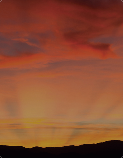
Crepuscular Rays
Crepuscular rays, or “god-rays,” are simply shafts of sunlight that form whenever clouds, mountains, or other objects partially block the sun, Figure 9.1(d), and Figure 11.20. They can be incredible spectacles during sunsets and sunrises, and are worth seeking if the conditions are auspicious. Anti-crepuscular rays, while less frequent owing to their much dimmer appearance, can sometimes also be seen at the same time, although in the side of the sky opposite the setting/rising sun.
The Sun’s Appearance Next to the Horizon and the Green Flash
One of the more distinctive phenomena that accompanies sunset, especially over the ocean or sea, is the significant distortion of the sun’s appearance, Figure 9.7(a). This has been concluded to result from the stratification of the earth’s atmosphere, and the ways in which the sunlight interacts with the individual layers, or strata.
This stratification can lead to the very rare “green flash,” a remarkable phenomenon that can accompany the distortion of the sun during sunset or sunrise, Figure 9.7(b). It occurs because of atmospheric refraction of the sun’s rays, as described in the next section. While the sun’s blue light has been long lost through atmospheric scattering, as described in Chapter 3, the green component of sunlight remains. Owing to the peculiarities of atmospheric refraction, the green light from the sun is refracted at a very slightly different angle than the orange and red colors so that the green sunlight sets approximately 1½ seconds after the last red sunbeam. This phenomenon is called the green flash, owing to its greenish tint and short duration.

9.7
(a) The circular shape of the sun can become very distorted under conditions of severe atmospheric stratification. (b) The “green flash” occurs when green light from the sun, which is refracted at a slightly different angle than the orange and red colored sunlight of sunset, appears for only approximately one and one-half seconds after the last red sunbeam disappears in a brief, greenish “flash.” Good conditions for viewing the green flash are those of significant atmospheric stratification, as seen here.
Bibliography
Greenler, Robert, Rainbows, Halos and Glories, 1980, Cambridge University Press, Cambridge, England
Knight, Randall D., Physics for Scientists and Engineers, Third Edition, 2013, Pearson, Glenview, Illinois
Renner, Jeff, Lightning Strikes, 2002, Mountaineers Books, Seattle, Washington
Schneider, Stephen E. & Thomas T. Arny, Pathways to Astronomy, 2015, Fourth Edition, McGraw Hill Education, New York
Note
1 Sir Isaac Newton, who observed that sunlight separated into its constituent colors after passing through glass, water, and other transparent media, first documented the phenomenon of dispersion. The underlying physical property responsible for dispersion is the wavelength-dependent refractive index of most materials. Since the index of refraction of glass or water is slightly different for each wavelength of light, i.e. for each of the colors of the rainbow, each wavelength “bends,” or refracts at a different angle when the sunlight encounters the surface of the transparent media. Upon exiting, the various wavelengths of light comprising the white light of sunlight have thus been separated, or dispersed into the various colors of the rainbow. Interestingly, when Newton then passed, for example, yellow light through a subsequent prism, he found that no further dispersion occurred.