

17
Essential Software and Apps
Today’s landscape astrophotographers are fortunate to have access to a large and ever increasing variety of sophisticated, free, or low cost software and apps specially tailored to their needs. These tools have revolutionized landscape astrophotography, especially when used on mobile devices. For example, it is now possible to pinpoint the precise location, within a few feet in the field where you should assemble your camera and tripod to capture the full moon rising directly over a distant landmark hours, or even days, before the actual event!
This chapter describes a few of the software programs, apps, and websites that have been developed specifically with the landscape astrophotographer in mind. They are divided into three main sections: (i) astronomy; (ii) photography; and (iii) planning. The list is by no means exhaustive, nor is it an endorsement. The tools listed here are simply representative of the types of tools you may find helpful. The ones that are described here are ones that I have personally used at home and in the field on many occasions.
Astronomy
Astronomy software programs and apps allow you to explore the night skies in virtual reality for any date, past, present, or future. Many are freely available and have an extraordinary level of detail. They generally include clickable objects linked to further information or databases. Many apps include an augmented reality capability for use on mobile devices, where the app will display the night sky view corresponding to the orientation of the mobile device.
These simulation programs are valuable for many reasons. First, they allow you to gain an appreciation of the visible objects during different times of the year. You can search for specific objects to determine the best times to observe them. They allow you to simulate the movement of objects in the night sky, so you can quickly gain an appreciation of the direction of their motion and how it depends on azimuth and altitude. Many have built in databases for the orbital trajectories of the International Space Station and major satellites.
Two popular simulation programs for desktop or laptop systems are Stellarium, Figure 17.1, and Starry Night. Both allow you to create a virtual planetarium and explore the night sky in detail. You can determine what objects are visible in the night sky for any place on Earth. You can estimate the field of view (FOV) necessary to photograph the objects of interest, allowing you choose the appropriate lens (recall Figures 11.4, 16.12). Both programs allow you to simulate the passage of time in order to assess how the night sky objects move during the night, as well as over the course of days, months, and even years! Having this knowledge before you venture into the field can save you immeasurable amounts of time, energy and frustration. Also, there is something almost magical about watching night sky objects emerge from twilight precisely as predicted.
There are a number of apps for mobile devices that function in an equivalent manner. In addition to Stellarium, the ones that I use most frequently are Distant Suns and Star Walk, Figure 17.2(a) and (b), respectively. Both use the local coordinates of the user obtained from the GPS sensors of the device to calibrate the current view of the night sky. All also give you the option of manually entering an observing position anywhere on Earth to assess how the view of the night sky will appear from that location. This feature is very useful for exploring the appearances of the night skies while planning a trip to distant locations. Finally, you have the option of setting a “Night Vision” mode, in which the mobile device screen is lit with red light, as shown in Figure 17.2(a), to help protect your night vision, instead of its normal bluish tints.

17.1
Stellarium allows you to explore the night sky and determine what objects are visible in the night sky for any place on Earth and on any date—past, present, or future. You can estimate the field of view necessary to photograph night sky objects, allowing you choose the appropriate lens for your image. You may also simulate the passage of time in order to see how night sky objects move during the night, as well as over the course of days, months, and years.
Source: Stellarium
As an example, we might begin our session by opening the app, confirming the correct location, and then scrolling around the horizon and zenith to see what night sky objects will be visible that evening at different times. We might visit the southern or northern horizons to view the Milky Way and determine its azimuth at different times of night. As we have seen for both sky-priority and foreground-priority images, we are often interested in determining the times when the Milky Way is positioned at a specific azimuth or with a certain orientation. We might also change the date and/or location to explore their effects. Finally, the PhotoPills (PP) and The Photographer’s Ephemeris (TPE) apps both deserve mention in this section owing to their wealth of astronomical data, including a moon phase calendar, Figure 17.3. Making these assessments before heading into the field saves time and allows you to position yourself in prime locations.

17.2
(a) Distant Suns and (b) Star Walk are two virtual planetarium apps that I often use on my cellular devices. They function in a similar manner to Stellarium, Figure 17.1.
Source: http://distantsuns.com; http://vitotechnology.com/star-walk.html

17.3
An example of the moon phase calendar available on PhotoPills, shown for the month of January 2019. The date of the full moon, January 20, 2019, is circled in yellow. This calendar is one of my first stops any time I consider an upcoming trip or photography session.
Source: http://www.photopills.com
Distant Suns offers a very useful feature called “What’s Up,” which fits the entire night sky into a single rectangular screen. This allows you to immediately see which prominent night sky objects, such as constellations, the moon, or planets, are visible. Scrolling through the time control allows you to see how they appear and disappear during the night. Although the view of the rectangular display is distorted compared to the appearance of the hemispherical dome of the sky, this feature is nonetheless very helpful during the initial planning stages of a nightscape expedition.
Photography—Processing Tools
By far the dominant software for image post processing are Adobe Photoshop and Adobe Lightroom. The fundamental reason both programs have gained such widespread use is their inherent ability to allow you to make non-destructive editing adjustments to your images without permanently affecting the original image. Many other software tools, or “plug-ins,” have been developed to perform specialized functions within Photoshop and Lightroom, as described in Chapter 21.
Photography—General Planning Tools
Many apps have been developed for planning both general photography as well as landscape astrophotography, especially on mobile devices. These are introduced here; more thorough illustrations of their use, including examples, are given in Chapter 19.
In particular, PP has a number of very helpful tools for planning just about every imaginable aspect of an image. It has options for estimating the FOV of different lenses, Figure 17.4(a), and the depth of field (DOF), Figure 17.4(b), for different combinations of subject distance, aperture, and lens focal lengths, as described in Chapter 11. Perhaps most helpfully, PP integrates these tools with its augmented reality capabilities to greatly assist photographers in the field, for example, Figure 17.4(c).

17.4
Three of the planning tools available from PhotoPills (a) Field of view (FOV) calculator; (b) Depth of field (DOF) calculator and (c) DOF augmented reality tool, showing the near and far focus distances, bn (near shaded boundary) and bf, (black line) for a specified subject distance, o, of 50 feet (orange line), cf. Figure 11.12, for, in this case, a 24 mm lens set to an aperture of f/2.8. The blue line indicates the hyperfocal distance for this lens and aperture combination.
Source: http://www.photopills.com
Planning—Where to Set Up
The planning process for creating trophy landscape astrophotography images has never been easier. Recent years have shown the development of an array of software tools and apps that allow an unprecedented level of insight into what you might experience when you venture into the field. Several of these tools have already been mentioned, namely, PP, TPE, Google Earth, ClearDarkSky and the Weather Underground. Here, we will briefly review the key features of several of these tools. Their application is described in detail in Chapters 16, 19, and 23.
Both TPE and PP have completely revolutionized the planning process of landscape astrophotography, Figure 17.5. With no exaggeration, their ability to predict the best shooting locations, dates, and times can literally save you thousands of dollars, months and even years of wasted effort.
As just one example, let’s consider a scenario in which you wish to photograph the rising of a blue moon right next to a lighthouse, somewhere along the north shore of Lake Superior. You have visited the area and are aware that there are several lighthouses that you may choose as your subject. The difficulty is that more than one-half hour’s drive separates them, and you know the moonrise takes place within a matter of minutes. If you pick the wrong lighthouse, you know you won’t be able to relocate to a more optimally situated lighthouse in time, and the next time such a moonrise occurs won’t be for years. This means you only have one opportunity to get the shot! Fortunately, you now know how to plan ahead to pick the best place to set up your tripod. As described in detail for the case study in Chapter 23 on the full moon-rise, a short time spent with either TPE or PP will give you the precise location to set up.

17.5
The Photographer’s Ephemeris—one of the most valuable planning tools you might like to use. The image shown here is from a planning exercise to determine the best place to set up (red pin) to photograph the image shown in Figure 5.9(e) of the full moon rising immediately adjacent to Ellingson Island in Lake Superior, Minnesota (gray line).
Source: http://app.photoephemeris.com/
Google Earth is a ubiquitous app with many features you will find to be helpful as you plan and execute your night photography outings. In addition to the ability to “virtually” scout the general area from the sky, the “Street View” option in Google Earth allows you to gain immediate perspective of how various terrains actually appear, for example, Figure 16.8. Having taken advantage of this feature along roads, streets, highways, and the occasional dirt path in countries around the world, I can personally attest to its accuracy and value.
Another feature in Google Earth that is especially useful during the planning stage of landscape astrophotography expeditions is the built-in ruler tool. I use this often to measure the distances between off-trail objects; to estimate the distance between a trailhead or parking lot and a shooting location; or to determine the distance from a potential foreground subject to a proposed shooting location to see if it will fit into the in-focus region when my lens is focused at infinity.

17.6
Theodolite—an augmented camera app that overlays a wealth of useful information on the view through the camera of your mobile device. Valuable during scouting trips.
Source: hrtapps.com/theodolite
Theodolite is an incredibly helpful app that provides a data-rich, augmented reality overlay on images created with your mobile device’s camera, Figure 17.6. The information that is recorded in the photograph made with Theodolite includes the GPS coordinates, and camera altitude (orientation/tilt) and azimuth (bearing). This information is valuable both during the day scouting exercises described in Chapter 19 as well as during reconnaissance of potential new sites. Images obtained in the field can be extremely valuable references for local conditions and views during subsequent planning exercises at home.
Planning—Aurora Borealis
There are many apps and websites to predict imminent potential displays of the Aurora Borealis/Australis, as described in Chapter 4; Figures 4.5 and 4.6. The color-coded maps on the National Oceanic and Atmospheric Administration (NOAA) and University of Alaska’s site are perhaps the most straightforward to read, and simply summarize the overall likelihood of a display in the upcoming days. There are also many apps, such as Aurora Forecast, that analyze and summarize key measures of geomagnetic activity. Taken together, such sources can help significantly improve your chances of viewing aurorae.
Planning—Short-Term Weather Forecasts
There are two excellent, free sources for short-term predictions of weather conditions, both of which have apps that are loaded onto my mobile device. The first is ClearDarkSky, which gives a highly accurate forecast over the next 36 hours, Figure 17.7(a). The second is the Weather Underground site for weather predictions up to 10 days in advance, Figure 17.7(b). Taken together,
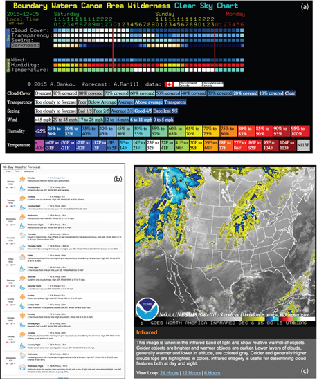
17.7
Short-term weather forecasts for nightscapers: (a) ClearDarkSky.com; (b) Ten-day forecast from Weather Underground; and (c) the sky quality forecast from NOAA.
Source: ClearDarkSky, WU, NOAA
both predictors are usually very reliable. ClearDarkSky is also available as a desktop tool and its value and uncanny accuracy to predict highly local conditions can’t be overstated.
Finally, the websites maintained by the NOAA of the U.S. government contain a wealth of data, including valuable information relating to cloud cover, Figure 17.7(c) and the possible presence of smoke from forest fires. These sites contain a wealth of up-to-date data, potential warnings, and can potentially save your life!
Planning—International Space Station
The International Space Station orbits the earth approximately every 1 ½ hours. In many locations, one or more of these orbits can place it overhead each day. There are several websites that predict its likely visibility for specific locations on Earth, including Heavens Above, Figure 17.8. This site also includes predictions for the visibility of a number of other satellites, as well as the potential to see the brief flash of reflected sunlight known as an “Iridium flare” from one of the remaining Iridium satellites.

17.8
Predictions for visible passes of the International Space Station for the 10-day period encompassing New Year’s Day, 2020, from the site operated by Heavens Above. Similar predictions from the same site are available for Iridium satellite flares, as well as passes of other known satellites.
Source: http://www.heavens-above.com
Planning—Roles of the Internet and Social Media
Finally, the Internet and social media keep us awash in constantly updated images and information from all corners of the world. I frequently search online for nightscape images of the Milky Way, star trails, and other possibilities from candidate destinations to gain a sense of what others may have been able to accomplish during the initial planning phases of an upcoming trip. I find work done by those before me both inspirational and motivating, confident in knowing that my own images from the same area will reflect my personal creative vision.
The World At Night (TWAN), Figure 1.2, is my go-to site for a tremendous wealth of extraordinary nightscape images made from diverse locations around the world. Many times I will view an image made far away from my location and imagine ways I could re-create it at home. Other times, when I am planning a trip abroad, or even choosing between possible destinations, TWAN will have example images made at the various candidate locations that will guide me one way or another. Finally, TWAN is searchable by topic and geographical location, making it very easy to explore.
Instagram, Flickr, Tumblr, Twitter, and Google+ have communities dedicated to rapidly sharing images, tips, and other information related to landscape astrophotography, both for enjoyment and constructive criticism. You might find it beneficial to explore and contribute to these communities as a way to develop a network of colleagues and to receive helpful feedback. Finally, Facebook has a number of groups dedicated to specific aspects of night photography. Such groups are very helpful in sharing information and useful tips on techniques, shooting locations, and times. Specific groups that I belong to include the Great Lakes Aurora Hunters, Sky at Night, The World At Night, and the International Dark-Sky Association.
Bibliography
http://djlorenz.github.io/astronomy/lp2006/
https://itunes.apple.com/us/app/theodolite/id339393884?mt=8