Finding your location on Google Maps
Locating and contacting businesses and services along your route
Using Google Maps to get driving directions
Avoiding traffic jams with the real-time traffic viewer
Using GMaps
Google has made its wonderful Google Maps and Keyhole Satellite data small enough to fit into your mobile phone or handheld device. You can get nearly the same functionality you would expect from your desktop or laptop computer right in your palm. Find locations, get directions, find businesses, and even see your friend’s car on the satellite image. Speaking of cars, you also can save yourself lots of time sitting in traffic by finding out ahead of time what the traffic looks like along your route.
Google Maps is currently available throughout much of North America and several countries in the European Union. Google is working hard to make this service available everywhere.
Google has created a mapping application for the Java program environment that runs on many mobile phones and wireless handheld devices. People have enjoyed using Google Maps on their desktop or laptop computers, and that same service is now available for the small displays typical of cell phones. As with most of Google’s services, this one also is free.
To begin using Google’s Mobile Maps, visit www.google.com/gmm from your mobile device’s Web browser. The Google Maps application begins installing automatically. After the installation is complete, you can access Google Maps by selecting it from your mobile device’s list of applications.
After Google Maps launches on your mobile device, you can click the right button on your device to select the menu. These options appear on-screen and are shown in Figure 27.1:
1 | Find Business |
2 | Find Location |
3 | Directions |
4 | Satellite View |
5 | Clear Map |
6 | Zoom |
7 | Help |
# | Show Traffic |
0 | Quit |
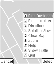
Select one of these Google Maps menu options by pressing the number or symbol on your mobile device keypad. The first three selections and Help launch a pop-up dialog box that assists you with these features. Choosing Satellite View, Clear Map, Zoom, and Show Traffic does not display a dialog box.
Note
This service does not currently work with Nextel, T-Mobile USA, or some Verizon phones. See www.google.com/gmm/devices.html for updates on supported wireless services.
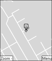
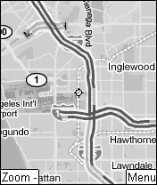
Before you can use most of the map features, you need to find a location on the map. First, find a location by pressing the number 2. Type an address, and a new map loads, displaying your destination. By default, your destination displays as a map, as shown in Figure 27.2.
Tip
If your display appears as a satellite image, your location is still noted but may be difficult to navigate. Select menu item 4 to toggle between Map view and Satellite view.
You can type your location in many different ways, as specific or as general as you like. For example, typing a ZIP code shows you a map centered in the middle of that ZIP code. Additionally, you can type a street address to see a specific home or business. Type a country name to view an entire country.
When you type the street address, you should include the city and state, or at least the ZIP code because there are many 123 Main Streets in the world. If you do type only 123 Main Street, then you must select the specific location from the list of locations by pressing the numbers 1 through 9 on your mobile device keypad. Only the first nine results can be displayed. So if you were looking for a location in Ohio, you would be disappointed because the first nine locations displayed in Google Maps for 123 Main Street are in the United Kingdom.
After you locate the address on the map, a balloon appears over the location with the address and the option to press the number 1 for options. These are your options:
Directions to here
Directions from here
Save as favorite
Select Directions to here to get driving directions from another location to this location. You are prompted to type the starting location. Select Directions from here to see directions from this point to another location. In this case, you are prompted for an end location. You can find more information about driving directions later in this chapter.
The third option is to save this location as one of your favorites. Favorite locations are saved for easy access later when you need the address to see a map or to see directions to or from your favorite location.
After your location is saved as a favorite, it changes color and appears with a star. You can press the * key on your mobile device at any time to view your favorites.
Sometimes, the balloon displayed on the map blocks important information. You can make the balloon disappear by pressing option 5 from the menu, Clear Map.
You can easily view a smaller portion of the map in finer detail (zoom in) and see great portions of the map in less detail (zoom out) by using the keys on your mobile device.
To zoom in and see maps in greater detail, press the center button on your phone or the equivalent of the center button on your mobile device. Zoom out using the soft key on your phone, or the left button beneath the word Zoom. A soft key is a key immediately below the cell phone display window, performing the function currently listed on the cell phone display screen.
Note
Zooming in too far eventually gives you an error telling you that no data is available. Zoom out to again view your map.
You can zoom in either Map view or Satellite view. Zooming in Satellite view allows you to spot landmarks that may help you find your way. When you zoom in or out, a rectangle appears momentarily on the map showing you the area you will see when the new map loads.
Drag the map using the up, down, right, and left arrow keys on your phone. This is a simple way to move around the map. Dragging the map—moving it north, south, east, and west—using the arrow keys is similar to grabbing it with a mouse on the computer-version of Google Maps.
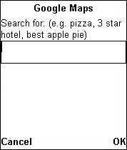
Need gas? Find gas stations or any other type of business by pressing 1 from the Google Maps menu. A pop-up appears that prompts you to type the category of service you are looking for in the next screen. You must press the right OK soft key to type the service in the text box, as shown in Figure 27.3.
A map appears that shows you the services you searched for, each appearing on the map marked with a small number. You can press the number of the marked location on your mobile device keypad to see information about the service, including its address and phone number. By default, the phone number is highlighted so you can press to call. Not having to dial the number is a great feature.
Tip
You probably should not use Google Maps while you drive. Use your navigator, co-pilot, or whatever you call the person in the passenger seat. If you are driving alone, pull over and use the service while parked.
From the information box, you can select from these choices:
Directions to here
Directions from here
Save as a favorite
Some of the pop-up boxes have Address and Details tabs. The Address tab contains the information normally displayed in the information box when no tabs are displayed. See the Details tab by pressing the right arrow on your mobile device; it toggles to the Address tab using the left arrow. The Details tab contains links to additional information, such as Citysearch.com, where you can view online city guide and Yellow Pages information. Additional information regarding the service may be displayed as text, rather than as a link. For example, for restaurants you may find the average meal price, and for coffee shops, you may see that Wi-Fi hotspots are available.
One of the best reasons for using online maps is to get driving directions from one location to another. Google Maps offers this same important feature in its mobile application. After bringing up the Google Maps menu, press 3 from the menu. In the pop-up that appears on your mobile device, type the address of the starting location. After you enter the starting address, another pop-up asks you for the end address. The route is traced, and Google Maps displays the following information:
Distance: In miles
Time: Driving time in days, hours, and minutes
Traffic delay: The typical delay you can expect when driving from your starting location to the end location
Press the number 3 on your device to begin viewing the directions. You also can choose to save this route in your favorites, which saves you from having to enter begin and end locations in the future. The driving directions appear as bullets above the map for each turn you will make. They are displayed one at a time so that you can read them easily on a small screen.
To return to the information screen or the previous directive, press 1 on your device. To advance to the next directive, press 3. You can continue pressing 3 until you finally arrive at your location.
One of the very cool things about Google Maps on your mobile device is the ability to check the real-time traffic delays along your route. From the Google Maps menu, select the last option or press # on your mobile phone keyboard. You also can select the Show Traffic menu option. The map changes to show the current traffic situation in the area you have mapped, using color coding. Of course, this works only on mobile devices with color displays. Otherwise, it looks like the image in Figure 27.4.
Traffic moving along at normal speeds is shown in green. When traffic is slowing, it appears in yellow. And when traffic on the road turns into a parking lot, roads appear in red on the map.
Tip
If you have previously mapped locations or services, the information boxes or balloons may hide the traffic information. You may want to press menu option 5, Clear Map, before selecting to view the traffic. Also, if you drive the same way every day, try saving your location as a favorite.
Google Maps does not have an alternate route selection, so you need to drag the map until you find your own alternate routes. Just a reminder: Don’t check Google Maps while you’re driving, particularly if you are also drinking coffee.
GMaps is a free third-party product found at www.mgmaps.com. It displays Google Maps as well as maps from other online map providers, as shown in Figure 27.5.
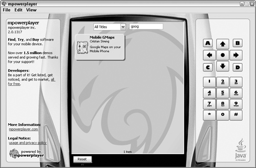
The GMaps product has support for Mobile WikiMapia, KML files (Keyhole Markup Language used by Google Earth—Keyhole is the name of the satellite that takes those great satellite images), subway maps for the world’s large metropolitan subway systems, and GPS tracking through Navizon and APRS systems.
To use GMaps, your mobile device must be Java J2ME-enabled. Of course, your device must also be Internet or WAP-enabled.
To download GMaps, point your mobile device Web browser to http://wap.mgmaps.com. Select the Download here link. After you install GMaps, you can begin using it to locate your current position and track your progress along the way.
Google Maps on a mobile device is a great timesaver and convenient way to locate businesses, get driving directions, or show your friends a satellite view of the hidden reef that has become your favorite secret surfing location. The interface is simple and not unlike Google Maps on the Web. Best of all, it’s free. Also free is the downloadable Tip Sheet from www.google.com/gmm/tip_sheet.pdf.
Google Maps is not the only service that Google has configured for mobile devices. Learn about many of your favorite Google applications squashed to fit on your mobile device in the next breathtaking chapter.