
Arc Length Example: Approximating Distances on Earth
One application of computing arc lengths on spherical surfaces is approximating distances between points on Earth. Sometimes these are called great-circle distances . Of course, the earth is not a perfect sphere but an ellipsoid slightly squatter from north to south than east to west. That is, if we were to orbit the earth along the prime meridian, we would find the distance traveled to be less than that of orbiting the earth along the equator. Still, treating the earth as a sphere usually gives reasonable approximations.
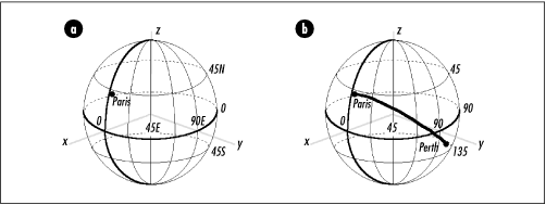
To compute the distance between two points on Earth, we first need a way to locate each point. In geography, points are usually located in terms of latitude and longitude . Latitudes sweep from at the equator to 90 degrees at either pole. For points north of the equator, the letter “N” is appended to the latitude, and for points south, an “S” is appended. Often, degrees north of the equator are thought of as positive and degrees south of the equator as negative. Longitudes sweep from at the prime meridian to 180 degrees in either direction. For points to the west of the prime meridian, the letter “W” is appended to the longitude, and for points to the east, an “E” is appended. Often, degrees west of the prime meridian are thought of as positive and degrees east of the prime meridian as negative. For example, Paris is approximately 49.010 degrees to the north of the equator and 2.548 degrees to the east of the prime meridian. Therefore, its position is 49.010N, 2.548E, or 49.010, -2.548 (see Figure 17.8a).
To approximate the distance between two points on Earth given their latitude and longitude, we first translate each point into spherical coordinates and convert all angles from degrees to radians. Then, we simply compute the length of the arc between the points. Recall that a point in spherical coordinates is given by the triple (r, θ, φ). In terms of the earth, r is the distance along an imaginary line from the earth’s center to a point on its surface; that is, r is the earth’s radius, which is 3440.065 nautical miles. The coordinate θ is the angle the point forms with the prime meridian. Thus, θ corresponds to longitude. However, since positive longitudes are to the west and positive values of θ are the opposite direction, to obtain θ from degrees longitude, we reverse the sign of the longitude. The coordinate φ is the angle a point forms with an imaginary line extending vertically from the center of the earth to the north pole. Thus, φ corresponds to latitude. However, since latitudes are relative to the equator and not the north pole, to obtain φ from degrees latitude, we reverse the sign of the latitude and add 90 degrees.
As an example, to compute the distance between Paris, France (49.010N, 2.548E) and Perth, Australia (31.940S, 115.967E), we begin by converting their latitudes and longitudes to spherical equivalents: (3440.065, 2.548, 40.990) for Paris and (3440.065, 115.967, 121.940) for Perth. Next, we convert the angles in each point to radians. Last, we compute the length of the arc between the points, which is 7706 nautical miles (see Figure 17.8b).
This example presents a function, geodist
(see Examples Example 17.5 and Example 17.6), that approximates the
distance between two points on Earth using the method just described.
The function accepts the latitude and longitude for each point as
lat1 and lon1,
and lat2 and
lon2. It returns the distance between the
points in d. After performing some initial
validation of the latitudes and longitudes,
geodist converts the latitude and longitude
representations into spherical coordinates, stores each representation
in p1 and p2
with all angles converted to radians, and calls
arclen to compute the distance.
The runtime complexity of geodist is O (1) because all of the steps in computing a great-circle distance run in a constant amount of time.
/*****************************************************************************
*                                                                            *
*  ------------------------------- geodist.h ------------------------------  *
*                                                                            *
*****************************************************************************/

#ifndef GEODIST_H
#define GEODIST_H

/*****************************************************************************
*                                                                            *
*  Define the radius of the earth in nautical miles.                         *
*                                                                            *
*****************************************************************************/

#define            EARTH_RADIUS          3440.065

/*****************************************************************************
*                                                                            *
*  --------------------------- Public Interface ---------------------------  *
*                                                                            *
*****************************************************************************/

int geodist(double lat1, double lon1, double lat2, double lon2, double *d);

#endif
/*****************************************************************************
*                                                                            *
*  ------------------------------- geodist.c ------------------------------  *
*                                                                            *
*****************************************************************************/

#include "geodist.h"
#include "geometry.h"

/*****************************************************************************
*                                                                            *
*  -------------------------------- geodist
                   -------------------------------  *
*                                                                            *
*****************************************************************************/

int geodist(double lat1, double lon1, double lat2, double lon2, double *d) {

SPoint             p1,
                   p2;

/*****************************************************************************
*                                                                            *
*  Validate the coordinates.                                                 *
*                                                                            *
*****************************************************************************/

if (lat1 <  -90.0 || lat1 >  90.0 || lat2 <  -90.0 || lat2 >  90.0)
   return -1;

if (lon1 < -180.0 || lon1 > 180.0 || lon2 < -180.0 || lon2 > 180.0)
   return -1;

/*****************************************************************************
*                                                                            *
*  Convert each latitude and longitude to spherical coordinates in radians   *
*  using the earth's radius for rho.                                         *
*                                                                            *
*****************************************************************************/

p1.rho = EARTH_RADIUS;
p1.theta = -1.0 * DEGTORAD(lon1);
p1.phi = (DEGTORAD(-1.0 * lat1)) + DEGTORAD(90.0);

p2.rho = EARTH_RADIUS;
p2.theta = -1.0 * DEGTORAD(lon2);
p2.phi = (DEGTORAD(-1.0 * lat2)) + DEGTORAD(90.0);

/*****************************************************************************
*                                                                            *
*  Compute the distance between the points.                                  *
*                                                                            *
*****************************************************************************/

arclen(p1, p2, d);

return 0;

}