With geographical data becoming ubiquitous in our digitally connected world, it is now a fairly simple task to use that data in our 3D-printing projects. Include color photos from satellite imagery, use a color-capable printer, and you have a useful scale representation of any corner of the globe.
Commercial grade printers capable of printing thousands of colors in three dimensions are an excellent option for not only terrain models, but also for scale architectural models and visualizing product prototypes. In this chapter, we'll dig right in to see how easy it is to 3D print terrain and multicolored models from SketchUp.
SketchUp and Google Earth are integrated together so nicely that it really couldn't be easier to import terrain data.
The following are the steps to get Google Earth terrain into SketchUp:
- First, open SketchUp. Navigate to File | Geo-Location | Add Location....
- A dialog box pops up as shown in the following screenshot. You may need to log in to your Google account to continue. Find the location you are interested in by entering an address, place name, or just navigating the map by panning and zooming:
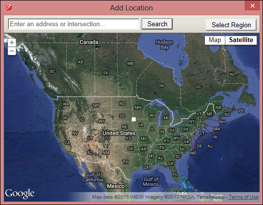
- Choose a location using the Select Region button on the top-right corner of the window. Use the four blue corner pins to fine-tune your selection. The maximum selection size is 2 km (1.2 mi), minimum is 10 m (33 ft).
- Click on the Grab button at the top-right corner of your screen to finish the selection process and import the terrain into SketchUp.
- You'll see a completely flat satellite image in SketchUp. The terrain is also there, but hidden on a separate layer that is turned off by default. To access it, open the Layers window (Window | Layers) and check the box next to Google Earth Terrain. You can turn off the satellite image by unchecking the box next to Google Earth Snapshot.
- You can see the terrain in 3D now, but it has no thickness. We'll have to add thickness and scale it down to make it 3D printable.
- The terrain is in a group, but you can't interact with it yet because it's locked. You can tell that it's locked because the group's bounding box is red instead of the usual blue color, and you can't open the group for editing. To unlock the group, simply right-click on the group and click on Unlock.
- All of the lines of the mesh forming the terrain are soft and smooth by default, making it difficult to work with the terrain. To see the lines, either turn on Hidden Geometry, as shown in the following screenshot, or unsoften the lines by selecting the group and moving the slider in the Soften Edges dialog box (Window | Soften Edges) all the way to the left:

- Now you need to add thickness to the model. This can be done manually by drawing lines down from each corner and connecting them to form a flat base. Instead, I suggest you use the extension Add Terrain Skirt (http://sketchucation.com/forums/viewtopic.php?p=359903#p359903) to complete the task in seconds. Use the Entity Info window to ensure the terrain group is Solid before continuing. The result of this step is shown in the following screenshot:

- Since the terrain is imported at full size, the last step is to scale it down for printing. Use the Tape Measure tool to scale your model down using the technique we discussed in Chapter 3, From 2D Drawing to 3D Model. Finally, check the thickness of the skirt to ensure that it meets your preferred printer's requirements. Export the model as
.stl, and you're ready to print!
This method is a good way to make a terrain model for printing on a desktop FFF printer because the flat base provides a support structure. However, for an industrial printer, you'll want to hollow out the base to use less material. An easy way to do this is with the JointPushPull Interactive extension (http://sketchucation.com/forums/viewtopic.php?p=496773).
JointPushPull can take a collection of connected surfaces and add a precise thickness to them. In our case, we want to keep the skirt walls, but remove most of the mass. To do this, make a copy of the solid terrain model for your historical timeline, then delete the bottom face, as shown in the following screenshot:

Select all, then use the right-click menu and go to JointPushPull | Joint Push Pull. Using the default options, make the terrain and walls 2 mm thick. If you encounter an error, scale the model up by 100 times and then run the operation. You may have to fix some small errors to make the model solid again. In this case, hollowing the model reduced the print material required by 85 percent.
Note
Google Earth is one source for terrain data, but the quality is low in many places, especially remote locations. There are many more ways to get terrain models including survey data and free online resources. SketchUp Make and SketchUp Pro import .dem files, which is a common format for terrain data.
Since .stl files do not store color data, so far this model can only be printed in a single color. For printing the satellite imagery in color, we need to do some more work on the model.