Conservation of historic earth buildings
Abstract:
The first part of the chapter outlines the initial analysis and study of the earth-walled city of Diriyah in the Atturaif region of Saudi Arabia. It discusses what lessons can be learnt from this example, including the different climatic issues and the importance of site maintenance. The second part of the chapter discusses the restoration of ‘Casa Patacca’ in the Abruzzo region of Italy.
16.1 Introduction
Historic cities need to be able to adapt to modern living if they are to continue to flourish and grow. If they do not adapt the cities can start to stagnate, becoming run down, eventually leading to disuse. Therefore the restoration of historic buildings is often necessary to keep them in a usable condition, even though this can sometimes conflict with the main aim of heritage preservation.
The subject of authenticity is often brought up when discussing conservation of heritage. This is because authenticity is considered to be the way in which historic buildings and artefacts can be ‘valued’. In the Atturaif region, the authenticity of the buildings is expressed in their architectural form and function, the materials adopted and the techniques used to build them, as well as through the site where the buildings are placed.
As an example of how contentious authenticity can be, consider the problem of sacrificial layers. These are solid layers of soil that are applied to the base of the walls of earth buildings to protect them from being affected by moisture uptake. These layers require continuous maintenance. The question that is often raised is will the building still be authentic after the new sacrificial layers are added to protect the original layers below? And furthermore, will the building still be authentic after it is restored and replastered? Earth buildings require periodic maintenance, as well as new renders and sacrificial layers. The World Heritage Committee has recognised this. One opinion is that the authenticity of a historical building lies in the specific techniques used to create and maintain it, and not exclusively in the materials themselves.
Parts of the city of Diriyah are to be restored and adapted in order to be used to house museum structures. An example of how authenticity can be preserved is through the use of new modern reversible buildings on pad footings, which are designed to be inserted inside the restored ruins. Thus the historical buildings can be both preserved and utilised.
16.2 Common causes of deterioration on historic earth buildings
Often, the greatest threat to an earth building is moisture and poor site drainage conditions. Moisture that accumulates at the base of walls migrates through the walls through capillary action, causing the earth to lose cohesion, subsequently weakening the wall. Continued exposure to moisture can degrade the internal structure of the earth wall by allowing the clays to expand. Moisture that is channelled into the base of the earth walls through poor site conditions can begin to undercut the wall through mechanical erosion, causing the structure to collapse in the long term.
Another threat is rainwater, which is often directed onto the wall where there is poor roof protection and drainage. Snow is also a great threat, as it accumulates at the base of the buildings, keeping that section of the wall permanently wet, which can, over time, cause the loss of the entire wall.
Other significant threats are caused by human and animal activities. Human activities can cause differential decay of the walls. This is often caused by poor building practices and systems that are incompatible with the existing systems. Vibrations from motor vehicles and excavations can also cause numerous problems if there is not appropriate site management in place. Animal activities, such as the nesting of insects and other animals, microgrowths, rodents boring galleries and livestock brushing the base of the walls, can all cause direct and indirect damage the earth structures.
16.2.1 Erosion mechanisms
Water is the greatest enemy of an earth building. With persistent dampness the walls move and pass from a solid state to an elastic one. Because the water is prevented from moving and evaporating from the wall, it causes condensation on the cold surface. This can in turn cause serious deterioration that in most cases is not directly visible from the outside. It is only noticeable once the majority of the wall has severely deteriorated. Owners of earth structures often cover the base of walls with cement render in order to make the wall more resistant to water penetration; however, this can cause much more severe erosion over time.
Standing water can be caused by placing objects against walls, plants that need to be watered, and also by earth falling towards the wall base. This water is then subsequently absorbed and transmitted into the wall through capillary action. The base course and the top of the wall require continuous maintenance in order to fight erosion.
16.2.2 Structural defects
Structural defects can be caused by a number of things. Initially, defects may appear as a minor crack in the wall, but in the long term defects can lead to the collapse of the entire wall. The major causes are unsuitable soils used as construction materials, poor construction techniques and unsuitable damp protection. The use of soil as a building material requires good practice, respect of building codes and systems to be in place from the very beginning, to the completion, of the structure. Structural defects can lead to structural cracking, by which point the earth wall is no longer resistant to stress. Structural defects can also be triggered by vertical shrinkage cracks caused by carelessness in quality control of the earth used for construction. The sourcing of suitable materials is of equal important for repair and reconstruction of heritage earth walls, where an optimum balance of sand and clay is necessary. This can be attained through analysis of the material in a laboratory before construction begins.
Another cause of structural defects is poor site choice, for example, areas where water pools or where the building may be exposed to strong winds or natural disasters.
16.2.3 Water study and protection principles
The cycle of wetting and drying with the movement of salts in the building material can cause severe erosion at the base of the wall when the cohesion of the earth particles is compromised. Sealing the perimeter of the building with a cement footpath, with the intention of protecting the wall base, will only increase the causes of erosion. It is important for water to be able to evaporate from the walls, as it will move through the foundations in the wall and through the base coure where it will evaporate, causing exfoliation of the layers on the wall surface. The base of the wall is highly vulnerable to water damage and for that reason it is an area that requires constant scheduled maintenance and attention.
A rise in ground level can also cause several problems. Activities such as excavation for pipe work, road maintenance and waterproof footpaths all diminish the height of the base course of the wall, therefore adding to the exposure of the wall base to moisture. The basic technique of adding a wearing layer over the base course is dependent on the continuous repristination of the layer itself over time. The idea being that this layer of soil will be affected by moisture erosion before the base course.
The height of the base course, commonly made of brick, stone or concrete, is also of primary importance in protecting against erosion. It needs to be adequate to handle the wet season, as well as water carried by strong winds. Of fundamental importance is the provision of a waterproof membrane, which is laid over the base course of the earth wall to stop water rising through capillary action throughout the wall surface. Moisture barriers offer great protection against water in both stabilised and unstabilised walls. They can be laid vertically to both the exterior and interior surfaces of the wall or together horizontally above the base course, therefore stopping the capillary action of water movement, although they must be uninterrupted for this to work effectively. Moisture barriers can be made out of bituminous products or water-repellent cements. Chemical binders are also commonly used amongst earth builders. The danger in using these products is that, although they have been tested, they have only recently been introduced to the market, therefore their performance over the coming years is not guaranteed. New water-repellent additives can waterproof walls throughout, thus makinge earth walls more suitable for very exposed conditions, including retaining walls. However these additives may inhibit the breathability of the material. All water, no matter how small the quantity, needs to be able to evaporate from the walls and these additives, if not used in moderation, might cause more harm than good. Care should be taken with regards to choice of waterproofing in order to avoid adding toxicity to the surfaces of the walls, and consequently movement of toxic particles throughout the building.
It is important that all protection principles are used together with the correct site maintenance programme. The effectiveness of a site maintenance programme is often dependent upon the scheduling of the maintenance activities themselves. Activities such as cleaning gutters and downspouts and removing accumulated debris and objects at the base of the walls are all part of a good preservation maintenance programme.
16.3 Conservation of earth architecture
Earthen sites make up 10% of the World Heritage List of UNESCO. Many of these sites are currently under threat. Modern earth construction has seen a consistent increase in the industrialisation and standardisation of the industry, whereas the conservation of earth architecture has unfortunately undergone much slower progress. However, over the past 40 years, the field of conservation has received some much-needed interest, with a sequence of international conferences aimed exclusively at earth conservation that were started in Iran in 1972. Another wave of interest was caused by a series of educational activities known as the PAT courses or Pan-American Courses on the ‘Conservation and Management of Earthen Architectural and Archaeological Heritage’ offered from 1989 to 1999. A series of workshops, seminars and courses throughout the world have also advanced the field of study and the conservation of earthen architecture. The reality is that earthen architecture is finally being recognised as part of our heritage. The conferences made one thing clear: it is impossible to reduce conservation to a ‘treatment’ that is simply aimed at stabilising or consolidating a surface. Conservation is also about education, research, public awareness and professional practice. In 1983 the international symposium held in Peru on earthen architecture reiterated the need for education; however, it was not until 1987 that the International Centre for Earth Construction – School of Architecture of Grenoble (CRATerre-EAG) assumed responsibility for such programmes. In 1989 the International Centre for the Study of the Preservation and Restoration of Cultural Property (ICCROM) began to share the responsibility for educational programmes. The Gaia Project came from the 1989 agreement between CRATerre-EAG and ICCROM on educational programmes, which stressed the importance of on-site education. Later came Project Terra, another agreement of collaboration, between the Getty Conservation Institute GCI, CRATerre-EAG and ICCROM. In May 2004, the GCI participated in ‘Unfired Clay Construction in Italy: Toward a National Building Standard’, an event organised by Citta’ dell Terra Cruda with support from UNESCO (Italian Commission) and other Italian institutions working towards development of a national standard for earthen architecture.
Earth architecture is the oldest and most widespread architectural expression of our monumental heritage, for this reason its conservation is a priority. There is a growing interest in preserving our cultural heritage, hence the plethora of international courses and workshops on the subject. As architectural acculturation becomes more acute, innovative ways of conserving earthen architecture will need to be found.
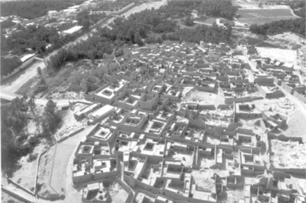
16.4 Case study of the UNESCO heritage site of Diriyah in the Atturaif region of Saudi Arabia
This section discusses the evaluation of the archaeological site of Diriyah, its historical evolution, the physical fabrication of the buildings and the social environment in which the site developed.
16.4.1 Analysis
The cultural significance of the site was assessed in terms of aesthetic, social and scientific significance. Whilst examining the collapsed walls of the city of Diriyah, it was found that the collapse was not directly due to the failure of the foundations, as the city was built on a rocky basement of limestone which came to the surface in some points. The collapse was caused by erosion; the product of salts crystallising at the wall base above the limestone stem wall and the separation between material layers, causing further severe erosion. The introduction of service infrastructure along the curved roads, coupled with poor site management, meant that the excavated earth and walls collapsed on one side, directing water to pool in several other areas and channelling it through the standing walls towards detached areas. This caused severe erosion to numerous buildings that subsequently required propping. This demonstrates that even local site work that can appear insignificant can be disastrous when coupled with a large amount of rainfall and bad site management.
16.4.2 The earth city of Riyadh and the first Saudi state
During the second half of the 18th century, through to the first quarter of the 19th century, the Atturaif region became the centre of the first Saudi state. The development of this area expanded across the seasonal river Wadi Hannifah, from the existing Addiriyah quarters, with the construction of an administrative centre, a treasury and the palaces of the Saudi Princes. Saud Bin Muhammad took over as chief of Addiriyah in 1720 and became the founder of the House of Saud. His son was responsible for the establishment of the centre of the first Saudi state in Atturaif. In 1818, and again in 1824, the Ottoman Empire destroyed the site. Afterwards, the people who had resettled in Atturaif and reconstructed some buildings resettled in Riyadh. Following this event, the House of Saud was relocated to the city of Riyadh and the earth city was left to decay, neglected for over 125 years.
In the mid-20th century some 200 families resettled in the east part of the site, building new houses on the debris and ruins of the first Saudi state. The destruction of the site and years of total neglect took a heavy toll on the site. The reoccupation of the site itself meant the removal of several structures and detrimentally affected the integrity of others (Crosby, 2007). Today, this historical area is considered to be an important part of the metropolitan area of Arriyadh. People from all over the country can come to visit the home of their forebears and it is planned to become a major tourist attraction once it has been stabilised and restored.
16.4.3 Climatic conditions in the Najd region
The Najd region in Saudi Arabia has a long, hot and almost dry summer with large diurnal temperature differences. Winter is almost non-existent, and it rains for a total of one month per year. The reason for this is that the air masses are exhausted before they reach the internal areas. The high mountains also create an almost impenetrable wall that the rain clouds cannot easily pass over. During the day there is intensive solar radiation and at the night a rapid cooling occurs under the cloudless sky. The maximum air temperatures range between 30 and 46°C in the months of June, July and August in the city of Riyadh. The highest temperature during the day is about two hours after midday. Rainfall follows irregular patterns and is very minimal, the yearly average being around 100 mm. Although total rainfall is low, when it rains, it comes in very large quantities all at once. This kind of intense rain is an obvious enemy of earth buildings, as it causes severe erosion and runoff. The rainfall is so intense that even the modern buildings now built in the city centre cannot withstand the rain and occasionally leak. This is also due to the enormous amount of sand and dust that continuously accumulates in gutters and downpipes – if these building elements are not part of a continuous maintenance programme they will be obstructed when the rainfall comes and will not work efficiently.
Due to these climatic conditions, with the sky virtually cloudless, the solar radiation reaches the ground very quickly resulting in very high temperatures. The winds are charged with dust as a consequence of the temperature contrasts between day and night. The winds from the north-east carry dust and debris due to the absence of vegetation and sand instability. This also is not good news for earth buildings as sand storms accelerate the erosion of the buildings, hitting the delicate earth plasters at enormous speeds.
16.4.4 Architectural and planning features
Diriyah is located approximately 20 m above Wadi Hanifah, the seasonal river; the site was strategically chosen and achieves what we would call today a sustainable climatic environment. The wadi is the corridor of the seasonal river. It is dry most of the time, with an occasional water stream that becomes a fast-flowing river once the rainy season brings a substantial volume of water. With its fertile soil the wadi was a perfect location to build a settlement.
The site choice and the climate are strongly linked. The walled city of Diriyah is located on the top of a hill; an area not suitable for farming. It is surrounded by palm trees and athel trees, an evergreen tree that can grow up to 18 m tall, commonly found along watercourses in arid areas. The prevailing wind direction is north-north-west. The site has an intimate relationship with the surrounding vegetation and the climatic conditions discussed previously. One interesting aspect of this is that when the hot, dry air starts blowing through the vegetation of the palm trees and the athel trees, the humidity content of the prevailing wind increases, and this in turn leads to a decrease in temperature. By the time the wind enters the buildings through the windows and ventilation holes, it has lost most of the dust and has also cooled by a few degrees. Because the site is around 600 m above sea level, it is not affected by large dust particles as it would be if located lower, near to the seasonal river. If the wind passed over a nearby river or lake before reaching the buildings, the reduction in temperature would be further amplified.
Vegetation is of high importance, not only in the natural air conditioning process, but also due to its ability to reduce the dust and lower the wind speed, which are both great forces which can cause erosion of earth buildings.
16.4.5 Settlement patterns
The compact layout of the site, in a fortified cluster of settlements, works strongly with the single units when analysed with regard to heat gain, street orientation, grid pattern and architectural features. In terms of layout, most of the dwellings have up to three walls in common, this strategy allows for minimal heat gain, as well as loss, through the external walls. The orientation of the streets is another important factor, as it minimises the amount of radiation from the sun that the buildings receive during the day. There are lots of continuously shaded areas all throughout the day, as the main pattern of the site is in the form of a grid, diagonal from east to west. The air in these shaded areas is a few degrees cooler than the surrounding environment, and it cools the surrounding dwellings when it penetrates through the triangular ventilation holes as well as through the windows. Because the streets are so winding and narrow, the wind velocity drops a little, thus reducing the severity of the erosion caused by the wind itself.
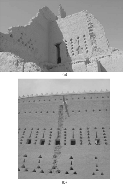
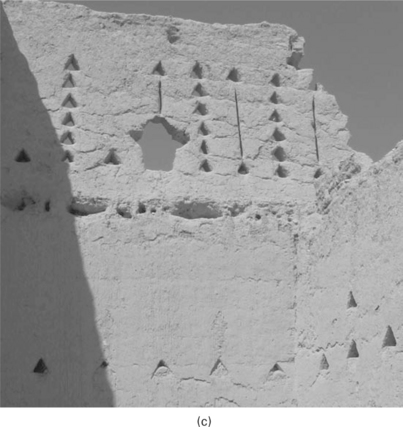
A characteristic of the western section of the site is differential weathering. It is easily noticeable how numerous walls have extensive weathering on their east face, where over half of the entire wall has been eroded away in contrast to the west face. Stone masonry was often used for this more aggressive orientation, where stones in herringbone patterns can still be seen as the sacrificial layers have been eroded away from them.
16.4.6 Dwellings and climatic factors
The Islamic style house is introverted, with most rooms lacking a specific function so that their use can be changed according to family components and necessity. Intrusion of the outside world seems to have been discouraged in this settlement, with women only observing public life from behind the screens or through very small windows of up to 600 600 mm. The percentage of openings on the façade ranges up to a maximum of 10% of the total façade area. An important element of these buildings is the high location of the windows for privacy from the street. This is also to allow warm air to escape and reduce dust infiltration. White lime render is used around the openings of the windows to reflect as much heat as possible before it enters the building. Green planted courtyards, possibly used in conjunction with a pool of water, can be invaluable for cooling. The courtyard was seen as the heart of these traditional buildings, moderating the climatic extremes. They are normally square or rectangular in shape, a traditional response to the harsh environment, supplying light to the verted rooms surrounding it. The air circulates through a continuous breeze via a natural convection current created by the courtyard. At night, the courtyard behaves like a sink of fresh air, attracting the cool air down from the roofs (sleeping areas), whilst during daytime, as the sun heats up the courtyard, the air temperature rises, acting as a thermal chimney setting up a breeze from outdoors into the courtyard. Because the courtyard is located at the heart of the building, not facing the prevailing wind, it works in creating a low pressure so that when the wind passes, it initiates a continuous breeze throughout the day. The bigger the ventilation holes on the building opposite to the direction of the prevailing winds, the stronger the breeze that is created.
The location of the courtyard and its proportionate size with regards to the size of the dwelling appears to have come from centuries of experimentation. The courtyard easily modifies the microclimate of the dwelling, reducing temperatures and increasing comfort for its inhabitants, insulating them from dust and noise. Shading elements were also used in the courtyards, when there were few or no trees present, the colonnades would shade the walls themselves. Remnants of cooking tools have also been found in the courtyards, from which we can infer that cooking was carried out outdoors, at least in the hot season. Here, the urban unit can be described as a cluster, with each cluster composed of a series of dwellings. There are random divisions between each cluster some of which are wider semi-private streets.
16.4.7 Materials, construction methods and building components
The athel tree was often used as a building material on the site of Dariyah. Waterspouts were made from athel trees, and they were also used as floor beams covered with palm branches, palm leaves and finally compressed with soil to create a watertight layer. The end of the beams in each room would sit on a stone layer embedded in the wall, as this would facilitate the weight distribution to the adobe brick wall.
The beams were often chosen to have a bend, when the beam was laid horizontally forming a floor joist. The bend would face upwards in contrast to the weight. Such beams would then be intensively decorated with brightly coloured and simple geometrical motifs, as well as the doors the windows and the window shutters, by the women of the family. Each decoration would identify a particular family; no two were ever the same.
Adobe bricks made of earth were the main building material used in Diriyah, along with earth mortar and earth plaster. These adobe bricks were made by pre-mixing earth, water and straw, then compacting these elements in a mould. Straw was generally added to improve the tensile strength, acting as a three-dimensional rebar in the single adobe brick and reinforcing the entire structure when the building was finished. Clay binds all the elements of the brick together and was easily available from the wadi river. Bricks measured on site ranged from 16–25 cm with a height between 9 and 12 cm. External walls ranged between 40 and 50 cm while the internal walls ranged from 30–40 cm. The outer walls in most of the walls still standing have been tapered towards the interior to improve stability. It is curious that of the buildings still standing today, the toilet structures called long drop privies still survive while the rest of the building is in ruin. These wet areas of the buildings stand like skyscrapers and tapering of the wall is clearly visible from a distance as these structures reach over 15 m in height.
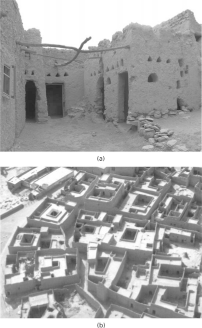
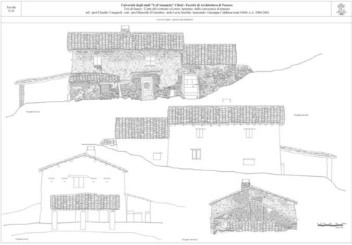
16.3 (a) and (b) Examples of how the buildings share common walls between them, with a courtyard (often shaded) used for lighting the rooms, keeping animals and plants, for cooking and as a circulation
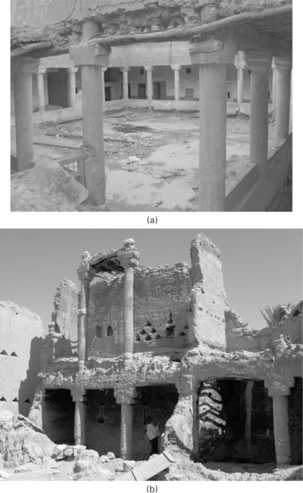
The adobe bricks were not directly laid on the ground but were separated by a strip stone foundation. No other foundations were present, as the site sits over pure limestone. Limestone drums, joined with earth mortar, were used to create columns. The drums had a height and diameter of 25 cm with a coarse external finish and render applied. The capital was created using two larger stones, over which a wood beam would then be placed to distribute the weight over each column.
16.4.8 Site erosion
The most visible erosion to this site has been caused by basal erosion. Every rainfall is severe, and it causes water to be rapidly channelled at the base of the earth wall, especially just above the limestone base stem wall. This initiates a movement of salt crystals throughout the wall, which causes erosion and undercuts just above the stone base. Many of the tall walls are still standing on site. They are reasonably stable in the lower sections but not so much in the higher sections.
16.4.9 Future outlook
Unfortunately, most of the population of the modern city of Diriyah do not have a good knowledge of building with earth. Some of the buildings in the city centre have shapes and forms of the old earth buildings, but these are generally made of concrete panels, resulting in a false architecture with no relationship to the surrounding environment or the people. Many of the shops in the city centre have an interior paint that is made of mud and straw over the fired brick or concrete walls, rather than ordinary painted interiors. This shows they do still have an association with the past. Modern architecture, just like the architecture of the past, must respond to the climate and site, utilising science and technology in order to find a solution to the major issues of our environment, and of global warming. Modern architecture should not only concentrate on façades, but should make the entire building work with its surroundings. By understanding the environment and by fully comprehending the traditional design criteria and methods, new solutions can be found.
Innovative solutions today will be regarded in years to come as ‘traditional’. Some of the elements from the historic architecture that are still in use today are tree planting, which can help to maximise shade and microclimatic effects with high and low-pressure zones, as well as reduce the intensity of sunlight whilst reducing the heat reflection of uncovered ground; narrow and winding streets; no asphalting or dark coloured surfaces to minimise heat radiation; grid pattern in relation to sun orientation; minimum presence of external openings; green and water elements working in combination; buildings in clusters with compact planning, the use of courtyards with a ratio of 1:1 up to 1:3 compared with the main building creating external spaces used as circulation areas; and finally, use of pergolas, light roofs and tent structures to create shaded courtyard areas adequate for recreation.
16.5 Case study of earth buildings in Italy: Loreto Aprutino in the Abruzzo region
The houses analysed in this case study are in the Abruzzo region of central Italy, in the town of Loreto Aprutino, in the province of Pescara. Buildings have been studied, analysed and catalogued. One building of major significance, with a kitchen and stalls at ground floor for the animals, and bedrooms above grouped around a central fireplace and staircase, was chosen as the main subject of restoration and study for a degree thesis in architecture. The technique commonly used in the area is that of the massone, an irregular block made of earth and straw in the shape of a bread loaf, which is stacked in a herringbone pattern in this locality.
16.5 An example of the tables that were used to record information for each earth building, including a detailed list of elements that characterised it, aerial photographs of the location on maps of different scales and an axonometric sketch analysis.
16.5.1 The Patacca house
Once the home of a peasant, the Patacca house now corresponds to modern living standards. Some parts of the restoration project of this building were started during the thesis stage, with the rest being completed later by the owners. In the 1970s, as a new oversized concrete building had been built just a few metres from it, the Patacca house began to be used for storage. Once routine maintenance of the house was halted, several issues arose. In the 1990s the deep excavation of a road bank metres from the main façade created a discontinuity in the equilibrium of the underground water table, which took its toll on the stability of the structure itself.
An earth building is constantly linked with its surroundings. If something changes in the surrounding area, this can create varying levels of readaptation of the structure, more often for the worse. Over the years, incorrect maintenance of the Patacca house had seen placement of cement render over the stone base up to the level of the first block courses, creating a waterproof seal that resulted in more detrimental issues.
16.6 This is an example of an earth building that has been consolidated using concrete. The base of the building has rejected the concrete, and it in turn has rotated away from the earth wall. This is caused by severe erosion due to trapped moisture below the concrete itself.
Cement renders and earth blocks have different thermal expansion coefficients, which can sometimes result in cracks forming along the façade, often leading to accelerated erosion. By cladding the building in concrete with a view to making it more resistant to water, rather than taking the approach of keeping the water away from the building via good site maintenance, more rather than less erosion was caused.
16.5.2 Field recording
The methodology of this recording was to conduct an initial survey of several undocumented country sites on the outskirts of the town of Loreto Aprutino, Pescara, Italy. Samples of earth from walls, together with plasters, were collected, analysed and displayed.
The first approach to analyse the buildings was through photography. All photos were taken with a scale of 30 cm, clearly identifiable at any distance. The scale was of fundamental importance as it allowed further analysis and comparisons at later stage. A dismountable framing timber square representing 1 m2 was hung on every side of the buildings, and photographs were taken perpendicular to the surface in order to be able to compare the fabrics. Photographs were especially taken of areas where there was a change in material, where the plaster was eroded or where the size of the bricks changed from the average size of the rest of the façade. The timber square also had intervals of 10 cm clearly indicated on each side. This method allowed comparison of construction methods in the subject building, as well as between distant buildings and ones where fired bricks were used.
During the field recording sessions, several people working in the fields where the buildings were located were interviewed. The buildings were for the most part built after the Second World War and were now seen by their children and themselves as a symbol of poverty associated with very difficult times; certainly not an image of progress. Many buildings still standing today are being gradually replaced in their exact location by a modern concrete building. This is because this is classed as an alteration or an addition to the existing building, rather than a new construction, which would mean some taxes payable to the Council can be saved. This strategy is becoming more and more common in Italy, as people are trying to save money.
After the Second World War, earthen building techniques were seen as a symbol of poverty. Following this period, there was a loss of interest in the know-how of earth building and therefore techniques were not passed onto the following generation. Common labourers need to be reacquainted with the construction methods but do not want to invest energy in a process they see as outdated and with almost no interest from the consumer. Today, thanks to a renewed interest during the 1980s, authorities are starting to recognise the importance of this heritage. Buildings are starting to be scheduled and recorded, including their construction methods and parts studied.
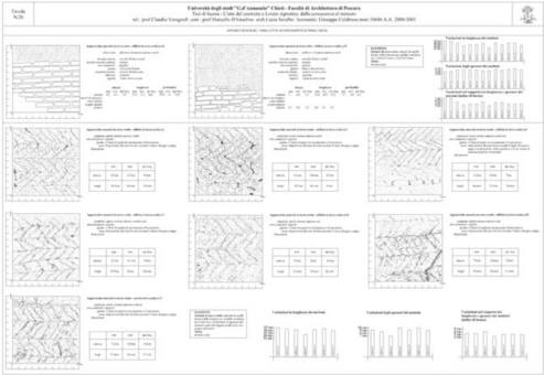
16.7 This table shows how m2 from every wall orientation of the buildings was recorded. Both the brick and mortar dimensions were recorded. This analysis showed which areas of the building were most eroded, it was then used by the builders during construction to protect the surfaces that were known to be more exposed.
16.5.3 Condition documentation
All conservation action must begin through scientific studies and a thorough understanding of the problems involved. Graphic symbols and pre-established descriptive terminology have been employed to aid recording methods, leading to a better understanding of each site. Prior to field recording, aerial photographs were collected by the state library, as well as maps of the territory at various scales. This allowed each building to be located in its context. Unfortunately historical photographs were never available for any of the buildings.
Once on site a ‘cartone di rilievo’ was produced and dated. This is a sketch of the building, in plan and elevations, recording as much information as possible during the first visit to site. As well as beam orientation, north point orientation, room space, surface finish, prevailing wind directions, repairs, overlays and any major erosion was recorded.
A range of graphic symbols was utilised to describe the building conditions as illustrated in Fig. 16.9. Each graphic symbol corresponds to a breakdown of the conditions and variables which allows correlation amongst those of the various buildings. Some variables recorded were the proximity to a road, number of buildings, presence of a fireplace, state of preservation, construction technique, levels, type of roofing and presence of foundations. These records allow us to postulate correlation amongst the buildings and further understand the cause and effect relationships through this initial reading of the physical evidence.
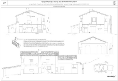
16.9 An example of how CAD was used to create accurate representations of the buildings and the earth around them.
In order to define classes of condition and layers of materials applied to the surfaces of the buildings, graphic recording systems were developed in both linear and overall pattern symbols. No colour was used for ease of reproduction.
16.5.4 Digital documentation
All façades were photographed in sections and information was put together and scanned.
16.8 This figure shows the way in which the buildings were recorded graphically, using symbols to differentiate different aspects of the buildings.
After thorough measurements of the façades, the field recorded information was imported into both photographic and drawing computer applications to transfer the field information into practical drawings. Several trips back to site were necessary as this type of building is never rectilinear, and one cannot assume a straight line between two points as all elements have moved and settled over time; the building itself as well as the ground. Following each rain season minor discrepancies could be detected in the measurements due to the movement of the various parts, and so it was decided to measure each building every few days and to transfer all the information to the computer immediately. The end product is a series of plans, sections and elevations with layers of information.
16.5.5 Types of building
In his investigations, Baldacci divides the earth buildings in Italy into three functional types: the farmer’s, the labourer’s and the craftsman’s house. The type of building has evolved as a consequence of its function. The functional demand in an area has therefore initiated a certain typology (Baldacci, 1958).
16.5.6 Structural instability
Structural instability is certainly the most serious of all the conditions affecting a historical building, as it can result in a sudden loss of all the fabric. Of the various buildings studied, structural instability was a major concern in all structures. Often the structural condition is the result of a number of variables; previous vandalism, environmental exposure, wall material, construction methodologies or subsequent stabilisation and incorrect maintenance interventions over time. It is often a combination of these factors that creates a range of conditions that we refer to as structural instability. Earthquakes and water table subsidence appear to have been the major causes of structural instability in the buildings analysed here. It has been found that seismic activity remains a major threat to loss of the building fabric.
16.5.7 Orientation and exposure
In the buildings analysed, it was impossible to establish to what degree the deterioration was caused by orientation, exposure or incorrect maintenance over time. The walls that appeared to be particularly vulnerable were those that were exposed to the prevailing winds. In several cases these had been covered with plastic sheeting by the owners, which can create a cycle of condensation and deterioration of the building behind the plastic film.
Where the wind has a higher speed it is inevitable there will be a higher level of deterioration. This was recorded along the eaves of the buildings, where the plaster had been totally eroded away over the years. Vegetation had also contributed to the decay of the buildings, creating stresses and differences in temperature along the walls through overshadowing and prevention of proper evaporation of the water trapped around the building after heavy rainfall. Also, drifting snow was seen to be collecting and melting at the wall base, which can cause further erosion. It was decided to remove the trees and their roots, which had entered the buildings, foundations contributing further to the erosion and loss of fabric.
16.5.8 Appropriate repair methodologies: plaster stabilisation
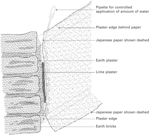
In the case of the earth buildings in Italy, a mechanical cleaning and removal of debris was necessary using small compressed air pumps and picks. Some areas were stabilised by spraying Japanese tissue facing paper, which was found to be very efficient. This system of rehydration was found to be the best system as it did not introduce any foreign materials to the walls, relying on the clays to re-establish lost cohesion. The areas that were removed and dampened were then reset into their initial location using the Japanese tissue paper and applying some light pressure via cosmetic sponges. Some areas were treated by injection grouting, as the detachment of the plaster from the substrate was major. These areas were initially flushed with a 3:1 water and alcohol solution. Soil and water were mixed prior to use. The mix was determined for each application on the site and approved only after test panels were employed. The area of plaster to be stabilised was sprayed using a gentle mist. The Japanese paper was gently positioned over the section of plaster. A pipette was used so that only a small amount of water would reach the paper and not the wall directly. In this way the water that soaked through the Japanese paper pulled the paper towards the surface of the plaster creating a bandage effect. The Japanese paper with the section of plaster was then lightly pressed against the rest of the wall. Once the area had cured and the paper totally dried, the Japanese paper was removed. All cracks were then sprayed damp and mortar compatible with the existing plaster was inserted via a syringe.
16.5.9 Restoration
The first intervention was to remove the concrete sealing of the ground around most of the building, which was trapping water below ground and moving it from the foundations to the stem walls. It was also decided to remove all trees around the building, to be replaced later, after a careful solar study and analysis of the prevailing winds to find out what effect these would have on the vegetation. Inside, at ground floor, the terracotta tiles had been laid directly on the bare earth. It was decided to remove the tiles and introduce insulating materials and vents, so that any trapped humidity could escape. Along the eroded surfaces of the wall, small grids made of olive wood were hooked to the wall in order to make it more compact, facilitating a connection between the existing and the new wall layer. Several tests were carried out in order to study the effects of the various plasters and mixtures before final application to the surface of the wall.
16.6 Conclusions
One of the major goals of the projects described here was to understand the earth buildings as much as possible before any intervention. The variables of each earth building are greatly dependent on location, which means there isn’t a common solution that can be applied worldwide, in every climate and for all wall compositions, orientations and exposures. The subsequent stabilisation and maintenance interventions are all different.
It is hoped that the research discussed in this paper will be of some value and assistance for the restoration of earth buildings worldwide, and that this understanding will allow for more effective preservation strategies in the future. There is a need for more funding to maintain buildings and ruins alike, and in order to allow a cost-effective use of those funds, prioritising work is imperative. Historic sites and cities need be adaptable in order to survive; to conserve them is to continue using them, otherwise they will be condemned to be seen only as an exhibit from another era.
The key point is to learn from climatic regionalism; in this case the use of wind towers, ventilation holes, chimneys and courtyards to work with the local environment. Indigenous or traditional building styles often use climate responsive designs and are appropriate in relation to other environmental factors, such as weather and natural hazards. Regrettably, architecture in our age has become increasingly mechanised, and earth is very rarely used as a resource for sustainable housing projects.
On the fringes of environmental issues, a range of disciplines, in research and practice, associated with earth building have re-emerged in the modern era. Earth is a 100% eco-friendly building material, which doesn’t require manufacturing or transporting. Earth is non-toxic, non-polluting and it ‘breathes’. Clays within the earth soils are hydroscopic, releasing and absorbing moisture in response to changing local atmospheric conditions, improving air quality, removing asthma triggers and reducing other respiratory diseases – this alone is an important factor to be considered when promoting and re-launching earth structures as a viable option for today’s living.
16.7 Sources of further information
Facey, W. Back to Earth, Adobe Building in Saudi Arabia. Saudi Arabia: Al-turaif, Riyadh; 1997.
Houben, H., Guillaud, H., Earth Construction, A Comprehensive Guide Originally published by Editions Parentheses asTraite de Construction en Terre de CRATerre. London: Intermediate Technology Publications, 1994.
‘Summary report, Project Terra research meeting’, Report of meeting held in Torquay, England, 14 May, 2000
Terra Consortium: Guidelines for institutional collaboration’, guidelines for program of Project Terra and the UNESCO Chair of Earthen Architecture, Constructive Cultures, and Sustainable Development, 2000