A geolocation API is a high-level interface used to locate information. It lets you find out where the user is and keep a track of his/her location when he/she moves. The geolocation API is device-agnostic of the underlying location source and doesn't care how the web browser determines the location. The following are the common sources for the location:
- GPS
- The network IP address
- RFID
- Wi-Fi
- The Bluetooth MAC address
- The GSM/CDMA cell ID
- User inputs
The API represents location by latitude and longitude coordinates.
The geolocation API has the following classes:
Let's see how we can use the geolocation API to obtain information about the current location:
import 'dart:html';

void main() {
  window.navigator.geolocation.getCurrentPosition()
  .then((Geoposition geoposition) {
   querySelector("#latitude").text = geoposition.coords.latitude
    .toStringAsFixed(6);
   querySelector("#longitude").text = geoposition.coords.longitude
    .toStringAsFixed(6);
}, onError: (PositionError error) {
    print(error.message);
});
}
We can request the geolocation instance from the navigator property of the window object. The getCurrentPosition method of geolocation returns Geoposition in the Future object. When the Future will be resolved, we will assign the geoposition coordinates to the latitude and longitude HTML fields.
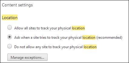
The website must have permission before use your location information. You can let websites use your location information automatically or obtain a permission request first. This is a common requirement when an API tries to interact with something outside a web context, especially to avoid sharing user-specific information. To see the geolocation information, follow these steps:
- Open the Settings option in Chrome and type
locationin the search field, as shown in the following screenshot:
- Open the Content settings pop-up dialog by clicking on the button of the same name, scroll down the content, and you'll find the Location settings:
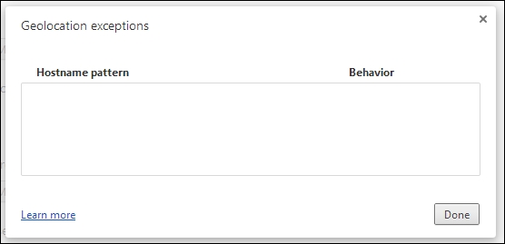
- Choose the recommended option and open the Geolocation exceptions dialog by clicking on the Manage exceptions button. For now, it will not contain our website, as shown in the following screenshot:
- Run the
geolocationapplication. The Chrome web browser will ask you for permission to use your location information, as shown in the following screenshot: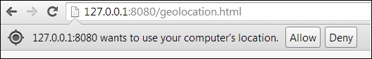
- You can allow or deny location requests for this website. Your choice completes the future permission requests with the value of
geoposition. The website is then added to the list of Geolocation exceptions. Open the Geolocation exceptions dialog again to see your website: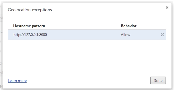
Any error that occurs in the
geolocationservice will be printed:Network location provider at 'https://www.googleapis.com/' : Returned error code 400.
- We will now run
pub servefrom the root folder of our project:Loading source assets... Serving geolocation web on http://localhost:8080 Build completed successfully [web] GET /geolocation.html => geolocation|web/geolocation.html [web] GET /geolocation.css => geolocation|web/geolocation.css [web] GET /packages/browser/dart.js => browser|lib/dart.js [Info from Dart2JS]: Compiling geolocation|web/geolocation.dart... [Info from Dart2JS]: Took 0:00:27.723586 to compile geolocation|web/geolocation.dart. Build completed successfully [web] GET /geolocation.dart.js => geolocation|web/geolocation.dart.js [web] GET /geolocation.dart.js.map => geolocation|web/geolocation.dart.js.map
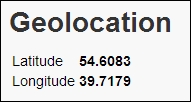
- Then, open the web application in the Chrome web browser to get the following result:
Your example will be more interesting if you add Google Maps to show your current position on a real map.
Add the google_maps package to your project and make the following changes to the code:
import 'dart:html';
import 'package:google_maps/google_maps.dart';
void main() {
final mapOptions = new MapOptions()
..zoom = 15
..mapTypeId = MapTypeId.ROADMAP;
final map = new GMap(querySelector("#map_canvas"), mapOptions);
window.navigator.geolocation.getCurrentPosition()
.then((Geoposition geoposition) {
Coordinates coords = geoposition.coords;
querySelector("#latitude").text = coords.latitude
.toStringAsPrecision(6);
querySelector("#longitude").text = coords.longitude
.toStringAsPrecision(6);
//
map.center = new LatLng(coords.latitude, coords.longitude);
}, onError: (PositionError error){
print(error.message);
});
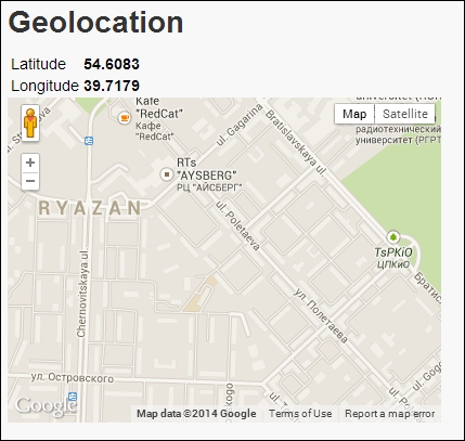
}In mapOptions, we specified the zoom and type of view. Maps can be presented in terms of the satellite, terrain, or hybrid view. Using the Google Maps API is very simple. Just add the div element with the specified ID to your HTML page. Then, execute the pub serve command to compile your code and run the server. When you open the Geolocation page in the Chrome web browser, you will get the following result:
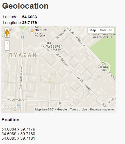
Geolocation APIs can monitor the current location of your device using the watchPosition method. With the enableHighAccuracy parameter, the geolocation API starts to use more accurate hardware available on your device. This method returns a stream of geoposition coordinates. You only need to listen to the events to track changes in your current position. The code is as follows:
import 'dart:html';
import 'package:google_maps/google_maps.dart';

void main() {
  final mapOptions = new MapOptions()
  ..zoom = 25
  ..mapTypeId = MapTypeId.ROADMAP;
  final map = new GMap(querySelector("#map_canvas"), mapOptions);

  window.navigator.geolocation
  .watchPosition(enableHighAccuracy:true)
   .listen((Geoposition geoposition) {
    Coordinates coords = geoposition.coords;
    map.center = new LatLng(coords.latitude, coords.longitude);
    //
    querySelector("#location_tracker").append(new DivElement()
    ..text = coords.latitude.toStringAsPrecision(6) + " x " +
      coords.longitude.toStringAsPrecision(6));
  }, onError: (PositionError error){
      print(error.message);
  });
}
When you run the web application, you will receive the following result: