Learn to use the Google Map Interfaces
Search for local business
Let Google Map give you driving directions
Get more visibility by adding your business
Learn how you can go farther with Google Maps
Google Maps (maps.google.com) uses Google’s powerful search technology to power many map-based services. Dynamic, interactive maps allow you to scroll to new map areas without waiting for the entire map to refresh. Google Maps simplifies getting directions, finding businesses, and obtaining satellite views of the Earth using either your mouse or keyboard. The map information can even be accessed with many mobile devices. Google Maps utilizes a combination of JavaScript and XML commonly referred to as Ajax, for faster screen loading and user customization.
Much of the data Google Maps uses to calculate these routes comes from a geographic information system provider called Navteq. Its digital map database is used by businesses for a variety of things including fleet management and GPS navigation. Navteq was recently selected as the primary map data provider for the U.S. government.
Because Google Maps uses this satellite data to plot your route, these directions are far more useful than those you might plot using a traditional paper map. One-way streets or Do Not Enter signs are already accounted for, and this information can be updated much faster digitally and more frequently than traditional paper maps. Similarly, information about new roads, road closures, and new construction is already included in your Google Maps directions.
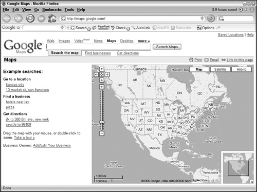
The first time you visit Google Maps (http://maps.google.com), you see the familiar Google search box at the top of the page and a map of the entire continental United States with Search the map, Find businesses, and Get directions links (see Figure 12.1). You can change the map that loads on startup to a view of your home city or anywhere else you like.
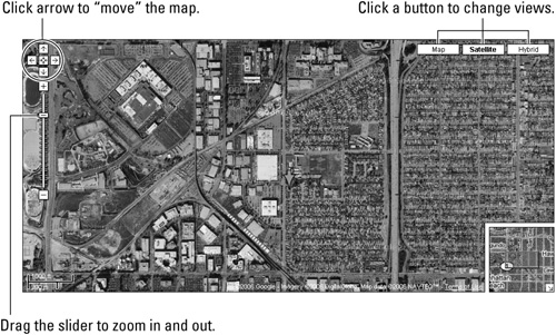
Figure 12.2 shows you how to navigate the map interface. Three buttons at the top right within the map allow you to change the view from Map to Satellite or Hybrid with a mouse click. Buttons to maneuver around beyond the viewable region of the map appear in the upper left. Click any of these controls with your mouse to move in the indicated direction.
A pane in the lower right-hand corner of the map shows a rectangle representing the area the map includes in a field approximately nine times larger than that. Click and drag this rectangle in any direction within the larger field to see adjacent areas. Additional links on this page allow you to save locations, add or edit your business, or access Maps Help with a mouse click. Finally, a distance scale appears in the lower-left corner of the map; it adjusts itself automatically depending on the degree to which the map is zoomed in or out with distance displayed in U.S. Customary and Metric units.
From the Google Maps home page, type an address into the Search box to find and display a map for that location. Any of the following formats work:
City, State. For example, Portsmouth, NH.
City Country. For example, Moscow Russia.
Number Street City State. For example, 874 Elm Street Alexandria Virginia.
Zip Code/Postal Code. For example, 96720.
Latitude and longitude coordinates in either decimal or DMS (Degrees/Minutes/Seconds) format also work. Commas are not necessary. More general searches such as pizza, or office supplies, or schools place lettered balloons on the map at the location of those search items and generate a list of links with names, phone numbers, and addresses for the corresponding locations. Use the Search box to do a keyword search for the location of businesses even if the keyword does not appear in the name of that business. Similarly, type a telephone number and Google Maps places a numbered balloon at the corresponding location on your map.
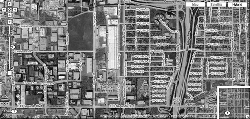
The Google Maps page defaults to the Map view. Click Satellite in the upper right-hand corner of the map to change the view of the map to a scalable satellite or aerial image of the corresponding location (see Figure 12.2). Click Hybrid and Google Maps superimposes an image of streets and landmarks and their names over the satellite image (Figure 12.3).
For mouse users, Google has incorporated an intuitive suite of control buttons. The map includes five clickable buttons arranged in a cross in the upper-left corner. Click the buttons with the single directional arrows to pan to areas adjacent to the map. Click the center button of these directional arrows and return to the previous view of the map. You can do this with the keyboard as well. Press and hold the arrow keys on the keyboard to pan incrementally in the corresponding direction. Use the following keyboard keys to move in greater increments:
Page Up. North
Page Down. South
End. East
Home. West
Page Up shifts the view in the viewport up (north) so that the northernmost portion, or the preceding view, is now the southernmost. To see a map of the region just south of your current view, press Page Down. The Home and End keys allow you to pan left and right in the same fashion.
Beneath the panning buttons sits a slider control with + and − buttons above and below it. Click + to zoom in for a closer view with greater detail. Click − to zoom out and see more of the surrounding area. The +/− keys on the keyboard produce the same result.
To zoom in or out in larger increments, click and drag the rectangular handle of the ladder-like slider control in the desired direction, + or −. Notice that each degree of zoom either doubles or halves the coverage of the previous view. The distance scale automatically updates with each step you move, either in or out.
Click anywhere on the map and drag it in any direction for an even faster way to see adjacent areas. The standard arrow-shaped mouse pointer changes to a small hand that appears above the map. Clicking the left mouse button changes the mouse pointer to a grasped hand, letting you know that it has “grabbed” the map. While holding down the mouse button, you can move the map in the direction you move your mouse
The inset pane in the lower right-hand corner of the map has a blue rectangle showing the area the map covers, as well as the adjacent area surrounding this region (see Figure 12.3). This adjacent area is roughly equivalent to the area of the map you are viewing zoomed out approximately 250 percent. Click the rectangle in this box and drag it in any direction for yet another way to view the areas bordering the map. Click the arrow button in the lower-right corner of this box to toggle this feature off and on. Zooming into and out of the map, changing coverage area, is simple. See Table 12.1 for a list of shortcuts you can use to zoom in and out of the map.
Table 12.1. Zoom Shortcuts
To zoom in | Click and drag the slider up. |
Click the + sign at the top of the slider control. | |
Use the − key on your keyboard. | |
Double-click within the map. | |
Scroll wheel up. | |
To zoom out | Click and drag the slider down. |
Click the − sign at the top of the slider control. | |
Use the − key on your keyboard. | |
Double-right-click within the map. | |
Scroll wheel down. |
Google Maps makes the process of finding a particular business by searching on the business name or type of business, such as a pizza restaurant, or gas station, in any area very easy. Just type the name of the business and the city or zip code, and Google Maps searches for the map and produces a results list of businesses matching your search. You can also type pizza, or other keyword identifying a business and Google will find related businesses.
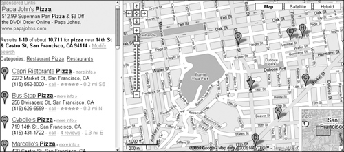
The location of these businesses is plotted on your map with small orange location balloons, called DOT icons, cross-referenced by letter to the results list of matching businesses. The results list includes the address and telephone number of those businesses. If you don’t know the name of the business, type a keyword like cleaners or hardware stores in the Search box. Google Maps returns a list of appropriate matches for you to select from. Once you have a map for your desired location, refine your search by typing additional keywords, for example: 24 hours or foreign. Google Maps adds or removes results and the corresponding DOT icons located within your particular map view.
When you choose a DOT icon on the map and click on it, two things occur. An information balloon (Figure 12.4) appears over your selected location and the name is highlighted with a gray box in the results list to the left. You can make the information balloon appear by clicking the link for that business in the result list as well.
Note
Switching to Satellite or Hybrid views can return an aerial view of the business or building you are looking for.
The information balloon contains the name, phone number, and address of the selected business as well as links for directions to its location from yours, or an option to plot a course using that location as your starting point (read more in Getting Directions). Additionally, a link appears to upload these directions to your cell phone or other mobile device. Often, a link to that company’s Web site is displayed. Click the small x (Close button) to make the information balloon disappear, or choose another location balloon or entry in the results list. Click any unlabeled section of the map to remove the info balloon.
Click the send to phone link in the information balloon, and another balloon appears. Type your phone number and select your provider from the drop-down list, and Google Maps sends the information balloon data to your mobile device. This is a very efficient way to copy your directions and bring them along on the way to your objective.
Google Maps provides more than one method for plotting a course to your destination. If you have followed the steps in the preceding section and already have an information balloon, you are practically there. Try this:
Click the to here link in the information balloon. Google Maps prompts you for a starting address.
Type your starting address as completely as possible (street number, city, state) in the Start Address box and then click Go (or press Enter). Google Maps refreshes the map, charting a course from your start point to your destination. New DOT icons appear with a green start (or play) icon marking your start address and an orange stop icon at your destination.
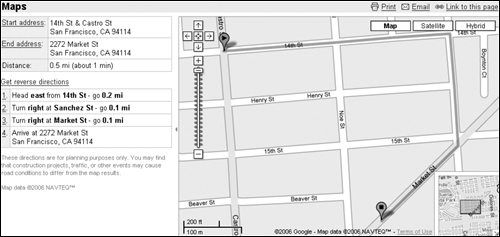
On the left side of the screen, as shown in Figure 12.5, step-by-step instructions appear outlining each turn you will make and the distance traveled on each road. These steps are numbered. Click on the number for an intersection and another information balloon appears at that portion of the route. The balloon reveals another small inset map of just that portion of the route. You can zoom in or out of this map using the +/− buttons, or, like the main map, switch to Satellite or Hybrid views. Click the Start address or End address links to get the inset map for your start and end points. Click the Reverse directions link to rechart a course from your destination to your start point. All the route steps are updated.
To generate directions using Google Maps’ single search box convenience, type your start and end points separated by to; for example, type flint michigan to dallas tx in the Search box, and Google Maps produces the appropriate maps and instructions.
Click the Get directions link and a second search box appears, representing the end points of your trip. If you have already loaded a specific map, one of these search boxes will already be filled in for you. Fill in the other box, click the Get Directions button (not the Get directions link) and let Google Maps chart your course.
You may find it useful to save a particular map as your start location. Here’s how:
Click the Search the map link to find your home street, hotel, or workplace. C
Click the Make this my default location link. On all subsequent visits to Google Maps, this map appears and this address is the default starting point in the Get Directions feature, eliminating the need to type this starting point (for example, your home address) each time. You can change this default any time by repeating these steps.
Note
When you go to http://maps.google.com, your saved default address/location appears in the upper-left corner of the screen. Click the Clear link to restore the Google Maps default start page.
Although Google Maps uses a variety of sources to collect and display business information like telephone directories and Web search results, it is possible that information about your business is missing, inaccurate, out of date, or incomplete. In fact, you may occasionally see an unverified listing- Report incorrect data link in a given address information balloon. On the left side of the Google Maps home page is a list of example searches, and beneath this is the Business Owners: Add/Edit Your Business link. Click this link and find links for the following:
Login to your Google Account
Create a Google Account
Local Business Center
Create, Edit, or Suspend your listing
Add a coupon to your Google Maps Listing
These services are free, but you must have a Google account or a Gmail account to use them. Setting up an account is free as well, although additional services, such as being listed as a sponsored link or creating local business ads have associated fees and require a Google account.
Note
At time of this book’s printing, only businesses in the United States, Canada, the United Kingdom, China, and Japan can currently create local business ads.
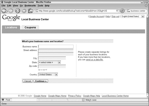
Once you create an account and/or log in, you are rerouted to the Google Local Business Center. Follow these steps to include your business in Google maps:
Type your business name and address in the appropriate text boxes (see Figure 12.6).
Click Continue to add more specific options such as a description of your business, telephone numbers, hours of operation, and more. Optional text boxes allow you to type your Web site URL or e-mail address.
Click Continue again to select a category to aid Google in generating relevant search results for people who may try to find your business or one like it, or click Continue again for options to see a list of all available categories.
Select a category or recommend one for consideration by Google. Select up to five categories by choosing them from the list of categories and clicking Add to List.
Click the Continue button, taking you to a page where you can preview your business listing. You will then need to verify your listing. Select either to receive a phone call or a post card and click Continue, nearly completing the process.
Once you add your business information, preview and accept your listing, Google provides you with a PIN. This number is used to verify your listing and to update it in the future. Next, Google calls your business number (either immediately or in five minutes) and an automated system asks you to enter the PIN on your phone keypad. You also have the option to verify your listing by mail, with a verification postcard being sent to your business address. Google seems to know if you list a cell phone number for your business phone and then requires verification by mail.
Caution
If you choose the mail option or are required to verify by mail, your mailing address must be a physical location where you can receive mail. Post office boxes are not accepted.
Now that you have verified your listing, the automated voice system alerts you that your listing should appear in about four weeks.
Once your business listing is approved, you can return to the Local Business Center (www.google.com/local/add/login) and, after signing in to your account, click the Coupons tab, create a coupon that will appear on the business details page of your listing in Google Maps. A list of editorial guidelines and recommendations, and disclaimers appears in Google Maps Help section such as:
Please note that if you wish to limit coupon use to one per customer
you must include this in your coupon text. We cannot restrict the
number of times a customer can print your coupon.
Sponsored links appear at the top of the search results listing. These sites pay a fee and then place a bid for certain keywords. Google uses a complicated algorithm to determine which of the sponsored links appear for a given search and in what order. While the process for obtaining a sponsored link is not terribly difficult, the fee structure gets a bit complex as the hosts of these links must bid in an auction for certain keywords (words that a Google user might type into a search box to find a particular product). Whoever bids the highest for a particular keyword gets, if not a higher position in the sponsored list ranking, at least a heavier weighting in the Google search algorithm. Sponsors pay only when their ads appear above a given search results list, and then only if their links are clicked. However, they don’t pay the amount they bid to use that particular keyword. They pay one cent higher than the next highest bidder committed for that same keyword, a figure the sponsor does not know in advance.
Because the number of possible clicks on a sponsored link in a given time period is potentially huge, and because the sponsor does not know precisely what rate a given keyword is going for on a particular day (one cent more than the next highest bid), the cost for these links might be staggering. To give the sponsors some degree of control over their advertising budgets Google provides a number of ways to control the cost, such as only paying for x number of clicks, or a certain dollar figure per day.
Web developers, programmers, hackers, and gamers not affiliated with Google are hard at work reverse-engineering and reintegrating Google Maps to help push this fascinating tool to its limits. Google has even released its own set of programmer tools called the Google Maps API (application programming interface). If you have a Google account, sign up to receive an API key and agree to the terms of service, you can embed Google Maps into your own Web site or make dynamic overlays to place over Google Maps to create your own routes and pathways that automatically scale and adjust as you zoom or drag your map.
Link your own photos or videos to points of the map to create your own interactive tour, with events triggered as the viewer clicks on the corresponding point on the map. Or, create your own animated map that pans or zooms to predetermined locations. The Google Maps API contains tools to create your own custom map icons. You can even create your own controls for users to explore your map.
A geocoder feature is included with the Google Maps API. Use it to generate longitude and latitude coordinates from points on the map. Even though Google Maps does not incorporate this feature on its site, you can improvise it:
Search for the location for which you want coordinates.
Get the desired location as close to the center of the map as possible.
Click the Link to this page link above the upper-right corner of the map.
The address bar in your Web browser changes to something like http://www.google.com/maps?f=q&hl=en&q=space+needle&ie=UTF8&z=12&ll=47.624446,-122.349586&spn=0.104359,0.346069&om=1&iwloc=A.
In this example, the latitude is 47.624446. The longitude is −122.349586. While this is a fairly quick and easy way to pinpoint a single spot, the Google Maps API allows you to enter a string of addresses or locations and geocode them all at once.
By integrating information from other Web sites, developers have greatly expanded the functionality of Google Maps. One popular site takes housing information from craigslist.org to chart the location of homes available on a Google Map. By incorporating FDIC bank office data, another site is able to show you the nearest branch of your bank regardless of where you are in the United States. Sites with dynamic weather maps, updating crime statistics, potential mates, recent earthquakes, even a site showing the locations of the biggest election donors, already exist to inform and entertain you. A user in San Jose has a map of gas prices in that city, constantly updated by visitors to his site looking for the cheapest fuel. By providing end users the tools to link dynamic free data feeds or their own research to Google Maps a new way of viewing the country is under development on the Web.
With its simple, intuitive interface combined with Google’s powerful search capabilities, Google Maps has made the mundane and cumbersome details of getting from point A to point B, or finding a decent place to eat at 3 a.m. fast, efficient, and fun. The ability to click and drag around the field of view and zoom in and out with the flick of the scroll wheel provides a refreshing update to one of oldest navigational tools. The speed at which a destination can be located, a route plotted, and that information sent to your mobile device is almost dizzying, but hours can be lost idly playing with the tools and switching back and forth to hybrid and aerial views because it’s so simple yet engaging.
Despite the ease of getting your business information to appear on Google Maps, it is probably unnecessary, as Google’s search technology has undoubtedly already included it, waiting for you to add your unique marketing flourish. But even with all this power at your fingertips, developers are constantly striving to add another degree of utility to this tool suite.
Switching to the Satellite view can give some notion of terrain, and overlaying a route or location icon adds a sense that you are navigating a real space. Drop shadows on the DOT icons and information balloons enhance this effect. But ultimately, you are still manipulating static two-dimensional images. While it might not be more practical, wouldn’t it be a bit more fun to explore the planet in three dimensions? Why can’t Google render buildings as they rise above the landscape instead of just flat 2-D aerial views? See how Google has addressed this question in the next chapter.

