
6
Which Major Rivers Flow Uphill?
As all of us know, jellied biscuits fall to the rug (frequently upside down), baseballs fall to the center fielder (frequently with two outs and bases loaded), and car keys fall to the pavement (frequently through sewer gratings). And rivers fall—or as we usually say—flow downhill. So how can a river flow uphill? Well, be patient. That matter will be explained in a page or two.
We start our consideration of this topic with a short trip through some trigonometry and analytic geometry. As illustrated in figure 6.1, suppose that you have a circular cone made of cheese on the table in front of you. With the blade of your knife or saw parallel to the table top, you slice through the cone of cheese. The cross-section of the cut cone is a circle. Your second slice, with the knife blade held at a small angle to the plane of the table, yields an ellipse. The third slice, cut at an angle parallel to the side of the cone, gives a parabola. And your fourth slice, with the knife blade at a steep or even a vertical angle, produces a hyperbola.
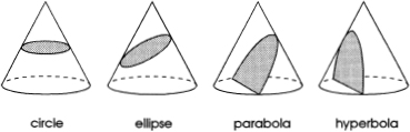
FIG. 6.1
The conic sections.
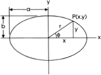
FIG. 6.2
The ellipse.
These shapes—the circle, ellipse, parabola, and hyperbola—are the “conic sections.” They have been studied and analyzed by mathematicians for more than two thousand years. Incidentally, if you do not happen to have a cone-shaped piece of cheese around, you can use a flashlight and a nearby wall to view the conic sections. This methodology is easier, less expensive, and involves fewer calories.
For our uphill-flowing river problem, we are interested in only the second of these conic sections: the ellipse shown in figure 6.2. This is an extremely important curve; it appears in a great many problems of mathematics and science. For example, it describes the paths that the planets and most comets follow in their orbits around the sun. It is utilized as the profile for some types of arch bridges and other structures. It provides the basis for an important subject in mathematics called elliptic functions.
From analytic geometry we establish that the equation of the ellipse is
![]()
where x and y are the coordinates of a particular point on the curve, a is half the length of the major (longer) axis of the ellipse, and b is half the length of the minor (shorter) axis. In the special case a = b = r0, equation (6.1) reduces to ![]() this is the equation of the circle. From equation (6.1) we obtain the expression
this is the equation of the circle. From equation (6.1) we obtain the expression
![]()
which says that for every value of the quantity x, there are two corresponding values of the quantity y. Suppose that a = 5 and b = 3. For the value of x = 4, for example, we determine from equation (6.2) that y = + 1.8 and – 1.8.
Back to equation (6.1) and figure 6.2. If this ellipse is rotated about the x-axis we generate a solid of revolution that looks somewhat like a football or watermelon; it is called a prolate ellipsoid. Alternatively, if the ellipse is rotated about the y-axis, the solid of revolution is termed an oblate ellipsoid; it resembles a slightly flattened pumpkin or the planet earth.
That is correct: the planet earth. As we know, the earth makes a complete rotation about its axis every 24 hours. This rotation is sufficiently fast to produce a velocity of about 460 meters per second at the equator. Like everything else that rotates about an axis, the earth creates centrifugal forces. For the rotating earth, these forces are large enough to significantly distort its shape from a perfect sphere to a slightly flattened pumpkin, that is, an oblate ellipsoid.
According to Abramowitz and Stegun (1965), the equatorial radius of the earth is a = 6,378,388 m and the polar radius is b = 6,356,912 m. The difference between these two distances indicates that the earth's diameter measured between two points on the equator on opposite sides of the earth is about 43 kilometers greater than the diameter from the north pole to the south pole.
We are now at the threshold of our “river flowing uphill” problem. Indeed, here is the gimmick (a bit sneaky, but never mind): What major rivers of the world have their mouths further from the center of the earth than their sources? As you eagerly endeavor to find answers to the question, you will be forced to combine these topics of mathematics with some topics of geography.
First we cast our mathematics into a more useful form. Refer-ring to figures 6.2 and 6.3 and the relationships
![]()
where r is the distance to the center of the earth and ø is the latitude of a particular point on the surface, we convert equation (6.1) into the form


FIG. 6.3
Definition sketch for the coordinates of the earth considered as an oblate ellipsoid.
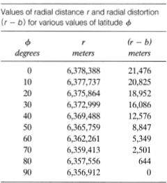
TABLE 6.1
Since this is somewhat awkward to use for computation, we utilize the expression sin2 ø + cos2 ø = 1, to obtain
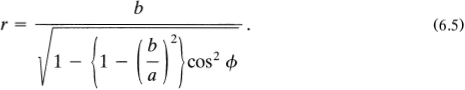
Substituting a = 6,378,388 m and b = 6,356,912 m into this equation gives
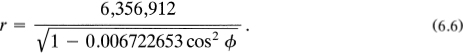
Table 6.1 lists values of r for various values of latitude, ø. It also indicates the amount of radial distortion (r – b) due to centrifugal force.
Now what rivers are likely to be uphill flowing? First, we exclude those flowing mostly west to east or east to west, since, in these cases, there is little or no change in latitude. Evidently we seek north to south or south to north rivers. Obviously, you will need some maps and tables to proceed with your analysis. A good deal of information can be obtained from the excellent atlas of Rand McNally (1978). Contour maps are needed to determine elevations of sources.
A good first guess is: the Mississippi River. This river flows almost directly north to south. It has its source in Lake Itasca in northern Minnesota at a latitude ø1 = 47.5°, and an elevation h1 = 450 m above mean sea level. From equation (6.6), the distance from the center of the earth to sea level at this latitude is r1 = 6,366,687 m. The source is 450 meters higher. So d1 = r1 + h1 = 6,367,137 m is the distance from the source of the Mississippi to the center of the earth.
The mouth of the Mississippi is about 120 kilometers southeast of New Orleans in the Gulf of Mexico at a latitude ø2 = 29.0°. At sea level we have h2 = 0. From equation (6.6) we compute r2 = 6,373,321 m, and since h2 = 0, the distance from the mouth of the river to the center of the earth has the value d2 = r2 + h2 = 6,373,321. The difference between these two distances is Δ d = d2 – d1 = +6,184 m. This result indicates that the mouth of the Mississippi River is 6,184 meters further from the center of the earth than is its source. Accordingly, this major river “flows uphill.”
The Missouri River, with its source in Madison County, Montana, and mouth in the Mississippi River near Saint Louis, also flows uphill. In this case, Δd = 2,365 m. The Rio Grande starts in San Juan County, Colorado, at an elevation h1 = 1,830 m and latitude ø1 = 37.7°. Its mouth is in the Gulf of Mexico with ø2 = 26.0° and h2 = 0. So, with Δd = 2,080 m, the Rio Grande flows uphill. The Colorado-Green River also flows uphill with Δd = 650 m.
Are there other uphill-flowing rivers in North America? Undoubtedly. Try the Arkansas and the Ohio; possibly the Connecticut, Hudson, and Sacramento. However, the Columbia, Saint Lawrence, and Yukon Rivers, with small latitude changes, probably do not qualify. The Mackenzie River, though it flows mainly south to north, flows the wrong way to be a candidate for uphill flowing.
On this latter point, the Nile River flows almost due north from its source in Lake Victoria (ø1 = 2.0°, h1 = 1,135 m) to its mouth in the Mediterranean (ø2 = 31.5°, h2 = 0). Accordingly, d1 = 6,379,498, d2 = 6,372,503, and the difference Δd = d2 – d1 = – 6,995 m. The minus sign means that the Nile is flowing downhill in two senses: (a) it goes from a high place to a low place on the earth's surface and (b) its mouth is closer to the earth's center than is its source. Too bad; the Nile does not even come close.
The important criterion to be “uphill flowing” should now be clear: the river must have its source at high latitude and its mouth at low latitude.
PROBLEMS As best you can, calculate Δd for some of these rivers: Amazon, Mekong, Volga, Yenisei, Danube, Rhine, Yangtse, and Zaire.
An Epilogue: The Shape of the Earth
Two comments: First, we have covered some topics involving mathematics and geography in our deliberations about rivers flowing uphill. Let's go a step further and include a bit of history in our considerations. Second, though we label this section an “epilogue” to our chapter, it is distinctly a “prologue” to the entire matter.
A word of explanation: As recently as the early eighteenth century, there was not even agreement among the world's scientists about the shape of the earth. The French believed it to be a prolate (watermelon-shaped) ellipsoid; the British believed it to be an oblate (pumpkin-shaped) ellipsoid.
In order to settle the matter, in the spring of 1735, the French Academy of Sciences organized two scientific expeditions to measure arcs of the earth's surface: one near the equator and the other as close as possible to the North Pole. Soon after, two teams were deployed, one to Ecuador in South America, the other to northern Sweden in Europe. Though the team to Sweden returned to France a year later, ten years passed before the Ecuadorian team finally got back to Paris.
An extremely interesting story of the experiences and main achievements of the two scientific expeditions is given by Fernie (1991, 1992) in a series of three fascinating articles entitled “The Shape of the Earth,” which are highly recommended reading. By the way, as we all know, the earth is oblate.