
Coordinate Systems
No matter what kind of drawing you do in AutoCAD, you need a systematic method of specifying points. Points define the beginnings and endpoints of lines, the centers of circles and arcs, the axis points of ellipses, and so on. The capability to place points accurately is important. When an AutoCAD command prompts you for a point, you can either specify a point on the screen with the mouse or pointing device, or enter coordinates at the command line. When entering points, AutoCAD uses a three-dimensional Cartesian, or rectangular, coordinate system. Using this standard system, you locate a point in 3D space by specifying its distance and direction from an established origin measured along three mutually perpendicular axes: the X-axis, Y-axis, and the Z-axis. The origin is considered to be at 0,0,0. Figure 6.1 illustrates such a coordinate system. Only two dimensions are depicted with the Z-axis projecting up, perpendicular to the page. If you are concerned only with two-dimensional drawings, this is the presentation of AutoCAD’s coordinate system that will be seen.
Figure 6.1. The X- and Y-axes in a 2D coordinate system.

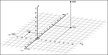
In Figure 6.1, the 4,6 coordinate indicates a point 4 units in the positive X direction and 6 units in the positive Y direction. Points to the left or below the origin have negative X and Y coordinate components, respectively. Figure 6.2 illustrates the same coordinate system, only now the third dimension and the Z-axis are shown. To specify 3D points, you add a third element to the coordinate designation. The point 4,6,6 in Figure 6.2 is located 4 units in the positive X direction, 6 units in the positive Y direction, and 6 units in the positive Z direction. The system of reckoning coordinates is independent of the units used so that distances can be in any measurement; for example, the X direction could be Imperial feet or inches, or metric centimeters or kilometers.
Figure 6.2. The 3D rectangular coordinate system.
Later in this chapter, you will learn about the various ways that you can change the origin as well as the orientation of the three axes of AutoCAD’s rectangular coordinate system. No matter how the coordinate system is oriented, you must know how to enter points.
Coordinate Point Entry Methods
Many of the drawings you make in AutoCAD—regardless of their eventual complexity—consist of a few relatively basic AutoCAD objects such as lines, circles, and text elements. These objects require that you enter points that specify their location, size, and direction. Additionally, many editing operations also require that you specify points. There are four ways to enter points or coordinates in AutoCAD:
Using absolute coordinates
Using relative coordinates
Using direct distance entry
Using coordinate display
Using Absolute Coordinates
Absolute rectangular coordinates are always measured from the origin point: 0,0,0. In AutoCAD, you specify an absolute coordinate from the keyboard by typing in the X-, Y-, and Z-axis values separated by a comma: X,Y for 2D points, or X,Y,Z for 3D points.
You don’t need to use a plus sign (+) if the displacement from the origin is positive. You must, however, place a minus sign (-) in front of displacements in the negative direction: -2,3 or 4,-6,3.
Absolute polar coordinates also treat a 2D coordinate entry as a displacement from the origin, or 0,0, but you specify the displacement as a distance and an angle. The distance and angle are separated by a left-angle bracket (<) with no spaces: distance<angle (for example, 25<135).
Positive angles are measured counterclockwise from an assumed 0 degree that lies, by default, along the positive X axis as shown in Figure 6.3.
Figure 6.3. Default angle directions.

Tip
When entering the angle portion of polar coordinates, you can specify the angle as either positive (counterclockwise) or negative (clockwise). Thus, 37<90 is equivalent to 37<–270.
This applies to both absolute and relative coordinate entries.
Note
You can reverse the positive and negative directions of angles, so that positive values measure clockwise and negative values measure counterclockwise. This is accomplished by selecting the Clockwise option from the Drawing Units dialog box. Additionally, you can control the direction of the 0-degree baseline from which all angles are measured. For more information, refer to Chapter 3, “Controlling the AutoCAD 2002 Drawing Environment.”
In the following exercise, you use both absolute rectangular and absolute polar coordinates to draw the outline of a fastener.
Exercise 6.1 Using Absolute Rectangular and Absolute Polar Coordinate Entry
1. |
If necessary, start AutoCAD and begin a drawing using the Start from Scratch option. |
2. |
Start the LINE command by either typing L
or clicking on the Line tool on the Draw toolbar. Enter the following coordinates at the prompts: LINE Specify first point: 4.5,5 Specify next point or [Undo]: 6.5,5 Specify next point or [Undo]: 9<38.34 Specify next point or [Close/Undo]: 7.8<25.36 Specify next point or [Close/Undo]: 6.5,4 Specify next point or [Close/Undo]: 4.5,4 Specify next point or [Close/Undo]: C |
3. |
This short exercise demonstrates the limitations of absolute coordinates. Although absolute coordinates are adequate for designating the beginning of a line, measuring subsequent points in relation to the drawing’s origin is cumbersome and often inaccurate. When the lines outlining an object (such as the fastener in the preceding exercise) are not orthogonal, absolute coordinates are inadequate if any degree of accuracy and efficiency is desired. The use of relative coordinates solves this problem.
Using Relative Coordinates
In almost any kind of drawing, after you have established the beginning of a line, you usually know the X and Y displacement or the distance and angle to the next point. Relative coordinates do not reference the origin point but are determined relative to the last point. You can use this more straightforward method with either relative rectangular or relative polar coordinates. To distinguish relative coordinate entry from absolute entry, you precede relative coordinates with the @ symbol (for example, @1.5,3 for relative rectangular entry or @2.6<45 for relative polar entry).
In the preceding relative rectangular entry, the point specified lies at a displacement of 1.5 units in the X-axis direction and 3 units in the Y-axis direction from the previous point. In the relative polar entry, the point lies 2.6 units at an angle of 45 degrees from the previous point.
In the following exercise, the usefulness of relative coordinates is shown in drawing a fastener similar to the one in the previous exercise.
Exercise 6.2 Using Relative Coordinates
Continue from the previous exercise.
1. |
Start the LINE command by typing L
or clicking on the Line tool on the Draw toolbar. Enter the following coordinates at the prompts: LINE Specify first point: 9,5 (Note this is an absolute coordinate.) Specify next point or [Undo]: @2<0 (Note this is a relative polar coordinate.) Specify next point or [Undo]: @.8<46 Specify next point or [Close/Undo]: @0,-2.2 (Note this is a relative rectangular coordinate.) Specify next point or [Close/Undo]: @.8<134 Specify next point or [Close/Undo]: @2<180 Specify next point or [Close/Undo]: C |
2. |

Note
The angles involved or the availability of distance information will usually determine whether it is easier to enter the next point using relative polar or relative rectangular coordinates.
As you can see, relative coordinate point entry is much easier to use and permits more accuracy than absolute rectangular entry. Even when your drawing involves purely orthogonal displacements, relative coordinate entry is the superior and usually the only accurate method.
Direct Distance Entry
A variation of relative coordinate entry, called direct distance entry, is supported in AutoCAD. In direct distance entry, rather than entering coordinate values, you can specify a point by moving the cursor to indicate a direction and then entering the distance from the first point. This is a good way to quickly specify a line length. This method is used primarily when the displacements involved are orthogonal and you can have the ORTHO drawing aid turned on. The following exercise demonstrates the use of direct distance coordinate entry.
Exercise 6.3 Using Direct Distance Coordinate Entry
1. | |
2. |
Ensure that ORTHO mode is active by observing the ORTHO button in the status bar at the bottom of the AutoCAD drawing window. If the button is depressed, ORTHO mode is on. If ORTHO mode is off, click the ORTHO button. |
3. |
With ORTHO mode on, move the crosshairs cursor any distance to the right of the point entered in step 1. Answer the current prompt as follows: Specify next point or [Undo]: <Ortho on> 2.3 (Enter) |
4. |
Note that the first line segment is drawn 2.3 units orthogonally to the right of point 7.5,7.5. Also note that your coordinate entry, although “relative” to the preceding point, did not require the @ prefix. |
5. |
Now respond to the current prompt with a standard relative polar coordinate: Specify next point or [Undo]: @.8<46 (Enter) |
6. |
Enter the next line segment using direct distance entry by moving the crosshairs cursor any distance below the last point and entering the following at the current prompt: Specify next point or [Close/Undo]: 2.2 (Enter) |
7. |
Note again that the preceding entry did not require the leading @ symbol and that the line segment was drawn 2.2 units in the direction of the crosshairs cursor. |
8. |
Again use standard relative polar coordinate entry for the next line segment: Specify next point or [Close/Undo]: @.8<134 (Enter) |
9. |
Respond to the current prompt by placing the crosshairs cursor to the left of the last point and entering the following: Specify next point or [Close/Undo]: 2.3 (Enter) Specify next point or [Close/Undo]: C (Enter) |
The outline should be similar to that completed in the previous exercises.
Direct distance entry provides a more direct and easier method of entering relative coordinates when the point lies in an orthogonal relationship to the previous point—a common situation in most drawings. Of course, if the point you want to designate lies on a snap point, whether or not orthogonal to the previous point, you can bypass keyboard entry by simply snapping the cursor to and clicking on the point. (The concept of snapping is covered later in this chapter.)
Note
AutoCAD 2000 introduced a new feature called AutoTracking, which allows you to simulate the effect of ORTHO mode—constricting the cursor’s angular movement—but allows you to apply it in increments other than ORTHO mode’s 90-degree increments. AutoTracking is discussed later in this chapter.
Coordinate Display
The coordinate display window located at the bottom left of the status bar is useful when entering coordinates, whether you type them at the command prompt or pick points on the screen with the screen cursor. Figure 6.6 shows this display with two variations of the format.
Figure 6.6. The coordinate display window shows coordinates in the current drawing units.
![]()
The upper display shows decimal units while the lower display shows architectural units. The are three types of coordinate displays, which can display either absolute or relative coordinates, depending on the one selected and the command in progress. You can cycle through the various display types in four ways: by pressing either F6 or Ctrl+D, or by clicking or right-clicking in the display area itself. The three coordinate display types are as follows:
Static Display. Displays the absolute coordinates of the last picked point. The display is updated whenever a new point is picked.
Dynamic Display. Displays the absolute coordinates of the screen cursor and updates continuously as the cursor is moved. This is the default mode.
Distance and Angle. Displays the distance and angle relative to the last point whenever a command prompt requesting either a distance or angle is active.
When Static Display is selected, the coordinate display appears grayed-out, although the coordinates of the last selected point are still visible. At an empty command prompt (one with no command in progress) or at an active prompt that does not accept either a distance or angle as input, you can only toggle between Static Display and Dynamic Display. At a prompt that does accept or require either a distance or angle as input, you can cycle among all three display types. Pay particular attention to the coordinate display window during the following exercise.
Exercise 6.4 Cycling Through Coordinate Display Types
1. |
Continue from the previous exercise or open a new drawing. (Use Start from Scratch. You will not need to save this drawing.) |
2. |
Ensure that SNAP mode is off by observing the SNAP button in the status bar at the bottom of AutoCAD’s application. If the button is raised, SNAP mode is off; if the button is depressed, SNAP mode is on. If necessary, click the button to turn SNAP mode off. |
3. |
Ensure that the current mode setting of the coordinate display is off by pressing F6 until the display appears grayed-out. |
4. |
Ensure that ORTHO mode is off by clicking the ORTHO button on the status bar if it is depressed. |
5. |
Now move the screen cursor within the drawing area. Note that the coordinate display remains static. |
6. |
Click in the coordinate display area. Note that the display is no longer grayed-out. |
7. |
Now move the screen cursor and notice that the coordinate display is continuously updated. The coordinate display type is now Distance and Angle. |
8. |
Start the LINE command by typing L
and pressing Enter. |
9. |
Respond to the Specify first point: prompt by typing 4,7
and pressing Enter. |
10. |
Notice that after a point has been specified, the coordinate display changes to show relative polar coordinates as you move the cursor. Type in the following absolute rectangular point: Specify next point or [Undo]: 6,7 (Enter) |
11. |
The line is drawn between the two points. Now press Ctrl+D. The display type changes to Dynamic Display, and the display is again in absolute rectangular format as you move the cursor. |
12. |
Press F6. The display type is now Static Display. The display is grayed-out and static as you move the cursor. |
13. |
Type the following at the prompt: Specify next point or [Undo]: 2,3 (Enter) |
14. |
The next line is drawn. Now click in the coordinate display window. The display type is now back to Distance and Angle, with the read-out once again in relative polar format. |
15. |
Right-click in the coordinate display window. The shortcut menu appears, and shows the three display types as Off (Static Display), Absolute (Dynamic Display), and Relative (Distance and Angle). Notice that the Relative option is grayed-out. This occurs because Relative display is the current mode. |
16. |
Choose the Absolute option. The display type changes to Dynamic Display, and the display is again in absolute rectangular format as you move the cursor. |
17. |
Right-click in the coordinate display window again, and choose the Relative option. The display type returns to Distance and Angle, with the read-out once again in relative polar format. |
18. |
Press the Esc key to end the LINE command. Then press the U key and press Enter to undo the line. Note that the display reverts to absolute rectangular because no command that accepts distance or angle input is active. |
In this exercise, you saw the three types of coordinate displays and how they can aid you in selecting points. You also manually used the four methods available to you for cycling through the three display types. Although the absolute rectangular read-out type is of limited usefulness, it can, for example, be used to specify the starting point of an object such as a wall or to specify a set of known points in a surveying data context.
Tip
If you have the Static Display active and click a grip to make it hot, the system will display the coordinate of the grip location. This is an alternative to using the ID command.