Chapter 10
Irrigation Methods
Abstract
There are different ways of application of irrigation water to the farm land known as irrigation methods, which ultimately define the magnitude of field losses and thus the field application efficiency. For sustainable planning of the irrigation project especially in terms of water use and water management, irrigation methods play a significant role. The commonly used irrigation methods are surface, sprinkler, and drip irrigation. Each method has its own merits and demerits, depending on the soil, topography, type of crops, climate, water availability and quality, and investment, which are the guiding factors for selecting an adequate irrigation method. All these aspects are suitably considered in the present chapter.
Keywords
Demerits; Drip; Field application efficiency; Irrigation methods; Layout; Merits; Selection criteria; Sprinkler; Surface
For adequate water supply to crops during the period of soil moisture deficit, various methods can be used to irrigate crops. The commonly used irrigation methods are surface, sprinkler, and drip irrigation. Each method has its own merits and demerits, depending on the soil, topography, type of crops, climate, and water availability and quality. However, in India, the commonly used method is surface irrigation in which flow of water is governed by the field slope. This chapter provides a brief description of each method.
10.1. Methods of Irrigation
Application of irrigation water by gravity to the field is known as surface irrigation. Surface irrigation is further classified, depending on the crop's water requirement and drainage needs as basin irrigation, furrow irrigation, and border irrigation.
10.1.1. Basin Irrigation
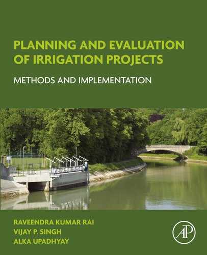
Basins are formed by constructing bunds surrounding the flat areas to prevent water from flowing to adjacent fields. This method is most applicable to crops, like paddy, which require standing water in the field. In general, the basin method is suitable for crops that are unaffected by standing water for long periods, say 12–24 h. Bunds can be constructed on flat and terrace lands. A typical view of basin irrigation is shown in Fig. 10.1.
10.1.2. Furrow Irrigation
This method of irrigation is commonly used for row crops like potato that require sufficient moisture with adequate drainage. Furrows are small channels constructed along the field slope to carry water between the crop rows (Fig. 10.2). Crops are usually grown on the ridges between furrows. Besides row crops, this method is also suitable for crops that cannot stand in water for longer periods (say 12–24 h).
10.1.3. Border Irrigation
When land is divided into several strips along the field separated by bunds, it is known as border (Fig. 10.3). Borders are sometimes called border strips. In this method, irrigation water from the field channel is fed to the border strip by simply creating the field outlet or using siphons or gates. In the border strip, location of the opening(s) should cause sheet flow along the slope guided by the bunds on either side.
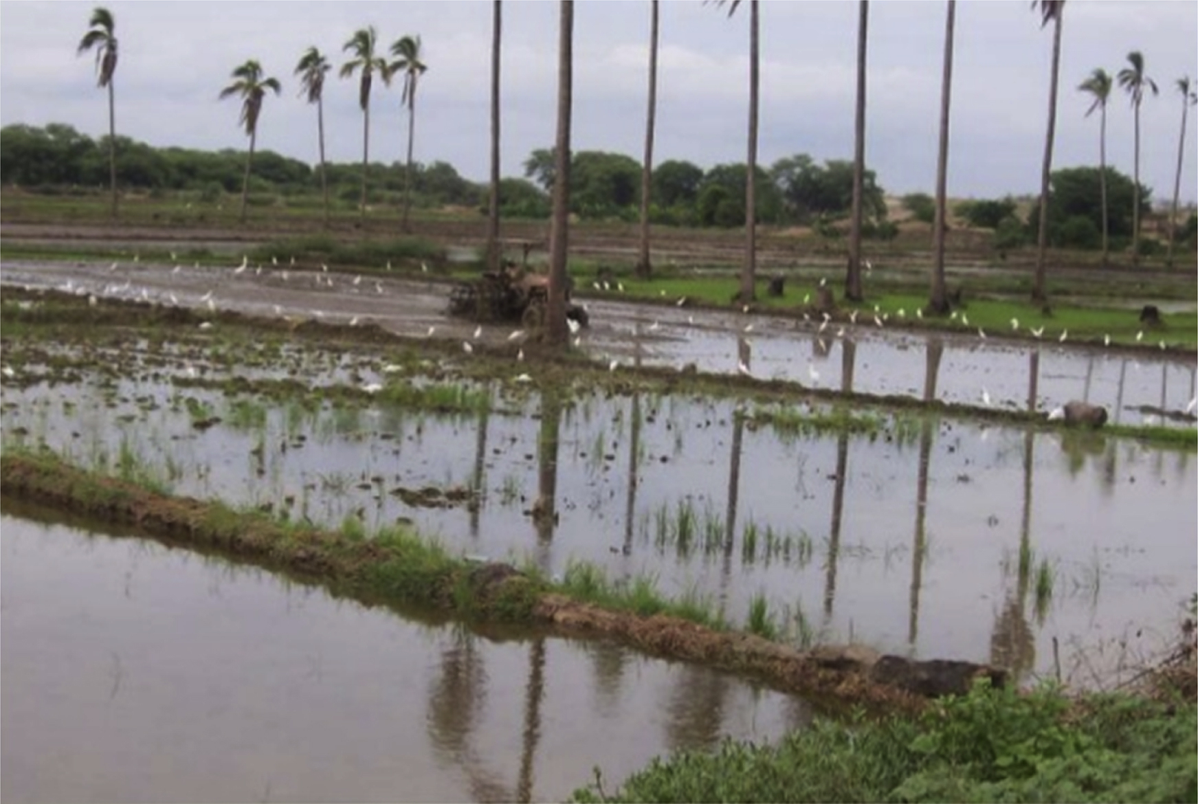

10.1.4. Sprinkler Irrigation
Sprinkler irrigation resembles natural rainfall (Fig. 10.4). Water is pumped through a pipe system and then sprayed onto the crops through rotating sprinkler heads. Generally, sprinkler irrigation is applicable to all types of crops.
Sprinkler irrigation is a method of applying irrigation water through showers resembling natural rainfall. Water distribution over the field has good uniformity. Although applicable to most soils, sprinklers are best suited to sandy soils with high infiltration rates. The application rate from the sprinkler must be chosen to be less than the infiltration rate of the soil to avoid ponding and surface runoff. Therefore the application rate should be considered on the basis of infiltration (Table 10.1). Soil that forms a crust on the surface is not suitable for sprinkler irrigation.

The advantages of sprinkler irrigation are: (1) elimination of conveyance loss and loss in cultivable areas; (2) suitability for all types of soil except heavy clay; (3) suitability for sandy soil; (4) suitability for crops for which the plant population per unit area is very high; (5) high application efficiency; (6) high yield per unit of water use; (7) mobility of system; and (8) the fact that topography is not a constraint for its application.
Table 10.1
Basic Infiltration Rates for Various Soil Types
| Soil Type | Basic Infiltration Rate (mm/h) |
| Sand | <30 |
| Sandy loam | 20–30 |
| Loam | 10–20 |
| Clay loam | 5–10 |
| Clay | 1–5 |
Some of the disadvantages of the sprinkler Irrigation method are as follows:
• High initial cost involved;
• Continuous high-energy requirement and associated costs;
• Poor application performance under high-wind and high-temperature conditions;
• High evaporation loss due to high-wind and high-temperature conditions;
• High periodic maintenance cost.
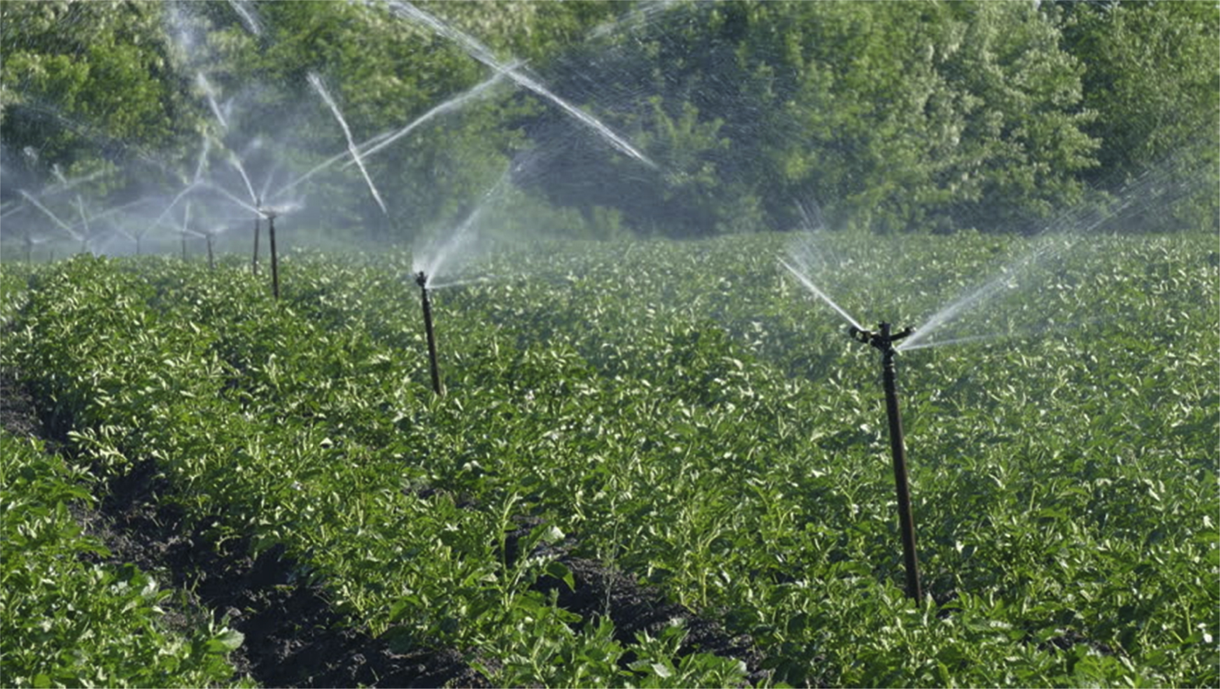
10.1.5. Drip Irrigation
In drip irrigation, water is directly applied to the crop roots using a pressurized pipe system. In this method, water is conveyed under pressure through pipe and released as drops/drips directly to soil on the field through emitters or drippers. The spacing between emitters depends upon the plant spacing. Only the immediate root zone of each plant is wetted. Therefore this can be a very efficient method of irrigation (Fig. 10.5). Drip irrigation is sometimes called trickle irrigation.
Drip irrigation or trickle irrigation directly delivers water in the form of drip through emitters on to the soil at very low rates. The application rate varies between 2 and 20 L/h depending on the soil characteristics. Unlike the sprinkler and surface irrigation methods, in this method water is applied close to the plants so that only that part of the soil in which the roots grow is wetted, therefore the field application efficiency is very high when compared with other systems. Where frequent irrigation of crops is required, drip irrigation is most suitable. This system is also suitable for water of poor quality (saline water).
The major advantages of this method are: (1) conveyance loss and loss in cultivable area are eliminated; (2) water is directly applied to the crop root and therefore there is high water distribution efficiency; (3) fertilizer or nutrient loss is minimized as it is applied directly to the plant; (4) yield per unit of water use is high; (5) significant water saving can be achieved; and (6) there is high field application efficiency.
Some of disadvantages of the sprinkler irrigation method are as follows:
• High initial cost involved;
• Problem in moisture distribution;
• Continuous energy requirement and associated costs;
• Salinity problem;
• High skill requirement;
• Sensitivity of clogging;
• Life of tube is less due to continuous exposure to sun;
• High periodic maintenance cost.
10.2. Factors Affecting the Selection of Irrigation Method
Selection of an irrigation system is the first and most important step, which needs good knowledge of the merits and demerits of different methods vis-à-vis physical parameters for crops, such as crop type, soil, topography, climate, water availability and quality, and other parameters. The merits and demerits of these methods are summarized in Table 10.2.
10.3. Layout of Basin Irrigation
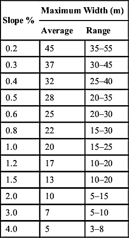
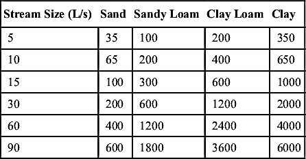
Basin layout largely depends on the soil and topography (i.e., slope) of the farm land. The approximate width of the basin with respect to the land slope may be taken from Table 10.3. However, the area of the basin varies with the soil type and stream discharge rate and can be determined from Table 10.4. The values presented in Tables 10.3 and 10.4 are based on practical experience, and have been adjusted in particular to suit small-scale irrigation conditions.
Example 10.1: Estimate the dimensions of basins for a deep clay loam soil with a land slope of 1% and available stream size of 30 L/s. If the field capacity of the soil is 32% (v/v) and the current moisture content is 15% (v/v), then how long will irrigation be applied to replenish the soil moisture to its field capacity? Assume no deep percolation loss from the stream and that the depth of root zone is 1.5 m.
Solution:
From Table 10.2, for 1% slope the maximum width of the basin should be 25 m, and the suggested maximum area of the basin corresponding to the stream size is 1200 sq. m (Table 10.4).
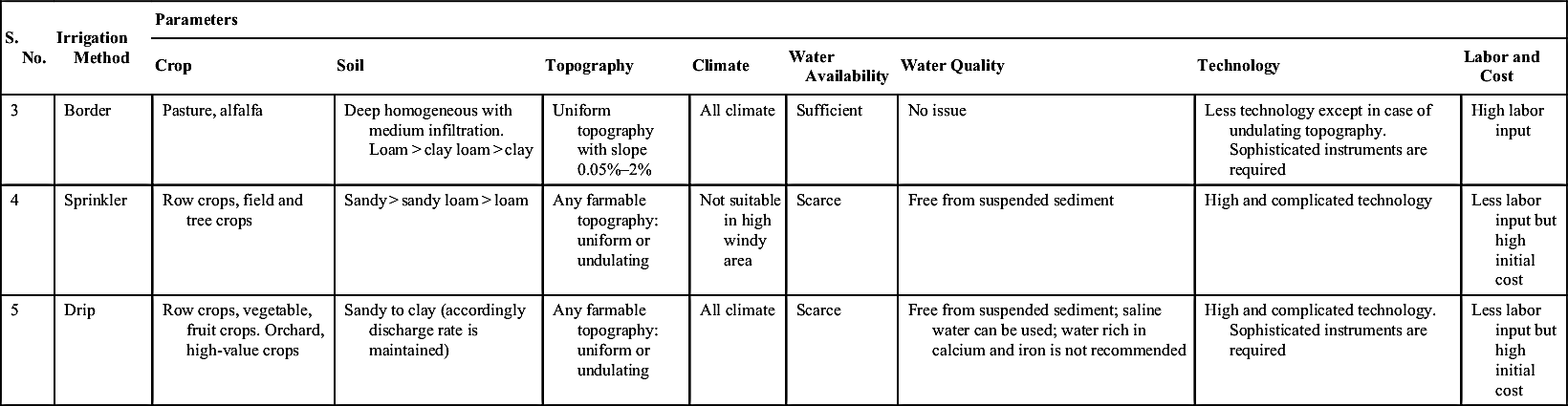
Table 10.2
Procedure for Selecting Irrigation Methods Based on the Merits/Demerits of Irrigation Methods
| S. No. | Irrigation Method | Parameters | |||||||
| Crop | Soil | Topography | Climate | Water Availability | Water Quality | Technology | Labor and Cost | ||
| 1 | Basin | Need standing water for crops (more than 24 h), like paddy. Other crops are alfalfa, clover; trees: citrus, banana; crops that are broadcast, such as cereals | Clay > clay loam > loam > sandy loam | Flatter land, uniform slope and terrace | All climate | Sufficient | No issue | Less technology except in case of undulating topography | High labor input |
| 2 | Furrow | Row crops: potato, tomato, fruit trees, maize, sunflower, sugarcane | Clay > clay loam > loam > sandy loam | Uniform topography. Slope <0.75%, slope <0.5% (high rainfall regions) | All climate | Sufficient | No issue | Less technology except in case of undulating topography | High labor input |
| Table Continued | |||||||||

| S. No. | Irrigation Method | Parameters | |||||||
| Crop | Soil | Topography | Climate | Water Availability | Water Quality | Technology | Labor and Cost | ||
| 3 | Border | Pasture, alfalfa | Deep homogeneous with medium infiltration. Loam > clay loam > clay | Uniform topography with slope 0.05%–2% | All climate | Sufficient | No issue | Less technology except in case of undulating topography. Sophisticated instruments are required | High labor input |
| 4 | Sprinkler | Row crops, field and tree crops | Sandy > sandy loam > loam | Any farmable topography: uniform or undulating | Not suitable in high windy area | Scarce | Free from suspended sediment | High and complicated technology | Less labor input but high initial cost |
| 5 | Drip | Row crops, vegetable, fruit crops. Orchard, high-value crops | Sandy to clay (accordingly discharge rate is maintained) | Any farmable topography: uniform or undulating | All climate | Scarce | Free from suspended sediment; saline water can be used; water rich in calcium and iron is not recommended | High and complicated technology. Sophisticated instruments are required | Less labor input but high initial cost |
Therefore the length of the basin is = 48 m.

10.4. Layout for Furrow Irrigation
Furrow irrigation system is generally used for row crops, including potato and tomato. It has an advantage that water is only applied into the furrows, and therefore some water is saved. Irrigation furrows may be classified, based on their alignment as (1) straight furrows and (2) contour furrows.
Straight furrows are best suited to sites where the land slope does not exceed 0.75%. In areas where intense rainfall occurs, the slope of the furrow should not exceed 0.5% to minimize erosion.
On the other hand, contour furrows are constructed along contours. The limitations of the straight furrow are overcome by contouring to include the slopping land.
In furrow layout, the shape, length, and spacing of furrows is determined on the basis of slope, soil type, and available stream size. However, other factors may also influence the design of a furrow system, such as the irrigation depth, farming practice, and the field length.
10.4.1. Furrow Length
An important factor that governs the length of the furrow is the infiltration rate of the soil, and it varies with slope, soil type, stream size, irrigation depth, cultivation practice, and field length. The impact of these factors on the furrow length is discussed in the following sections.
10.4.1.1. Slope
Furrow length can be considered high in the case of steeper land slopes, but the maximum allowable furrow slope to avoid soil erosion should be 0.5%. A minimum grade of 0.05% is recommended for effective drainage. In the case of land slope greater than 0.5%, contour furrows are recommended; however, for furrow irrigation, the maximum land slope should not exceed 3%.
10.4.1.2. Stream Size
The stream size determines the length of furrow. Less is the stream discharge, less will be the furrow length, and vice versa. For adequate irrigation supply, normal stream sizes for not long furrows can be up to 0.5 L/s. However, the maximum stream size should not exceed 3.0 L/s to avoid soil erosion (Table 10.4).
10.4.1.3. Irrigation Depth
Table 10.4 gives the guidelines for the irrigation depth, depending on the furrow length and stream size. For the application of larger irrigation depths in long furrows/channels, travel time will be high to reach the tail end of the furrow.
10.4.1.4. Field Length
It is recommended to use the furrow length equal to the length of the field, instead of the ideal length (i.e., furrow lengths are made to fit the field boundaries). Also, the length of field may be much less than the maximum furrow length.
For guidance, some practical values of maximum furrow lengths under small-scale irrigation conditions are given in Table 10.5.
Furrow shape: The shape of furrows is influenced by the soil type and stream size. In sandy soils, a deep V-shaped furrow is recommended as the water moves faster vertically rather than transversely, whereas for clayey soil, the shape can be considered parabolic to infiltration. For a larger stream, a larger cross-section can be considered, although it also depends on the crop type.
Table 10.5
Practical Values of Maximum Furrow Lengths (m) Depending on Slope, Soil Type, Stream Size, and Net Irrigation Depth
| Furrow Slope (%) | Maximum Stream Size (L/s) Per Furrow | Clay | Loam | Sand | |||
| Net Irrigation Depth (mm) | |||||||
| 50 | 75 | 50 | 75 | 50 | 75 | ||
| 0.0 | 3.0 | 100 | 150 | 60 | 90 | 30 | 45 |
| 0.1 | 3.0 | 120 | 170 | 90 | 125 | 45 | 60 |
| 0.2 | 2.5 | 130 | 180 | 110 | 150 | 60 | 95 |
| 0.3 | 2.0 | 150 | 200 | 130 | 170 | 75 | 110 |
| 0.5 | 1.2 | 150 | 200 | 130 | 170 | 75 | 110 |

Furrow spacing: Furrow spacing is governed by the soil type and the cultivation practice. For sandy soil, spacing should be between 30 and 60 cm (i.e., 30 cm for coarse sand and 60 cm for fine sand), whereas for clay soils the spacing between two adjacent furrows should be kept between 75 and 150 cm. On clay soils, double-ridged furrows, sometimes called beds, can also be used, which has the advantage that more plant rows are possible on each ridge. It also facilitates manual weeding. The ridge should be made slightly rounded at the top to drain off water during heavy rainfall. Furrow spacing also depends on the type of machinery used to construct furrows.
Table 10.6
Suggested Maximum Border Lengths and Widths
| Soil Type | Border Slope (%) | Unit Flow Per Unit Width of Border (L/s/m) | Border Width (m) | Border Length (m) |
| Sand | 0.2–0.4 | 10–15 | 12–30 | 60–90 |
| Infiltration rate >25 mm/h | 0.4–0.6 | 8–10 | 9–12 | 60–90 |
| 0.6–1.0 | 5–8 | 6–9 | 75 | |
| Loam | 0.2–0.4 | 5–7 | 12–30 | 90–250 |
| Infiltration rate of 10–25 mm/h | 0.4–0.6 | 4–6 | 6–12 | 90–180 |
| 0.6–1.0 | 2–4 | 6 | 90 | |
| Clay | 0.2–0.4 | 3–4 | 12–30 | 180–300 |
| Infiltration rate <10 mm/h | 0.4–0.6 | 2–3 | 6–12 | 90–180 |
| 0.6–1.0 | 1–2 | 6 | 90 |
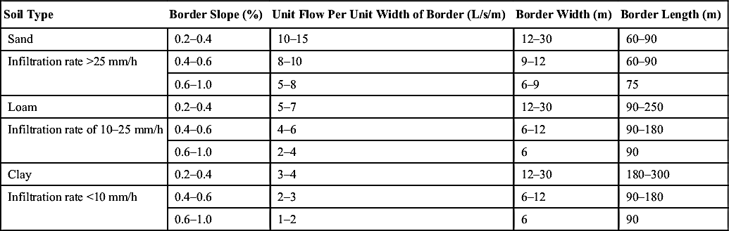
10.5. Layout of Border Irrigation
The dimensions and shape of borders are also influenced by the soil type, stream size, slope, irrigation depth, and other factors, such as farming practices and field or farm size.
Table 10.6 gives the general guideline to determine the maximum border. However, the best dimensions should be considered on the basis of field experience and local conditions.
10.6. Concluding Remarks
This chapter focuses on the application of various methods of irrigation to the field and their suitability for various types of crops, soil, and topography. The application of irrigation methods governs the field application losses and causes the major loss generally experienced in irrigation projects. To improve the project efficiency, one can shift from surface irrigation method to pressurized irrigation method, depending on the financial ground and power availability. For maximizing field application efficiency, for any method the more important factor is discipline among farmers.
..................Content has been hidden....................
You can't read the all page of ebook, please click here login for view all page.