Coal resources and reserves
Abstract:
Coal resources still make up a significant proportion of the world’s energy supplies. Coal resources are estimated to be 860 billion tonnes. These resources are geographically well distributed and current production provides fuel for 29% of the world’s primary energy consumption. The classification of coal resources and reserves has been redefined in recent years, with the standards and codes of practice adopted by the principal coal-producing countries being equated on a global basis. Details of the principal classifications are given, together with their international equivalents. Reporting of resources and reserves plus methods of calculation are also given, together with recent assessments of global coal reserves.
4.1 Introduction
In most industrialised countries coal has historically been a key source of energy and a major contributor to economic growth. In today’s choice of alternative sources of energy, industrialised economies have seen a change in the role for coal. In addition, countries with no previous coal mining history are now major players in the international coal market, both as producers and consumers.
The fact remains that many economies still depend on coal for a significant portion of their energy needs. Of the world’s consumption of primary energy, coal accounts for 29%, and provides fuel for 42% of the world’s electricity generation. In 2010, traded black coal (bituminous coal and anthracite) reached 938 Mt, of which 676 Mt was steam or thermal coal and 262 Mt was coking or metallurgical coal.
The world’s proven coal reserves are currently estimated to be around 860 billion tonnes, and have a widespread distribution throughout the world. Table 4.1 gives a percentage breakdown of the global distribution of Proved coal reserves in 2011 (BP Statistical Review, 2012).
4.2 Classification of coal resources and reserves
The demand for increased production of coal and the requirement of international finance to develop coal mining operations have led to the redefining of the classification of coal resources and coal reserves.
A committee of the Council of Mining and Metallurgical Institutions from Australia, Canada, Chile, South Africa, United Kingdom and Western Europe and United States, referred to as the Combined Reserves International Reporting Standards Committee (CRIRSCO), was formed in 1994 to bring a degree of uniformity to the various resource/reserves classifications used around the world. CRIRSCO is recognised by the United Nations Economic Commission for Energy (UNECE), the International Council on Mining and Metals (ICMM) and the International Accounting Standards Board (IASB). In 2006 CRIRSCO reached a provisional agreement for the use of standard definitions for mineral resources and ore reserves. However, the CRIRSCO template is non-binding and does not account for local regulatory reporting requirements. The countries and codes of practice recognised under the CRIRSCO template are Australia JORC (2004), Canada CIM Standards (2010), Western Europe PERC (2008), and South Africa SAMREC (2009). In addition, the UN has developed UNFC (2009).
The major coal-producing countries of People’s Republic of China, Eastern Europe, India and those in the former USSR are now adapting their reporting systems to be compatible with these international guidelines. Traditionally, these countries have operated a state-run industry which had totally different economic parameters. The current development of a globally integrated reporting system is a work in progress.
For projects to receive international finance, documentation detailing exploration results and coal resources and reserves must be prepared by, or under the direction of, and signed by a Competent Person or Persons. Such a Competent Person must be a professional member of an approved institution, who has the responsibility of ensuring that the applicable rules, regulations and guidelines pertaining to the particular country are adhered to.
Although there are some differences, the following description outlines the codes and systems adopted by the major coal-producing countries.
4.2.1 Australia
The JORC Code had been adopted by the Australasian Institute of Mining and Metallurgy (AusIMM) and the Australian Institute of Geosciences (AIG), and has been incorporated in the listing rules of the Australian and New Zealand stock exchanges. Although other variations of resource/reserve classification codes are currently used and/or are proposed for international use, as described below, the JORC Code is widely used, and stock exchanges and financial institutions are now fully familiar with its principles and definitions. The main principles governing the application of the JORC Code (2004) are clarity of report, inclusion of all relevant data pertaining to the judgement of the status of mineral resources and ore reserves, and competency, i.e. carried out by suitably qualified and experienced persons approved by a recognised professional body. The JORC Code is applicable to all solid minerals and, for the purposes of public reporting, the requirements for coal are generally similar to those for other commodities. The JORC Code uses the following definitions:
(i) Points of Observation are intersections of coal-bearing strata at known locations which provide information to varying degrees of confidence about the coal by observation and measurement of surface or underground exposures, borehole cores and openhole cuttings, and downhole geophysical logs. Points of observation for coal quality are obtained from exposure and/or borehole core sampling, the latter having an acceptable level of recovery (95% linear recovery).
(ii) Interpretive Data are observations supporting the existence of coal and include results from mapping and geophysical surveys.
(iii) Exploration Results are reports of coal occurrences which, due to insufficient data, cannot be given a resource value or quality parameters.
The relationship between mineral resources and mineral reserves is shown in Fig. 4.1 (Thomas, 2013).
4.1 Relationship between mineral resources and mineral reserves (Thomas, 2013). (Source: Reproduced with permission of PERC and CRIRSCO.)
The JORC Code (2004) gives the following classification:
Coal Resources
(i) A Resource is an occurrence of coal in such form, quality and quantity that there are reasonable prospects for eventual economic extraction.
(ii) Inferred Resource is that part of a coal resource for which tonnage and quality can be estimated at a low level of confidence using outcrops, pits, workings and boreholes. The number and distribution of points of observation plus interpretive data, if available, should provide sufficient understanding of the geology to estimate continuity of coal seams, range of coal thickness and coal quality. Inferred coal resources may be estimated using points of observation up to 4 km apart.
(iii) Indicated Resource is a coal resource with a higher confidence level. The points of observation plus interpretive data are sufficient to allow a realistic estimate of average coal thickness, areal extent, depth range, quality and in situ quantity. Such a level of confidence will be sufficient to generate mine plans and estimate the quantity of product coal. Indicated resources may be estimated using data obtained from points of observation normally less than 1 km apart. Trends in coal thickness and quality should not be extrapolated more than half the distance between points of observation.
(iv) Measured Resource is a coal resource where the points of observation, which may be supplemented by interpretive data, are sufficient to allow a reliable estimate of average coal thickness, areal extent, depth range, quality and in situ quantity. This is to provide a level of confidence sufficient to generate detailed mine plans and determine mining and coal beneficiation costs plus the specification for a marketable product. Measured coal resources may be estimated using data obtained from points of observation normally less than 500 m apart. This distance may be extended if the Competent Person considers that any variation to the estimate would be unlikely to significantly affect potential economic viability.
Coal resource estimates are not precise calculations, as they are dependent on the interpretation of limited information on the extent, continuity and thickness of coal seams and their quality.
Coal Reserves
(i) A Coal Reserve is the economically mineable part of a measured and/or indicated resource. It includes diluting materials and allowances for mining losses.
(ii) Probable Coal Reserve is the economically mineable part of an indicated and, in some circumstances, a measured coal resource. Allowances are made for losses in mining and dilution. Factors such as mining method, marketing, legal, environmental, social and governmental have been assessed to demonstrate that at the time of reporting, coal mining can be justified.
(iii) Proved Coal Reserve is the economically mineable part of a measured coal resource. Allowances are made for losses in mining plus the factors given for Probable coal reserves. Proved coal reserves have been assessed to demonstrate that at the time of reporting, coal mining can be justified. Proved coal reserve is the highest confidence category of coal reserve estimates.
(iv) Marketable Coal Reserve represents tonnages of coal that will be available for sale, either as raw coal or beneficiated or otherwise enhanced coal product, where modifications to mining, dilution and processing have been considered. These may be reported with, but not instead of, coal reserves.
4.2.2 Canada
The Canadian Institute for Mining, Metallurgy and Petroleum (CIM) approved the CIM Standards on Mineral Resources and Reserves – Definitions and Guidelines in 2000. This was updated in 2010 to reflect the more detailed guidance available, and maintain consistency with current regulations.
The mineral resource and reserve categories laid down are similar to those in the CRIRSCO template and JORC Code (2004) and require the same level of Competent Person affiliated to an approved professional institution. As in JORC, resources are reported in ascending order of technical certainty as inferred, indicated and measured resources. Reserves are also reported as Probable and Proven reserves using the same criteria as in JORC (2004). The CIM guidelines are slightly more rigorous in terms of what a reasonable level of confidence entails. Spacing must be close enough for geological and quality continuity to be reasonably assessed.
All technical reports that disclose information about exploration or other mining properties to the public are governed by a number of regulations in Canada. For coal mining and other mineral properties it is the National Instrument (NI) 43–101. Guidelines are also set out in the Geological Survey of Canada Paper 88–21, ‘A standardised coal resource/reserve reporting system for Canada’, (Hughes et al., 1989) but these must be in accordance with the CIM definition categories for public reporting.
In 1997, the Ontario Securities Commission and the Toronto Stock Exchange established the Mining Standards Task force, which in 1999 recommended the adoption of the CIM Standards through NI 43–101.
All of the other international guidelines imply that there can be no fixed definition for the term ‘economic’, but that it is expected that companies will attempt to achieve an acceptable return on capital invested. In contrast, CIM guidelines consider that a comprehensive study of the viability of the coal project must have been performed, which includes mining method, pit configuration, coal preparation (if required) and demonstrates that economic extraction is justified.
4.2.3 Europe
The Pan-European Reserves and Resources Reporting Committee (PERC) Code (2008) sets out the minimum standards, recommendations and guidelines for public reporting of exploration results, mineral resources and mineral reserves in the United Kingdom, Ireland and Europe. The committee comprises personnel from the Institute of Materials Minerals and Mining, the Geological Society of London, the European Federation of Geologists and the Institute of Geologists of Ireland. The PERC Code draws from and is consistent with the CRIRSCO template and national codes from which it is derived. The definitions in the PERC Code are either identical to or not materially different from those international definitions; the relationship of coal resources and coal reserves again conform, as shown in Fig. 4.1 (Thomas, 2013).
As in the case of the JORC Code, coal resources are subdivided in order of increasing geological confidence, i.e. inferred, indicated and measured categories. Specific distances between points of observation are not given, but in the case of indicated coal resources, locations are too widely or inappropriately spaced to confirm geological and/or quality continuity, but are spaced closely enough for continuity to be assumed. In the case of measured coal resources, the points of observation are spaced closely enough to confirm geological and quality continuity. In deciding between measured coal resources and indicated coal resources, the Competent Person may consider that any variation from the estimate would be unlikely to significantly affect potential economic viability.
Coal reserves are defined as the economically mineable part of a measured and/or indicated coal resource. They include dilution of materials and losses occurring when coal is mined. Coal reserves are subdivided in order of increasing confidence into Probable coal reserves and Proved coal reserves. When reporting coal reserves, a clear distinction must be made between reserves where mining losses have been taken into account (known as Recoverable reserves or Run of Mine) and saleable product where both the mining and processing losses have been included (known as Marketable reserves). The bases used to measure coal quality should also be clearly reported.
Prior to the PERC Code, countries such as UK and Germany used classifications developed by their publicly owned coal industries, chiefly for the underground mining of black coal (Cook and Harris, 1998). These industries have now disappeared, and private coal mining companies needing to finance mining operations are working to CRIRSCO Codes requirements.
4.2.4 South Africa
In South Africa, the South African Code for Reporting of Mineral Resources and Mineral Reserves, the SAMREC Code (2009), is applicable to all minerals for which public reporting of exploration results, mineral resources and mineral reserves. This is required by the Johannesburg Stock Exchange. Again, the SAMREC Code is virtually identical to the JORC and CIM Codes.
4.2.5 United Nations
In 2007, the Committee for Sustainable Energy of the Economic Commission for Europe (ECE) directed the Expert Group on Resource Classification (previously the Ad Hoc Group of Experts on Harmonization of Fossil Energy and Mineral Resources Terminology) to develop a revised United Nations Framework Classification for Fossil Energy and Mineral Resources, which would have worldwide application. This has resulted in the development of the United Nations Framework Classification for Fossil Energy and Mineral Reserves and Resources (UNFC, 2009). This classification is considered to be universally acceptable and internationally applicable for the classification and reporting of fossil energy and mineral resources and reserves, and the ECE believe that this is the only current classification in the world to do so.
UNFC (2009) applies to fossil energy and mineral resources and reserves located on or below the earth’s surface. It has been designed to meet the needs of applications pertaining to energy and mineral studies, resource management functions, corporate business processes and financial reporting standards. UNFC (2009) is a generic principle-based system in which quantities are classified on the basis of the three fundamental criteria of economic and social viability (E), field project status and feasibility (F), and geological knowledge (G), using a numerical coding system. Combinations of these criteria enable a three dimensional system to be constructed.
The E category indicates the level of acceptability of social and economic conditions in order to establish the commercial viability of the project, taking into consideration the legal, regulatory and environmental conditions together with market prices. This is subdivided as:
E1 category indicates the extraction and sale of product has been confirmed to be economically viable.
E2 category indicates extraction and sale of product is expected to become economically viable in the foreseeable future.
E3 category indicates extraction and sale of product is not expected to become economically viable in the foreseeable future or evaluation is at a too early stage to determine economic viability.
The F category designates the level of investigation necessary to develop projects and produce mining plans. These range from early exploration through to a project which is mining and selling a product such as coal. Again this is subdivided as:
F1 category indicates the feasibility of extraction by a defined development project or mining operation has been confirmed.
F2 category indicates the feasibility of extraction by a defined development project or mining operation is subject to further evaluation.
F3 category indicates the feasibility of extraction by a defined development project or mining operation cannot be evaluated due to limited technical data.
The G category indicates the level of confidence in the geological knowledge and recoverability of the mineral, in this case, coal. Each discrete estimate reflects the geological knowledge and confidence associated with a specific part of a deposit. There is always a degree of uncertainty associated with mineral estimates. This uncertainty is communicated by quoting discrete quantities of decreasing levels of confidence (high, moderate and low). The G category is subdivided as:
G1 category is quantities and qualities associated with a known deposit that can be estimated with a high level of confidence.
G2 category is quantities and qualities associated with a known deposit that can be estimated with a moderate level of confidence.
G3 category is quantities and qualities associated with a known deposit that can be estimated with a low level of confidence.
G4 category is for estimated quantities and qualities associated with a potential deposit, based primarily on indirect evidence.
Unlike JORC (2004), UNFC (2009) appears to give no precise definition of the levels of concentration of data points for each G category.
In addition to the E, F and G categories, subcategories are represented by a numerical code, the lowest numbers indicating the highest level of confidence. As the categories are always quoted in the same order, only the numerical codes are used as these are considered to be understood universally. The relationship of the three categories and their numerical notation indicating increasing levels of confidence are summarised in Table 4.2 (UNFC, 2009). These can then be assigned classes and subclasses to indicate the status of any project.
Table 4.2
UNFC-2009 fossil energy reserves and resources primary classes
Source: Based on UNFC, 2009.
Although the UNFC-2009 system is being adopted by a number of coal-producing countries, it is fair to say that the current preference of western finance houses and stock exchanges has been to use the JORC Code or the Canadian NI 43–101 guidelines when assessing project finance.
4.2.6 USA
Prior to the international rationalisation of the reporting of mineral resources, the United States Geological Survey had proposed and published a coal resource classification system (Wood et al., 1983). The system was the precursor to the subsequent classifications, notably the JORC Code.
Coal resources and reserves are classified on the basis of geological certainty and economic feasibility of their recovery, together with legal, environmental and technical considerations. The term ‘resource’ is defined as naturally occurring deposits of coal in the earth’s crust in such form and amounts that economic extraction is currently or potentially feasible.
Geological certainty is related to the distance from points where coal is measured or sampled, thickness of coal and overburden, knowledge of rank, quality, depositional history, areal extent, correlations of coal seams and associated strata, and structural history.
The economic feasibility of coal recovery is affected not only by geological factors but also by economic variables, such as the price of coal against mining costs, coal preparation costs, transport costs and taxes, environmental constraints, and changes in the demand for coal.
The term ‘resource’ is defined as naturally occurring deposits of coal in the earth’s crust in such forms and amounts that economic extraction is currently or potentially feasible.
The hierarchy of coal resources/reserves categories outlined by the United States Geological Survey is given in Fig. 4.2, and the application of the reliability categories based on distance from points of measurement, i.e. coal outcrops and boreholes, by the United States Geological Survey is demonstrated in Fig. 4.3.
4.2 Criteria for distinguishing coal resource categories, adapted from US Geological Survey hierarchy of coal resources. anth = anthracite; bit = bituminous; subbit = subbituminous; lig = lignite. (Source: Thomas, 2013, after Wood et al., 1983.)

4.3 Diagram showing reliability categories based solely on distance from points of measurement. (Source: Thomas, 2013, from Wood, 1983.)
Original Resources is the amount of coal in place before production; the total of original resources is the sum of the Identified and Undiscovered Resources plus the coal produced and coal lost in mining.
Remaining Resources includes all coal after coal produced and coal lost in mining are deducted.
Identified Resources are those resources whose locations, rank, quality and quantity are known or estimated from specific geological evidence. The levels of control or reliability can be subdivided into inferred, indicated and measured resources.
These subdivisions are determined by projecting the thickness of coal, rank and quality data from points of measurement and sampling on the basis of geological knowledge.
Inferred Resources are assigned to individual points of measurement which are bounded by measured and indicated coal for 1.2 km, succeeded by 4.8 km of inferred coal. Inferred resources include anthracite and bituminous coal 0.35 m or more in thickness and subbituminous coal and lignite 0.75 m or more in thickness to depths of not more than 1800 m. Coal resources outside these limits are deemed hypothetical in nature.
Indicated Resources are assigned to individual points of measurement bounded by measured coal for 0.4 km succeeded by 0.8 km of indicated coal. Indicated resources have the same thickness and depth limits as inferred resources.
Measured Resources are determined by the projection of the thickness of coal, rank and quality data for a radius of 0.4 km from a point of measurement. Measured resources also have the same thickness and depth limits as indicated and inferred resources.
The Reserve Base is identified coal defined only by physical and chemical criteria as determined by the geologist. The concept of the Reserve Base is to define a quantity of in-place or in situ coal, any part of which is, or may become, economic. This will depend upon the method of mining and the economic assumptions that will be used.
The Reserve Base includes coal categories based on the same distance parameters given for coal resources but further defining the coal thickness and depth criteria, i.e. anthracite and bituminous coal to be 0.7 m or more, subbituminous coal to be 1.5 m or more, all to occur at depths not more than 300 m, lignite to be 1.5 m or more at depths not greater than 150 m.
Inferred Reserves include all coal conforming to the thickness and depth limits defined in the Reserve Base, and bounded by the same distance limits as given for inferred resources.
Indicated Reserves include all coal conforming to the thickness and depth limits defined in the Reserve Base, and bounded by the same distance limits as given for indicated resources.
Measured Reserves include all coal conforming to the thickness and depth limits defined in the Reserve Base, and bounded by the same distance limits as given for measured resources.
Marginal Reserves are those reserves that border on being economic, i.e. they have potential if there is a favourable change in circumstances, mining restrictions are lifted, quality requirements are changed, lease areas become available, or there is a newly created demand for the type of coal held in this reserve category.
Subeconomic Resources are those in which the coal has been lost in mining, is too deeply buried, or seam thickness becomes too thin, and/or the coal quality deteriorates to unacceptable limits.
Following on from this systematic attempt to classify coal resources and reserves, the United States in 1997, in association with the other members of CRIRSCO and the Society for Mining, Metallurgy and Exploration (SME), produced the Guide for Reporting Exploration Information, Mineral Resources and Mineral Reserves. The definitions given are again in broad agreement with the JORC Code. However, there are differences between the content of the SME Guide and the United States Securities and Exchange Commission (SEC), who have not accepted the internationally recognised concepts of reporting mineral resources and the signing off of technical reports by a Competent Person.
4.2.7 Russian Federation
The Russian system for reporting estimates of coal resources and reserves has a different objective from the CRIRSCO template. The Russian system comprises detailed documentation presented in a set format according to Russian Federation law, the primary purpose of which is the estimation and recording of the country’s coal assets. This contrasts with the CRIRSCO reporting template, which provides a standard terminology for use in assessing assets of projects and mining companies for disclosure to stock markets and financial institutions. The Russian standard of public reporting of exploration results, resources and reserves of solid minerals, including coal, has not been included in the range of internationally accepted standards and codes.
As in the case of other resource reporting systems, the Russian Federal Government Agency State Commission on Mineral Reserves (FGUGKZ) requires an independent audit on resource estimates to be carried out by recognised GKZ competent persons. These are normally members of the Society of Experts of Russia for Mineral Resource Usage (OERN), which is a member organisation of the European Federation of Geologists (EFG).
According to the level of geological knowledge, the Russian system identifies four levels of resource. These are in order of decreasing geological knowledge, A, B, C1 and C2. The Russian system also has additional categories of ‘prognostic resources’ designated P1, P2 and P3. These include resources less well known than C2 resources in descending order of knowledge and can represent those resources at a deeper level or outside the boundaries of the deposit under examination. The Russian classification also groups coal resources according to their geological complexity from 1st (simplest) to 4th (extremely complex). Category A resources are only in 1st level of geological complexity, category B resources are in 1st and 2nd levels of geological complexity, category C1 can include 1st, 2nd and 3rd levels of geological complexity and, where areas have been studied in detail, can include the 4th level of geological complexity. C2 category includes all four levels of geological complexity. The CRIRSCO measured and indicated resources are equivalent in terms of definition to Russian resource categories A, B, C1 and C2 based only on the level of geological knowledge (Dixon, 2010). The relationship between the Russian classification and the CRIRSCO template is shown in Fig. 4.4.
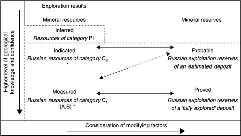
4.4 Relationship of Russian and CRIRSCO classifications. (Source: Thomas, 2013, from Dixon, 2010, reproduced with permission of GKZ and CRIRSCO.)
Two levels of modifying factors are also determined; these represent a lower level of detail required for a Technical-Economic Justification (TEO) of provisional conditions, i.e. a pre-feasibility study, and a higher level of detail required for a TEO of permanent conditions i.e. a full feasibility study. These two documents equate to an estimated coal deposit and a fully explored coal deposit. In addition, resources are classified into two categories according to their economic significance. These are ‘balanced’ resources, which are economically exploitable, and ‘off balanced’ resources, which are only potentially economic. Balanced resources represent tonnage and qualities before any dilution or mining losses are applied. Once such losses are applied, these are then referred to as Exploitation Reserves (or Industrial Reserves); these correspond to the Probable and Proved coal reserves categories in the CRIRSCO reporting template (Fig. 4.4).
It should be noted that the countries in Eastern Europe which have previously used the Russian classification are now reviewing their classifications and some are recommending the adoption of the UNFC-2009 Code, e.g. Serbia (Ilic et al., 2009).
The conversion of coal resources/reserves estimated according to the Russian system as equivalents in the CRIRSCO reporting template e.g. the JORC Code, again requires the signature of a Competent Person.
4.2.8 People's Republic of China
The traditional Chinese resource classification was developed from the former Soviet system, and is now phased out. This classification used categories A to F based on decreasing levels of geological confidence. This was replaced with the 1999 Chinese Mineral Resource/Reserve Classification, which was based in part on the 1999 United Nations Framework Classification of Fossil Energy and Mineral Resources (UNFC), which included the incorporation of CRIRSCO definitions (in 1998). This classification has been reviewed in 2007/2008 as the current Chinese Classification system was not regarded as particularly useful for reporting in a market economy. It was not easily comparable with the CRIRSCO group of codes such as the JORC Code (Stoker, 2009).The updated 2004 Chinese Mineral Resource/Reserve Classification classifies resources/reserves on the basis of geological knowledge and interpreted continuity (the UNFC ‘G’ category), and on the basis of project economics and feasibility study status (UNFC ‘F’ and ‘E’ categories). The system contains 16 categories, which are referenced by a three digit number in the same EFG notation as outlined in the UNFC classification. Figure 4.5 illustrates this classification and includes the term ‘basic reserve’ (suffix ‘b’), which is the total quantity of in situ reserve which forms the basis for the Recoverable Reserve. The EFG system has, in addition, the letter ‘M’ put after the E category for Marginally Economic Reserves, and the letter ‘S’ after the E category for Sub-Marginally Economic Reserves. Historically, there has also been a category of ‘Undiscovered Resources’, which has no equivalent in the CRIRSCO Codes.
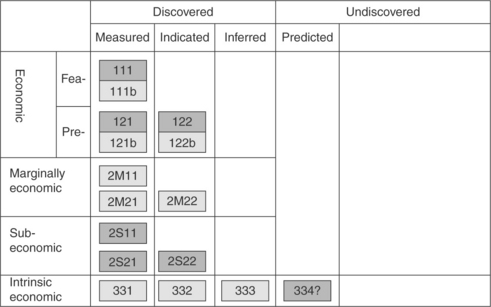
4.5 Chinese mineral resources and reserves classification (Stoker, 2009).
The requirement of a Competent Person to sign off on resource/reserve reporting is not applicable in People’s Republic of China. However, where foreign investors are involved, a Competent Person must provide a comparison between resource estimates which are non-compliant with CRIRSCO Codes and CRIRSCO Codes such as the JORC Code. The Chinese Classification system is currently under review to simplify its numerous categories and bring it into line with the CRIRSCO and JORC Codes (Stoker, 2009).
4.2.9 India
Indian coal resources are reported on the basis of the Indian Standard Procedure 1956. The Geological Survey of India locates coal-bearing areas and has assessed and classified coal into categories, inferred, indicated and proven. The Central Mine Planning and Design Institute then converts such ‘indicated’ reserves into the ‘proven’ category through detailed exploration. This is a geological resource classification without the assessment of coal quality or mineability of the coal. It has included coal resources that are unavailable for exploitation or areas sterilised by fire, etc.
Chand and Sarkar (2006) have stated that India is to review and follow the UNFC classification format so as to include economically mineable and technically feasible parts of a measured or indicated coal resource. This is reinforced in 2011 by The Energy Research Institute (TERI), which has stated that the total coal inventory is not so important; what is important is how technically feasible is it to mine the coal. TERI suggests that India should adopt the UNFC-2009 Code for resource/reserve classification (Kulkarni, 2011). This will give a more realistic assessment of India’s coal resources/reserves related to economic and technical viability.
4.3 Calculation of coal resources and reserves
The calculation of resources and reserves will be based on the following:
1. Details on each coal seam within the selected area.
2. On a depth basis, in regular depth increments if sufficient information is available.
3. On a seam thickness basis, the minimum coal thickness used and the maximum thickness of included non-coal bands should also be stated. Normally, where a seam contains a non-coal band thicker than 0.25 m the two coal splits can be regarded as separate seams, and tonnages should be reported for each. The limits for non-coal bands in brown coal sequences may be greater e.g. 1.0 m.
4. On a quality basis, maximum raw coal ash should be stated, and for Marketable reserves, only that coal that can be used or beneficiated at an acceptable yield (which should be stated) should be included in the estimate. Other raw coal parameters, particularly those which affect utilisation, should be given – e.g. total sulphur and calorific value. Subdivisions of the resources may be made for areas of oxidised coal and heat-affected coal.
5. Selection of a value for the Relative Density (RD) of the coal, necessary for coal tonnage calculations.
The geological information required for resource/reserve assessments is based on the points of measurement. Both for quantity and quality assessments it is important that the recorded information at the points of measurement is correctly compiled and is therefore reliable. If this is not the case, then making resource/reserve assessments is a useless exercise. If any point of measurement has a doubt against its reliability, this should be taken into account when the assessment is made.
Extrapolation from points of measurement up to the distance limits imposed by the resource/reserve category is based on the judgement and knowledge of the local geology. Geological hazards that need to be taken into account are faulting, seam thickness variations (particularly rapid thinning and splitting of seams), washouts, sharp changes in dip, and the presence of igneous intrusions.
The distance between points of measurement used for the different resource/reserve categories is theoretically the same for underground and opencast coal. If the geology is similar between two points the same distance apart at depth or near the surface, then the confidence level must be similar. However, shallow drilling is relatively cheaper and this allows for more holes to be drilled, and therefore the confidence level will be greater. In coal occurring near the surface, there are the additional problems of oxidation and, in some cases, zones of burning that have to be delineated. Deep boreholes are costly, so that at the exploration stage a lower level of confidence may be achieved; however, shallow seismic geophysical surveys can be used to supplement the drilling to ascertain any major structural disturbances and changes in thicknesses in the coal-bearing sequence.
The use of computers now allows the input of geological data into a geologically significant computer model of the deposit. In this way coal deposits can be subdivided into major block units, each equating to the proposed working district of a coal mine. Within these units, smaller structurally delineated blocks provide the basic geological data which are transformed into computer data. Within each of these smaller units the coal seams provide the basic data for the whole assessment, i.e. depth, thickness, dip and size of the area.
The basic formula to calculate coal resources is:

Coal thickness is determined at each point of measurement.
The area of each resource/reserve block is measured on the map or plan either by:
(i) using a planimeter, in the traditional way. The boundaries of each block area are traced and the area is calculated automatically and given as a reading.
(ii) entering the coordinates of each block area into a computer programme specified for the purpose, whereby an areal calculation is obtained.
The RD is normally taken from a total seam section, i.e. that section of the seam to be mined, not a density of the cleanest portion of the seam. In opencast mines this will usually be a whole seam section, whilst underground this is not always so; coal quality constraints or mining difficulties may mean mining only part of the seam.
If no density determination is available, an estimated density can be adopted based on the known average ash content of the seam; this would be in the order of 1.3–1.4 g/cm3 in coals with reasonably low ash contents.
This means that an area of one square kilometre (one million square metres), underlain by coal with a thickness of 1.0 m and with a density of 1.4 g/cm3, will contain 1.4 million tonnes of coal. Resource tonnages are usually quoted in million tonnes (Mt) and are usually rounded off to the nearest hundred thousand, ten thousand or one thousand tonnes depending on the degree of accuracy required.
Limits can be imposed and entered into the computer; for instance, the minimum coal thickness to be evaluated could be taken as 0.30 m whilst the minimum fault displacement to delimit a block could be 10.0 m and a depth limit stipulated beyond which coal is considered unworkable and/or uneconomic
From these data, the spatial position, form and area of all intermediate coal seams are calculated using a mathematical model. The top and bottom of a block are digitised to include regularly distributed depth values. On all the intermediate planes, sectional areas are defined by closed polygons. Data input of these sectional areas is done by digitising seam projections at 1:10 000 scale. Straight lines joining corresponding points on the top and bottom planes define the lateral delineation of the block on all intermediate planes and also all in-between sectional areas, as shown in Fig. 4.6.

4.6 Schematic diagram of the calculation of sectional areas using the block model for coal resource/reserve calculations. (Source: Thomas, 2013, based on Juch et al., 1983.)
In areas previously worked, the percentage of the worked areas is estimated for each sectional area, and has to be subtracted in the process of calculation.
In a similar fashion, other coal seam data can be built into the computer model, such as seam thickness and coal quality data. It can be seen that computers now provide a means whereby statistical confidence criteria can be provided on a regular basis. The main limitation of these methods is the amount and quality of data required, and the reliability of geological and geophysical interpretation. Most methods require data points relatively close together and evenly spaced; such conditions are likely to occur only in fairly well-defined coal deposits.
Before the advent of computer programmes, traditional methods of calculation were used, and they can still be useful in providing a quick calculation for planning purposes as well as a backup to verify computerised results. A common method of calculation of coal resources has been the polygon or area of influence technique. This method assigns an area to a point of measurement which is a function of the distance to the immediate neighbouring points of measurement. A polygon is formed from joining the mid points between the point of measurement and those surrounding it, resulting in the original point of measurement forming the centre of the polygon. A practical development of the polygon method is to outline reserve zones containing several points of measurement, calculate the area of the zone, and use an average or weighted mean seam thickness for each zone.
Many areas are insufficiently well delineated, either by outcrops or drill holes, so that some boundary of arbitrary width needs to be placed around the drilled portion of the deposit. If the deposit is large, a subjective selection of the boundary zone width is satisfactory, because a moderate change in width will not substantially alter the total area of the deposit. However, if the deposit is small, a significant proportion of the reserves may lie within the boundary zone. The calculated reserves therefore will be unreliable because of their dependence on the subjective selection of the boundary zone.
The calculation of Recoverable or Extractable reserves requires the identification of those geological constraints that are likely to inhibit mining. Such constraints include the identification and positioning of fault zones, changes in dip, washouts, seam splitting and thinning, losses in quality, and igneous intrusions. In opencast workings, reserves will be affected by deleterious changes in the stripping ratio. All these factors contribute to a reduction in the mineable in situ reserve figure and are known collectively as geological losses.
In underground workings, the method of mining will influence those geological losses deducted from the mineable in situ reserve figure. If the method to be used is longwall mining, a larger geological loss will occur, due to the fact that longwall operations need hazard-free runs in a designated panel of coal. All faulted areas will need to be discounted if their amounts of throw displace the coal seam to be mined out of line with the preset coal shearer. If the coal panels between faults are too small, then the whole block may be discounted. If the bord and pillar (= room and pillar) method is adopted, small faults can often be worked through, and in some cases igneous intrusions can be worked around, as is the case with some South African coal mines. This method also allows for small blocks of coal to still be taken. All methods of mining are affected when coal is lost through washouts and changes in seam thickness or seam quality.
Geological losses will vary considerably from mine to mine but, in general, in opencast operations a 10% geological loss can be expected, whereas in underground operations, geological losses of 25–50% may occur.
In addition, losses other than geological may need to be accounted for at this stage. Areas close to lease boundaries may be discounted, as well as reserve areas which run beneath railways, motorways and critical buildings and installations. Those reserves deemed recoverable may in certain circumstances have a minimum depth limit imposed. This is often the case where underground reserves are accessed by drivages in from the base of the highwall in open pit workings. Such limits will be determined according to the nature of the particular surface area, and are intended to reduce the effects of subsidence, particularly close to areas of urban population.
In open pit mines, the effects of depth can produce an increase in the stripping ratio (SR) i.e. the overburden to coal ratio, quoted as bank (in situ) cubic metres (bcm) of overburden per tonne of coal, calculated as follows:

As open pit excavations get deeper, the SR will become uneconomic at some point, besides imposing geotechnical constraints on the stability of the open pit configuration.
4.4 Reporting of coal resources and reserves
Any report of resources and reserves should be accompanied by maps and plans at appropriate scales showing all the relevant data. Such maps and plans should show those areas assigned to each category of resources/reserves, seam depth and seam thickness isopachs, coal quality distribution for each seam, and indicate all areas not to be mined.
Reporting will be tailored to whether the resources and reserves are to be mined as an underground or open pit operation, methods of mining, and suitability of the coal(s) to match quality specifications required by potential customers.
Using the above calculations, the objective is to report firstly, mineable in situ reserves. To do this, the following information is required:
1. An outline of the proposed mining method, together with a conceptual mine plan.
2. In underground mines, the physical criteria limiting mining, such as maximum and minimum working section thickness, minimum separation of seams, the maximum dip at which the coal can be mined by the stated method, geological structure.
3. Overburden or SRs in opencast operations.
4. Quality restrictions, maximum and minimum levels for ash, sulphur, volatile matter, etc. In the case of coals that have quality problems and need to be beneficiated, the predicted yield needs to be given.
5. Depth limits, imposed by either physical or economic constraints or both.
Added to these are mining losses such as:
1. Areas where coal may not be mined, e.g. beneath motorways.
2. Stress fields in the coal seams, which may require the reorientation of reserve panels, and therefore loss of reserve.
3. Roof stability, affecting the thickness of pillars to be left in the mine, again producing loss of reserve.
These and other factors, once deducted from the measured in situ reserve, enable the measured Recoverable (or Extractable) reserves to be calculated. These are the reserves required by investors when considering any mine’s potential.
A summary of all the factors relevant in determining the categories of coal resources/reserves assessment are shown in Fig. 4.7. In the diagram, coal product value and yield are plotted against ease of mining, coal recovery and mining costs, and against geological certainty.

4.7 Variable factors in coal reserves assessment. (Source: Thomas, 2013, adapted from Ward, 1984.)
Where the mine configuration is known, and the production costs and sales figures are also known, it is possible to apply computer methods to determine pit areas of equal value. Such analysis has been applied to metalliferous mines but is equally applicable to modern open pit coal operations. Such an analysis does require considerable details of the coals mined, and the condition of the mine itself, e.g. whether it is a series of discrete open pits, or separate parts of a mine producing from different seams.
From this it is possible to understand the following relationships:
(a) physical (coal quantity and quality)
(b) rate dependent relationships (quantity of coal A per quantity of coal B)
(c) economic relationships and potential (cash flow against pit size).
Additional information, such as changes in mine access, and need for pit backfilling and restoration, all have an influence, as will primary drivers such as market price, market sustainability and environmental constraints.
4.5 World coal reserves
Estimates of proven coal reserves for black coal i.e. for anthracite and bituminous coals, and for brown coal i.e. subbituminous coal and lignite, are given in Table 4.3. These figures are taken from the World Energy Council (WEC) Survey of Energy Resources (2010) and from the BP Statistical Review of World Energy (2012). These proven reserves are those which can be regarded with reasonable certainty to be recoverable from known deposits under existing economic and operating conditions, and do not include those large resources of coal which are currently being, or will in the future, be fully evaluated.
Table 4.3
World coal reserves (million tonnes)

Source: Based on WEC, 2010 and BP Statistical Review of World Energy, 2012.
The table gives an overall total of 860 938 Mt for those known deposits in the world today. Such a figure in itself is meaningless, but the regional totals do give an indication as to the geographical distribution of the bulk of the world’s black coal (404 762 Mt) and brown coal (456 176 Mt) resources. Those countries with one million tonnes or less are omitted from the table.
In North America, South and Central America, Australia and China, reserves of black and brown coal are evenly divided. In Africa reserves are predominantly black coal, and in Europe and Eurasia there are greater reserves of brown coal (Table 4.3). The distribution of Proved reserves shows little change over the last 20 years, the chief increases being in the Asia Pacific region.
4.6 Future trends
The world consumption of fossil fuels will continue to increase; currently, they still meet around 90% of primary energy requirements. Coal is a major fuel source for electricity generation as well as for the metallurgical industry. The economic growth of countries such as People’s Republic of China, India and Indonesia has both increased the production and demand for coal, and although the older industrialised countries have reduced their dependence on coal as a fuel, the demand for coal, particularly ‘clean coal’, will only increase.
To meet the demands for coal, countries are reassessing their own coal resources. Some of these, previously considered uneconomically recoverable, in the current economic climate may now be viewed as economically mineable. Future exploration, both in traditional areas and new in coal deposits such as in Mongolia, will continue to be a feature over the coming decades.
4.7 References
, BP plc (2011) BP Statistical Review of World Energy, June 2012:45 pp. [London,].
Chand, S.K., Sarkar, S.K., Demystifying Coal Security. The Economic Times, India, 2006. [(14 April 2006)].
Cook, P.J., Harris, P.M. Reserves, resources & the UK mining industry. International Mining & Minerals, May 1998. 1998; 1(5):120–133.
Dixon, R., Chairman, Russian Federal Government Agency. Guidelines on Alignment of Russian Mineral Reporting Standards and the CRIRSCO Template. State Commission on Mineral Reserves (FGUGKZ) and Committee for Mineral Reserves International Reporting Standards (CRIRSCO), 2010:112 pp.
Hughes, J.D., Klatzel-Mudry, L., Nikols, D.J. A standardized coal resource/reserve reporting system for Canada. Geological Survey of Canada, Paper. 1989; 88–21:17.
Ilic, M., Pavlovic, V., Vukas, R., Beljic, C., A Comparative Analysis of Serbian and World Classifications of Mineral Reserves and Resources and Proposals for Innovation and Harmonisation of Serbian Classification. Proc. of 8th Int. Conf. Nonmetals 2009, 2009:1–12. [Vrujci Spa, Serbia].
Juch, D., Working Group, New methods of coal resources calculation CompteRendu, Instituto Geologico y Minero de Espana, Madrid. Symposium 5: Economic Geology: Coal Resources and Coal Exploration. Xth Congress on Carboniferous Stratigraphy and Geology, 1983:117–124. [Madrid, Spain, 12–17 September].
Kulkarni, V., The Truth about India’s Coal. The Hindu Business Line, 2011. [March 2011].
, PERC Pan-European Reserves and Resources Reporting Committee. The PERC Reporting Code 2008, 2008:51 pp.
Stoker, P., Progress on the revision of Chinese Mineral Resources and Mineral Reserves Reporting Standard. JORC Bulletin, 2009:20–21. [April].
Thomas, L.P., Coal Geology. 2nd Ed, 2013:444 pp. [Wiley-Blackwell].
, UNFC United Nations Framework Classification for Fossil Energy and Mineral Reserves & Resources. The United Nations Economic Committee for Europe (UNECE) Energy Series no.39, 2009:20 pp.
Ward, C.R. Coal Geology and Coal Technology. Oxford: Blackwell Scientific Publications; 1984. [345 pp].
Wood, G.H., Jr, Kehn, T.A., Devereux Carter, M., Culbertson, W.C., Coal Reserve Classification System of the US Geological Survey. USGS Circular No. 891, 1983:65 pp.