
One of the defining characteristics of a spatial database is the ability to create special spatial indexes to speed up geometry-based searches. These indexes are used to perform spatial operations such as identifying all the features that lie within a given bounding box, identifying all the features within a certain distance of a given point, or identifying all the features that intersect with a given polygon.
A spatial index is defined in the same way as you define an ordinary database index, except that you add the keyword SPATIAL to identify the index as a spatial index. For example:
CREATE TABLE cities (
    id   INTEGER AUTO_INCREMENT PRIMARY KEY,
    name CHAR(255),
    geom POLYGON NOT NULL,

    INDEX (name),
    SPATIAL INDEX (geom))
All three open source spatial databases we will examine in this chapter implement spatial indexes using R-Tree data structures.
Note
PostGIS implements R-Trees using PostgreSQL's GiST (Generalized Search Tree) index type. Even though you define your spatial indexes in PostGIS using the GIST type, they are still implemented as R-Trees internally.
R-Tree indexes are one of the most powerful features of spatial databases, and it is worth spending a moment becoming familiar with how they work. R-Trees use the minimum bounding rectangle for each geometry to allow the database to quickly search through the geometries using their position in space:
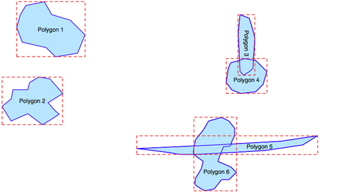
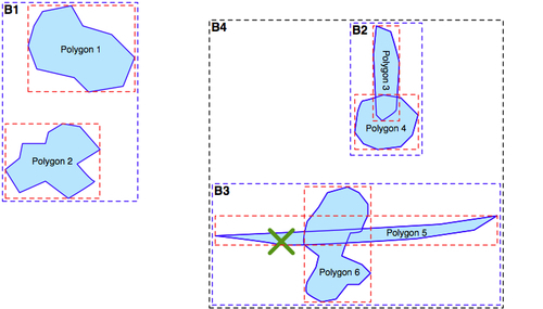
These bounding boxes are grouped into a nested hierarchy based on how close together they are:
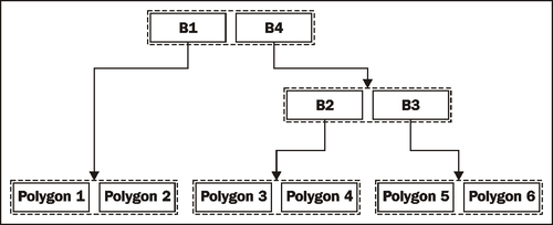
The hierarchy of nested bounding boxes is then represented using a tree-like data structure:
The computer can quickly scan through this tree to find a particular geometry, or to compare the positions or sizes of the various geometries. For example, the geometry containing the point represented by the X in the picture preceding the last one can be quickly found by traversing the tree and comparing the bounding boxes at each level. The R-Tree will be searched in the following manner:
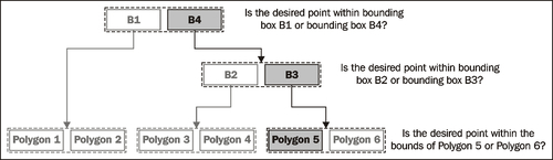
Using the R-Tree index, it only took three comparisons to find the desired polygon.
Because of the hierarchical nature of the tree structure, R-Tree indexes scale extremely well, and can search through many tens of thousands of features using only a handful of bounding box comparisons. And, because very geometry is reduced to a simple bounding box, R-Trees can support any type of geometry, not just polygons.
R-Tree indexes are not limited to only searching for enclosed coordinates; they can be used for all sorts of spatial comparisons, and for spatial joins. We will be working with spatial indexes extensively in the next chapter.