
Let's start our design of the DISTAL application by thinking about the various pieces of data it will require:
- A list of every country. Each country needs to include a simple boundary map that can be displayed to the user.
- Detailed shoreline and lake boundaries worldwide.
- A list of all major cities and towns worldwide. For each city/town, we need to have the name of the city/town and a point representing the location of that city or town.
Fortunately, this data is readily available:
- Country lists and outlines are included in the World Borders Dataset.
- Shoreline and lake boundaries (as well as other land-water boundaries such as islands within lakes) are readily available using the GSHHS shoreline database.
- City and town data can be found in two places: the Geonames Database provides official place-name data for the United States, while the GEOnet Names Server provides similar data for the rest of the world.
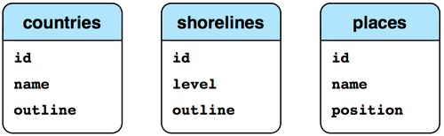
Looking at these datasources, we can start to design the database schema for the DISTAL system:
Note
The level field in the shorelines table corresponds to the level value in the GSHHS database: 1 = coastline, 2 = lake, 3 = island-in-lake, and 4 = pond-on-island-in-lake. All of these features, including the lake and shoreline outlines, will be stored in a single database table which we will name shorelines.
While this is very simple, it's enough to get us started. Let's use this schema to create our database, first in MySQL:
import MySQLdb

connection = MySQLdb.connect(user="...", passwd="...")
cursor = connection.cursor()

cursor.execute("DROP DATABASE IF EXISTS distal")
cursor.execute("CREATE DATABASE distal")
cursor.execute("USE distal")

cursor.execute("""
    CREATE TABLE countries (
        id      INTEGER AUTO_INCREMENT PRIMARY KEY,
        name    CHAR(255) CHARACTER SET utf8 NOT NULL,
        outline POLYGON NOT NULL,

        SPATIAL INDEX (outline))
""")

cursor.execute("""
    CREATE TABLE shorelines (
        id      INTEGER AUTO_INCREMENT PRIMARY KEY,
        level   INTEGER NOT NULL,
        outline POLYGON NOT NULL,

        SPATIAL INDEX (outline))
""")

cursor.execute("""
    CREATE TABLE places (
        id INTEGER AUTO_INCREMENT PRIMARY KEY,
        name CHAR(255) CHARACTER SET utf8 NOT NULL,
        position POINT NOT NULL,

        SPATIAL INDEX (position))
""")

connection.commit()
Note
Note that we define the country names and placename fields to use UTF-8 character encoding. This allows us to store non-English names into these fields.
The same code in PostGIS would look like this:
import psycopg2

connection = psycopg2.connect("dbname=... user=...")
cursor = connection.cursor()

cursor.execute("DROP TABLE IF EXISTS countries")
cursor.execute("""
    CREATE TABLE countries (
        id   SERIAL,
        name VARCHAR(255),

        PRIMARY KEY (id))
""")
cursor.execute("""
    SELECT AddGeometryColumn('countries', 'outline',
                             4326, 'POLYGON', 2)
""")
cursor.execute("""
    CREATE INDEX countryIndex ON countries
        USING GIST(outline)
""")

cursor.execute("DROP TABLE IF EXISTS shorelines")
cursor.execute("""
    CREATE TABLE shorelines (
        id   SERIAL,
        level INTEGER,

        PRIMARY KEY (id))
""")
cursor.execute("""
    SELECT AddGeometryColumn('shorelines', 'outline',
                             4326, 'POLYGON', 2)
""")
cursor.execute("""
    CREATE INDEX shorelineIndex ON shorelines
        USING GIST(outline)
""")

cursor.execute("DROP TABLE IF EXISTS places")
cursor.execute("""
    CREATE TABLE places (
        id   SERIAL,
        name VARCHAR(255),

        PRIMARY KEY (id))
""")
cursor.execute("""
    SELECT AddGeometryColumn('places', 'position',
                             4326, 'POINT', 2)
""")
cursor.execute("""
    CREATE INDEX placeIndex ON places
        USING GIST(position)
""")
connection.commit()
Note
Notice how the PostGIS version allows us to specify the SRID value for the geometry columns. We'll be using the WG84 datum and unprojected lat/long coordinates for all our spatial data, which is why we specified SRID 4326 when we created our geometries.
And, finally, using SpatiaLite:
from pysqlite2 import dbapi2 as sqlite

if os.path.exists("distal.db"):
    os.remove("distal.db")

db = sqlite.connect("distal.db")
db.enable_load_extension(True)
db.execute('SELECT load_extension("...")')
cursor = db.cursor()

# Load the SpatiaLite init file into our database.

f = file("init_spatialite-2.3.sql", "r")
lines = []
for line in f.readlines():
    line = line.rstrip()
    if len(line) == 0: continue
    if line.startswith("--"): continue
    if line.startswith("BEGIN"): continue
    if line.startswith("COMMIT"): continue
    lines.append(line)
f.close()
cmds = ("".join(lines)).split(";")
for cmd in cmds:
    cursor.execute(cmd)
db.commit()

# Create the database tables.

cursor.execute("DROP TABLE IF EXISTS countries")
cursor.execute("""
    CREATE TABLE countries (
        id   INTEGER PRIMARY KEY AUTOINCREMENT,
        name CHAR(255))
""")
cursor.execute("""
    SELECT AddGeometryColumn('countries', 'outline',
                             4326, 'POLYGON', 2)
""")
cursor.execute("""
    SELECT CreateSpatialIndex('countries', 'outline')
""")

cursor.execute("DROP TABLE IF EXISTS shorelines")
cursor.execute("""
    CREATE TABLE shorelines (
        id    INTEGER PRIMARY KEY AUTOINCREMENT,
        level INTEGER)
""")
cursor.execute("""
    SELECT AddGeometryColumn('shorelines', 'outline',
                             4326, 'POLYGON', 2)
""")
cursor.execute("""
    SELECT CreateSpatialIndex('shorelines', 'outline')
""")

cursor.execute("DROP TABLE IF EXISTS places")
cursor.execute("""
    CREATE TABLE places (
        id   INTEGER PRIMARY KEY AUTOINCREMENT,
        name CHAR(255))
""")
cursor.execute("""
    SELECT AddGeometryColumn('places', 'position',
                             4326, 'POINT', 2)
""")
cursor.execute("""
    SELECT CreateSpatialIndex('places', 'position')
""")

db.commit()
Now that we've set up our database, let's get the data we need for the DISTAL application.