
Exercise | Use Surveyor's Units
In this exercise, you set the drawing units to accept Surveyor's Units for angle input, and use the Dynamic Input interface to draw a site boundary.
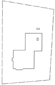
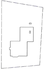
The completed exercise
Completing the Exercise
To complete the exercise, follow the steps in this book or in the onscreen exercise. In the onscreen list of chapters and exercises, click Chapter 2: Creating Basic Drawings. Click Exercise: Use Surveyor's Units.
![]()
- Open M_Survey-Units.dwg.
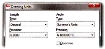
- To set the unit type:
- Click Application Button > Drawing Utilities > Units.
- In the Angle type list, select Surveyor's Units.
- In the Angle Precision list, select N 0d00′00″ E.
- Click OK.
- To draw a line:
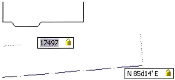
- On the Home tab, click Draw panel > Line.
- Enter 4000,4000. Press ENTER.
- Enter 17497. Press TAB.
- Enter N85d14′ E. Press TAB.
- Click anywhere in the drawing.
- For the next point:
- Move the cursor up and to the right from the previous point.
- Enter 25498. Press TAB.
- Enter N2d57’E. Press TAB.
- Click anywhere in the drawing.
- For the next point:
- Move the cursor up and to the left from the previous point.
- Enter 19000. Press TAB.
- Enter N80d40’ W. Press TAB.
- Click anywhere in the drawing.
- Right-click and click Close.
The site boundary appears as shown.
- Close all files. Do not save.
..................Content has been hidden....................
You can't read the all page of ebook, please click here login for view all page.